weatherwiz
-
Posts
79,817 -
Joined
-
Last visited
Content Type
Profiles
Blogs
Forums
American Weather
Media Demo
Store
Gallery
Everything posted by weatherwiz
-
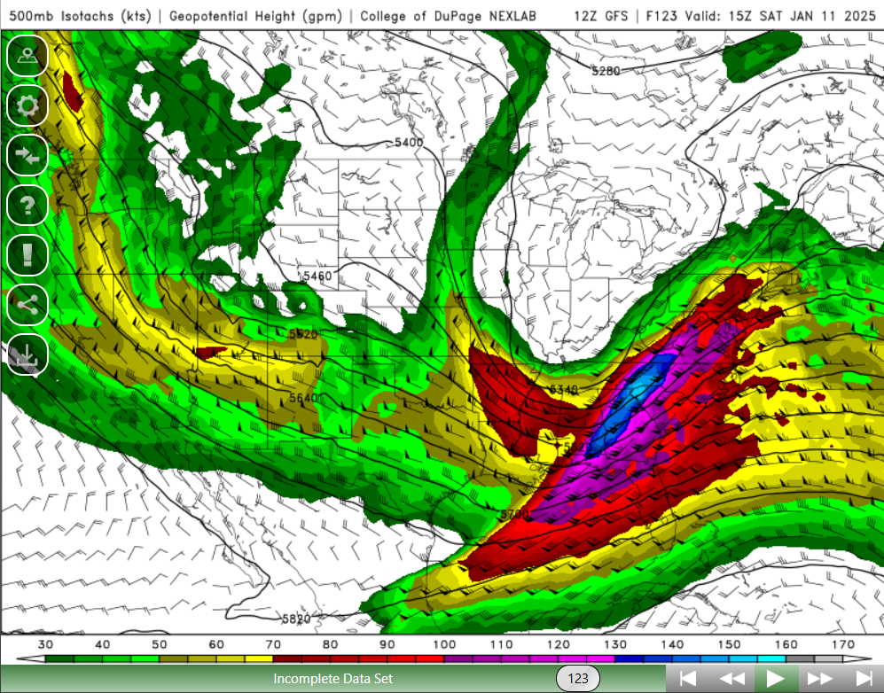
150+ knot 500mb jet streak develops as the core of the jet rounds the base across AL/GA...exactly what we want to see. Monster

-
I wonder that too. I would love to explore model verification scores more and understand the process. I feel like it has to be exceedingly difficult to truly assess model performance and equate that to a particular score because of how complex this is. When you see the graphs comparing model performance at like H5...what is it that explicitly measuring? Is it averaging like observed H5 globally compared to model forecast globally at a particular time? But say one model is handling H5 great overall, but it is weaker in a particular part of the world versus another area where a model with a lower score did better in the area the model with the higher score did...?
-
If it nails it that will be pretty impressive, but we're going to want to see AI become extremely consistent with nailing storms, otherwise all it is going to do is just add to the uncertainty when there is large model spread. But it also has to go beyond just nailing storms, it needs to be consistent with the evolution of all these features and how the features are interacting. For example, lets say it is OTS because of a lack of phasing and the storm does end up going OTS...well in a sense it was correct with the OTS, however, if there was phasing, just a bit too late which still resulted in an OTS track...well then it was not technically correct. While it had the correct solution, the reasoning was incorrect.
-
With these type of setups though, its almost irrelevant whether models show a storm or not. Slight tweaks in how the models evolve and interact with the H5 energy can have large impacts on how the sfc evolves. At some point you do want to see models become consistent with showing a storm and favorable track but I don't think that is very important right now...but that time is coming.
-
I would strongly advise giving the NAM little attention beyond 48 hours for this system with the only attention just comparing evolution of H5 through a 48-hour window....that is all. Beyond that, the NAM will be useless garbage.
-
I know GFS SLP maps don't show much behind next weekend but that pattern looks good for some clippers and would have to watch for quick development south of Long Island.
-
I lose patience easily as I get older
-
yeah its the wind. If it wasn't for the wind the 30F here would be much more tolerable. I can tolerate 25-30 (I hate it but tolerate it) but with wind....hellll no. I guess if there is a plus about this once we get back up to 35-45 that will feel more enjoyable.
-
It's brutal, especially with the breeze. I can't stand to be outside for more than 30 seconds. It's miserable.
-
Whatever happens with next weekend, I am ready for late spring and summer because this cold SUCKS. I mean it really freaking SUCKS.
-
Exactly what I'm thinking
-
Upper levels look pretty damn good. Perfect, no but given the stage we're at there isn't much more you can really ask for with the look.
-
Those are a waste, not sure why people waste time looking at those. Big deal they get something right every 5 years. Let's say one of these score a scoop over other guidance, 1) How the hell are you going to know that in advance? 2) Who would even take them seriously if they're deviating from other guidance?
-
MCI also closed
-
This is not even close to being done. Given the factors evolved, particularly with the idea of phasing northern/southern streams we aren't going to have a solid idea until probably Tuesday. My thinking is that beginning with Tuesday 12z run we are going to want to see continuity. At this point, we're going to continue seeing run-to-run differences with the handling of each stream and that is perfectly normal at this stage.
-
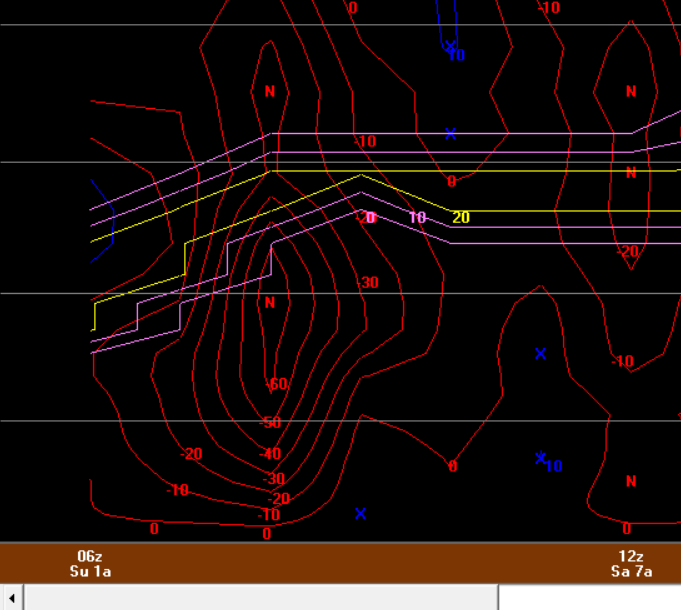
Going to be some serious thunder freezing rain and sleet tomorrow across southern Missouri through southern Illinois and Indiana. This sounding is nuts
-
I was a huge night owl as well. Used to stay up until all hours of the night and be out with friends until 1-2 AM. For some reason I always had more energy at night then during the day. But once I started working full time, I was working 6 AM - 3 PM and would have to wake up around 4:15-4:30 AM...that KILLED me. It was brutal, I had zero energy in the afternoon and weekends I was dead. I would try going to bed by 8 PM but I couldn't fall asleep until midnight. I ended up having to switch to do a typical 8-5. If I could though...I would love the earlier day, I wish I had the energy to wake up 5-6 AM. I actually grew to like some aspects of it but it was killing me. I don't know how people do it. I guess they must get like a solid 8 hours of sleep. My problem is I wake up every 2 hours or so.
-
Wouldn't like the 12z not be available until like 4-5-6 PM? and literally it was like one product freely available? I could be wrong but once I got introduced into forecast models I thought that's how it was.
-
100%. Swayman hold out for all this money to "set the goalie market" and all of a sudden forgets how to goaltend.
-
My favorite part of the day is going to bed. Even on weekends I usually go to bed like 9:30...sometimes a bit earlier if the Bruins aren't playing.
-
I remember staying up for 0z models and staying up until like 3-4 AM lol...kind of miss those days but can't do that anymore. I can barely stay awake by the time the 3rd period of Bruins games get going...makes it even worse they put me to sleep.
-
Our chances just went up!
-
I've been screaming for some more southern stream involvement to change up our luck so I hope this does it. Also, keep in mind we're likely to see some wavering between "storm" and "no storm" over the next 2-3 days because of how critical a phase is and we'll likely continue to see some inconsistency from model-to-model and run-to-run regarding this. But probably beginning 12z models Tuesday...we want to start seeing consistency with a great phase and track.
-
ahhhh yes stimulation. I hope as we get closer we're seeing a perfect crosshair signal with -50 to -60 ub/s.
-
I think its fun to look at those type of details even far out...if anything so you at least make sure you're covering all the bases as you get closer to forecast time. I'll be posting some bufkit profiles soon we all can geek over!!! 18z bufkit should be out in 5.5 minutes