weatherwiz
-
Posts
81,150 -
Joined
-
Last visited
Content Type
Profiles
Blogs
Forums
American Weather
Media Demo
Store
Gallery
Everything posted by weatherwiz
-
Mildly intriguing but been oozing alot over tomorrow
-
Probably fall short of the distance criteria for a derecho but could be close
-
We may eventually see a moderate risk (maybe high for tomorrow) in the Ohio Valley
-
Perfect, that was an option I was debating too. Ultimately, I'm not looking to get crazy or too much into the weeds with precipitation, just want to focus on "where it's wet" and "where its dry"
-
Is this the best source out there for precipitation anomalies? https://psl.noaa.gov/data/usclimdivs/ I wish something was available here https://psl.noaa.gov/data/atmoswrit/map/ to create custom climatology periods. https://psl.noaa.gov/data/usclimdivs/ offers several climatological periods but I wish they had a long-term one that went through at least 2010. 1895-2000 is great for a very long-term but wish it went through 2010. 1951-2010 is also solid but wish it started back farther lol.
-
I can’t wait for it to be about 20F warmer with dews about 35F higher. It’s nice outside but even better with 90-70
-
Meant more into Montana and maybe Wyoming...should have specified that
-
The pattern is going to be active with fronts moving through and some multiple anomalously strong lows developing within the northern Plains (probably bringing some accumulating snow to higher mountain peaks). We're going to have plenty of precipitation chances through the end of the month. But with the pattern the nice days are going to be quite nice and the bad days are going to be pretty awful.
-
Did anyone know you can view 4 panel charts on COD and choose which 4 products to display??? https://climate.cod.edu/products/forecast/mod4p.php?model=HRRR&runtime=12# HRRR outdated in that link but NAM/GFS fine. Would be sick if it had euro
-
Man so much beer in there the last 10-12 hours I almost got drunk reading it
-
It does...its great on a super hot day but otherwise wind is annoying. It can make yard work more challenging depending on what you're doing and if you're just sitting outside relaxing trying to read something (although I guess everyone just uses a phone for that now) its super annoying. My girlfriend and I will like to sit outside and play cards but we haven't been able to do that because of the wind.
-
Is it possible anymore to have a day without wind???
-
That I am not sure about...I know that is the case with the equatorial PAC and ATL but not sure if that is the case off the EC. I would think they are probably to some degree but probably negligible really. I just thought it was a pointless tweet because if SSTAs were 65 versus 45 right now off the EC or early in tropical season, that would have no bearing on increasing/decreasing potential for tropical systems to survive farther north. Hell, if they were 71 versus 45 there still would be no difference. SSTs below 80 are going to have a negative feedback on tropical systems.
-
Yeah something can't be right with that.
-
But that could be said every year then.
-
Not too mention he's comparing the SSTs of the Gulf Stream to SSTs surrounding it
-
wtf...its early May. Water temperatures aren't going to be into the 60's yet. Also, actually to this point, sea-surface temperatures off the coast are actually running above average.
-
Suspiciously looks like "climo" for either a neutral ENSO summer or a negative Neutral ENSO. Just take the average of an entire composite set and call it a forecast...some skill that is
-
I believe with clear air mode the radar is more likely to pick up stuff like dust or even pollen
-
GWDLT
-
Pretty decent afternoon!!!
-
Not feeling so good about the second half of May anymore
-
The way weekends have been going, I'm expecting much of Saturday to blow
-
Would be curious to know if that would be approaching any records for May. Can probably just download the daily/monthly data after and check.
-
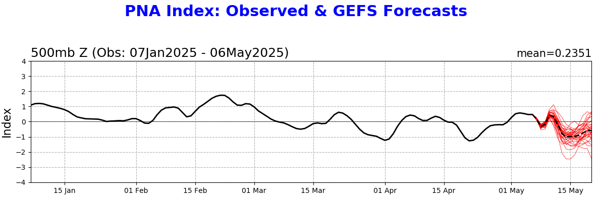
Where's @Typhoon Tip This seems like an impressive dip in the PNA for mid-May, no? EPS is even more negative too