weatherwiz
-
Posts
81,150 -
Joined
-
Last visited
Content Type
Profiles
Blogs
Forums
American Weather
Media Demo
Store
Gallery
Everything posted by weatherwiz
-
Sun out here, turning into a decent late afternoon
-
Yup some nice cells. Told me friend who lives in NW NJ yesterday they could see an upgrade to slight today with some tornado potential.
-
I would mind living near MAF for like April/May/early June
-
The outflow and gust front meant business. I think I've read some accounts from some of the SNE wx pages of people saying how chilly it felt with the outflow and gust front. With the way the storms were were aligned and tracking its possible maybe you had a couple localized areas where the outflows interacted and produced some brief, but intense straight-line winds.
-
Gotta say...the Euro from late last week anyways did a damn good job at nailing the second half of the week here. The GFS was super aggressive with building in the high pressure. Euro sniffed out precip along the weak cold front sagging south Thursday.
-
That's what the regular season finale should be known as from 2025 for the Patriots
-
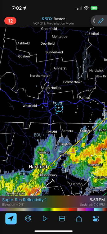
Looks like the axis of the most favorable parameters shifts quite a bit throughout the day. This is going to give alot of "false hope" for some because for the areas getting hit now and will later and the areas missing out...those areas missing out will eventually get it. Tomorrow is going to be interesting with a quite a bit of convective elements involved. PWATS are quite high for the entire region through tomorrow so just about everyone is going to get involved at some point.
-
I see the GFS with the first Atlantic cane of the season
-
This is a perfect time to be getting rain like this with full leaf out occurring and help get rid of the green crap everything is coated in.
-
Happy Birthday! I think the front sagged a bit farther south/east than guidance had early on and you had the prime differential heating boundary from SE NY and points northeast. Pretty good CAPE gradient too. Was able to maximize on the steep llvl lapse rates
-
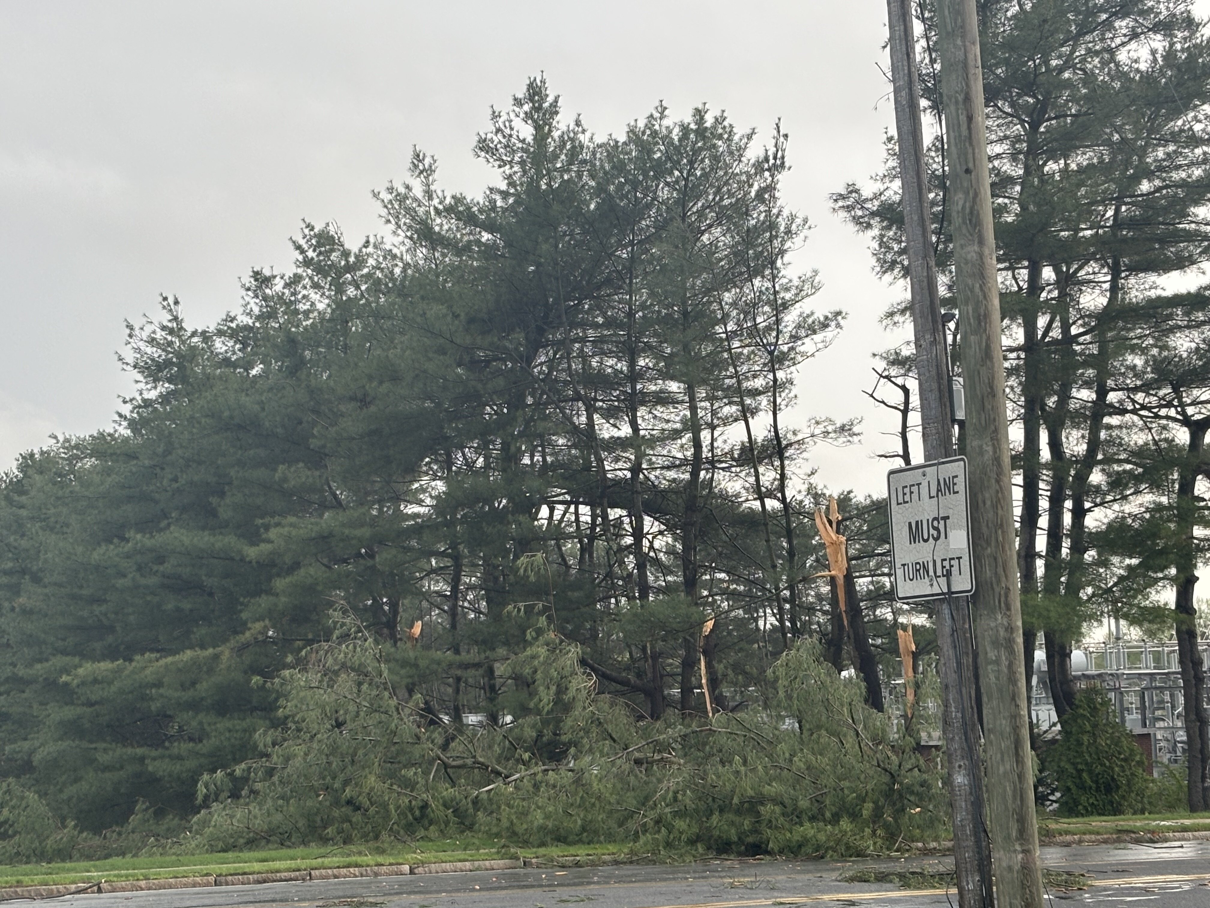
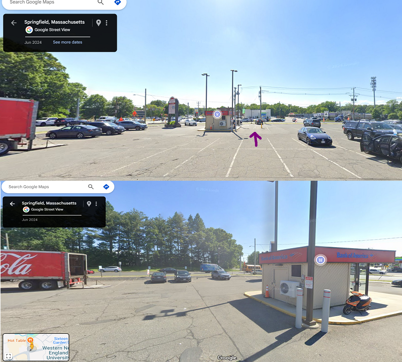
Here's the real thing which is better than what the video provides. I put an arrow in the spot I was in which points in the direction I'm facing. The bottom view is looking over to my left. So where those trees snapped was JUST out of my view. And actually...in the second pic if you see where those cars are parked, I was contemplating parking in those spots...I would have backed in and not be facing the trees but the circulation could have directly passed over my car...I also would have seen it coming from a farther distance because I would have had me head facing that direction. I could have gotten out of the car and film
-
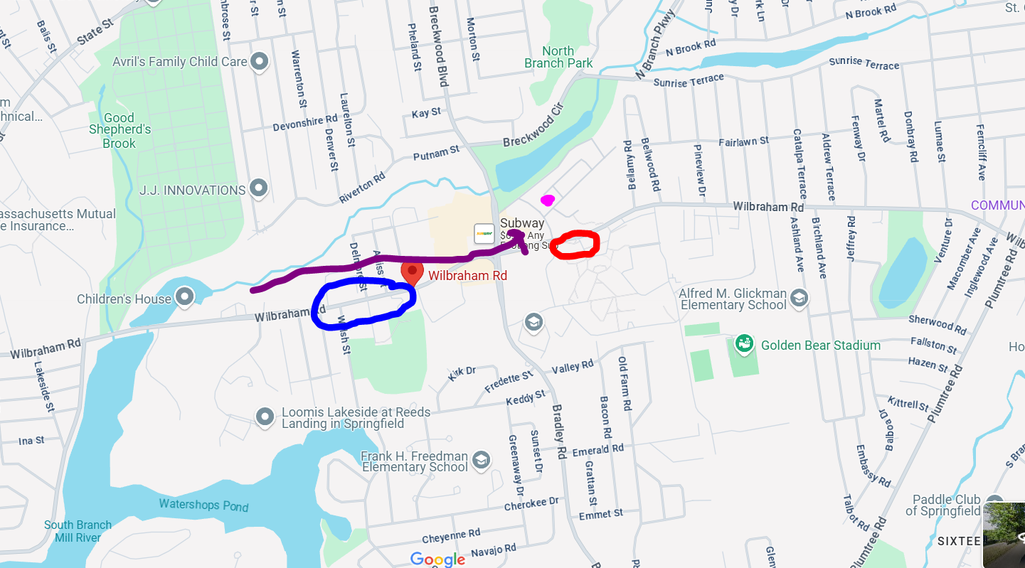
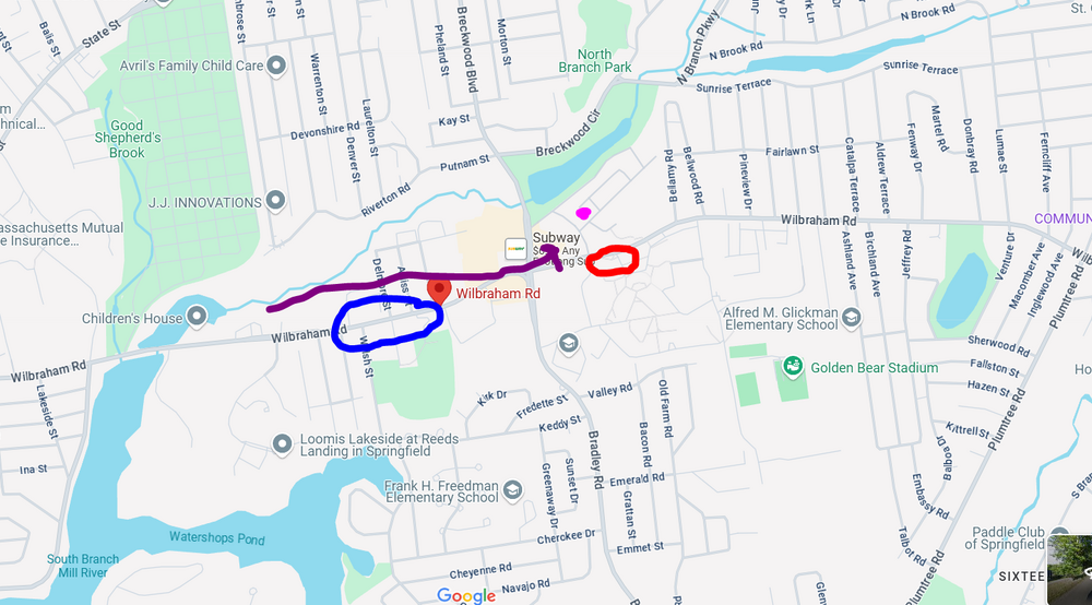
I suck at drawing but I did this. First off, I am not sure why google maps has the BoA ATM where it shows it but its where that gray box is. The trees snapped/damaged in the pic were at the end of the row so I wonder if the circulation ended up going diagonally? But I drew it from where I first saw it...probably once it passed my peripheral it slanted in track. But it definitely came straight down Wilbraham Rd because when I drove about 1/4 mile up the road, I couldn't go anymore because it was closed and I could see something on fire about another 1/4 up the road.

-
Thank you! Been a long time coming and perfect too…a weak tornado super close and there were no injuries!!
-
Thanks for the feedback, much appreciated. Here is a bit of a closer look from the damage which was where I was at. This marked the end of the damage too. but I don’t believe the circulation crossed on that side of the street…it crossed right in the parking lot I was in or maybe on the sidewalk. I can see if I can do a street view on google maps

-
I've been going back and forth with one of the skywarn guys and he's also gotten several other accounts from the area and said this also produced some damage in Ware. Unfortunately, due to the limited staffing there probably won't be any surveying and I'm not sure what exactly goes into the process to verify outside of a survey. But based on everything presented so far, this certainly could be classified as an EF0 tornado.
-
I think it was like 4:10-4:12
-
I only got to see it for seconds. I saw it coming from over the bank and then pass me. But if I was several parking spots to the right I wouldn't have had the bank obstructing that direction and I probably would have been able to see it come from up the road.
-
I wish now I was parked several spots over to my right...I wouldn't have had the building obstructing me, I could have maybe seen it coming from farther away. I still can't believe it...the lights flickering too just before it approached...very movie like.
-
This is great, thank you!
-
Just saw this. Where I was at the time is probably just a bit in the northwestern side of the location market
-
I wish I was able to go down the entire road to see where the damage began but it was closed off. The purple dot was where I was and the red circle is where there were pines down. The arrow shows the track. The blue circle is where the road was closed...I could see something on fire so it had started at least a good 1/2 mile up the road...but not sure what it was like going farther down
-
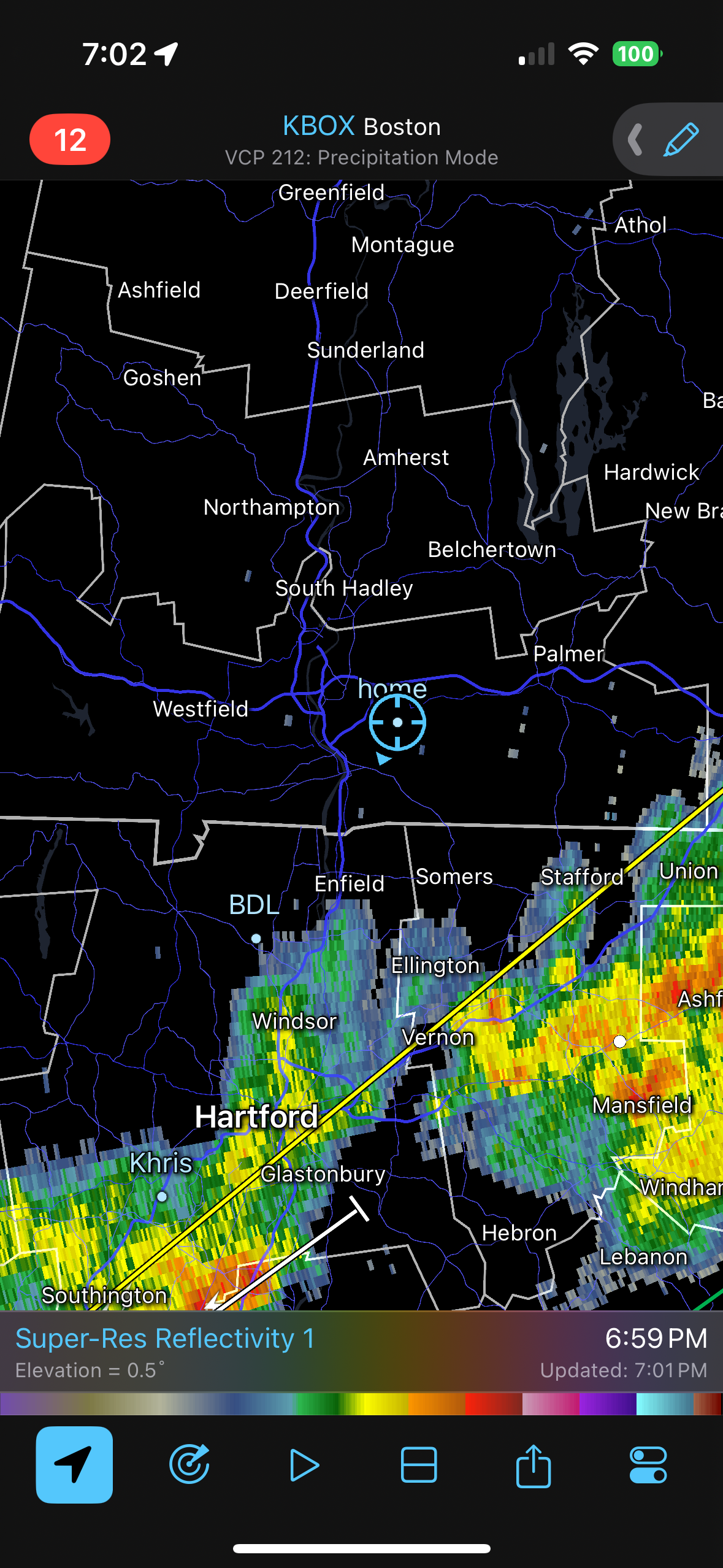
I still get torn because it happened just as the gust front is going through but it had to be just behind the gust front because precip had started. I'll have to pull back radar archives.
-
Trimmed the video. It happens about 40 seconds in. Like I said, I apologize for the camera disruptions early, I was relocating the camera. Still not sure if this is a gustnado or actual tornado. But whatever it was, I was at the end of its life as where I was at ended the damage.
-
ughh I hate YouTube. They always changing stuff. Video was not processing for some reason…or taking forever so I deleted and am trying again
-
I DID GET IT ON VIDEO!!!!! Uploading now. The entire video is like 15 minutes long but thankfully it happens within the first few minutes. Please excise some of the shakiness early on, I was relocating the camera and holding with one hand because my other hand was using phone for radar.