weatherwiz
-
Posts
79,817 -
Joined
-
Last visited
Content Type
Profiles
Blogs
Forums
American Weather
Media Demo
Store
Gallery
Everything posted by weatherwiz
-
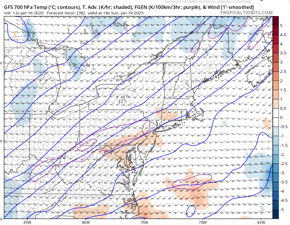
 Have to see what bufkit shows around noon but ratios could be extremely good. I would have to think, at least under the banding, we could push anywhere from 15:1 to 20:1. Talking about highest ratios here...obviously will differ probably towards the coast.
 -
Very nice (this is in northeast CT ish). I'm looking at national map so not zoomed in.
-
yeah I was able to see that with Scott's suggestion of clicking radar (rain/frozen) versus MSLP + radar.
-
some pretty good llvl inflow with strengthening llj. Going to see a pretty solid band if that verifies.
-
ahh makes sense. I would prefer to see more though than QPF but I would hope this is an encouraging signal for fronto potential at 78hr
-
Weird, hours 84-96 are grayed out for me on TT
-
I have a feeling Sunday night is going to surprise. You have some nice PVA feeding in and we're on the nose of a pretty strong 500mb jet streak. There should be some great frontogenesis over the region too. This would be one where I think the heaviest banding of snow would be farther northwest than models indicate and there is a nice inverted trough feature. I think this could evolve into a 3-6" type event for much of the region and maybe as much as 6-9" where heaviest banding traverses.
-
What's going to happen is we're going to get into the second half and February and first half of March and have all kinds of potential...but it will be interior/elevation that ends up cashing in. It will be the period where we're all hooting and hollering, "If only we got this setup x number of weeks ago".
-
euro still has Sunday night. Could see a nice heavy band evolve well northwest of the center, albeit narrow.
-
Very intriguing period for sure.
-
I do miss the times when discussions were more serious and the banter and emotional contributions would be at a minimum. I get everyone is fed up and all but like I said above, alot of the serious discussions get diluted and quickly because emotions start flying around. Maybe there should be some threads that are just designated to serious discussion - I know that's what the storm threads are for but a thread where you can bounce around ideas and principles. If you have anyone reading that is in college or maybe high school with a strong interest in meteorology - this place is second to none with knowledge and information. I know for myself, there is no way in hell I would be where I am today without what I have acquired and gained from the board over the years.
-
I get that but sometimes it bleeds into great discussion. There are probably lots of people who read (but don't post or post much) who are really trying to learn and understand more. This is a phenomenal source for learning and understanding the weather but it gets diluted at times.
-
How do you think I feel in the Summer I make a thread for convection...just general thunderstorms with maybe a rogue severe storm or two and everyone is screaming bust because there are no EF3s or widespread destructive winds or widespread hail...NO SHIT....never said there was going to be.
-
Just saw the 12z euro...that makes more sense to me then what the GFS was doing. Long ways out but this reminds me of (2 winters ago...maybe 3) when they had the series of winter storms across the deep South and we got one to come up the coast. Sure the look is suppressed well into the Gulf Coast but I love how the baroclinic zone is setup off the coast. Count me as intrigued around the 23rd.
-
Something tells me the GFS is too far south and east with next week. I would bet ensembles are geared farther northwest
-
That is an extremely concerning look for the deep South next week, both GFS and Euro.
-
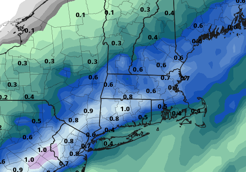
and an attached snow map
-
I am hoping that we kind of reset this pattern...not lose the pattern outright or go through a full out change but just relax it a bit with a few tweaks and then try again late month and February.
-
When I look at the GFS all I see are ghosts.
-
I mean more southern stream involvement, with a less dominant northern stream.
-
This is precisely why I want to try our luck with the southern stream. I'll be happy to go back to northern stream once we get a good atmospheric shakeup going. This regime we've been in just seems awful to get much help from the northern stream. I we can tell ourselves "just keep giving me chances" to make us feel better but that isn't going to change reality and the reality right now is its is giving us dog ****. I'm down to try something new for a while. If that sucks too...well then I quit.
-
I'm getting fed up with this northern stream crap. Its akin to Aaron Judge in the playoffs in big situations. You want him out there because you know he can perform, but ultimately you know you're just going to see a whiff and when it looks like it may deliver...it just drops the ball
-
The Patriots sucked, the Bruins are awful, the Celtics I guess will be fine, the Red Sox off-season has been another slap in the face, winter has been boring beyond belief....MAKE IT STOP!!!! Can we just fastforward to when there is a storm at D3 and skip this boring crap.
-
New England Winter 2024-25 Bantering, Whining, and Sobbing Thread
weatherwiz replied to klw's topic in New England
We should plan a g2g at one of these games
-
I am with you on the "you would think approach". I try not to think like that or present that anymore. You're right though. And the most difficult part of all this is trying to tie climate change, whether it be locally, regionally, or globally. What becomes even more difficult is we can only work with data we have and in a large sense, the sample sizes are small and alot of data is reconstructed so there needs to be some caution with how that data is being used and compared. When I was heavily tacking ENSO composites a few years back, I was incorporating the Ensemble ONI and reading alot of the work Eric Webb and others had done with ENSO. When alot of people talk about ENSO everything is geared towards the CPC ONI but there is a while other world of ideas and methodologies on ENSO. The Ensemble ONI re-constructed ENSO events back to like the 1860's or maybe 1830's. I only went back to 1900 when doing composites but one thing I really noticed was (and there has been lots of literature on this) is how the behavior of ENSO events have changed since about the 1970's or 1980's. If you look at individual events and compare to a long-term mean, there are some striking differences in behavior. But what does this really mean? At the end of the day, at least with ENSO, we will continue to witness behaviors that go against the mean but is that for a specific reason or is it because it's just another playing card we haven't seen before? Regardless though there is certainly some influence on climate change going on, it's just how big of an influence is it? I mean all you have to do is go back to the basics of atmospheric physics, atmospheric chemistry, and meteorology 151 to understand and see this. Wildfire smoke and volcanic eruptions have to play some sort of roll too, all those chemicals being emitted into the atmosphere, especially if these chemicals are being entrained into the stratosphere. This would surely have an impact on ozone production or depletion. Obviously we've gone through some brutal snow drought periods before and one of those is the 80's which is often referenced. But I guess at the end of the day we need to look at, what was the driver behind those periods and how does it compare to what is going on now?