Ralph Wiggum
-
Posts
17,383 -
Joined
-
Last visited
Content Type
Profiles
Blogs
Forums
American Weather
Media Demo
Store
Gallery
Everything posted by Ralph Wiggum
-

Blizzard of 2026 Storm Thread/OBS
Ralph Wiggum replied to Mikeymac5306's topic in Philadelphia Region
BOOM! Upgraded to a warning. Second I shut my eyes the alert starts going off. Ha! -
Blizzard of 2026 Storm Thread/OBS
Ralph Wiggum replied to Mikeymac5306's topic in Philadelphia Region
40" at ACY. Might need a casino run. -
Blizzard of 2026 Storm Thread/OBS
Ralph Wiggum replied to Mikeymac5306's topic in Philadelphia Region
3k is settling me down. 50 miles west with the slp. Yeah, enough models for tonight. G'night -
Blizzard of 2026 Storm Thread/OBS
Ralph Wiggum replied to Mikeymac5306's topic in Philadelphia Region
Which is ok farther N into NYC where u are as it gives time to recover, but its a tightrope down here west of i95. Still looks good for a plowable event here for now. -
Blizzard of 2026 Storm Thread/OBS
Ralph Wiggum replied to Mikeymac5306's topic in Philadelphia Region
Looping last 3 runs at 48hrs on the 6z the slp is 100 miles farther east. Thats not an hallucination. -
Blizzard of 2026 Storm Thread/OBS
Ralph Wiggum replied to Mikeymac5306's topic in Philadelphia Region
I saw, but leading to that point clearly is showing how fragile this is and how the euro could be getting a handle on the evolution. Maybe im wrong. -
Blizzard of 2026 Storm Thread/OBS
Ralph Wiggum replied to Mikeymac5306's topic in Philadelphia Region
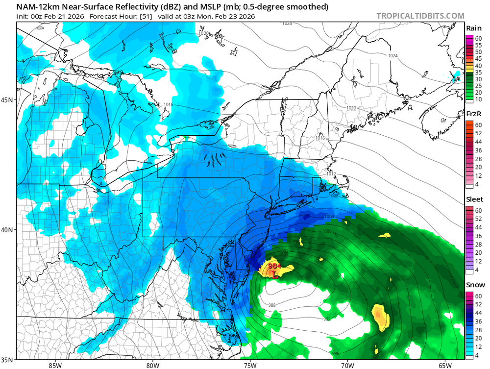
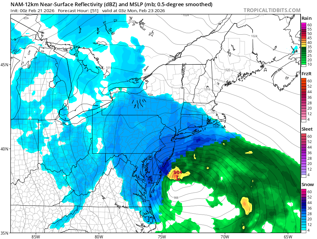
Rather significant jump east. Misses the capture and tug west to keep it tucked, thus escapes east and grazes the shore. Lol, cant make this stuff up. I dont think this is just windshield wiper stuff either this is a different synoptic entirely. -
Blizzard of 2026 Storm Thread/OBS
Ralph Wiggum replied to Mikeymac5306's topic in Philadelphia Region
6z NAM 12k will also be east and less snow. Avg event this run and back down to earth. -
Blizzard of 2026 Storm Thread/OBS
Ralph Wiggum replied to Mikeymac5306's topic in Philadelphia Region
HRDPS jumped east and will be a scraper. -
E PA/NJ/DE Spring 2026 Obs/Discussion
Ralph Wiggum replied to PhiEaglesfan712's topic in Philadelphia Region
Another weenie gfs run. This doesnt appear to be the end just yet. -
Blizzard of 2026 Storm Thread/OBS
Ralph Wiggum replied to Mikeymac5306's topic in Philadelphia Region
Some nonsense about telleconnections not being right for a big storm -
Blizzard of 2026 Storm Thread/OBS
Ralph Wiggum replied to Mikeymac5306's topic in Philadelphia Region
How dafuq is Hurricane saying this will be a fast mover without major impact? Has the man lost his mojo or will he score the win here?? -
Blizzard of 2026 Storm Thread/OBS
Ralph Wiggum replied to Mikeymac5306's topic in Philadelphia Region
Seriously! Old red needs to find a way to nap on Sunday. -
Blizzard of 2026 Storm Thread/OBS
Ralph Wiggum replied to Mikeymac5306's topic in Philadelphia Region
So help me if we get March 2001'd.....I cannot handle this twice in my lifetime. -
Blizzard of 2026 Storm Thread/OBS
Ralph Wiggum replied to Mikeymac5306's topic in Philadelphia Region
RGEM ticked east if we are being honest. Noise? -
Blizzard of 2026 Storm Thread/OBS
Ralph Wiggum replied to Mikeymac5306's topic in Philadelphia Region
I wish this were 6 hours away and not 36....just saying -
Blizzard of 2026 Storm Thread/OBS
Ralph Wiggum replied to Mikeymac5306's topic in Philadelphia Region
10? Bro, this might be a lifetime storm for a good chunk of this subforum. -
Blizzard of 2026 Storm Thread/OBS
Ralph Wiggum replied to Mikeymac5306's topic in Philadelphia Region
That is blizzard 83 type shit but times 2 if not 3. What the serious fuck is happening?!.! -
Blizzard of 2026 Storm Thread/OBS
Ralph Wiggum replied to Mikeymac5306's topic in Philadelphia Region
Dear God I just looked. Pants tent warning! -
Blizzard of 2026 Storm Thread/OBS
Ralph Wiggum replied to Mikeymac5306's topic in Philadelphia Region
Im sending laughing emoji because thisnis sheer insanity....and Im also buzzed pretty good. -
Blizzard of 2026 Storm Thread/OBS
Ralph Wiggum replied to Mikeymac5306's topic in Philadelphia Region
Mike, when I see you posting like this, I k ow this shit is about to get real. Guys, this is going to end up the storm of a lifetime for many nearby in our region. I dont think there is any way to sugarcoat it at this point. -
Blizzard of 2026 Storm Thread/OBS
Ralph Wiggum replied to Mikeymac5306's topic in Philadelphia Region
Tucked