Ralph Wiggum
-
Posts
17,384 -
Joined
-
Last visited
Content Type
Profiles
Blogs
Forums
American Weather
Media Demo
Store
Gallery
Everything posted by Ralph Wiggum
-

Blizzard of 2026 Storm Thread/OBS
Ralph Wiggum replied to Mikeymac5306's topic in Philadelphia Region
Met in a different sub states 0z and 6z suites were actually steps back from 18z yesterday -
Blizzard of 2026 Storm Thread/OBS
Ralph Wiggum replied to Mikeymac5306's topic in Philadelphia Region
Wow on the euro. Hold its ground. Less than an inch most of South Jersey where the GFS has 3 feet in spots. The pros say go with the Euro. I say go with the least snowiest model. I think we all.know inside how this will play out, let's not kid ourselves. Its been fun tho. -
Blizzard of 2026 Storm Thread/OBS
Ralph Wiggum replied to Mikeymac5306's topic in Philadelphia Region
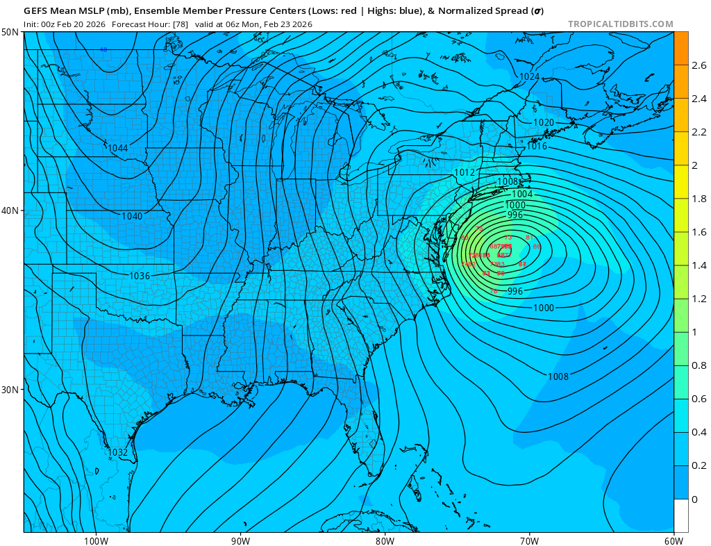
This isnt one of those Miller storms with a wide swath of heavy snow. Rather this is a tight core of ccb making this a forecasting nightmare between a gfs solution and a nudge east and a bust. The margin for error is extremely small. -
Blizzard of 2026 Storm Thread/OBS
Ralph Wiggum replied to Mikeymac5306's topic in Philadelphia Region
I feel like if we follow the Euro-NAM least snowy thing we are setting up for a surprise. Then I feel like if we go with the GFS we get the March 2001 rug pull. I suppose ICON middle of the road is the way to go with del and NJ being the jack zone. -
Blizzard of 2026 Storm Thread/OBS
Ralph Wiggum replied to Mikeymac5306's topic in Philadelphia Region
All 3 of those tighten the system and because of the cleaner phase keep the good qpf well south and east though. Not sure we want a clean phase unless it happens alot sooner and farther NW. If you want the possible big dog then yes, full clean phase. If you want guaranteed low end SECS then roll the dice with more separation and the PVA precip followed by the ull/ivt stuff. What i dont like about the full clean phase is we increase the chances significantly for a rug pull last minute. Tho i suppose thats the chance we take when rooting for a big dog always. -
Blizzard of 2026 Storm Thread/OBS
Ralph Wiggum replied to Mikeymac5306's topic in Philadelphia Region
Let's be real, this is only less than a 6 hour timing difference wrt the 2 shortwaves between being a GFS tucked bomb or a NAM March 2001 rug pull. I will forever have ptsd from that storm and I am getting similar vibes. I am strongly urging cautious optimism from everyone because 1) we still dont have unanimous agreement 2) if the euro isnt biting its probably right and 3) always go with the least snowiest model. Not trying to deb, but alot of us, especially me included, can let emotions take hold. GFS doubled down again but could it be completely wrong and the slp escape east? You better believe that scenario is possible. Ive seen the gfs hold until 12 hours prior before....it can be stubborn. -
Blizzard of 2026 Storm Thread/OBS
Ralph Wiggum replied to Mikeymac5306's topic in Philadelphia Region
-
Blizzard of 2026 Storm Thread/OBS
Ralph Wiggum replied to Mikeymac5306's topic in Philadelphia Region
I was wondering where tf you got to -
Blizzard of 2026 Storm Thread/OBS
Ralph Wiggum replied to Mikeymac5306's topic in Philadelphia Region
Precip shield expanded NW interestingly enough. Yes im talking to myself. Dont judge me -
Blizzard of 2026 Storm Thread/OBS
Ralph Wiggum replied to Mikeymac5306's topic in Philadelphia Region
Looks a tick east aside from 1 or 2 slp centers that held no? -
Blizzard of 2026 Storm Thread/OBS
Ralph Wiggum replied to Mikeymac5306's topic in Philadelphia Region
So euro-nam rule vs the gfs? Are we still following Hurricane Schwartz' advice.and siding with the superior Euro and just tossing the GFS? -
Blizzard of 2026 Storm Thread/OBS
Ralph Wiggum replied to Mikeymac5306's topic in Philadelphia Region
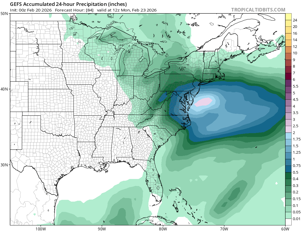
GFS: -
Blizzard of 2026 Storm Thread/OBS
Ralph Wiggum replied to Mikeymac5306's topic in Philadelphia Region
So euro has an inch in some areas the gfs has 30. Ok. -
Blizzard of 2026 Storm Thread/OBS
Ralph Wiggum replied to Mikeymac5306's topic in Philadelphia Region
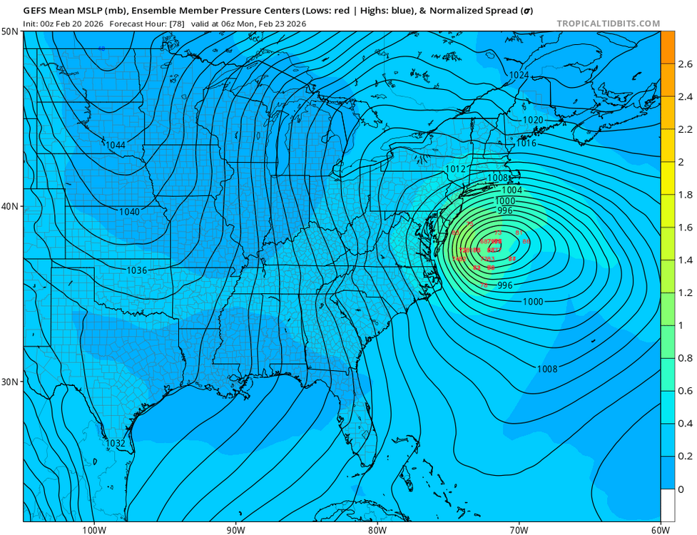
Gefs mean is around 6.5" imby. Thats pretty sweet. -
Blizzard of 2026 Storm Thread/OBS
Ralph Wiggum replied to Mikeymac5306's topic in Philadelphia Region
Thank you for your prettier maps ! -
Blizzard of 2026 Storm Thread/OBS
Ralph Wiggum replied to Mikeymac5306's topic in Philadelphia Region
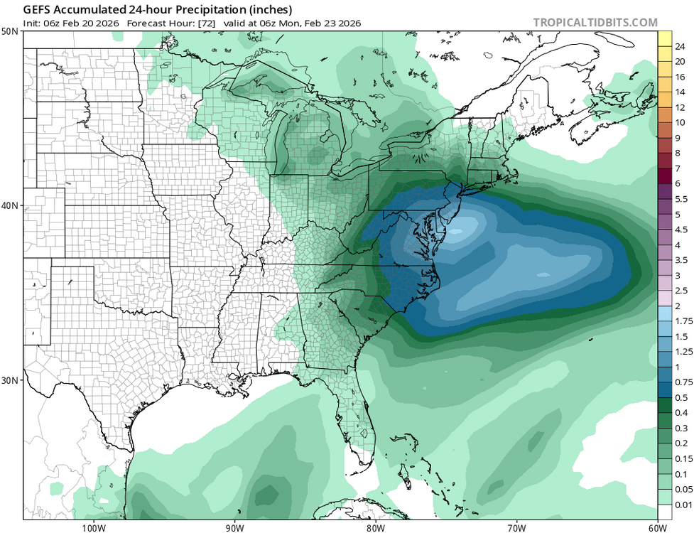
GEFS decent with a cluster west of the mean slp. Hold! Eta: qpf also increased se pa decent tick up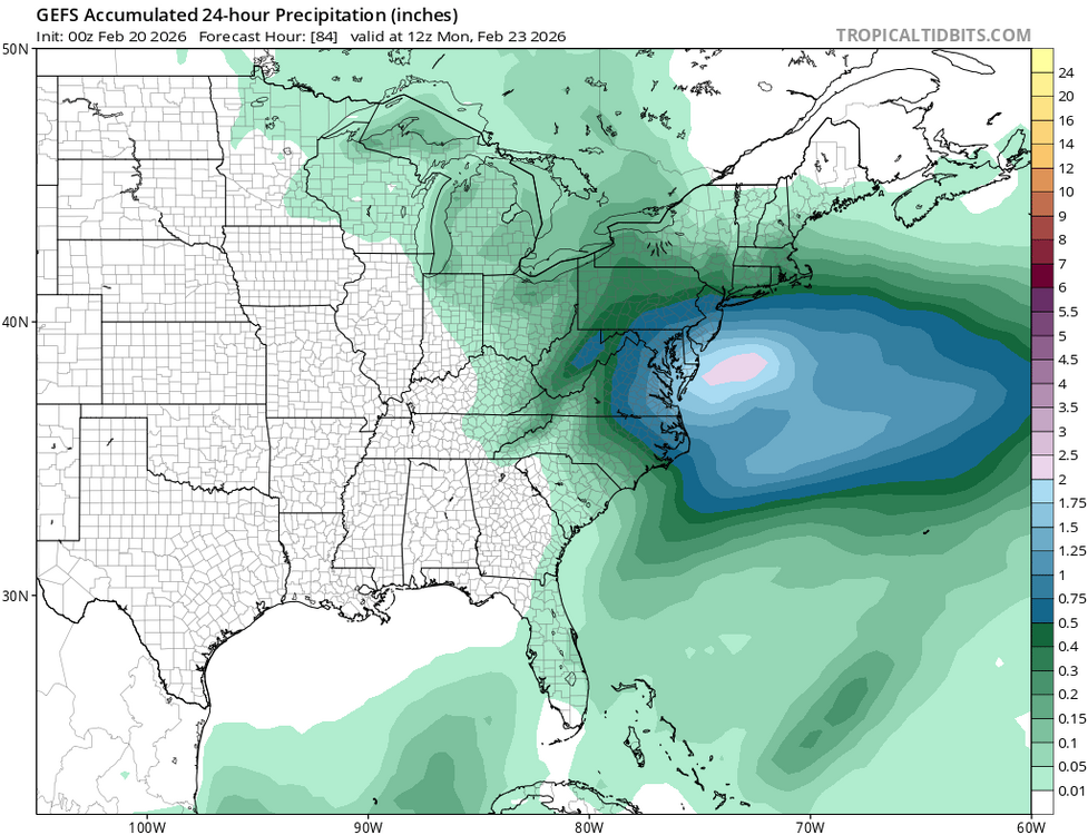
-
Feb 22nd/23rd "There's no way..." Storm Thread
Ralph Wiggum replied to Maestrobjwa's topic in Mid Atlantic
CMC wants to give a nod to the gfs -
Feb 22nd/23rd "There's no way..." Storm Thread
Ralph Wiggum replied to Maestrobjwa's topic in Mid Atlantic
You guys in DC land (and others) deserve this and I am fucking pulling for y'all. Not only a warning event but a HECS AND you finally might but a blip in the void of late feb no snow land. LFG -
Blizzard of 2026 Storm Thread/OBS
Ralph Wiggum replied to Mikeymac5306's topic in Philadelphia Region
Aaaaand the GFS holds serve. Wtf! -
Blizzard of 2026 Storm Thread/OBS
Ralph Wiggum replied to Mikeymac5306's topic in Philadelphia Region
Seems like most guidance is honing in on a coastal hit for parts of DE and S NJ with lighter stuff N and W. Im sure we will have more wobbles but the general idea of extreme S Jersey being the jack zone seems pretty solid right now. -
Feb 22nd/23rd "There's no way..." Storm Thread
Ralph Wiggum replied to Maestrobjwa's topic in Mid Atlantic
We blame convective feedback. Weenie handbook chapter 6 section 2 titled "but the low should be closer to the coast shouldn't it?". -
Feb 22nd/23rd "There's no way..." Storm Thread
Ralph Wiggum replied to Maestrobjwa's topic in Mid Atlantic
Is a lottle more than a little? Like a 'lot' better? -
Feb 22nd/23rd "There's no way..." Storm Thread
Ralph Wiggum replied to Maestrobjwa's topic in Mid Atlantic
Fv3 at 60 isnt as diggy with the lead shortwave so the trailing one has more of a chance to catch it and phase. -
Feb 22nd/23rd "There's no way..." Storm Thread
Ralph Wiggum replied to Maestrobjwa's topic in Mid Atlantic
I was thinking that too. So.much separation between the waves heights actually rise in front of the trailing wave. I suppose that helps with the positive vorticity advection aspect but the full phase and capture is not on the 0z nam. -
Blizzard of 2026 Storm Thread/OBS
Ralph Wiggum replied to Mikeymac5306's topic in Philadelphia Region
Nice confluence as well. Alot of little pieces coming together.