CT Rain
-
Posts
26,302 -
Joined
-
Last visited
Content Type
Profiles
Blogs
Forums
American Weather
Media Demo
Store
Gallery
Everything posted by CT Rain
-

Active mid December with multiple event potential
CT Rain replied to Typhoon Tip's topic in New England
Maybe I’ll just double my paltry 6”-12” forecast and call it a day. -
Active mid December with multiple event potential
CT Rain replied to Typhoon Tip's topic in New England
That’s a nice ukie look -
Active mid December with multiple event potential
CT Rain replied to Typhoon Tip's topic in New England
Yup -
Active mid December with multiple event potential
CT Rain replied to Typhoon Tip's topic in New England
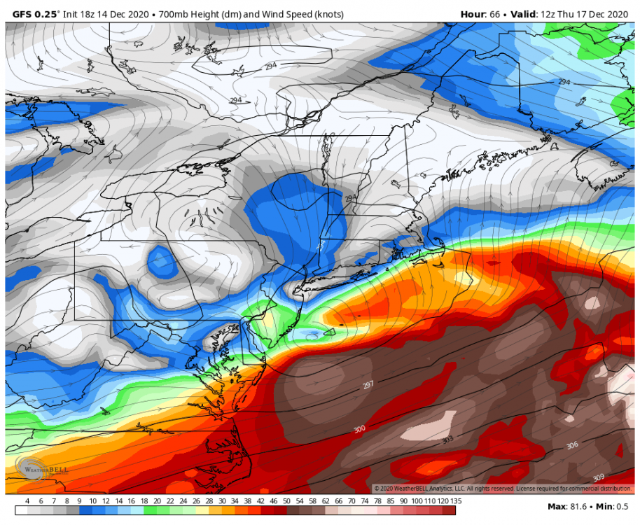
You can see why the GFS sh*ts the bed with the storm in SNE. 700mb low and warm conveyorbelt just falls apart. Not sure it's right but definitely a caution flag IMO.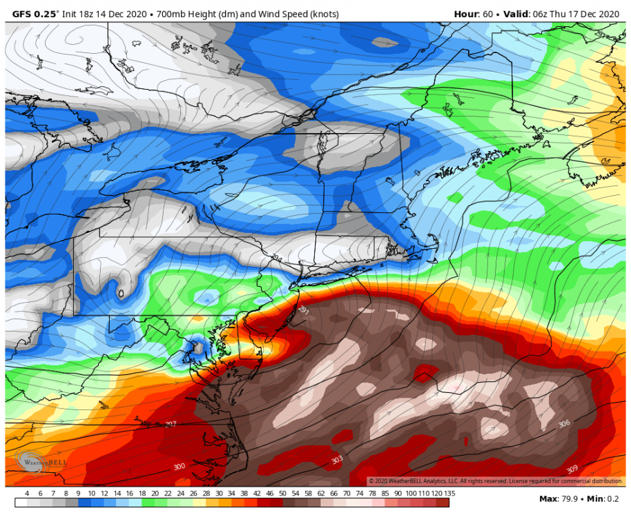
-
Active mid December with multiple event potential
CT Rain replied to Typhoon Tip's topic in New England
My biggest concern with the GFS is just how everything falls apart as it comes NE. Probably too much but I think a Euro/GFS blend makes sense. -
Active mid December with multiple event potential
CT Rain replied to Typhoon Tip's topic in New England
Storm really falls apart on the GFS once it gets into SNE. That s/w goes into the shredder. -
Active mid December with multiple event potential
CT Rain replied to Typhoon Tip's topic in New England
I mean it's possible. Some hellacious fronto. -
Active mid December with multiple event potential
CT Rain replied to Typhoon Tip's topic in New England
12km NAM is beautiful for the QPF Queens. I do think it's overdone with such a wide swath of that kind of liquid? Seems fairly progressive and not that classic ML lows closing off and pivoting right under us? -
Active mid December with multiple event potential
CT Rain replied to Typhoon Tip's topic in New England
Beast mode on the NAM. Pretty wild look there. -
Active mid December with multiple event potential
CT Rain replied to Typhoon Tip's topic in New England
I wonder if the s/w sort of damping out/getting sheared opens the door for non-hydrostatic stuff to start taking over with convection offshore. We'll have less and less forcing from DCVA as that s/w weakens over SNE but may see convection start running the show over the Gulf Stream and messing with the WCB and other stuff. -
Active mid December with multiple event potential
CT Rain replied to Typhoon Tip's topic in New England
I have a feeling there's going to be a pretty narrow band along the max fgen zone that gets slammed. I doubt it's nearly as widespread as the QPF queens would believe. I could see something like the 18z Euro (narrow band of really good stuff) and less on either side. Not sure, of course, where that band is. -
Active mid December with multiple event potential
CT Rain replied to Typhoon Tip's topic in New England
Yeah I think they were saying that as a reason that confidence is low. I think they changed it last year. They also got rid of Blizzard Watches -
Active mid December with multiple event potential
CT Rain replied to Typhoon Tip's topic in New England
There's actually no time limit anymore on the watches... just 50% confidence of reaching the criteria. -
Active mid December with multiple event potential
CT Rain replied to Typhoon Tip's topic in New England
There's a ton of spread on the GEFS so still a pretty uncertain forecast with respect to SNE impacts I think. Would like to see a couple jumps on the GEFS to the north.
-
Active mid December with multiple event potential
CT Rain replied to Typhoon Tip's topic in New England
Plenty of time for the north trend to commence. -
Unless the federal government steps up to pay bars/restaurants/etc to stay closed (which of course they should) and keep their employees whole I'm not sure what can be done.
-
Yeah, we're in a very bad place. There's also no appetite for shutdowns like we had in March which will make this that much harder. Thankfully outcomes are better with better treatments but man it's not going to pretty.
-
For sure. I mean everyone I know with an IKON or EPIC pass is 100% expecting to ski in VT this winter. Not even contemplating not going.
-
I'm willing to bet in a couple Fridays the endless stream of black SUVs with NY/NJ/CT plates will be racing up I-91. I can't imagine that the ski areas are expecting compliance with this otherwise why even open for the year? Have to imagine most of the revenue from the bigger resorts is from out of state guests who would not be able to quarantine in most situations.
-
-
Significant Severe Weather Event Possible Thursday, August 27, 2020
CT Rain replied to weatherwiz's topic in New England
Oh wow - figured it was bad. You can track the RFD surge from the Farm River in North Branford/Foxon right over Snake Hill and then down toward Tisko off Damascus Rd. Did you ever get your drone up? -
Significant Severe Weather Event Possible Thursday, August 27, 2020
CT Rain replied to weatherwiz's topic in New England
Yeah I imagine Snake Hill is an absolute mess. I'm also wondering how it is over by the Supply Ponds... the core of the strongest wind went from Snake Hill right over the Supply Ponds and then down through Damascus Rd near Tisko. Let me know what you see - I'd love to take a look! -
Significant Severe Weather Event Possible Thursday, August 27, 2020
CT Rain replied to weatherwiz's topic in New England
I was out on the Sound Sunday and saw the damage from the water. The most impressive damage was just west of you over the Thimbles where there were a number of snapped flag poles, snapped/uprooted trees, etc. Lots of debris in the water including flipped over docks, limbs, etc. What a mess. Glad you're OK. -
Significant Severe Weather Event Possible Thursday, August 27, 2020
CT Rain replied to weatherwiz's topic in New England
I drove around Branford yesterday and the damage is remarkable. Widespread 80-100 mph gusts with snapped stands of hardwood trees, some structural damage, etc. Have to imagine it's the worst damage in town since at least Hurricane Gloria. What struck me overall was the pretty much continuous damage path from Bethany to Hamden to North Haven and then North Branford/Foxon/Branford. One of the most impressive swaths of widespread damage I can recall outside of a significant tornado in New England. -
Significant Severe Weather Event Possible Thursday, August 27, 2020
CT Rain replied to weatherwiz's topic in New England
It was in time for Branford but definitely late for Bethany and Hamden.