

CT Rain
-
Posts
26,253 -
Joined
-
Last visited
Content Type
Profiles
Blogs
Forums
American Weather
Media Demo
Store
Gallery
Everything posted by CT Rain
-
Midday newscasts are tough to make wholesale changes unless it's a real short term thing. No point in jumping on things before the full suite of 12z guidance and ensembles is in.
-
lol
-
With a MAUL above and below. We take.
-
Also super nice snow growth along that mid level warm front from I-84 corridor up toward Ray.
-
I wonder if it's better to just ditch Sunday and see what we can do with the Monday/Tuesday s/w.
-
EPS snow probs aren't great but the op is certainly juicy.
-
You in Worcester tonight?
-

Watching closely .. February 1-3rd for moderate to major coastal event
CT Rain replied to Typhoon Tip's topic in New England
Gotta be concerned for spring water table issues at this rate. Brush fires on the Massif? -
Watching closely .. February 1-3rd for moderate to major coastal event
CT Rain replied to Typhoon Tip's topic in New England
Hires NAM with ~0.4" of QPF for Tolland.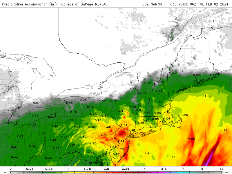
-
Watching closely .. February 1-3rd for moderate to major coastal event
CT Rain replied to Typhoon Tip's topic in New England
Here's our running forecast. Best chance for highest totals locally is in W CT I think. I do think a pretty prolonged period of junk with the dry slot south and east of I-84 so a lot of snow grains, freezing drizzle, and sleet. -
Watching closely .. February 1-3rd for moderate to major coastal event
CT Rain replied to Typhoon Tip's topic in New England
700mb track on euro definitely pretty funky. Brings it all the way west into C NJ -
Watching closely .. February 1-3rd for moderate to major coastal event
CT Rain replied to Typhoon Tip's topic in New England
Let's get another shuffle east with it! -
Watching closely .. February 1-3rd for moderate to major coastal event
CT Rain replied to Typhoon Tip's topic in New England
700mb track definitely a bit more favorable. Keeps the dry slot shunted farther SE. -
Watching closely .. February 1-3rd for moderate to major coastal event
CT Rain replied to Typhoon Tip's topic in New England
I mean if we can get that 700 low a bit farther S&E when it stalls out it would be epic for SNE. -
Watching closely .. February 1-3rd for moderate to major coastal event
CT Rain replied to Typhoon Tip's topic in New England
the NAM would be unreal for NYC and especially suburbs just N&W with that 700mb low stall. -
Watching closely .. February 1-3rd for moderate to major coastal event
CT Rain replied to Typhoon Tip's topic in New England
Time to disrobe for the NAM -
Watching closely .. February 1-3rd for moderate to major coastal event
CT Rain replied to Typhoon Tip's topic in New England
Yes, though I have definite concerns with dry air advecting south in the boundary layer through W Mass and N CT. The Euro keeps pretty high sfc dew point depressions through the event. -
Watching closely .. February 1-3rd for moderate to major coastal event
CT Rain replied to Typhoon Tip's topic in New England
Looks like <0.5" QPF for Tolland. -
Watching closely .. February 1-3rd for moderate to major coastal event
CT Rain replied to Typhoon Tip's topic in New England
We take that.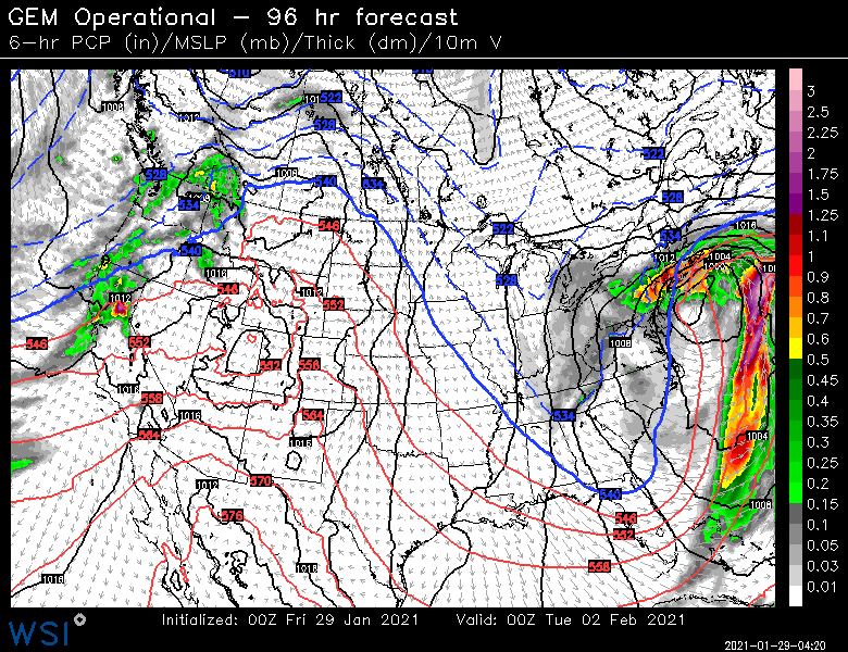
-
Watching closely .. February 1-3rd for moderate to major coastal event
CT Rain replied to Typhoon Tip's topic in New England
Sure is -
Watching closely .. February 1-3rd for moderate to major coastal event
CT Rain replied to Typhoon Tip's topic in New England
GFS v16 is not enthusiastic! -
We take that solution.
-
NAM and GFS. Euro as well for a period of time Tuesday night..., though it looks better by 12z Wednesday.
-
EPS QPF probabilities are pretty impressive for the Mon/Tue event. Anyone have any thoughts on timing? Likely to be slower or faster than currently progged?
-
The snow growth zone dries out pretty quickly Tuesday night. Something to keep an eye on - may wind up with some sleet or even freezing rain Wednesday AM south of the Pike.


