CT Rain
-
Posts
26,257 -
Joined
-
Last visited
Content Type
Profiles
Blogs
Forums
American Weather
Media Demo
Store
Gallery
Everything posted by CT Rain
-

Preliminarily ... a medium impact partial Miller B, Friday
CT Rain replied to Typhoon Tip's topic in New England
I'm struggling there. I wasn't even being a jerk to Kevin... just seems like longitude may hurt by 1 or 2F compared to Litchfield Co. -
Preliminarily ... a medium impact partial Miller B, Friday
CT Rain replied to Typhoon Tip's topic in New England
Yeah the map has warning criteria snow for one town. They never normally issue warnings for the whole county when that happens so idk what that's all about. -
Preliminarily ... a medium impact partial Miller B, Friday
CT Rain replied to Typhoon Tip's topic in New England
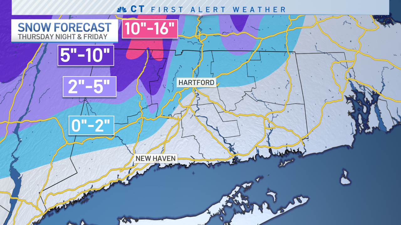
This is their snow map. -
Preliminarily ... a medium impact partial Miller B, Friday
CT Rain replied to Typhoon Tip's topic in New England
First cut pending the 18z NAM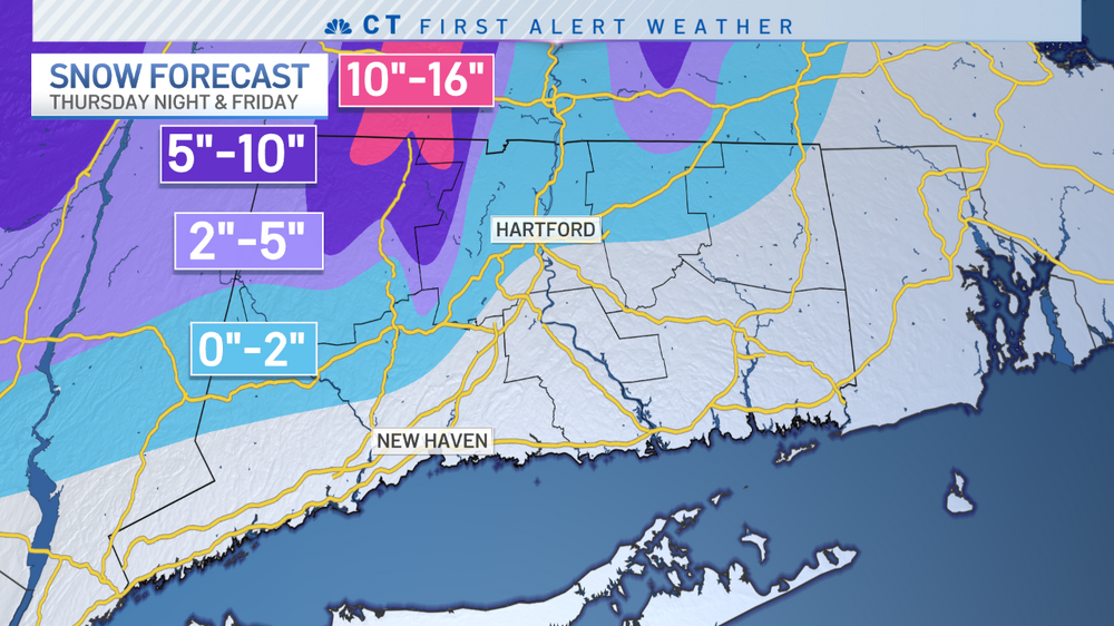
-
Preliminarily ... a medium impact partial Miller B, Friday
CT Rain replied to Typhoon Tip's topic in New England
I agree. I think 6-12 is a good bet in that area. -
Preliminarily ... a medium impact partial Miller B, Friday
CT Rain replied to Typhoon Tip's topic in New England
INteresting to see the snow probabilities from the NBM and WPC be so low too. Basically <10% chance of >1" of snow for Tolland/Union. Even NW CT is pretty low. -
Preliminarily ... a medium impact partial Miller B, Friday
CT Rain replied to Typhoon Tip's topic in New England
Yeah it's close. Was thinking the easterly flow probably hurts him a bit compared to NW CT. Even the hires models (3km NAM/HRRR) are a good 2F cooler at 2m to the west. Seems like some longitude assist WOR. -
Preliminarily ... a medium impact partial Miller B, Friday
CT Rain replied to Typhoon Tip's topic in New England
Think the boundary layer is cold enough even for Kev? Litchfield County looks good to me but the soundings EOR not looking great to me right now. -
Preliminarily ... a medium impact partial Miller B, Friday
CT Rain replied to Typhoon Tip's topic in New England
Yeah it can't go too crazy given the upper level setup. Not like we're getting a crazy bomb that's closing off at 500mb. It's sort of a SWFE with some redevelopment off the coast. -
Preliminarily ... a medium impact partial Miller B, Friday
CT Rain replied to Typhoon Tip's topic in New England
Will be an interesting event for sure. Something a bit more dynamic with that op GFS track would be fun. -
Preliminarily ... a medium impact partial Miller B, Friday
CT Rain replied to Typhoon Tip's topic in New England
My worry with that is they're just weaker which isn't really great either. Not sure the op GFS would get it done with a weaker and more strung out system. -
Preliminarily ... a medium impact partial Miller B, Friday
CT Rain replied to Typhoon Tip's topic in New England
Yeah you can see that on the model 2m temps... there's definitely a bit of longitude assist there. I think Litchfield Hills and Berkshires will do very well being a bit farther west plus some upslope assist/cooling. -
Preliminarily ... a medium impact partial Miller B, Friday
CT Rain replied to Typhoon Tip's topic in New England
That's close to a pounding for the valley too around here. -
Preliminarily ... a medium impact partial Miller B, Friday
CT Rain replied to Typhoon Tip's topic in New England
Sure does -
Preliminarily ... a medium impact partial Miller B, Friday
CT Rain replied to Typhoon Tip's topic in New England
NW CT and Berkshires may get hit hard. Not sure it'll work east of there with all that easterly flow. -
Preliminarily ... a medium impact partial Miller B, Friday
CT Rain replied to Typhoon Tip's topic in New England
Actually colder here in the Valley then on Mount Tolland! -
Preliminarily ... a medium impact partial Miller B, Friday
CT Rain replied to Typhoon Tip's topic in New England
NAM is a pretty impressive paste bomb around here -
Agree with this. Definitely need something stronger to be a fun event for the masses.
-
Thinking about Mount Snow Saturday as long as the Friday system doesn't turn into a fiasco.
-
Yeah next week looks interesting
-
EPS looks a bit warmer and more tugged in compared to 00z.
-
Yeah I'm tentatively planning Mount Snow on Saturday.
-
Is it wrong that I'd rather a hugger/cutter than a suppressed storm that crushes DC?
-
The GGEM is sort of a SWFE. Gets accumulating snow in before the changeover even around here.
-
Yeah - going to be pretty tough for many in SNE unless we see some fairly big changes. There's just not a lot of cold to work with as it looks now.