

CT Rain
-
Posts
26,264 -
Joined
-
Last visited
Content Type
Profiles
Blogs
Forums
American Weather
Media Demo
Store
Gallery
Everything posted by CT Rain
-

Thursday, July 27, 2023 Severe Weather Potential
CT Rain replied to weatherwiz's topic in New England
The soundings on the NAM and Euro remain extremely impressive tomorrow across SNE. HRRR a bit less so but we certainly could see a few spinners and maybe even a sig tor if things break right. -
Thursday, July 27, 2023 Severe Weather Potential
CT Rain replied to weatherwiz's topic in New England
lol what a disaster that was -
July has arrived ... the Meteorologically defined mid summer month
CT Rain replied to Typhoon Tip's topic in New England
LCLs are extremely low on that sounding. -
July has arrived ... the Meteorologically defined mid summer month
CT Rain replied to Typhoon Tip's topic in New England
The NWS uses it to determine what gets a heat advisory or warning so it's not totally a media invention lol -
July has arrived ... the Meteorologically defined mid summer month
CT Rain replied to Typhoon Tip's topic in New England
Euro and NAM wind fields on Thursday are worth watching, Wiz. -
July has arrived ... the Meteorologically defined mid summer month
CT Rain replied to Typhoon Tip's topic in New England
Deranged. -
July has arrived ... the Meteorologically defined mid summer month
CT Rain replied to Typhoon Tip's topic in New England
Yeah the NAM is hideous. -
Thankfully everything has been fairly progressive so far which has helped with the flood threat. We'll see how it shakes out later today.
-
July has arrived ... the Meteorologically defined mid summer month
CT Rain replied to Typhoon Tip's topic in New England
The entire neighborhood may fall victim to a mudslide. -
July has arrived ... the Meteorologically defined mid summer month
CT Rain replied to Typhoon Tip's topic in New England
Not to mention soils are saturated, rivers and streams are running very high, etc. -
July has arrived ... the Meteorologically defined mid summer month
CT Rain replied to Typhoon Tip's topic in New England
The 3km NAM has been showing some very impressive bullseyes too - just all over the place with location. The 18z run had 13" of rain near Albany lol -
July has arrived ... the Meteorologically defined mid summer month
CT Rain replied to Typhoon Tip's topic in New England
Not gonna lie - this is a frightening look.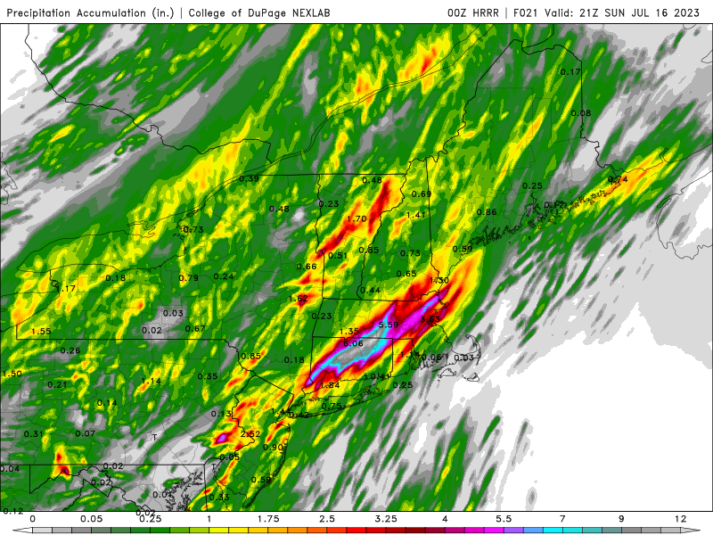
-
July has arrived ... the Meteorologically defined mid summer month
CT Rain replied to Typhoon Tip's topic in New England
Could be a pretty significant flood event tomorrow for someone in SNE based on the 12z runs. Can't rule out a tornado either if some areas destabilize event given the strong low level shear. -
July has arrived ... the Meteorologically defined mid summer month
CT Rain replied to Typhoon Tip's topic in New England
Yup. Lapse rates are steep. -
July has arrived ... the Meteorologically defined mid summer month
CT Rain replied to Typhoon Tip's topic in New England
Albany is probably the best spot ~20z. -
July has arrived ... the Meteorologically defined mid summer month
CT Rain replied to Typhoon Tip's topic in New England
Waiting for Wiz to get excited for tomorrow. Nice looking CAPE and low level shear late tomorrow afternoon through evening for E NY and western New England. Definitely some tornado potential there. -
July has arrived ... the Meteorologically defined mid summer month
CT Rain replied to Typhoon Tip's topic in New England
Ugly -
July has arrived ... the Meteorologically defined mid summer month
CT Rain replied to Typhoon Tip's topic in New England
KHFD 111653Z 26005KT 10SM CLR 30/17 A2983 RMK AO2 SLP102 T03000167 -
July has arrived ... the Meteorologically defined mid summer month
CT Rain replied to Typhoon Tip's topic in New England
Yup. Nice look for the sunrise spinner. -
July has arrived ... the Meteorologically defined mid summer month
CT Rain replied to Typhoon Tip's topic in New England
Can I share this on the news tonight? This is awesome. -
There's been some side lobe contamination there so the occasional couplet has been a bit of an artifact. Basically the stronger winds from aloft in the overhanging core are getting "smeared" down to 0.5 degrees where there is very little reflectivity.
-
Yeah pretty big model bust today. Even the 6z/12z runs today struggled.
-
The 18z GFS has has Bret giving birth to a baby TC that races toward ACK next week. Funny evolution lol
-
Hideous run. With that look we won't be talking about Stein until after Labor Day at least lol
-
Yeah can't rule out a spinup with some decent low level shear.


