yoda
-
Posts
63,545 -
Joined
Content Type
Profiles
Blogs
Forums
American Weather
Media Demo
Store
Gallery
Everything posted by yoda
-
-
So far, and probably still have about 2 more hours to go... but the low temp at DCA is 84
-
From this morning LWX AFD Record temperatures will continue through much of the upcoming Independence Day holiday weekend. An upper ridge remains parked across a vast portion of the southeastern U.S. into the Tennessee/Ohio Valleys and Mid-Atlantic region. Lower tropospheric temperatures remain very anomalous and record breaking in nature. Of note, the 00Z IAD sounding reported an 850-mb temperature of 25.0 C which is not only the 3rd highest of all time, but breaks the daily record by over 4.0 C. Recent 00Z models show a subtle decrease in these 850-mb temperatures. However, based on yesterday`s observations, models have been slightly too cool with this layer of the atmosphere. Thus, see little reason to diverge from another hot forecast with widespread temperatures punching into the 98 to 102 degree range. Even during the writing of this discussion (~3 AM), a number of the warmer spots remain entrenched in the upper 70s to mid 80s. High dew points should also remain a fixture in the forecast with readings holding steady in the low/mid 70s. Although some boundary layer mixing could slightly lower such dew points, the combination of triple digit highs and low 70s dew points will easily crank heat indices to around 110F. Extreme Heat Warnings continue from 10 AM until 9 PM across a bulk of the Mid-Atlantic region. For those in the Blue Ridge, Alleghenies, and across the central Shenandoah Valley, heat indices around 100 to 104 degrees supports Heat Advisories today.
-
86/72 at 4am. HI 92
-
87/77 at 1am... yuck
-
CHO has tied their record high of 100... set back in 1954
-
IAD has tied their record set back in 1966... 99 would break it
-
If thats verified, it will be a new record high for the date, breaking the old record of 101 set in, get this, 1898
-
Day 3 and 4 SLGT up
- 1,011 replies
-
- 2
-

-
- severe
- thunderstorms
- (and 7 more)
-
My apologies if posted already re Saturday URGENT - WEATHER MESSAGE National Weather Service Baltimore MD/Washington DC 132 PM EDT Thu Jul 2 2026 DCZ001-MDZ004>006-008-011-013-014-016>018-503>508-VAZ037>040-050-051- 053>057-501-502-505-506-526-527-030300- /O.UPG.KLWX.XH.A.0002.260704T1400Z-260705T0000Z/ /O.NEW.KLWX.XH.W.0004.260704T1400Z-260705T0000Z/ /O.CON.KLWX.XH.W.0002.000000T0000Z-260703T0000Z/ /O.CON.KLWX.XH.W.0003.260703T1400Z-260704T0000Z/ District of Columbia-Frederick-Carroll-Northern Baltimore-Cecil- Southern Baltimore-Prince Georges-Anne Arundel-Charles-St. Marys- Calvert-Northwest Montgomery-Central and Southeast Montgomery- Northwest Howard-Central and Southeast Howard-Northwest Harford- Southeast Harford-Albemarle-Greene-Madison-Rappahannock-Orange- Culpeper-Fairfax-Arlington/Falls Church/Alexandria-Stafford- Spotsylvania-King George-Northern Fauquier-Southern Fauquier- Western Loudoun-Eastern Loudoun-Northwest Prince William-Central and Southeast Prince William/Manassas/Manassas Park- 132 PM EDT Thu Jul 2 2026 ...EXTREME HEAT WARNING REMAINS IN EFFECT UNTIL 8 PM EDT THIS EVENING... ...EXTREME HEAT WARNING REMAINS IN EFFECT FROM 10 AM TO 8 PM EDT FRIDAY... ...EXTREME HEAT WARNING IN EFFECT FROM 10 AM TO 8 PM EDT SATURDAY... * WHAT...Dangerously hot conditions each afternoon with heat index values between 110 to 113 expected. * WHERE...Portions of DC, central, north central, northeast, northern, and southern Maryland, and central, northern, and northwest Virginia. * WHEN...For the first Extreme Heat Warning, until 8 PM EDT this evening. For the second Extreme Heat Warning, from 10 AM to 8 PM EDT Friday. For the third Extreme Heat Warning, from 10 AM to 8 PM EDT Saturday. * IMPACTS...Heat related illnesses increase significantly during extreme heat and high humidity events.
-
 Okay, that makes more sense. Thanks
 -
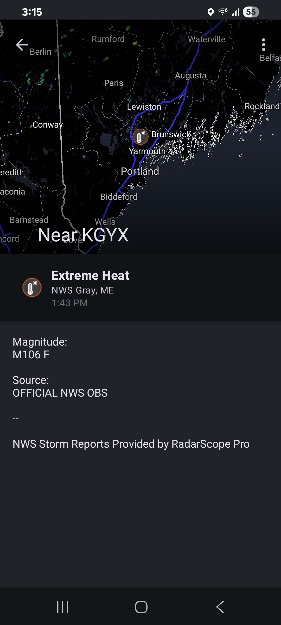
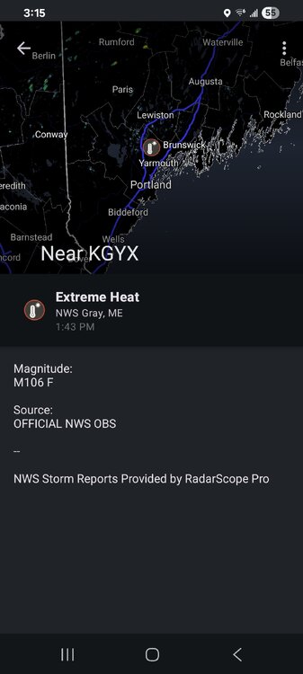
I see on Radarscope that Gray ME official NWS obs of 106? Is that heat index?
-
DCA has been sitting at 99 for awhile
-
Back for one more year of disappointment I see https://russianmachineneverbreaks.com/2026/07/02/alex-ovechkin-return-washington-capitals-contract-one-year-retirement/ https://www.prohockeyrumors.com/2026/07/capitals-sign-alex-ovechkin-to-one-year-contract.html#ref=home
-
I know what @MN Transplant said about the 5 min temps... but 99/74/110 at 1240pm at DCA is atrocious
-
How did you and @wxmeddler get one going for MD?
-
DCA reached 90 degrees at 855am... I'm thinking 103 today for a high temperature https://www.weather.gov/wrh/timeseries?site=kdca
-
URGENT - WEATHER MESSAGE National Weather Service Baltimore MD/Washington DC 836 AM EDT Thu Jul 2 2026 DCZ001-MDZ004>006-008-011-013-014-016>018-503>508-VAZ037>040-050-051- 053>057-501-502-505-506-526-527-022100- /O.NEW.KLWX.XH.A.0002.260704T1400Z-260705T0000Z/ /O.CON.KLWX.XH.W.0002.260702T1400Z-260703T0000Z/ /O.CON.KLWX.XH.W.0003.260703T1400Z-260704T0000Z/ District of Columbia-Frederick-Carroll-Northern Baltimore-Cecil- Southern Baltimore-Prince Georges-Anne Arundel-Charles-St. Marys- Calvert-Northwest Montgomery-Central and Southeast Montgomery- Northwest Howard-Central and Southeast Howard-Northwest Harford- Southeast Harford-Albemarle-Greene-Madison-Rappahannock-Orange- Culpeper-Fairfax-Arlington/Falls Church/Alexandria-Stafford- Spotsylvania-King George-Northern Fauquier-Southern Fauquier- Western Loudoun-Eastern Loudoun-Northwest Prince William-Central and Southeast Prince William/Manassas/Manassas Park- 836 AM EDT Thu Jul 2 2026 ...EXTREME HEAT WARNING REMAINS IN EFFECT UNTIL 8 PM EDT THIS EVENING... ...EXTREME HEAT WARNING REMAINS IN EFFECT FROM 10 AM TO 8 PM EDT FRIDAY... ...EXTREME HEAT WATCH IN EFFECT FROM SATURDAY MORNING THROUGH SATURDAY EVENING... * WHAT...For the first Extreme Heat Warning, dangerously hot conditions with heat index values up to 111 expected. For the second Extreme Heat Warning, dangerously hot conditions with heat index values up to 112 expected. For the Extreme Heat Watch, dangerously hot conditions with heat index values up to 110 possible. * WHERE...Portions of DC, central, north central, northeast, northern, and southern Maryland, and central, northern, and northwest Virginia. * WHEN...For the first Extreme Heat Warning, until 8 PM EDT this evening. For the second Extreme Heat Warning, from 10 AM to 8 PM EDT Friday. For the Extreme Heat Watch, from Saturday morning through Saturday evening. * IMPACTS...Heat related illnesses increase significantly during extreme heat and high humidity events.
-
Looks like 80 will be the low temp at DCA https://www.weather.gov/wrh/timeseries?site=kdca
-
81/76 at 5am at DCA... yuck
-
X Zone Forecast Product National Weather Service Baltimore MD/Washington DC 226 PM EDT Wed Jul 1 2026 DCZ001-012200- District of Columbia- Including the cities of Adams Morgan and Washington 226 PM EDT Wed Jul 1 2026 ...HEAT ADVISORY REMAINS IN EFFECT UNTIL 8 PM EDT THIS EVENING... ...EXTREME HEAT WARNING IN EFFECT FROM 10 AM TO 8 PM EDT THURSDAY... ...EXTREME HEAT WARNING IN EFFECT FROM 10 AM TO 8 PM EDT FRIDAY... .THIS AFTERNOON...Sunny, hot with highs in the upper 90s. Southwest winds 5 to 10 mph with gusts up to 20 mph. Heat index values up to 109. .TONIGHT...Mostly clear. Isolated showers and thunderstorms in the evening. Lows in the upper 70s. Southwest winds 5 to 10 mph. Chance of rain 20 percent. .THURSDAY...Sunny, hot with highs around 103. West winds around 5 mph. Heat index values up to 111. .THURSDAY NIGHT...Clear. Lows around 80. Southwest winds around 5 mph in the evening, becoming light and variable. .FRIDAY...Sunny, hot with highs around 104. Northwest winds around 5 mph. Heat index values up to 113. .FRIDAY NIGHT...Partly cloudy. Lows around 80. .INDEPENDENCE DAY...Mostly sunny with a chance of showers and thunderstorms. Hot with highs around 100. Chance of rain 50 percent. Heat index values up to 110. .SATURDAY NIGHT...Mostly cloudy with a chance of showers and thunderstorms. Lows in the upper 70s. Chance of rain 50 percent. .SUNDAY...Showers likely with a chance of thunderstorms. Hot with highs in the upper 90s. Chance of rain 60 percent. Heat index values up to 110.
-
GENT - WEATHER MESSAGE National Weather Service Baltimore MD/Washington DC 132 PM EDT Wed Jul 1 2026 DCZ001-MDZ004>006-008-011-013-014-016>018-503>508-VAZ037>040-050-051- 053>057-501-502-505-506-526-527-020300- /O.UPG.KLWX.XH.A.0001.260702T1500Z-260704T0000Z/ /O.NEW.KLWX.XH.W.0003.260703T1400Z-260704T0000Z/ /O.NEW.KLWX.XH.W.0002.260702T1400Z-260703T0000Z/ /O.CON.KLWX.HT.Y.0004.000000T0000Z-260702T0000Z/ District of Columbia-Frederick-Carroll-Northern Baltimore-Cecil- Southern Baltimore-Prince Georges-Anne Arundel-Charles-St. Marys- Calvert-Northwest Montgomery-Central and Southeast Montgomery- Northwest Howard-Central and Southeast Howard-Northwest Harford- Southeast Harford-Albemarle-Greene-Madison-Rappahannock-Orange- Culpeper-Fairfax-Arlington/Falls Church/Alexandria-Stafford- Spotsylvania-King George-Northern Fauquier-Southern Fauquier- Western Loudoun-Eastern Loudoun-Northwest Prince William-Central and Southeast Prince William/Manassas/Manassas Park- 132 PM EDT Wed Jul 1 2026 ...HEAT ADVISORY REMAINS IN EFFECT UNTIL 8 PM EDT THIS EVENING... ...EXTREME HEAT WARNING IN EFFECT FROM 10 AM TO 8 PM EDT THURSDAY... ...EXTREME HEAT WARNING IN EFFECT FROM 10 AM TO 8 PM EDT FRIDAY... * WHAT...For the Heat Advisory, heat index values up to 107. For the first Extreme Heat Warning, dangerously hot conditions with heat index values up to 111 expected. For the second Extreme Heat Warning, dangerously hot conditions with heat index values up to 112 expected. * WHERE...Portions of DC, central, north central, northeast, northern, and southern Maryland, and central, northern, and northwest Virginia. * WHEN...For the Heat Advisory, until 8 PM EDT this evening. For the first Extreme Heat Warning, from 10 AM to 8 PM EDT Thursday. For the second Extreme Heat Warning, from 10 AM to 8 PM EDT Friday. * IMPACTS...Heat related illnesses increase significantly during extreme heat and high humidity events. Hot temperatures and high humidity may cause heat illnesses.
-
Looks like 82/70 at 9am for DC
-
For tomorrow URGENT - WEATHER MESSAGE National Weather Service Baltimore MD/Washington DC 1243 PM EDT Mon Jun 29 2026 MDZ502-WVZ050-055-502-504-506-300100- /O.NEW.KLWX.HT.Y.0003.260630T1500Z-260701T0000Z/ Central and Eastern Allegany-Hampshire-Hardy-Eastern Grant- Eastern Mineral-Eastern Pendleton- 1243 PM EDT Mon Jun 29 2026 ...HEAT ADVISORY IN EFFECT FROM 11 AM TO 8 PM EDT TUESDAY... * WHAT...Heat index values up to 102 expected. * WHERE...In Maryland, Central and Eastern Allegany County. In West Virginia, Eastern Grant, Eastern Mineral, Eastern Pendleton, Hampshire, and Hardy Counties. * WHEN...From 11 AM to 8 PM EDT Tuesday. * IMPACTS...Hot temperatures and high humidity may cause heat illnesses. PRECAUTIONARY/PREPAREDNESS ACTIONS... Drink plenty of fluids, stay in an air-conditioned room, stay out of the sun, and check up on relatives and neighbors. Take extra precautions when outside. Wear lightweight and loose fitting clothing. Try to limit strenuous activities to early morning or evening. Take action when you see symptoms of heat exhaustion and heat stroke. To reduce risk during outdoor work, the Occupational Safety and Health Administration recommends scheduling frequent rest breaks in shaded or air conditioned environments. Anyone overcome by heat should be moved to a cool and shaded location. Heat stroke is an emergency! In cases of heat stroke, call 9 1 1.
-
So if we hit it twice, does this mean you will watch it 4 times?