yoda
-
Posts
63,587 -
Joined
Content Type
Profiles
Blogs
Forums
American Weather
Media Demo
Store
Gallery
Everything posted by yoda
-
Islanders and Penguins and Bruins all winning so far tonight... so Top 4 will all remain same and no one will gain any ground
-
78 at DCA, tying the record
-
Could be some record high lows tonight too... from this afternoon's LWX AFD:
-
No caught it indeed
-
Are you Jake? From State Farm?
-
This is the meme I think of when Ji complains about losing digital snow
-
I demand a radio show hosted by Wes for this threat
-
All green though... no blue lol
-
Both 12z CMC and Para GFS say no btw... here is old GFS
-
Def was waiting for you to complain about teh radar depiction at 126
-
Wait... so you don't stay up till 2am for the Euro in March if there is a chance of snow? What kind of weather weenie are you?
-
7 games it is
-
Indeed... sounds like 5+ game ban incoming https://www.prohockeyrumors.com/2021/03/tom-wilson-to-have-in-person-hearing-with-nhl-player-safety.html?fv-home=true&post-id=134529
-
It has no real warm weather... CMC was boring... and weather for the next 10 days will be boring.... so what else to do?
-
I see Wilson is back to his goon ways...
-
00z GFS laughs at the 18z GFS and says 18z must have had too much to drink. 00z GFS has 60s Wed/Thur and 70 on Friday... but then cool air returns next weekend with highs in the 40s Sat and around 50 on Sun Week of the 15th had warm Monday... but then Tues-Fri must have a backdoor front around cause highs are mainly in the 40s and 50s.... and stays there in the super extended
-
Please tell the 00z EURO to take the h5 map at Day 10 and return to sender
-
Both 00z GFS and 00z CMC get nice and warm next week Wed-Fri... then both show a nasty backdoor CF around on Saturday
-
-
-
-
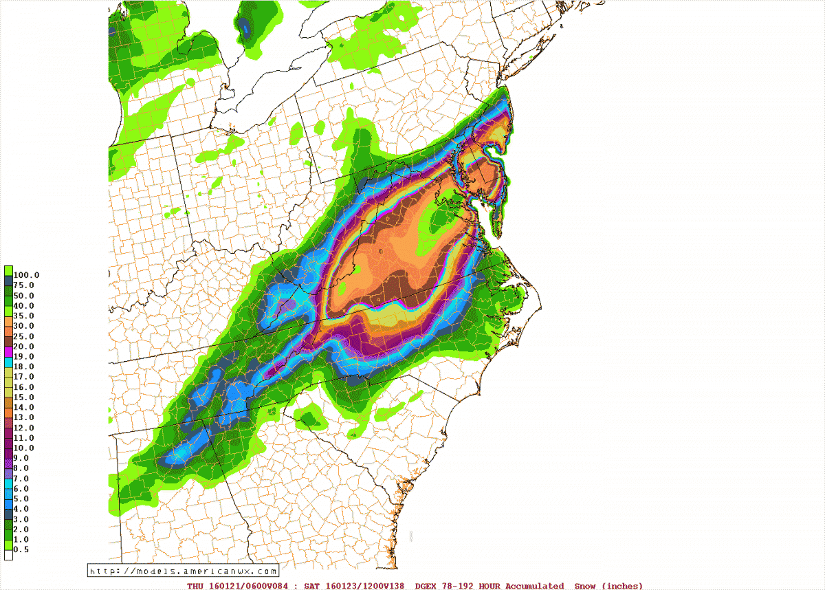
Ahhh.. the ole DGEX... for the Jan 2016 storm
-
Yeah oops... completely forgot about this. I will check my old computer and see if they is anything on it. I do have a bunch of saved model images from the month of Jan 2016 in my attachments folder... almost three pages worth lol
-
Big earthquake in the Pacific... M8.0... Tsunami Watch issued for Hawaii. Tsunami Warnings for parts of NZ