yoda
-
Posts
63,536 -
Joined
Content Type
Profiles
Blogs
Forums
American Weather
Media Demo
Store
Gallery
Everything posted by yoda
-
Both 00z GFS and 00z CMC get nice and warm next week Wed-Fri... then both show a nasty backdoor CF around on Saturday
-
-
-
-
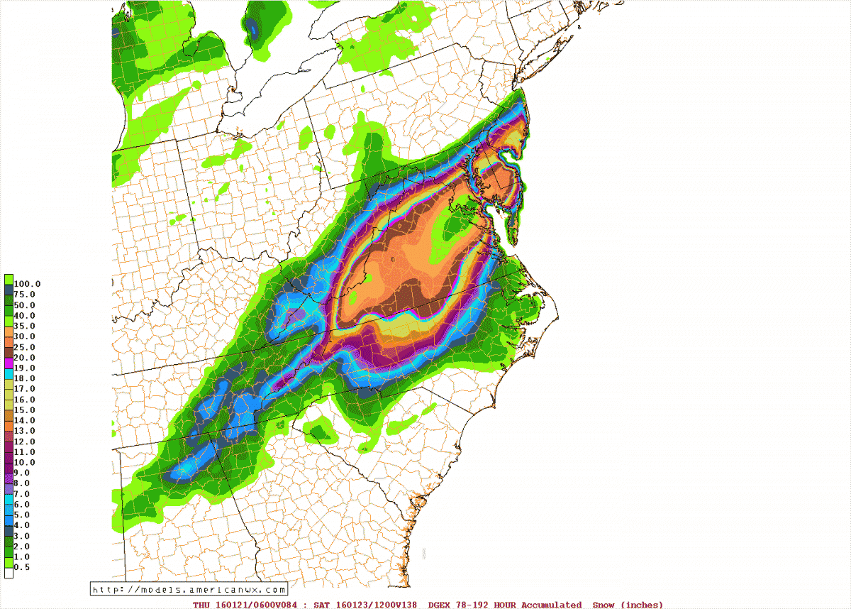
Ahhh.. the ole DGEX... for the Jan 2016 storm
-
Yeah oops... completely forgot about this. I will check my old computer and see if they is anything on it. I do have a bunch of saved model images from the month of Jan 2016 in my attachments folder... almost three pages worth lol
-
Big earthquake in the Pacific... M8.0... Tsunami Watch issued for Hawaii. Tsunami Warnings for parts of NZ
-
Okay then Washington Football Team replaces cheerleaders with coed dance squad https://www.espn.com/nfl/story/_/id/30996155/washington-football-team-replaces-cheerleaders-dance-squad
-
Technically Kyle Allen is a ERFA... he doesn't have a team right now. Washington is the only team who can negotiate with him... so he will be signed, but for how much and how long
-
Yes... but who is backing him up? What if he goes down with an injury? Right now, we have no one
-
I understand that... but who do we have at QB? Heincke? Why not have Alex Smith as a back up to teach the new QB?
-
BULLETIN - IMMEDIATE BROADCAST REQUESTED Special Marine Warning National Weather Service Baltimore MD/Washington DC 1038 AM EST Mon Mar 1 2021 The National Weather Service in Sterling Virginia has issued a * Special Marine Warning for... Chesapeake Bay from North Beach to Drum Point MD... Chesapeake Bay from Pooles Island to Sandy Point MD... Chesapeake Bay from Sandy Point to North Beach MD... Chesapeake Bay north of Pooles Island MD... Chester River to Queenstown MD... Choptank River to Cambridge MD and the Little Choptank River... Eastern Bay... Patapsco River including Baltimore Harbor... * Until 1215 PM EST. * At 1037 AM EST, gust fronts were located along a line extending from 12 nm northwest of Middle River to 11 nm north of Key Bridge, moving east at 35 knots. HAZARD...Wind gusts 34 knots or greater. SOURCE...Radar indicated. IMPACT...Boaters in small craft could be thrown overboard by suddenly higher winds and waves capsizing their vessel. * Locations impacted include... North Point State Park, Magothy River, Chester River, Eastern Bay, Pooles Island, Herring Bay, Gunpowder River, Sandy Point State Park, Bloody Point Light, Thomas Point Light, Poplar Island, Parsons Island, Fort Smallwood State Park, Pinehurst, Turkey Point, Aberdeen Proving Ground, Knapps Narrows Bridge, Hart Miller Island, Tilghman Island and Gibson Island. PRECAUTIONARY/PREPAREDNESS ACTIONS... Seek safe shelter, mariners can expect gusty winds and increasing waves.
-
BULLETIN - IMMEDIATE BROADCAST REQUESTED Special Marine Warning National Weather Service Baltimore MD/Washington DC 1036 AM EST Mon Mar 1 2021 The National Weather Service in Sterling Virginia has issued a * Special Marine Warning for... Tidal Potomac from Indian Head to Cobb Island MD... Tidal Potomac from Key Bridge to Indian Head MD... * Until 1130 AM EST. * At 1036 AM EST, gust fronts were located along a line extending from 20 nm west of Fort Smallwood State Park to 11 nm west of Key Bridge to 30 nm northwest of Quantico, moving southeast at 30 knots. HAZARD...Wind gusts 34 knots or greater. SOURCE...Radar indicated. IMPACT...Boaters in small craft could be thrown overboard by suddenly higher winds and waves capsizing their vessel. * Locations impacted include... Potomac Creek, Maryland Point, Nanjemoy Creek, Port Tobacco River, Leesylvania State Park, National Harbor, Quantico, Fort Washington, Tidal Basin, Reagan National Airport, Swan Point, Gunston Hall, Mathias Point, U.S. 301 Nice Memorial Bridge, Mason Neck State Park, Woodrow Wilson Bridge, Indian Head, Occoquan Bay, Fort Hunt and Popes Creek. PRECAUTIONARY/PREPAREDNESS ACTIONS... Seek safe shelter, mariners can expect gusty winds and increasing waves.
-
Welp, Alex Smith and WFT are going to part ways... that sucks. Hope Alex Smith catches on to another team https://www.profootballrumors.com/2021/03/washington-to-cut-alex-smith
-
I have DOGE... holding around $3K in it right now. I know it's a long term thing and yeah, it's up and down like crazy but still fine. And yes, this is money I can play with lol
-
@George BM will not be pleased lol
-
1.5 GB of playoffs
-
All major 00z models basically have no snow for anyone through the end of their runs tonight
-
Anyone following this supposed resurgent Wizards team?
-
It got deleted
-
I heard that the two main words used back then were meh and next
-
But are they getting more snow in that other country than us?
-
Well done good sir https://www.espn.com/nfl/story/_/id/30954145/ravens-coach-john-harbaugh-pays-bill-entire-seafood-restaurant-baltimore-charity-event
-
Mmm... so nice to beat the Caps AGAIN... 3-2 OT victory
-
You weren't here for the derechos?