ncskywarn
-
Posts
540 -
Joined
-
Last visited
Content Type
Profiles
Blogs
Forums
American Weather
Media Demo
Store
Gallery
Everything posted by ncskywarn
-
This would be ugly.
-
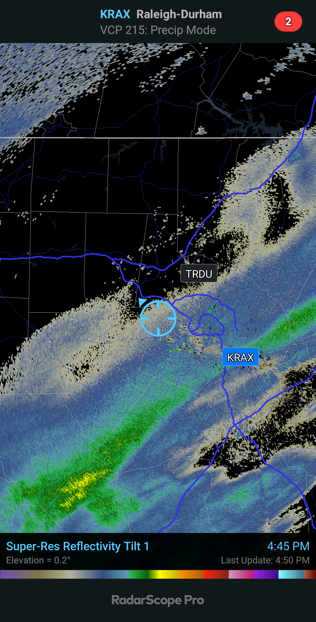
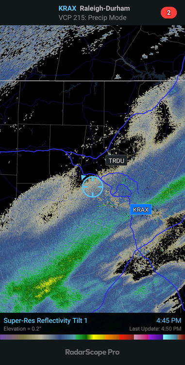
Started snowing in Western Cary, Carpenter area about 10-15 minutes ago. Small flakes but it is snowing.
-
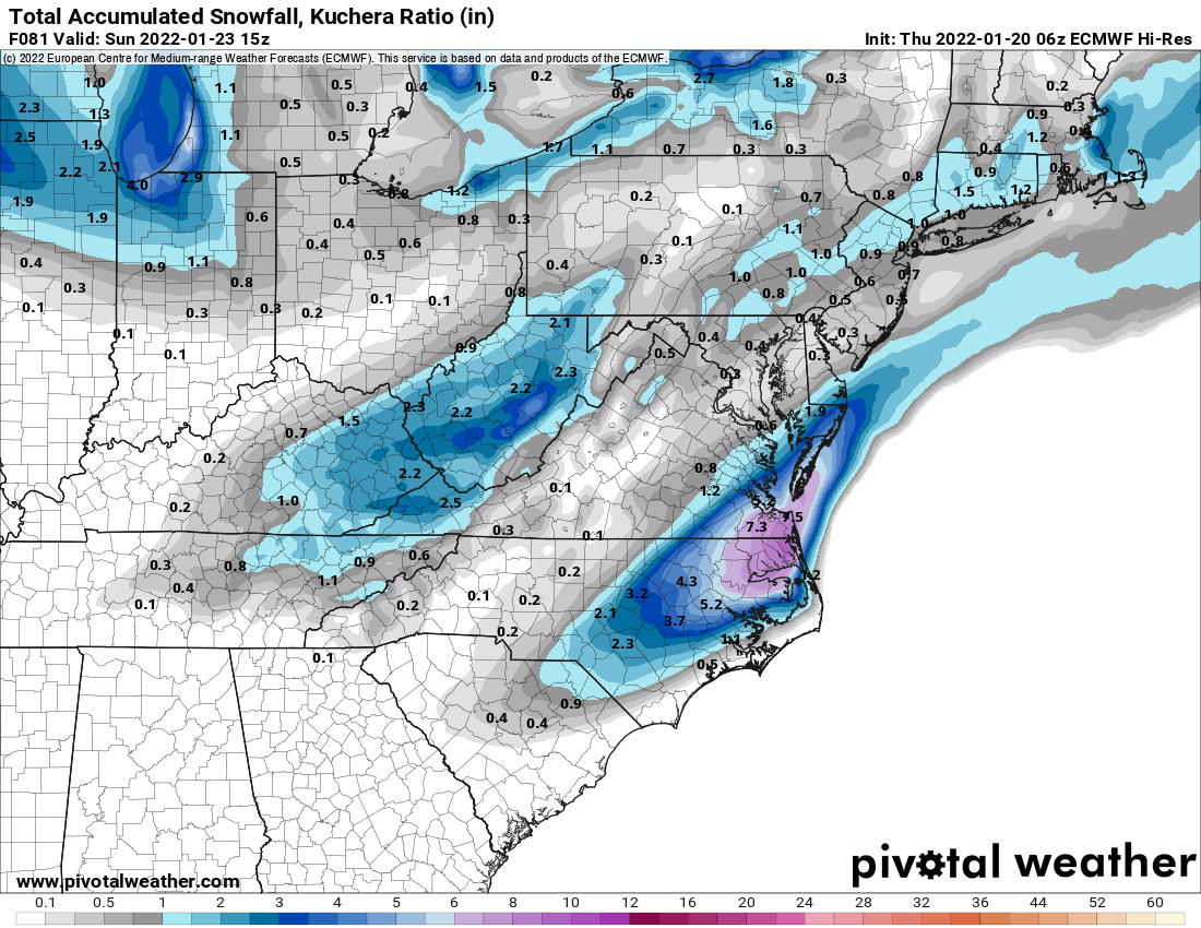
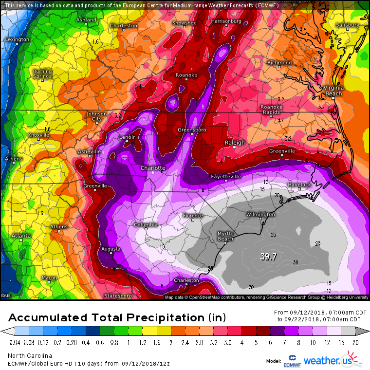
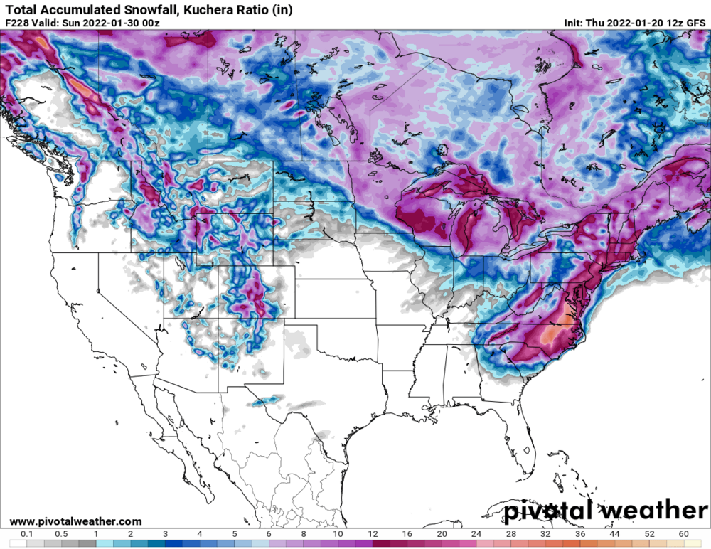
To make it even more laughable Wake County gets more snow on that map then anywhere else in the United States or Canada.
-
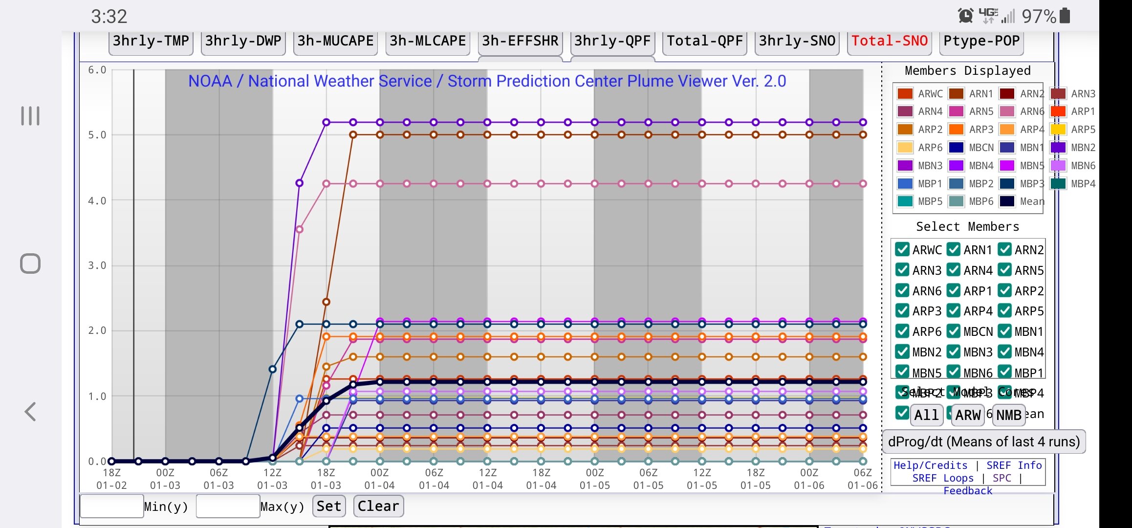
January 20-22 “bring the mojo” winter storm threat
ncskywarn replied to lilj4425's topic in Southeastern States
-
January 20-22 “bring the mojo” winter storm threat
ncskywarn replied to lilj4425's topic in Southeastern States
Someone on Southern Weather said that the HRRR uses the same algorithm that the RAP uses. So that really is not unexpected or surprising. -
January 20-22 “bring the mojo” winter storm threat
ncskywarn replied to lilj4425's topic in Southeastern States
Even is the models trend back with more QPF do you really think that Western Wake County will only be in the 1-2 inch range? -
January 20-22 “bring the mojo” winter storm threat
ncskywarn replied to lilj4425's topic in Southeastern States
WAR flexed just enough to slow down the NS and allow the SS to catch up just a little. -
January 20-22 “bring the mojo” winter storm threat
ncskywarn replied to lilj4425's topic in Southeastern States
Not necessarily because that would cause WAA mixing issues and a lot of ice. That many of us don't want to see. -
RDU SERF
-
Just changed over to all snow now.
-
Still rain/snow mix Cary Park area of West Cary.
-
https://www.severestudios.com/livechase/
-
-
06Z GFS significantly further South compaired to 00Z at hour 96. Edit: Ends up about the same place though at hour 120. By hour 150 the low ends up further North over the NC sounds just West of Hatteras. compaired to off the coast East of the NC/SC border a lot more rain then snow for a lot of people.
-
SUMMARY OF 1100 PM EDT...0300 UTC...INFORMATION ----------------------------------------------- LOCATION...34.0N 76.8W ABOUT 50 MI...80 KM S OF MOREHEAD CITY NORTH CAROLINA ABOUT 60 MI...95 KM ESE OF WILMINGTON NORTH CAROLINA MAXIMUM SUSTAINED WINDS...90 MPH...150 KM/H PRESENT MOVEMENT...NW OR 305 DEGREES AT 6 MPH...9 KM/H MINIMUM CENTRAL PRESSURE...956 MB...28.23 INCHES
-
SUMMARY OF 1000 PM EDT...0200 UTC...INFORMATION ---------------------------------------------- LOCATION...34.0N 76.7W ABOUT 50 MI...80 KM S OF MOREHEAD CITY NORTH CAROLINA ABOUT 70 MI...115 KM ESE OF WILMINGTON NORTH CAROLINA MAXIMUM SUSTAINED WINDS...100 MPH...160 KM/H PRESENT MOVEMENT...NW OR 305 DEGREES AT 5 MPH...8 KM/H MINIMUM CENTRAL PRESSURE...956 MB...28.23 INCHES
-
According to the Mayor that was a erroneous report anyway. That's why I deleted it.
-
GFS at 36 almost identical to 18Z. At 66 just a little East of 18Z.
-
Looks like Northern model trends continue next up GFS
-
Sorry I deleted my reply it started workingf again.
-
ICON is West at 21. Edit: makes landfall near North Topsail at 33 and is moving West inland at 48.
-
ICON is West at 21
-
NAM is NW made landfall near Wilmington at hour 33 moving W at hour 36 & 39 stalled on the NC & SC border at 42 & 45. Edit: still stalled same place hour 51.
-
Todays modle runs have ttrended ever so slightly north. Charlotte
-
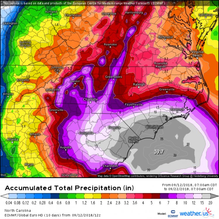
Here is the 240 hour 12Z Euro map.