ncskywarn
-
Posts
540 -
Joined
-
Last visited
Content Type
Profiles
Blogs
Forums
American Weather
Media Demo
Store
Gallery
Everything posted by ncskywarn
-
Another good imaging website. https://weather.cod.edu/satrad/exper/?parms=meso-meso1-14-48-1-100-1&checked=map&colorbar=undefined
-
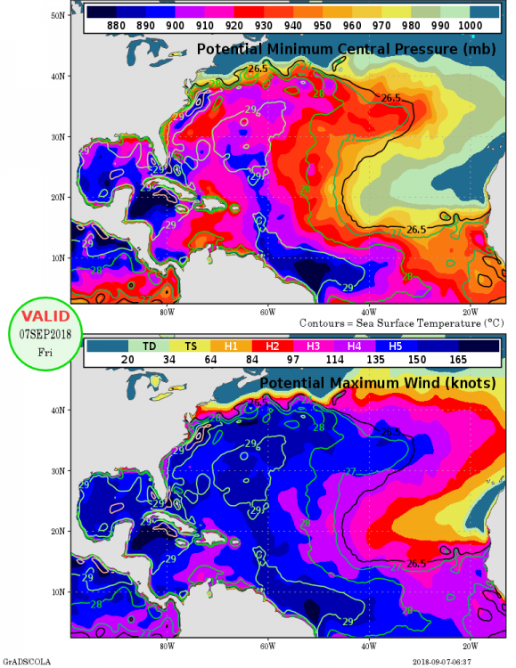
CAT 4!!!!! 368 WTNT61 KNHC 101556 TCUAT1 Hurricane Florence Tropical Cyclone Update NWS National Hurricane Center Miami FL AL062018 1200 PM AST Mon Sep 10 2018 ...FLORENCE BECOMES A CATEGORY FOUR HURRICANE... Data from a NOAA Hurricane Hunter aircraft indicate that Florence has continued to rapidly stregthen and has maximum sustained winds near 130 mph (195 km/h). The latest minimum central pressure based on data from the aircraft is 946 mb (27.93 inches). SUMMARY OF 1200 PM AST...1600 UTC...INFORMATION --------------------------------------------------- LOCATION...25.0N 60.2W ABOUT 575 MI...925 KM SSE OF BERMUDA ABOUT 1230 MI...1985 KM ESE OF CAPE FEAR NORTH CAROLINA MAXIMUM SUSTAINED WINDS...130 MPH...195 KM/H PRESENT MOVEMENT...W OR 280 DEGREES AT 13 MPH...20 KM/H MINIMUM CENTRAL PRESSURE...946 MB...27.93 INCHES $$ Forecaster Blake
-
ICON at hour 63 is just a tad SW of 06Z ridge appears to be a little stronger.
-
Will the data collected this afternoon be incorporated into tonight's 00Z model run?
-
WOW JUST WOW!!!!!
-
Doesn't look like it's East of the 06Z run. Looks like it's not going to make landfall.
-
Still a touch Southwest at 72
-
At 48 looks a touch South 06Z
-
Out 24 hours maybe just a little bit further West.
-
GFS just initialized.
-
Just saw couple of FEMA (Federal Emergency Management Agency) trucks in Raleigh.
-
This would be a monster.
.png.eb22953a517d864f550f93f6c3f5f7c7.png)
-
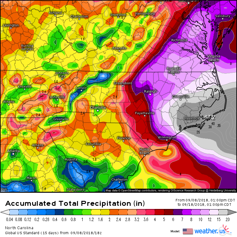
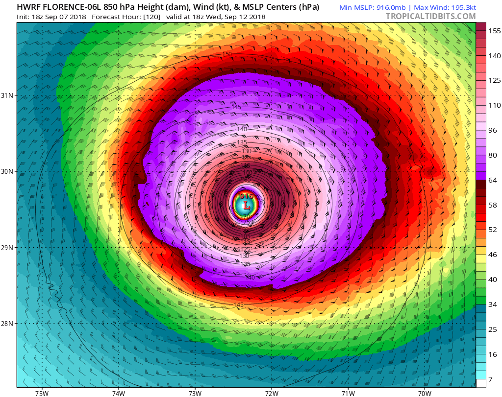
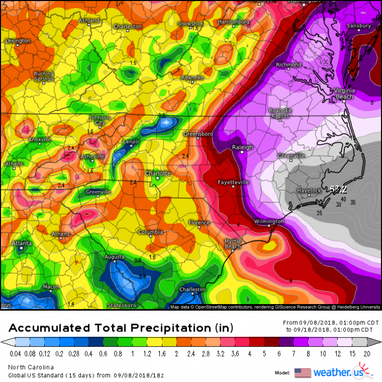
WOW HWRF 195 Kt=225 MPH at the 850 level at hour 120. Looks definitely plausible when you look at the bottom 2 images.

-
Maybe a little bit early but probably prudent. At least it's giving him 5 or 6 days to get resources set up and in place. As opposed to waiting and having to rush and only having 2 or 3 days to get the same resources set up. Especially if this ends up being worse case scenario and ends up effecting the entire state.
-
From the NWS Raleigh AFD kind of ominous. While the risk of impacts associated with Florence along the East Coast has increased, there is too much model spread/uncertainty to speculate what kind of impacts we can expect here in central NC. Given current model projections, impacts, if any, will be possible during the mid to late week period. Residents of central NC are strongly encouraged to closely monitor the latest forecasts and to ensure everyone has emergency kits and hurricane plan in place. It is never too early to prepare!
-
Actually looks like 18Z landfall was a little North of 12Z. Biggest difference that I see is at landfall it's moving more NNW as opposed to NW. Compaired to 12Z. Never makes it as far inland.
-
Not surprisingly so it begins.
-
12Z Euro is running out to 24 hours
-
In other words same old same old.
-
NAM is running lets see if it holds.