

Tatamy
-
Posts
2,581 -
Joined
-
Last visited
Content Type
Profiles
Blogs
Forums
American Weather
Media Demo
Store
Gallery
Everything posted by Tatamy
-
Two things to look for in today’s model runs will be better sampling of the shortwaves involved (looks to be already happening) and the dataset obtained from the scheduled recon out in the PAC. That data is expected to make it into the 0z runs tonight according to the NHC website.
-
Models are actually honing in on a solution. It’s good that we are starting to see a consensus of sorts shaping up. There is still time for all this to change. Based upon what I have been seeing on 500mb charts I really am not seeing a pathway for the higher amounts to come further inland. It kind of reminds me of the huge I287 gradient that set up with Boxing Day in 2010.
-
With this morning’s runs this event is shaping up to be significant south and east of the Driscoll Bridge on the Jersey shore and S&E of I95 elsewhere. It’s the reverse of what we see many times however this go around it appears to be the coastal areas turn for snow. Nearby inland suburbs get much less with a big time gradient setting up for snow amounts very close to the city. Places well to the north and west look to smoke cirrus. I would consider the Euro to be an outlier at this time with higher amounts to the north and west as compared to the other models.
-
?
-
06z GFS comes west. 6-12” for the Jersey shore, SI, Brooklyn, Queens, and LI. Higher amounts further east.
-
06z Icon is a nice hit for the Jersey shore, the city, and LI. 4-7” in those places with less further away from the coast.
-
06z NAM has several inches for the Jersey shore and central and eastern LI..
-
SLP at least 50 miles further east as compared to 18z.
-
They are sending Recon out into the PAC tomorrow: NOUS42 KNHC 251930 REPRPD WEATHER RECONNAISSANCE FLIGHTS CARCAH, NATIONAL HURRICANE CENTER, MIAMI, FL. 0230 PM EST TUE 25 JANUARY 2022 SUBJECT: WINTER SEASON PLAN OF THE DAY (WSPOD) VALID 26/1100Z TO 27/1100Z JANUARY 2022 WSPOD NUMBER.....21-056 AMENDMENT I. ATLANTIC REQUIREMENTS 1. NEGATIVE RECONNAISSANCE REQUIREMENTS. 2. OUTLOOK FOR SUCCEEDING DAY: POSSIBLE MISSION ALONG TRACK 65 FOR 28/0000Z. II. PACIFIC REQUIREMENTS 1. FLIGHT ONE - NOAA 49 A. 27/0000Z B. NOAA9 01WSC IOP04 C. 26/1900Z (CHANGED) D. 30 DROPS APPROXIMATELY 60 NM APART WITHIN AREA BOUNDED BY 20.0N 180.0W, 20.0N 155.0W, 40.0N 155.0W, AND 40.0N 180.0W. E. 41,000 TO 45,000 FT/ 26/2030Z-27/0230Z 2. OUTLOOK FOR SUCCEEDING DAY: A USAF RESERVE WC-130J AIRCRAFT AND THE NOAA G-IV AIRCRAFT MAY FLY TWO CONCURRENT ATMOSPHERIC RIVERS MISSIONS OVER THE CENTRAL AND EASTERN PACIFIC FOR THE 28/0000Z SYNOPTIC TIME. 3. ADDITIONAL DAY OUTLOOK: A USAF RESERVE WC-130J AIRCRAFT MAY FLY ANOTHER ATMOSPHERIC RIVERS MISSION OVER THE EASTERN AND CENTRAL PACIFIC FOR THE 29/0000Z SYNOPTIC TIME.
-
Still east
-
06z Euro has run up to 90 hours. Looks very similar to the 0z run at this point. SLP to the south of Cape Hatteras might be a smidge to the east.
-
06z GFS still brings several inches to central and southern NJ and out on LI.
-
06z GFS looks to be holding serve at 500mb at this stage of its run as compared to 0z
-
06z RGEM looks really nice at 500mb at the end of its run. It’s not holding back in the SW.
-
06z ICON brings a few inches to the Jersey shore with higher amounts out on LI.
-
06z NAM at the end of its range is flatter and holds back energy in the SW.
-
I would have received 3” at 12z and I would still get that on this run. You can’t make this up…
-
CMC at 132 hrs
-
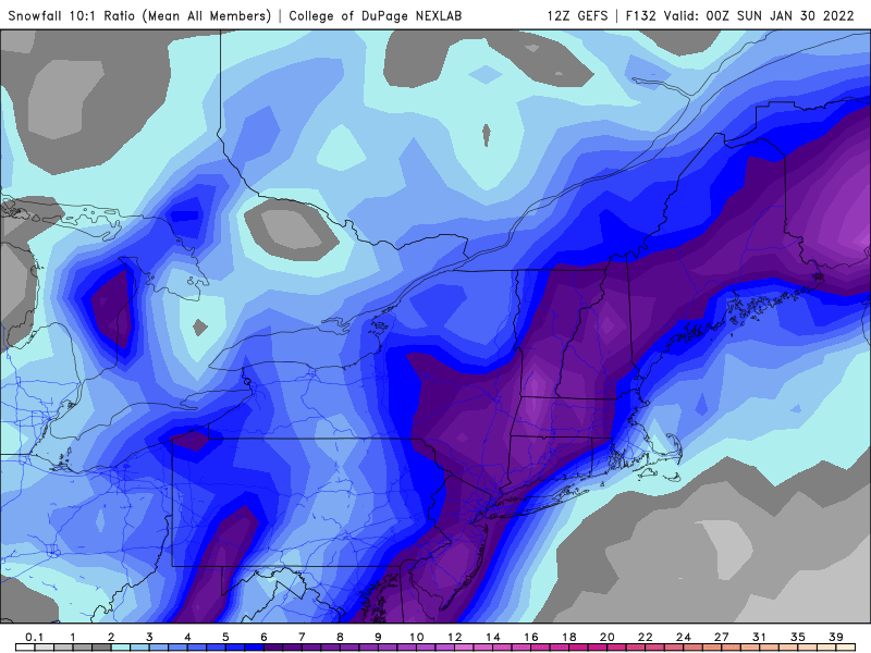
12z GEFS
-
 2/2/76 reached down to 970 mb at my location at the time on the north shore of LI.
 -
Down to a mile in light snow. 30*
-
Very light snow 31 degrees; visibility 5 miles.
-
Light snow is moving east through eastern sections of PA at this time. I am seeing visibilities in the range of a mile or so to the west of Allentown at this time.
-
On the 12z GEFS, out of 20 members, one hits the whole area, another is an inland runner, another clips the east end of LI, and the remainder bring minimal or nothing.
-
Look at 500mb - no bueno - trough is flatter.


