

Tatamy
-
Posts
2,585 -
Joined
-
Last visited
Content Type
Profiles
Blogs
Forums
American Weather
Media Demo
Store
Gallery
Everything posted by Tatamy
-
 12z Euro at 120 hrs. If this verifies you will have tropical storm force winds along the Jersey shore, NY harbor, and along the south shore of LI.
 -
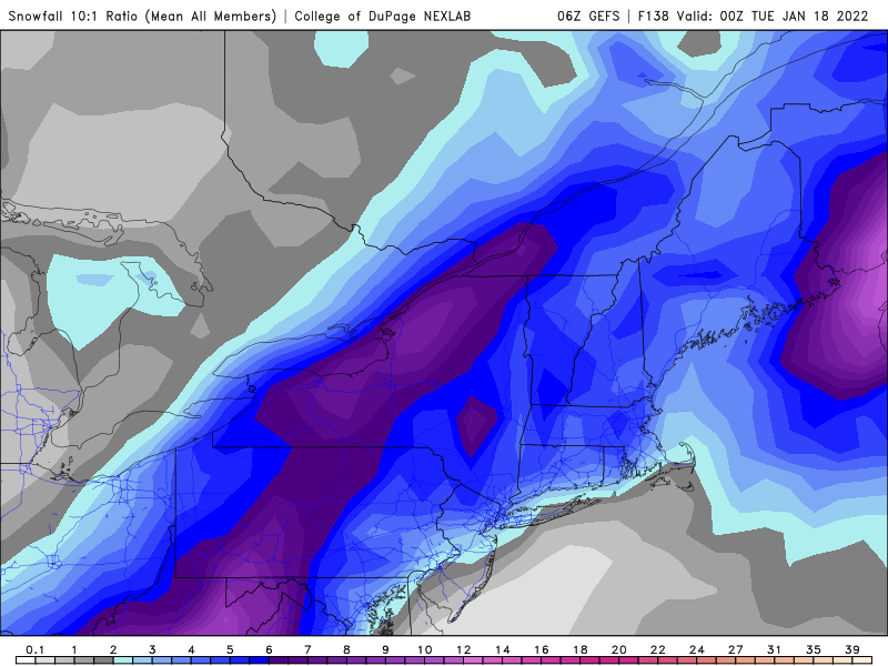
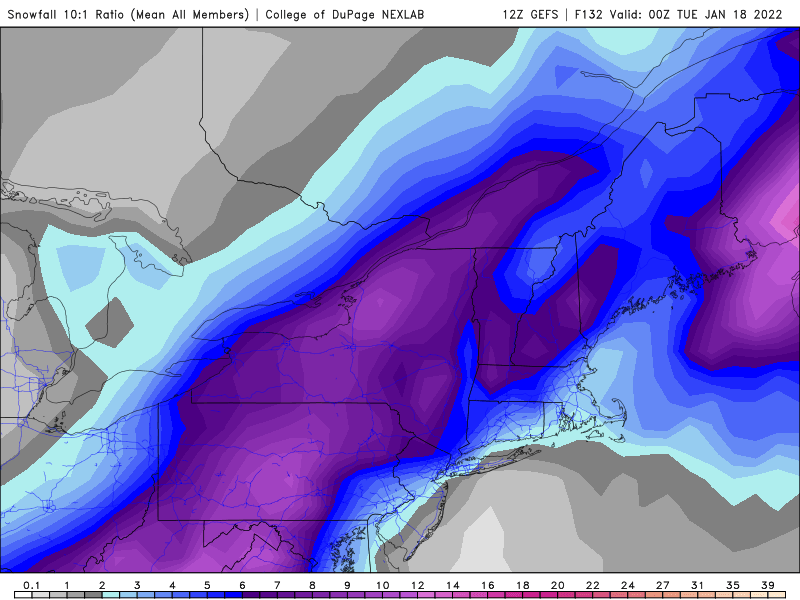
Here is the ensemble mean snowfall (GEFS) estimates for this system for 6z and 12z. 6z 12z
-
Go to the state that you are interested in and lookup the DOT website for it. It will provide a link to highway webcams on the major roads.
-
I my original post I was referring to areas well inland away from the coast. As modeled there is a fair amount of sleet and freezing rain associated with this storm in those places. Strongly agree that the strong easterly or SE flow will kill chances for freezing/frozen precip near the coast.
-
Ensemble mean now has the axis of heaviest snows up through the central appalachians. OP is really leading the way on this one.
-
This is morphing from a coastal to an inland runner to an apps runner - and it’s not done yet. The part that remains somewhat interesting is the CAD ahead of the storm east of the spine of the appalachians. Whether this continues and to what degree is an open question.
-
If you look at the boundary level on the 12z Euro at 10m you will have a stiff easterly flow across LI and along the Jersey shore. Ocean temps are in the upper 40s which is 5-8 degrees above normal for this time of the year. That will not hold the cold air in those coastal areas. The ageostrophic flow which will be present just inland with the vector you described will hold that cold air at least for a time there. I do not see massive front snow to the coast with this run. In any case it’s all hypothetical at this point anyways.
-
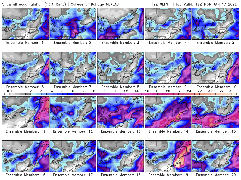
On the 12z GEFS only 3 of 20 members were solid inland runners. The others brought heavy snows to the coast and inland or there was no storm at all. Way too soon to rule out anything.
-
That is what I was alluding to yesterday. There have been consistent hints in the ensembles about the potential built into this pattern. It’s a matter of the models figuring this all out. Now that the lead system (coastal going OTS late in the week) is getting out of the way they are starting to move closer towards a solution.
-
I have been seeing the same thing on traffic cams across NE PA for the past couple of hours. It is a quick hitter but it’s fierce as it moves through with very low visibilities.
-
These are low topped. The radar doesn’t show the full extent of these due to their distance from the sites at Fort Dix and BNL. I was looking at white outs on traffic cams back in NE PA along I80 mean while the radar showed virtually nothing.
-
FWIW while everyone is watching the threat for next week don’t forget the snow showers and squalls moving down from the N and NW across the Poconos, NW NJ , and SE NY at this time. They are starting to move in to the range of local radars. They are producing locally heavy bursts of snow as they move through.
-
Yes it does. The squalls moving into the Scranton area are quite potent right now.
-
A peak at a webcam along I81 north of Scranton shows this activity is still very healthy. Visibility at this location (MM206) looked to be 1/4 mile or less. Radar up there looks good. Latest run of the HRRR (01z) indicates this activity could drop up to 1/2” across NE PA and far NW NJ and adjacent SE NY down towards the Cuomo Bridge.
-
-
As shown above the models do not have a handle on what will be happening next weekend. These are the 12z outputs from the GEFS.
-
-
31/27 with light freezing drizzle. Light icing on some untreated surfaces.
-
30/25 with light freezing rain.
-
Classic CAD setup this morning with a light southerly wind starting to warm the lowest layers of the atmosphere especially along the coast with colder temperatures inland. Temps along the south shore of the island have risen into the mid 30s while along the north shore they are in the lower 30s. Temps in the city are in the low to mid 30s. Just inland they are in the upper 20s. WWA is up for places just to the north and west where temperatures are below freezing. I am in the upper 20s with freezing rain as shown on radar almost on my doorstep. Temps in western PA to the west of the spine of the Appalachians (a line drawn roughly from north to south from the State College area) are above freezing with rain. This all aligns with the model projections from yesterday. This looks to be a nasty day on the highways away from the coast with this setup.
-
Take a drive into NYC tomorrow morning and let us know how you make out. Maybe the models will be wrong.
-
This would be a big wind producer as modeled.


