

Tatamy
-
Posts
2,585 -
Joined
-
Last visited
Content Type
Profiles
Blogs
Forums
American Weather
Media Demo
Store
Gallery
Everything posted by Tatamy
-
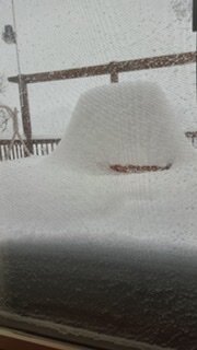
This is what 30” looks like (from 1/2016)
-
Are you ready to shovel 24”? I had that a year ago this weekend. I will pass on that.
-
Check out the mesos (HRRR/RAP) for tomorrow for northern NJ. If this overrunning happens you will be pushing snow from your driveway.
-
That is the flight that will be sampling the western Atlantic for the 0z runs. There are two flights scheduled to go out over the PAC as well. Again the intention is for this data to make it into the 0z model suite. The update for tomorrow is for two flights over the western Atlantic and two over the PAC.
-
I am out in Bethlehem, PA - not really expecting anything. What is crazy are some of those EPS members. By my count 10 of those 50 members would give me 12” +. Brings new definition to the term “Go big or go home.”
-
06z Euro has 3-6” across the area with 6”+ across eastern LI and down closer to ACY in S NJ. Lesser amounts to the N&W.
-
06z Euro shifts east
-
No the Euro output cannot be discounted at this time.
-
The wild card in all this is what will come from the data collected on the recon flight today and the 3 additional flights tomorrow. The data from today’s flight is expected to reflect in the 0z model suite.
-
Yes it is
-
This would come from 20:1 ratios. Do you really think the ratios go that high?
-
Wait to tomorrow when they send out 3 planes. 1 out to the Atlantic and 2 out to the PAC. Another day of model gyrations coming up.
-
18z Euro is 6-12” from the city S and E and 3-6” to the N and W. What is not to like about that?
-
The Euro was the model that went nuts with this one in recent runs. The other models were further east or going that direction. The NAM went big on this this morning for that one run.
-
18z RGEM holds serve from the 12z run. Brings a few inches to the Jersey shore and several inches out on LI.
-
18z ICON still has the storm however it is further east like the rest of the models. Still brings a few inches to coastal areas.
-
On the NHC website they have indicated that they are flying three more winter recon flights tomorrow. One flight will be over the Atlantic and two more over the PAC. This could lead to more model gyrations over the next 24 hours.
-
I got two feet a year ago. I knew I was very unlikely to get anything substantive from this one. This was always going to be a coastal event assuming it would happen. I feel sorry for you guys on the coast with this latest turn of events on the models.
-
Ant - the shortwaves expected to be involved with this system were more completely sampled today. This was noted on this thread earlier. The new data went through the algorithms used by the models. Unfortunately the result of that is what we see.
-
FWIW the 12z ICON is still a good hit for the area with 5-10” along and S and E of I95
-
Huge 100+ mile difference in the new GFS run vs the last run of the Euro. One these is going to cave hard.
-
12z RGEM is slightly east of 6z. Still a good storm for the Jersey shore and out on LI.
-
You do realize that the NAM is not yet in its range - right? You want to start placing more weight on the NAM solutions on Friday.
-
Exactly.
-
If anything close to this were to happen or if the media starts throwing around the numbers we just saw I would not want to even consider the lines that will be forming at the grocery stores near you. The pre-existing supply chain issues would be an additional complication.


