Tatamy
-
Posts
2,583 -
Joined
-
Last visited
Content Type
Profiles
Blogs
Forums
American Weather
Media Demo
Store
Gallery
Everything posted by Tatamy
-

Discussion-OBS snow event sometime between 06z Thu 2/20-12z Fri 2/21?
Tatamy replied to wdrag's topic in New York City Metro
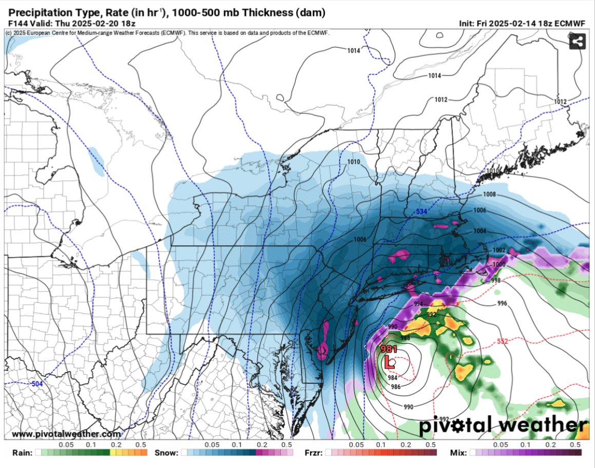
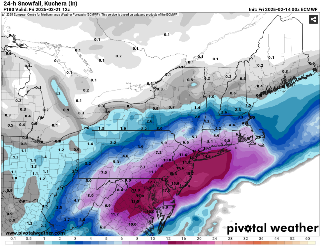
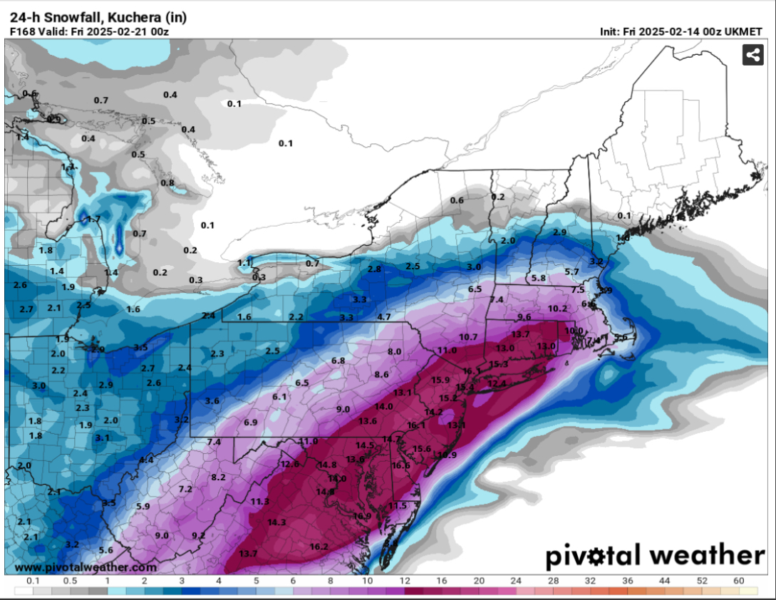
This is one of these be careful for what you wish for types of storms. As shown on the 0z run of the Euro the storm is very intense and would cause major disruption across the area. Strong winds, high tides with coastal flooding and erosion, heavy snows with travel impacts, and a sting jet on the backside would all combine to cause major problems across the area. The 06z run tracked the center further east away from the coast. -
Discussion-OBS snow event sometime between 06z Thu 2/20-12z Fri 2/21?
Tatamy replied to wdrag's topic in New York City Metro
06z Euro is another crusher for the area. -
Discussion-OBS snow event sometime between 06z Thu 2/20-12z Fri 2/21?
Tatamy replied to wdrag's topic in New York City Metro
The ferocity of the bomb that the Euro cooked up tonight can’t be understated. Besides being an all out blizzard for much of the area this system can cause very high tides with major coastal flooding. This system will be sporting an impressive sting jet on its back side as well (especially offshore).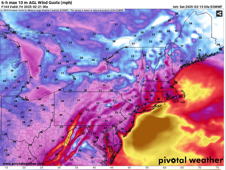
-
Discussion-OBS snow event sometime between 06z Thu 2/20-12z Fri 2/21?
Tatamy replied to wdrag's topic in New York City Metro
Big deformation zone inland to the north and west with this system.
-
OBS-Nowcast for snow 4P Tue 2/11-7A THURSDAY 2/13/25 Mainly NJ-NYC-LI.
Tatamy replied to wdrag's topic in New York City Metro
Snowing 30F -
OBS-Nowcast for snow 4P Tue 2/11-7A THURSDAY 2/13/25 Mainly NJ-NYC-LI.
Tatamy replied to wdrag's topic in New York City Metro
1” new. More than I was expecting. -
February 11th,12th and 13th Event. Little Something Something.
Tatamy replied to Mikeymac5306's topic in Philadelphia Region
Just starting to see a few light flurries over here in Bethlehem Twp. -
February 11th,12th and 13th Event. Little Something Something.
Tatamy replied to Mikeymac5306's topic in Philadelphia Region
Strongly agree that nothing more than perhaps a few flurries makes it to ABE tonight. -
I got a half inch of slop yesterday. No worries because I knew it wasn’t going to produce out here. We all know that we’re not going to get snow from every system that comes. I am very happy that you folks in the city and on the island did well with it. In any case this week looks quite good.
-
We have actually flipped over to light snow here. Looks like just enough to cover up the sleet and ice from last night. Roads are very treacherous. 29 F
-
Freezing drizzle here with 28F. Kudos to the RGEM / Euro for predicting the snow burst that set up over the Metro area. For me the NAM gets the win with no snow and sleet and freezing rain only. I got about 0.25” of sleet and ice. I actually just woke up to the sound of the salt truck in my neighborhood. Many of the models were predicting a tight gradient between snow and no snow over western NJ and that turned out to be the case.
-
Freezing rain. 27/25
-
As of 6 PM you have to be north of I80 if you want to find snow in PA. The only exception is Fort Indiantown Gap which is reporting flurries. Everyone else is reporting ice / sleet/ wintry mix or rain. All Pittsburgh reporting sites are reporting thunderstorms.
-
As of 5PM Johnstown which is an elevated location was reporting Freezing rain. Pittsburgh Intl was reporting a thunderstorm… lol. This is certainly a dynamic system.
-
Yes. I will post a picture in the morning of the final result!
-
Up by you I agree you have a chance.
-
I am bare here. I am figuring maybe a half inch of sleet with some ice to boot here.