BlizzardNole
-
Posts
2,954 -
Joined
-
Last visited
Content Type
Profiles
Blogs
Forums
American Weather
Media Demo
Store
Gallery
Everything posted by BlizzardNole
-
2023 Mid-Atlantic Severe Wx Thread (General Discussion)
BlizzardNole replied to Kmlwx's topic in Mid Atlantic
Solid arc of severe TS warnings from near Toronto/Buffalo all the way back to central Ohio. Gotta wonder what this thing would have done in peak afternoon heating! Hoping to score but it's tough in the rain shadow, especially with NW to SE moving stuff. -
30-day rainfall map really shows the rain hole in our severe drought region. So another overnight disturbance coming? OK southern MD to eastern shore folks enjoy your 2-4 inches. We'll be watering tomorrow morning
-
Everything sliding just to the south, what a shock
-
Just looked at some dreary web cams from OC MD. I would have gladly taken their rainy day for them, but we don't do rainy days here in summer, ever. We do soaking rain and 33 in winter just great, but summer here is so arid.
-
Winners keep winning. When will this ever shift?
-
0.30 total. I was hoping for more but it's better than nothing. It sure seems like there are more extremes of the same places getting big rains over and over and other places nothing.
-
Got about 0.25 from that shower a little while ago. Hoping for more later from that stuff in central VA but will need a little more of a N component
-
Board name checks out Spent a good chunk of time out on the deck as it's fairly nice out. Hoping for rain later tonight
-
Are you N of Baltimore? I've got a toasty 89/73 right now
-
2023 Mid-Atlantic Severe Wx Thread (General Discussion)
BlizzardNole replied to Kmlwx's topic in Mid Atlantic
Night thunderstorms with lots of lightning are my favorite. We used to go to near Atlantic Beach, southern outer banks and that place was ideal for night storms. One time we had one that went on for an hour and there was so much lightning it was like a strobe light.- 2,785 replies
-
- 3
-

-
- severe
- thunderstorms
- (and 3 more)
-
Time to think cold. What is your favorite snow memory?
BlizzardNole replied to ldub23's topic in Mid Atlantic
I was passing by there last June and went in look around and saw my old house at the intersection of Kettering and Bennington Drives. There used to be a big open field right next to us in the 70s that we had fun times in. Now it's all houses. I noticed a lot of retiree-aged people around and the yards looked really nice. Older folks love the gardening! -
Time to think cold. What is your favorite snow memory?
BlizzardNole replied to ldub23's topic in Mid Atlantic
Best big event: Blizzard of '79 in hardest hit Calvert County. Was like a hurricane of snow where at times we could not see the woods less than 100 feet from the house. Total was 30-36 with 6-plus foot drifts. Best smaller event: Jan. 1978 in Kettering, MD with forecast of rain developing in the evening and continuing overnight, possibly beginning as a brief period of snow. Got a totally unexpected front end thump with about 6 inches in just 2-3 hours, then drizzle after. Best positive bust ever -
Finally got my first thunderstorm of the summer! Some good lightning and thunder, and 0.6 which is the most in one day in many many weeks. It may not sound like much but for here it is a deluge. Puts July at 1.5 which is already better than the extremely dry May and June.
-
Nothing here yet as everything seems to be sliding just south. We'll see if my rain shadow lucks out with some scraps.
-
Congrats on the move and getting out of the disgusting desert that you left behind
-
Just looked at Key West -- lows the last three mornings 86, 87 and 87 with HX rarely below 100 and there are some water temps as high as mid-90s! That is sick. Better hope a tropical cyclone does not get a taste of those water temps. Hoping for a rare thunderstorm the next couple of days but the LWX disco doesn't make me optimistic with the typical west today and east tomorrow.
-
Article below says this is the 2nd driest year ever for Mont Co, and my spot is the worst of all as places nearby have had downpours that I missed. I do water my flower beds and pots but I'm letting the lawn go dormant. WTOP Article on Drought
-
Well here we go again with likely wording for storms Fri-Sat. Let's see if I can top the big 0.05 I got from the last "event"
-
Well the rain may have failed yet again but the front delivered with nice weather today. 85/63 with clean air and a breeze. Not bad for July 10
-
Completely whiffed AGAIN with just enough to barely wet the ground. It split right over me then formed a solid line 3 miles to my east like it does over and over. I wish I took screenshots of radar because it's hard to believe. My wife just got back from Gaithersburg which is outside the desert zone and said it was pouring there. JESUS CHRIST this place sucks. I can't wait to move out of this SH!THOLE in a couple more years.
-
A rainfall map showing the stark differences in totals in our region from June 1 thru end of today will be unbelievable. Mostly cloudy and humid as I did some gardening work. I'll be running the sprinklers tomorrow morning
-
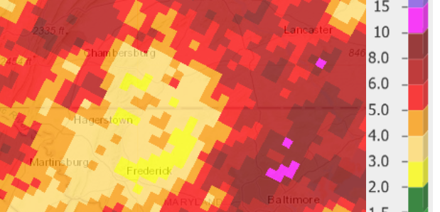
.NEAR TERM /THROUGH TONIGHT/... MID-MORNING UPDATE: CONFIDENCE IS INCREASING THAT THAT THE GREATEST THREAT FOR SEVERE THUNDERSTORMS, AND ESPECIALLY FLASH FLOODING MAY BE FROM THE BALTIMORE METRO AREA NORTH AND EAST. Well I and my fellow desert rats are just shocked! My bar is a half inch and one rumble of pity thunder but that will take some luck
-
We went to the Tarara winery near Leesburg last night and the ground was dry as a bone there - even worse than my micro-desert. I really miss the zoomable iweather rainfall map! I don't even use it any more.
-
Let's see if my drought-stricken area can finally cash in. I have just 0.85 for July after a very dry June. I also have not seen 1" in a day in ages. This just feels like another 0.2 or less deal.
-
Hey LWX, I fixed tomorrows FFW for you: