wxsniss
-
Posts
5,788 -
Joined
-
Last visited
Content Type
Profiles
Blogs
Forums
American Weather
Media Demo
Store
Gallery
Everything posted by wxsniss
-
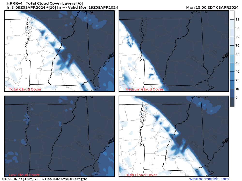
Great luck everyone! Heading out from Boston soon, target Newport. 9z HRRR looks great:
-
Same exact plan Agree I think cloud cover will be a thin veil at most + we'll be far enough east that Newport vs. Colebrook should work. Defaulting to Newport given the extra seconds of totality. I'm so nervous just about getting there leaving Boston at 8am. Still can't believe New England may have one of the the best patches of viewing on the planet... I'll PM you my cell #
-
Totally sympathize... at one point, I naively planned to bring my 1 and 4 yo... then wisened up not to squander a once-in-a-lifetime 3 minutes to a "daddy my glasses keep falling off" tantrum lol Thankfully the grandparents will babysit
-
BTV did the same, pretty cool... For Monday, trends in guidance continue to be for a slightly faster arrival of high clouds which will likely provide a filtered view of the eclipse for the North Country and Champlain Valley, while east of the Greens should remain more clear through 4 PM before the clouds move in. 925mb temps of +6-8C and steep low level lapse rates would normally support highs in the low/mid 60s but with totality occurring right around normal peak heating backed off on high temps a few degrees for 55-60. We`ll additionally see a brief drop in temps of 4-6 degrees during totality as well, which will be cool to observe. Mid/high clouds stick around Monday night with no precipitation expected and low temps milder ranging through the 30s. And thanks for pinning this thread!
-
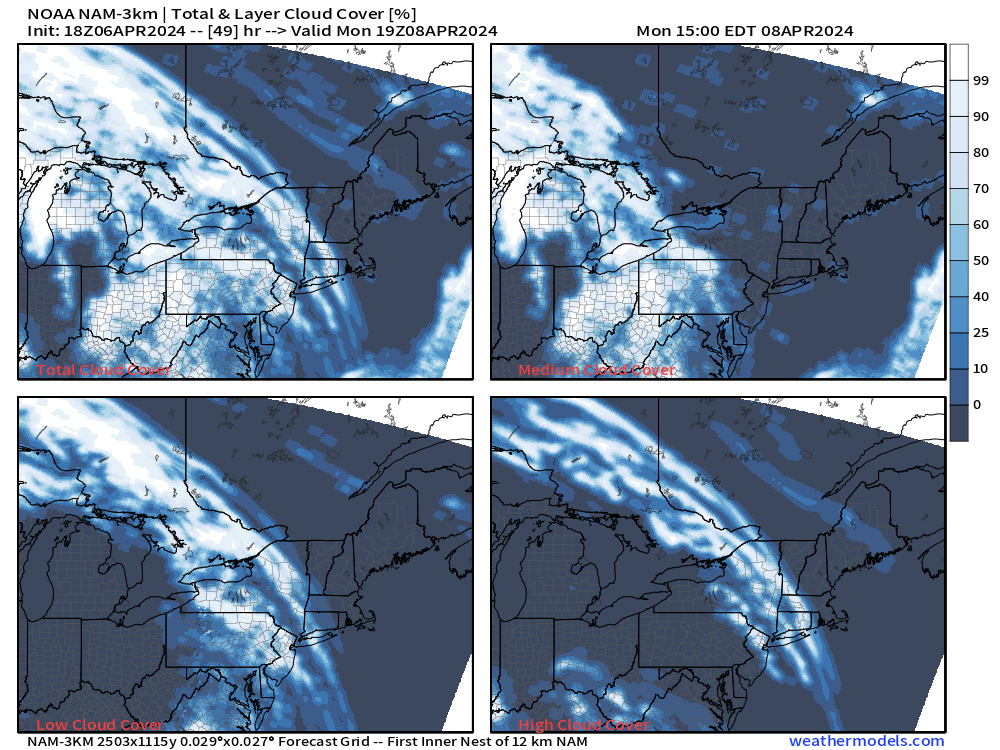
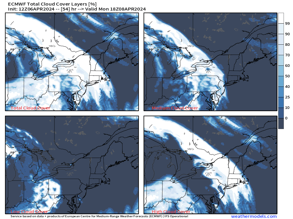
Model Maps > Model Animator > Parameter --> select Cloud Cover Only available on ECMWF and 3k NAM You can find Cloud Cover for GFS, GEFS, 12k NAM on Pivotalweather
-
Yeah the at-worst plan is pull over on I-91 breakdown lane, sit on grass. I'm nervous even that option won't be possible if the breakdown lane is already a parking lot. But hopefully 7 hours drive from Boston is enough to reach Newport and stage someplace more reasonable. So happy you're doing New England instead of Eagle Pass! Unbelievable that NNE will be the best viewing in the country. A month ago I was bracing myself for a washout. 18z NAM as you wrote above looks great...
-
Am I being totally ridiculous thinking at absolute worst you could just pull over on I-91 (or whatever road you're on)? My thinking is just get to the destination in time (and I'm increasingly nervous of that leaving Boston 8am) and the rest is gravy... I too remember the drive back to airport from Gallatin was surprisingly OK.
-
I linked a watch event at Newport, VT earlier in the thread... my plan is to leave Boston 8am, 93 to 91 to Newport. At the very least will stage on southbound 91 and just pull over on the interstate. A bit nervous what cloud cover over pretty much the rest of the nation's path will do to crowd surge and driving on Monday, but I'm hoping 4 hours extra buffer will be enough for an ordinarily 3.5 hour drive.
-
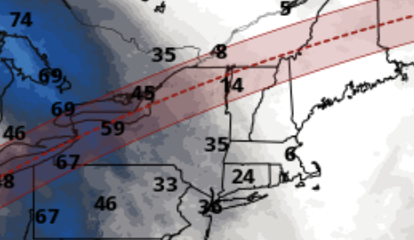
12z Euro... note this is for 18z (2pm) and 21z (5pm)... ie. northeast VT, northern NH, all ME should be excellent:
-
19z NBM (blue/grey is cloud cover, white is clear with % cover shown): Further northeast seems better at this point... Euro has the cloud cover a bit further northeast than the NBM and GFS/GEFS as wxeyeNH posted above. So if it's a no-cost decision between the 2 destinations, I'd go further northeast. But see what others here say...
-
GFS/GEFS holding steady for VT/NH/ME BTV: As of 415 PM EDT Friday...Surface and upper level ridges remain over the region for Monday, leading to pretty ideal viewing conditions for the eclipse Monday afternoon. Some high clouds will approach from the southwest, but at most some high clouds around. Maximum temperatures will range through the 50s.
-
It's like getting 99% instead of 100% of the numbers right on a lottery ticket. Those who haven't witnessed totality might extrapolate incrementally, but it's infinitely different. It's like the minute before or after, cool but no big deal. 2017 eclipse was easily one of the most amazing and freaky things I've ever seen. Not at all about money or hype... quite the contrary. You could be as in awe just standing in an open field, for free. Aside from the otherworldly sight, it's rare we get to witness with our own eyes just how small we really are.
-
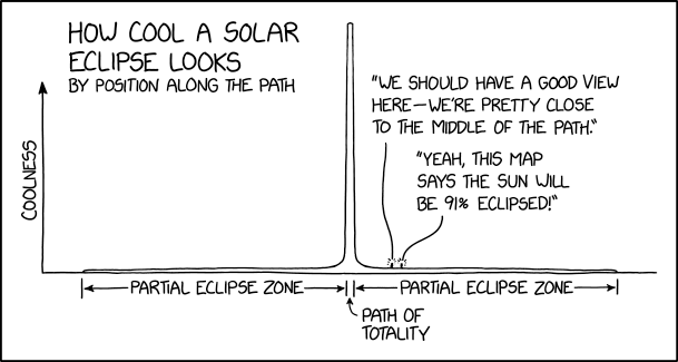
"A partial eclipse is like a cool sunset. A total eclipse is like someone broke the sky." Hat tip: https://xkcd.com/2914/
-
Similar sensation to 2011… almost like an undulating floor as if a heavy bouncing truck was driving by And the fun and typical experience for these parts: going from “what the hell was that” to seeing all the breaking reports
-
Wow felt that! 10:28ish
-
I will say based on my experience in Gallatin TN 2017 (crowd of thousands in large sports fields), hearing the wave of shrieks sweep across a crowd of thousands does add to the experience. If you can get to an event and have the time for a slow exit, it can be very memorable. But yeah if not committing to an event: I'm hoping to pull over southbound I-91 or at least stage minutes from the highway. Hoping that won't be policed for the 3.5 minutes of totality and 30 min before, as I imagine many many will be doing the same.
-
Yeah I'm nervous about that too, but YOLO rules very much apply lol I figure adding 1.5 hours to normal drive time would make it. Obviously will also fill up on gas and stage southbound before eclipse. I was in Gallatin TN north of Nashville for 2017, easily one of the most breathtaking things I've ever seen... traffic heading back to airport wasn't that bad actually.
-
So helpful, really appreciate the local knowledge! And great idea to look at sunny distant hills from within totality. We'll be on a tight schedule to get back to Boston by 8pm, so I'm planning to stage on southbound direction (or just near an on-ramp) on I-91. And planning to just pull over on side of road (or even on southbound I-91) if necessary. I imagine I won't be the only one pulling over on the interstate.
-
Good bet given guidance at this range Jerry... northeast looks like it actually has a chance sitting east of ridge. I'll be driving somewhere with my wife. Any thoughts from anyone on this plan? I'm thinking Newport, VT... 3.5 hr drive during weekday rush hour, so we'll plan on a 6 hour drive up: Drive up 93N, onto 91N at St. Johnsbury. Stay on 91 and get car to southbound direction before eclipse and that way can immediately hit road after. At worst might even just pull over side of 91 southbound... There is an actual organized event, but I imagine it'll be impossible to enter: https://www.discovernewportvt.com/eclipse/
-
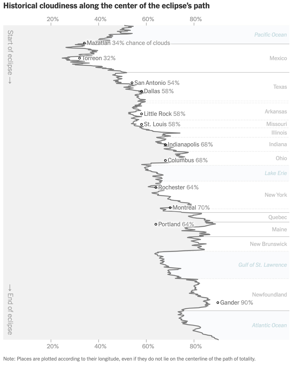
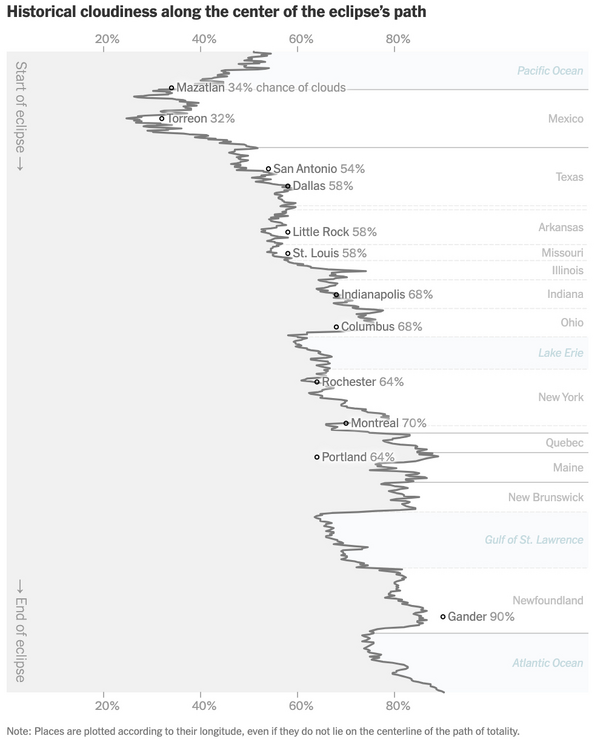
https://www.nytimes.com/interactive/2024/science/solar-eclipse-cloud-cover-forecast-map.html
-
It was a Flop... February 2024 Disco. Thread
wxsniss replied to Prismshine Productions's topic in New England
Hits the spot. Winter and all its meteorological chases and thrills have been a reliable escape for folks here for as long as we can remember (for me, since moving here in 1993, so my expectations were warped from the start). The past 2 years? The only redeeming experience was a few hours after the CF passed through on Jan 7... first time my toddler witnessed heavy snow and he was absolutely ecstatic. Here's how it would look if we do in fact sweep the rest of the season and don't hit 4" before mid Dec 2024... depressing: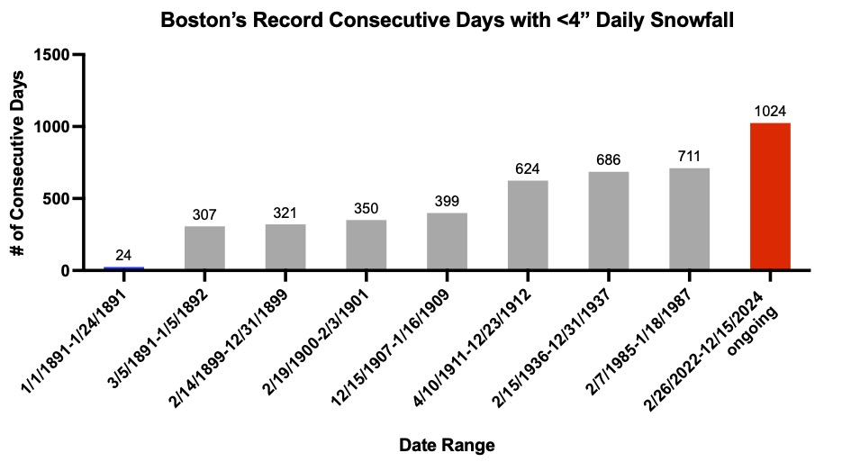
-
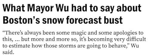
Pseudo-science. If the mayor is going to speak broadly for meteorologists, would be nice if she said something like: "This was a more difficult forecast than usual, and meteorology can be an extremely challenging science. While forecasting has improved significantly, it still has imperfections. Also we are putting the horse down."
-
Interesting... she's a politician and not a scientist, but I'm sure the thought crossed people's minds here too... as with lots of things here, too microscopic a sample size to say anything conclusively (and not intending to start a whole CC debate here, just relaying a reaction while the puddles are still drying): “I think it goes to show not only is our climate changing in general that we haven’t had a significant snowstorm now in more than two years, but also the predictability of the weather — every storm can change so quickly on its path, the projections, the amounts,” Wu said. https://www.boston.com/news/weather/2024/02/13/what-mayor-wu-had-to-say-about-bostons-snow-forecast-bust/?p1=hp_featurestack
-
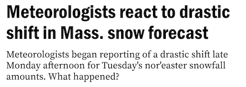
Congrats to those in southeast MA right now! Feels like most areas of southern/eastern SNE have had some seasonal redemption with this storm. Boston metro a notable exception. Not even a consolation inch for this "snow emergency". The "what happened" headlines beginning, with several met thoughts here, many saying they would have made the same exact forecast given the data until Monday afternoon: https://www.boston.com/weather/weather/2024/02/13/meteorologists-react-drastic-shift-mass-snow-forecast/?p1=hp_primary
-
Hyannis, pounding snow right at the water... https://masswebcams.com/hyannis-harbor-webcam/