NorthShoreWx
-
Posts
5,506 -
Joined
-
Last visited
Content Type
Profiles
Blogs
Forums
American Weather
Media Demo
Store
Gallery
Everything posted by NorthShoreWx
-
Another winter when January snow hung on for weeks: Smithtown Snow Depth 2010-2011 Snowdepth @ ~8AM 12/14/10 1 12/15/10 1 12/16/10 T 12/17/10 T 12/18/10 T 12/19/10 0 12/20/10 0 12/21/10 0 12/22/10 0 12/23/10 0 12/24/10 0 12/25/10 0 12/26/10 0 12/27/10 12 12/28/10 10 12/29/10 9 12/30/10 8 12/31/10 8 01/01/11 7 01/02/11 4 01/03/11 3 01/04/11 3 01/05/11 2 01/06/11 2 01/07/11 2 01/08/11 4 01/09/11 4 01/10/11 4 01/11/11 4 01/12/11 19 01/13/11 18 01/14/11 17 01/15/11 16 01/16/11 15 01/17/11 14 01/18/11 15 01/19/11 11 01/20/11 10 01/21/11 14 01/22/11 13 01/23/11 13 01/24/11 12 01/25/11 12 01/26/11 25 01/27/11 24 01/28/11 23 01/29/11 22 01/30/11 22 01/31/11 21 02/01/11 22 02/02/11 21 02/03/11 20 02/04/11 18 02/05/11 18 02/06/11 16 02/07/11 15 02/08/11 14 02/09/11 13 02/10/11 13 02/11/11 13 02/12/11 13 02/13/11 12 02/14/11 11 02/15/11 11 02/16/11 11 02/17/11 10 02/18/11 9 02/19/11 7 02/20/11 6 02/21/11 10 02/22/11 10 02/23/11 8 02/24/11 7 02/25/11 4 02/26/11 3 02/27/11 2 02/28/11 2 03/01/11 T 03/02/11 T 03/03/11 T 03/04/11 T 03/05/11 T 03/06/11 T 03/07/11 0 03/08/11 0 03/09/11 0 03/10/11 0 03/11/11 0 03/12/11 0 03/13/11 0 03/14/11 0 03/15/11 0 03/16/11 0 03/17/11 0 03/18/11 0 03/19/11 0 03/20/11 0 03/21/11 0 03/22/11 0 03/23/11 0 03/24/11 2 03/25/11 T
-
Tis the season when it can be 50° or higher and then snowing 6 hours later. From about mid-February on its fairly typical.
-
Excellent choice. Sending the Triple Triple Edit: Although this Red Breast is pretty tasty
-
Gift cards and scotch are in the mail for the three shadow mods.
-
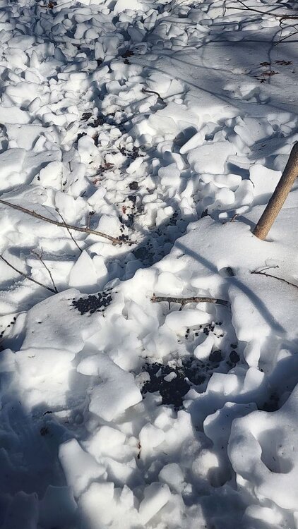
They ate my picnic table.
-
I didn't realize there was any place free of them on LI. Can't swing a dead cat without hitting one here. And I can confirm that they shit where they sleep.


-
He changed his name to PhiEaglesfan
-
Understatement of the year.
-
I had snow on the ground every day of March 2015.
-
light snow, 32° N Smithtown Mainly graupel. Got a dusting
-
The mean temperature here since December 1 (12/1 - 2/9) has been 30.4° The mean for the past 18 days has been 20.0°
-
Edit: somehow I forgot this one:
-
How is this evidence of anything? At least the colors are pretty.
-
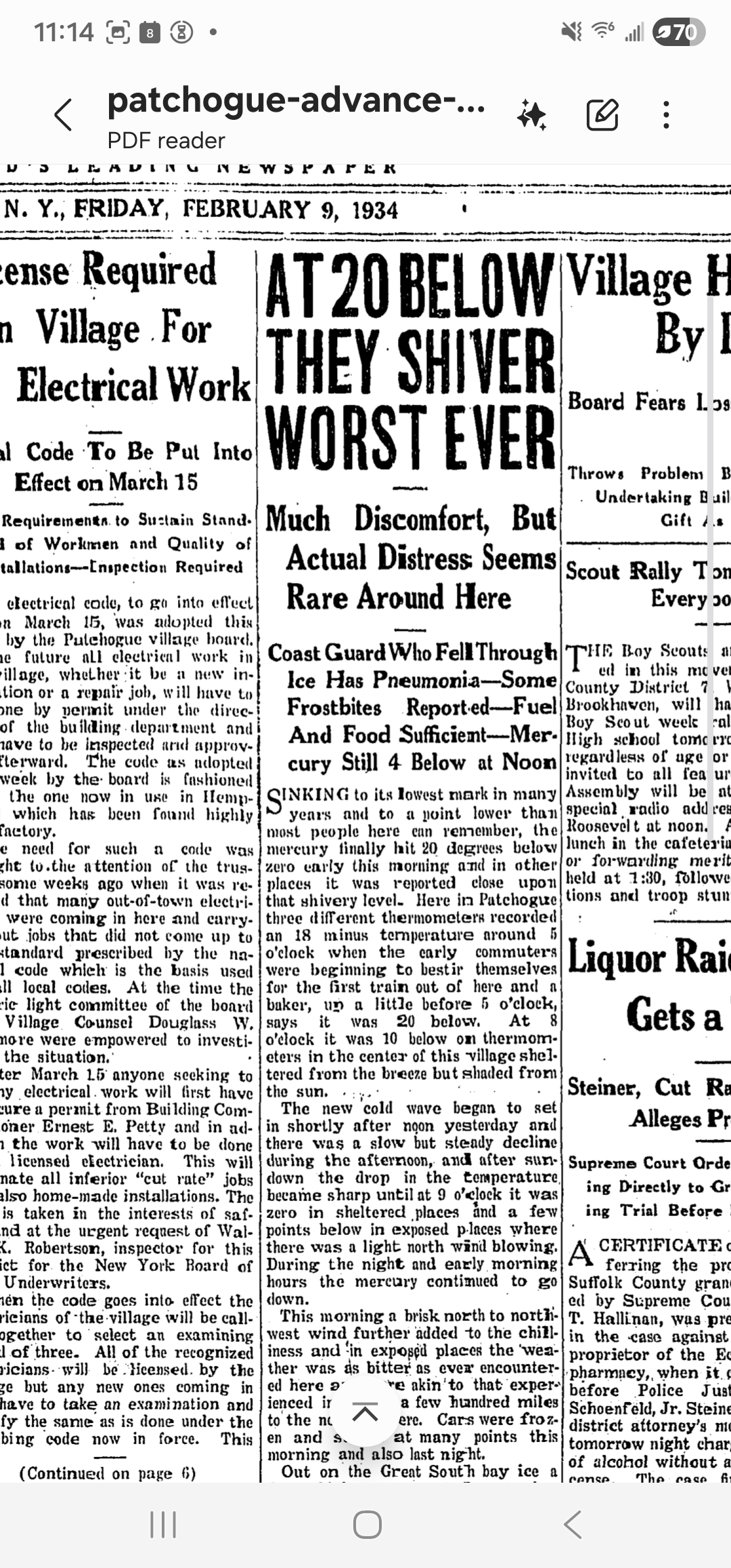
Ironic. In 1934 at -20, "Much discomfort, but actual distress seems rare..." Cut to 2026, +3, little discomfort, but distress is through the roof.
-
92 years ago @TWCCraig
-
There was CAA in 1934. There were reports on LI in local papers as low as -20. Strongs Neck (i.e., "Setauket") is a windy spit substantially surrounded by water.
-
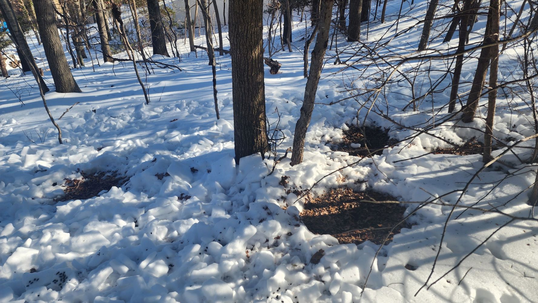
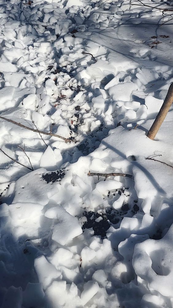
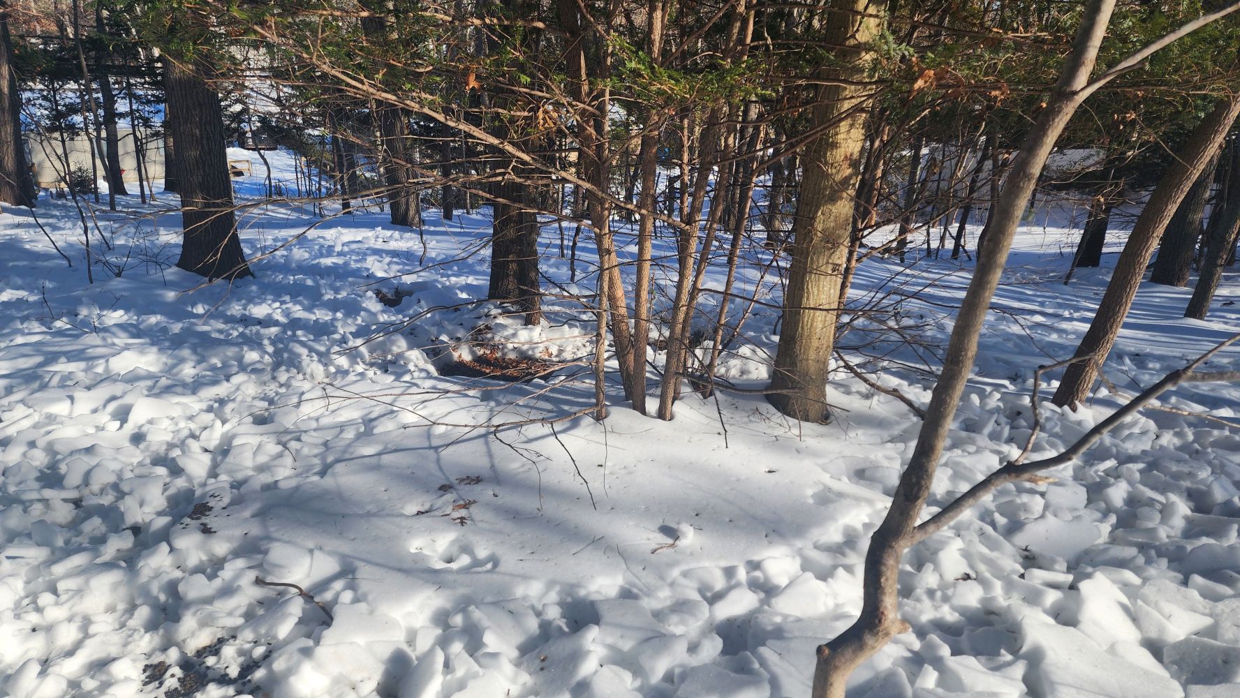
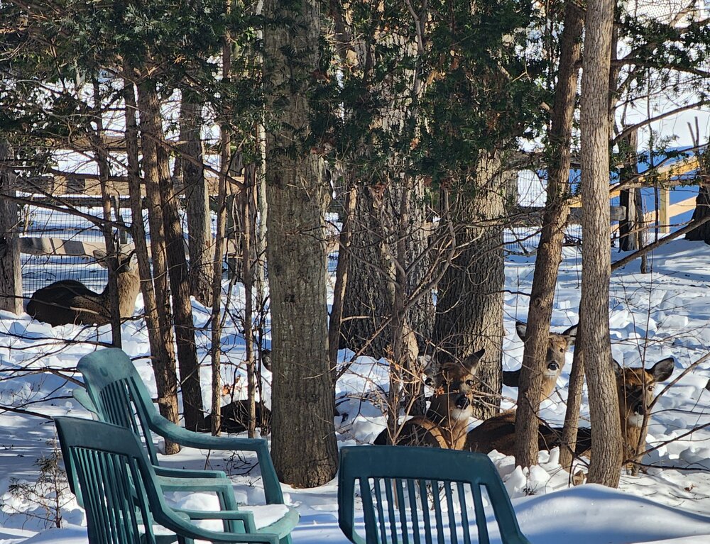
These guys have been squatting in my yard for months. The words spreading and we have 6 of them this morning. There's 5 in this photo and the 6th out of frame to the left.
-
Low here was 4⁰ (3.6⁰) Yesterday's range was 26/6 (5.5). Snowfall was 0.6" (event total 0.9"). Seasonal total snowfall is 29.3" Snow depth is 8"
-
Block Island looks pretty cool at the moment https://nationalwebcam.com/
-
Was wondering if DIX being down is affecting the solutions. Sounds like it could be.
-
26/23 at midnight S- pcpn very light. 0.3" new snow, Snow depth 8" Question: do any of the short term models input any Nexrad data?
-
Thanks for sharing that memory. Do you have any photos from that? The ones I have are here: https://www.northshorewx.com/19780207.html The storm did a loop south of LI, but talk about a benchmark track:
-
Smithtown 8:30 pm 28/20 Flurries Due to the developing flizzard emergency, we are suspending the hourly ISP 1978 re-enactment. Here for your perusal is the complete set of metars (decoded) from that once in a lifetime event: KISP - Islip, NY Date Time (EST) Temp Dew Point Humidity Sea Level Pressure Visibility Wind Dir Wind Speed Gust Speed Events 2/6/1978 12:00 AM 23.0 3.0 42 30.26 7.0 North 11.5 - 2/6/1978 1:00 AM 26.1 1.9 35 30.20 7.0 NNE 17.3 - 2/6/1978 2:00 AM 25.0 1.0 36 30.22 7.0 NNE 13.8 - 2/6/1978 3:00 AM 25.0 19.9 81 30.19 2.0 NE 15.0 - Snow 2/6/1978 4:00 AM 25.0 19.9 81 30.15 3.0 NE 16.1 - Snow 2/6/1978 5:00 AM 25.0 21.0 85 30.12 2.0 NE 23.0 - Snow 2/6/1978 6:00 AM 24.1 19.0 81 30.09 2.0 NNE 23.0 - Snow 2/6/1978 6:25 AM -9999.0 -9999.0 N/A 30.08 1.0 NNE 23.0 - 2/6/1978 7:00 AM 24.1 19.9 84 30.07 0.5 NNE 23.0 - Snow 2/6/1978 8:00 AM 24.1 21.0 88 30.01 0.2 NE 25.3 - Snow 2/6/1978 8:11 AM -9999.0 -9999.0 N/A 30.00 0.5 NE 20.7 - 2/6/1978 9:00 AM 26.1 21.9 84 29.99 0.2 NE 21.9 - Snow 2/6/1978 9:15 AM -9999.0 -9999.0 N/A 29.94 0.2 NE 19.6 34.5 2/6/1978 10:00 AM 27.0 24.1 89 29.94 0.1 NE 23.0 34.5 Snow 2/6/1978 11:00 AM 27.0 25.0 92 29.88 0.1 NNE 25.3 40.3 Snow 2/6/1978 12:00 PM 27.0 25.0 92 29.78 0.1 NNE 23.0 34.5 Snow 2/6/1978 12:05 PM -9999.0 -9999.0 N/A 29.74 0.0 NE 29.9 39.1 2/6/1978 1:00 PM 27.0 26.1 96 29.69 0.0 NNE 32.2 41.4 Snow 2/6/1978 2:00 PM 28.0 26.1 92 29.63 0.0 NE 32.2 40.3 Snow 2/6/1978 3:00 PM 28.9 28.0 96 29.54 0.0 NE 40.3 56.4 Snow 2/6/1978 4:00 PM 30.0 28.0 92 29.49 0.0 NE 46.0 59.8 Snow 2/6/1978 5:00 PM 30.0 27.0 88 29.46 0.0 NE 28.8 47.2 Snow 2/6/1978 6:00 PM 28.0 27.0 96 29.44 0.1 NE 34.5 - Snow 2/6/1978 7:00 PM 27.0 26.1 96 29.40 0.0 NE 38.0 46.0 Snow 2/6/1978 8:00 PM 26.1 26.1 100 29.34 0.0 North 28.8 43.7 Snow 2/6/1978 9:00 PM 21.9 19.9 92 29.30 0.0 North 28.8 48.3 Snow 2/6/1978 10:00 PM 23.0 21.9 96 29.26 0.1 North 23.0 40.3 Snow 2/6/1978 10:30 PM -9999.0 -9999.0 N/A 29.24 5.5 NNE 23.0 40.3 2/6/1978 11:00 PM 32.0 30.0 92 29.24 0.6 NNE 25.3 - Snow 2/7/1978 12:00 AM 33.1 30.9 92 29.24 0.8 NNE 28.8 - Snow 2/7/1978 1:00 AM 33.1 30.9 92 29.28 0.2 NE 18.4 - Snow-Thunderstorm 2/7/1978 1:05 AM -9999.0 -9999.0 N/A 29.26 0.2 NE 19.6 27.6 2/7/1978 2:00 AM 30.0 28.9 96 29.28 0.1 NNE 26.5 - Snow 2/7/1978 3:00 AM 27.0 26.1 96 29.31 0.3 NNE 28.8 - Snow 2/7/1978 4:00 AM 25.0 24.1 96 29.33 0.2 NNE 28.8 40.3 Snow 2/7/1978 5:00 AM 24.1 23.0 96 29.35 0.2 NNE 25.3 - Snow 2/7/1978 5:05 AM -9999.0 -9999.0 N/A 29.35 0.4 North 23.0 34.5 2/7/1978 6:00 AM 23.0 21.0 92 29.38 0.5 North 23.0 - Snow 2/7/1978 7:00 AM 24.1 19.9 84 29.40 5.0 North 23.0 29.9 Snow 2/7/1978 8:00 AM 24.1 19.9 84 29.43 1.0 North 23.0 - Snow 2/7/1978 9:00 AM 25.0 21.0 85 29.47 0.5 North 26.5 - Snow 2/7/1978 9:10 AM -9999.0 -9999.0 N/A 0.00 0.1 NW 19.6 26.5 2/7/1978 10:00 AM 24.1 21.0 88 29.50 0.1 NNW 20.7 27.6 Snow 2/7/1978 10:04 AM -9999.0 -9999.0 N/A 0.00 0.6 NNW 20.7 27.6 2/7/1978 11:00 AM 24.1 21.0 88 29.52 0.1 NNW 20.7 - Snow 2/7/1978 12:00 PM 24.1 21.9 91 29.55 0.1 NNW 25.3 35.7 Snow 2/7/1978 1:00 PM 25.0 21.9 88 29.57 0.2 NNW 20.7 35.7 Snow 2/7/1978 1:15 PM -9999.0 -9999.0 N/A 29.57 1.0 NW 23.0 36.8 2/7/1978 2:00 PM 26.1 21.9 84 29.60 0.2 NNW 23.0 38.0 Snow 2/7/1978 3:00 PM 26.1 21.9 84 29.63 0.2 NNW 23.0 - Snow 2/7/1978 3:30 PM -9999.0 -9999.0 N/A 0.00 3.0 NNW 23.0 32.2 2/7/1978 4:00 PM 26.1 24.1 92 29.66 1.0 NW 20.7 - Snow 2/7/1978 4:10 PM -9999.0 -9999.0 N/A 29.68 5.0 NW 20.7 - 2/7/1978 5:00 PM 26.1 24.1 92 29.71 5.0 NNW 20.7 28.8 Snow 2/7/1978 6:00 PM 27.0 24.1 89 29.76 5.0 NNW 23.0 31.1 Snow 2/7/1978 7:00 PM 26.1 23.0 88 29.79 10.0 NW 17.3 - Snow 2/7/1978 8:00 PM 26.1 21.9 84 29.83 10.0 NW 18.4 - 2/7/1978 9:00 PM 26.1 23.0 88 29.86 10.0 NW 19.6 - 2/7/1978 10:00 PM 26.1 23.0 88 29.90 10.0 NW 15.0 - 2/7/1978 11:00 PM 26.1 21.9 84 29.94 10.0 NW 15.0 -
-
26" (25.9", I think)
-
8PM (1978): Temperature dropped. Viz did too: METAR KISP 070056Z 00025G38KT 0SM +SN BLSN VV000 M04/M04 A2934 RMK SLP936