

NorthShoreWx
-
Posts
5,510 -
Joined
-
Last visited
Content Type
Profiles
Blogs
Forums
American Weather
Media Demo
Store
Gallery
Everything posted by NorthShoreWx
-
Manhasset Bay Live: https://baycam.manhassetbayyc.org:37777/view/view.shtml?id=288&imagepath=%2Fmjpg%2Fvideo.mjpg&size=1
-
The water at Kings Point is either right at the freezing point (for western LI Sound salinity) or already frozen. Bridgeport and New Haven are getting close: https://www.weather.gov/okx/Marine_Obs.html
-
No thanks. There's enough of you doing that already. My point was, that's far from a clear swing and a miss signal.
-
Do they still dump it in the river?
-
It's implied. Personally, I find the actual QPF maps more helpful at this timeframe.
-
That's a lot of QPF for an ensemble mean 5 days out.
-
I'd be more worried about ice damming than structural issues, unless your house is framed with balsa wood. Based on the temperature forecast and the amount of snow on my roof, I am worried about ice damming.
-
I'm going to have to check, but I'm not sure if I've ever had more than 10:1 (if that) in a 10" or greater snowfall. It might be a consequence of being surrounded by water, and sometimes the wind.
-
Yes. The SWE from this one might be high percentile for local snowstorms. Took me and my son about 3 hours to shovel the driveway.
-
North Smithtown, NY Storm Total 11.4" LE: 1.90" from melted core (4" gage catch was 1.33") Season total to date 28.4"
-
-
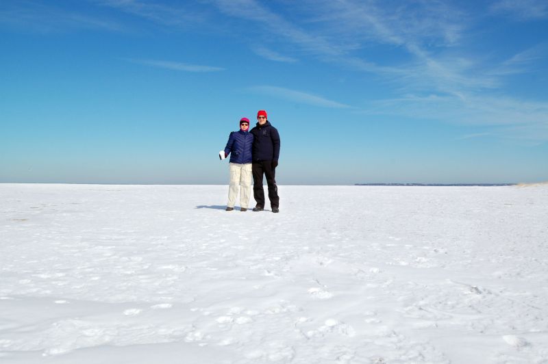
Back bays are easy. I want to see the sound freeze again. That was very cool in 2015. Posed out on the ice with my wife and it looked like we were standing on the Antarctic ice sheet.
-
Here's a couple:
-
Extreme Cold, Snow & Sleet: SECS 1/24 - 1/26
NorthShoreWx replied to TriPol's topic in New York City Metro
I'm in the 'wipe the board on phase changes' camp. Here is an example scenario illustrating some of the possible outcomes of only wiping once per 24 hours and not at phase changes. Some of it isn't that far off from the reality of yesterday's event: - location 1 gets 8" of low water content fluffy snow and the storm ends. - location 2 gets the same 8" of low water content fluffy snow which then switches to sleet and 2" of sleet accumulate on top of it. By the end of the storm later that day the snow depth has compressed to 8" (or less). - location 3 gets 2" of sleet first, followed by the same 8" of fluffy snow. - locations 1 and 2 report snowfall as the maximum depth of 8" - location 3 reports a maximum depth of 10" as the daily snowfall. Location 3 no doubt had the deepest snow depth. Location 2 and 3 had the exact same amount of snow and sleet, but a different entry in the climate record. Location 2 had more than twice as much frozen precipitation as location 1, but the only way to tell that is from the SWE. They each report the same amount of snow and sleet. On thing that stands out as being lost in these examples is the standard that snowfall includes snow and sleet. Does it really include sleet for location 2? -
Extreme Cold, Snow & Sleet: SECS 1/24 - 1/26
NorthShoreWx replied to TriPol's topic in New York City Metro
A couple of my half-baked thoughts about the modeling in general: Good job for the most part with QPF (not withstanding the bizarre ukmet qpf hole and some other model run faux pas) Decent job with the sleet extent once they caught on to the warm nose. I thought I had a good handle from the modeling on what was going to happen in this region, and that was correct. I had a lot less confidence in what was going to happen in the Mid-Atlantic region. Seemed like more variation in the modeling for there, although I didn't look at it as closely. Most modeling held off too long on flipping LI back to snow last night. I had the impression we'd wake up to some freezing drizzle and temps between 25 and 30; 18⁰ and snowing is what verified. At least on the north shore we were going back to snow around 10pm. My loosely considered model consensus had a substantial warm nose persisting through most of the overnight. Overall for my insulated little corner of the world, my landscape looks very much like what I was expecting it to a few days ago...moreso than usual so subjectively, the modeling was very good. The NWS did a good job too. They more or less stayed with a forecast that eventually verified well through many forecast cycles. Complaining about tweaks like adjusting P&C totals from 9 to 14 inches down to 7 to 13 inches is petty, especially when both pretty well reflected the eventual outcome. -
That's a deeper low than in 1978, but there was something like a 1040 high over Quebec in 78. The closest thing I've seen to the winds in 78 was 12/26/2010, but we had at least twice as much snow in 78 vs 2010. Only about 12" here in 2010.
-
I have an intelligent 11"
-
Record is 16 days in Jan - Feb 1961
-
Nice mood flakes continuing this morning. Ongoing snowshowers for the past few hours have added a little fluff on top of yesterday's snowfall. 18⁰ So after all the hand-wringing and model psychosis, who is dissatisfied with this one?
-
Some might argue it already has after yesterday.
-
1/25 snowfall here: 11.0" (includes sleet). 1.8" fell after mixing began.
-
-
Moderate snow shower now. Looks like a little sound enhancement too. 24⁰
-
Ditto. 26⁰
-
I was surprised to look out and see real snowflakes swirling all around for a few minutes. Almost moderate snow. Back to a light pixie dust mix now.


