NorthShoreWx
-
Posts
5,510 -
Joined
-
Last visited
Content Type
Profiles
Blogs
Forums
American Weather
Media Demo
Store
Gallery
Everything posted by NorthShoreWx
-
Extreme Cold, Snow & Sleet: SECS 1/24 - 1/26
NorthShoreWx replied to TriPol's topic in New York City Metro
Glad to hear he's still at it. -
Extreme Cold, Snow & Sleet: SECS 1/24 - 1/26
NorthShoreWx replied to TriPol's topic in New York City Metro
I don't think the sleet will freeze into a brick here. GFS temps here during the storm get no higher than 25⁰ and on the NAM 23⁰. The smallish warm nose on both is above 800 millibars and below that falls quickly well below freezing and stays that way all the way to the surface. If you keep a bag of ice cubes cold enough, they don't stick together. Plus, I anticipate it will be more sleet snow mix (back and forth for a few hours) than pure sleet. I agree with you that this is going to be a good one either way. -
Snowmegaly
-
Extreme Cold, Snow & Sleet: SECS 1/24 - 1/26
NorthShoreWx replied to TriPol's topic in New York City Metro
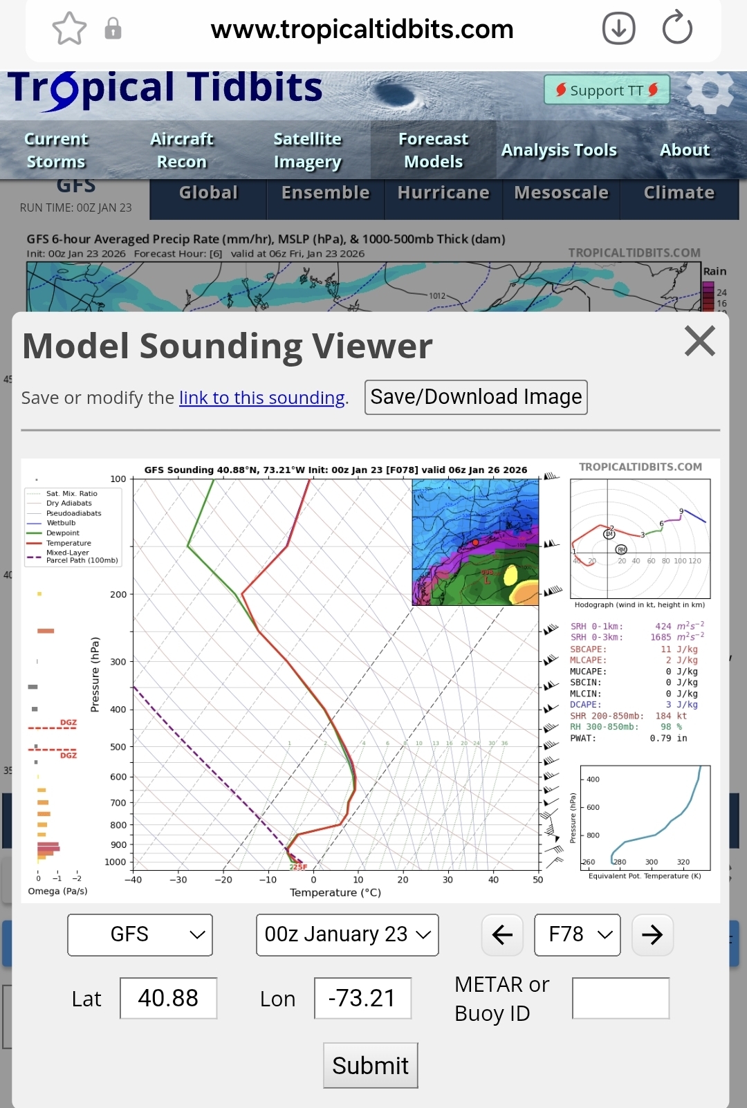
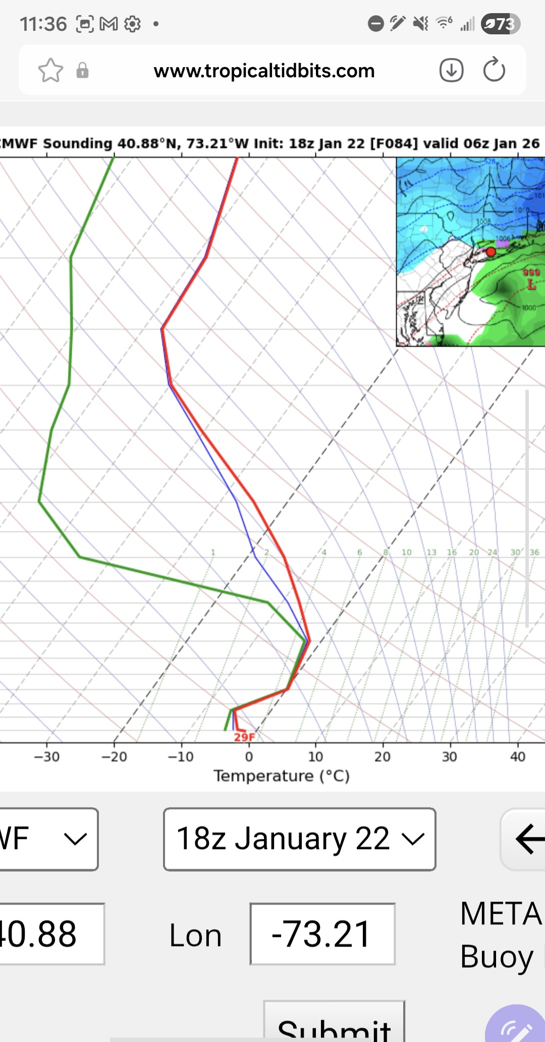
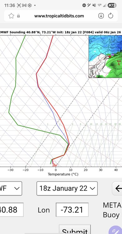
I'm pretty confident it will taint, but I think the somewhat weak consensus in this thread is overestimating the magnitude of it. I looked at model soundings last night that showed the warmest part of the column at about -2C at my location aligned with a p-type map where we were deep into the purple. Gives me more confidence in the NWS sticking to their guns. The 3rd party p-type maps are often bizarre. I'm eager to see NAM soundings once most of the storm gets within 60 hours. -
Extreme Cold, Snow & Sleet: SECS 1/24 - 1/26
NorthShoreWx replied to TriPol's topic in New York City Metro
You didn't mention slush. Slush sucks. -
Extreme Cold, Snow & Sleet: SECS 1/24 - 1/26
NorthShoreWx replied to TriPol's topic in New York City Metro
There will probably be some sleet, but my hunch is it's not going to come through as a rapid and final changeover. There will be pinging on the window followed by hurried posts that it's over, with followup from the same posters an hour later that's its back to all snow, or two towns are getting snow and the town right between them is sleeting and then it reverses. Good chance it all ends with a bit more snow accumulation. It's not going to be a clean process north of I-78, unless it sleets all the way to Albany, which it won't. Side note, LMAO over the UKMET NYC precip hole. That's not going to happen. -
Extreme Cold, Snow & Sleet: SECS 1/24 - 1/26
NorthShoreWx replied to TriPol's topic in New York City Metro
You've got 2 days left to hit the gym. Balance is certainly an issue with a heavily weighted shovel. Personally, I don't load the shovel with 40 pounds of anything. -
Extreme Cold, Snow & Sleet: SECS 1/24 - 1/26
NorthShoreWx replied to TriPol's topic in New York City Metro
One problem is that we tend to forget that the p-type maps are caca: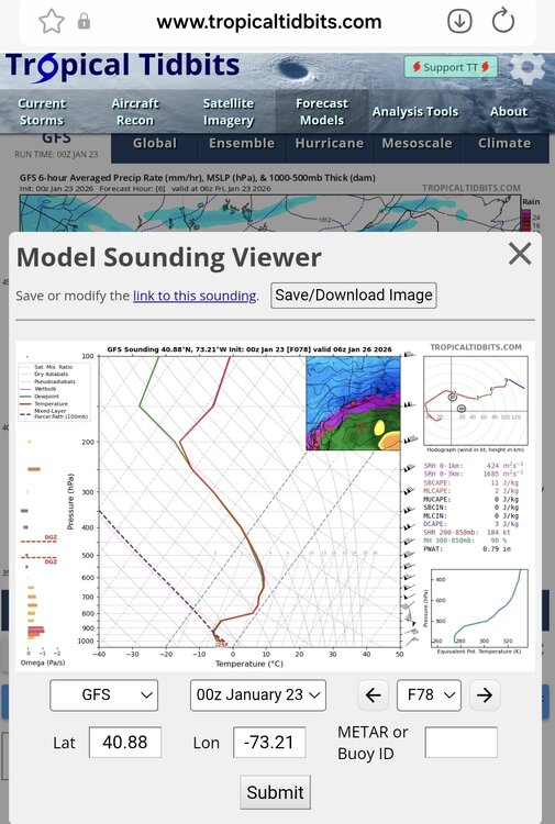
-
Extreme Cold, Snow & Sleet: SECS 1/24 - 1/26
NorthShoreWx replied to TriPol's topic in New York City Metro
He's a good man. -
Extreme Cold, Snow & Sleet: SECS 1/24 - 1/26
NorthShoreWx replied to TriPol's topic in New York City Metro
So is 20" of snow with an inch and a half of water content. Which is heavier, a pound of feathers or a pound of rocks? -
Umm, has anyone seen Franklin?
-
Roger Smith for President!
-
Extreme Cold, Snow & Sleet: SECS 1/24 - 1/26
NorthShoreWx replied to TriPol's topic in New York City Metro
Nexactly! -
Extreme Cold, Snow & Sleet: SECS 1/24 - 1/26
NorthShoreWx replied to TriPol's topic in New York City Metro
There hasn't been plenty of anything over the past 5 years. -
Extreme Cold, Snow & Sleet: SECS 1/24 - 1/26
NorthShoreWx replied to TriPol's topic in New York City Metro
540 line is too rough to use as a definitive ptype demarc especially when it is still close. 546, which is depicted to our south could still be snow. The devil is in the details. The 850s do look very warm at 96 and beyond. -
Extreme Cold, Snow & Sleet: SECS 1/24 - 1/26
NorthShoreWx replied to TriPol's topic in New York City Metro
Then you would have loved the blizzard this week in 1978: https://www.northshorewx.com/19780120.html -
Extreme Cold, Snow & Sleet: SECS 1/24 - 1/26
NorthShoreWx replied to TriPol's topic in New York City Metro
Yeah, all this pure snow we've been getting the past 3 or 4 winters is getting boring -
Extreme Cold, Snow & Sleet: SECS 1/24 - 1/26
NorthShoreWx replied to TriPol's topic in New York City Metro
GFS LP drops 22mb in 24 hours. Only a wee bit shy of a bomb, and with that big high over Quebec, there would be some wind. -
Extreme Cold, Snow & Sleet: SECS 1/24 - 1/26
NorthShoreWx replied to TriPol's topic in New York City Metro
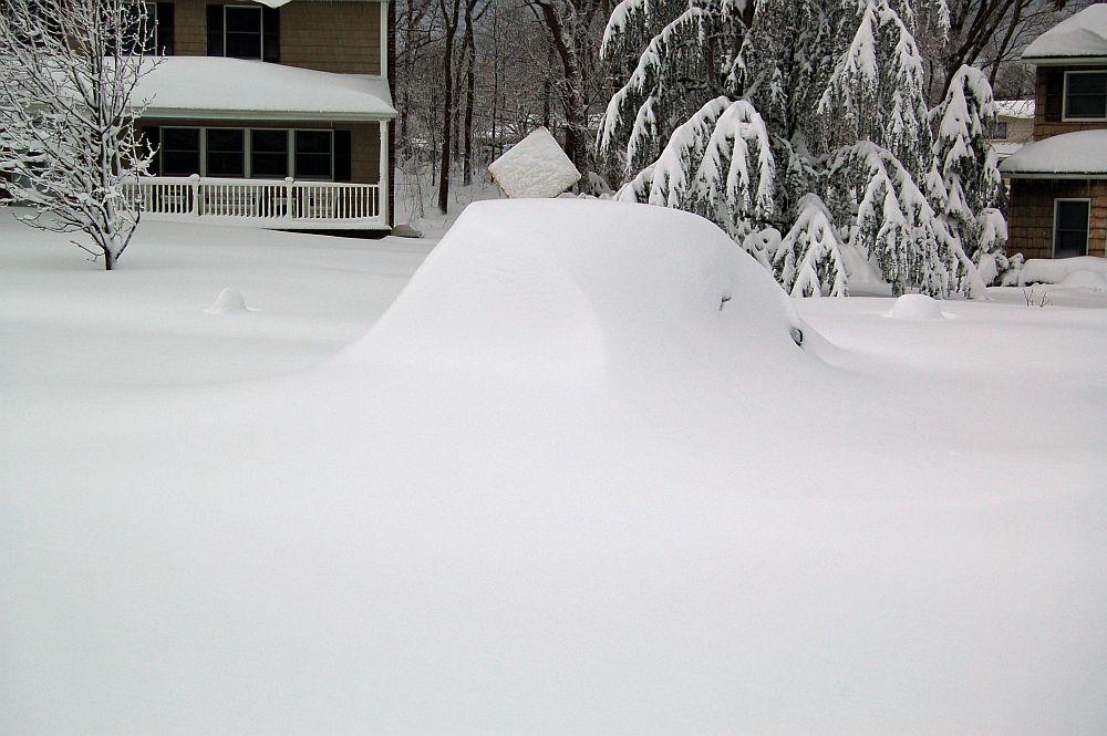
Awesome photo! Similar scene here: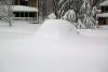
-
Extreme Cold, Snow & Sleet: SECS 1/24 - 1/26
NorthShoreWx replied to TriPol's topic in New York City Metro
I basically agree, except that I was here in 1978. -
Extreme Cold, Snow & Sleet: SECS 1/24 - 1/26
NorthShoreWx replied to TriPol's topic in New York City Metro
That was all snow here with an excruciatingly long period of rain on the south shore. -
Extreme Cold, Snow & Sleet: SECS 1/24 - 1/26
NorthShoreWx replied to TriPol's topic in New York City Metro
And this is a problem why? -
Temperature got up to 34 briefly during the day before falling back below freezing, but it's been warming since sunset and is now up to 37.6 with snow flurries.
-
Extreme Cold, Snow & Sleet: SECS 1/24 - 1/26
NorthShoreWx replied to TriPol's topic in New York City Metro
Seems you've answered your own question. -
Extreme Cold, Snow & Sleet: SECS 1/24 - 1/26
NorthShoreWx replied to TriPol's topic in New York City Metro
It doesn't even flip on LI (at least on those Pivotal p-type maps). Rare but not unheard of. Reminds me of 2-13-14 when we never got above freezing and were getting freezing rain while other places, including some inland, were getting plain rain.