

NorthShoreWx
-
Posts
5,510 -
Joined
-
Last visited
Content Type
Profiles
Blogs
Forums
American Weather
Media Demo
Store
Gallery
Everything posted by NorthShoreWx
-
Storm potential January 17th-18th
NorthShoreWx replied to WeatherGeek2025's topic in New York City Metro
You are overestimating the warm. -
Storm potential January 17th-18th
NorthShoreWx replied to WeatherGeek2025's topic in New York City Metro
It's snowing lightly here, but you'd think it was much heavier based on the visibility. Very cool vibe with the light snow and fog and everything plastered with snow. 32.7⁰, Today's snowfall so far 1.1". NWS forecast looks good, but there could be a little extra excitement this evening as the column cools a little more. -
Storm potential January 17th-18th
NorthShoreWx replied to WeatherGeek2025's topic in New York City Metro
Gotta like Uncle Joe's! -
Storm potential January 17th-18th
NorthShoreWx replied to WeatherGeek2025's topic in New York City Metro
That's a good trade-off, even with the snow. As the owl says, "divertiti"! -
Storm potential January 17th-18th
NorthShoreWx replied to WeatherGeek2025's topic in New York City Metro
@weathafellais still posting here. Check the SNE forum. https://www.americanwx.com/bb/profile/79-weathafella/ So is Randy: https://www.americanwx.com/bb/profile/9-stormtracker/ -
0.3" Smithtown
-
Storm potential January 17th-18th
NorthShoreWx replied to WeatherGeek2025's topic in New York City Metro
Snow getting lighter. Down to a dry heave. 33⁰ New snow accumulation since last report - 0.3" Snow depth - T -
Storm potential January 17th-18th
NorthShoreWx replied to WeatherGeek2025's topic in New York City Metro
It's projectile vomiting snow. Temp 35⁰ New snow accumulation since last report - T Snow depth - 0.0" -
Storm potential January 17th-18th
NorthShoreWx replied to WeatherGeek2025's topic in New York City Metro
Just started flurrying here. Temp down but still warm at 40⁰ -
Storm potential January 17th-18th
NorthShoreWx replied to WeatherGeek2025's topic in New York City Metro
Nice day here. 42⁰ It looked for a while like the sun might peak through the clouds. -
Storm potential January 17th-18th
NorthShoreWx replied to WeatherGeek2025's topic in New York City Metro
Stay away from the forum for a few weeks and you will be completely ignoring them. -
They're all useful. They are just tools falling into the wrong hands.
-
Storm potential January 17th-18th
NorthShoreWx replied to WeatherGeek2025's topic in New York City Metro
That's a pretty good synopsis of this thread, minus the mania. -
It's getting near 5 posting time. 50% of the posts in the so-called storm thread are from 2 posters who have nothing to say. Please excuse my candor.
-
-
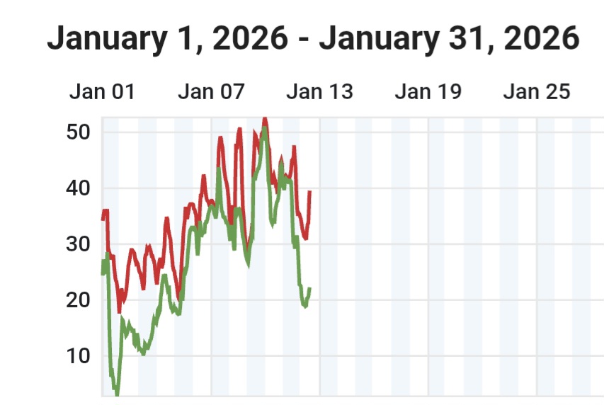
Not the park, but central LI in some January's with "poor starts" (note that the 1.3" on 1/31 /21 was the start of a 17" snowfall):: J A N J A N J A N J A N Day 2005 2015 2016 2021 1 0.0 0.0 0.0 T 2 0.0 0.0 0.0 0.0 3 0.0 T 0.0 T 4 0.0 0.0 T T 5 0.2 0.0 T 0.0 6 0.1 0.5 0.0 0.0 7 0.0 T 0.0 0.0 8 T 0.0 0.0 0.0 9 0.0 1.7 0.0 0.0 10 0.0 0.0 0.0 0.0 11 0.2 0.0 0.0 0.0 12 0.0 0.0 T 0.0 13 0.0 0.0 0.0 0.0 14 T T T 0.0 15 0.0 0.0 0.0 0.0 16 0.1 0.0 0.0 0.0 17 2.5 0.0 0.9 0.0 18 0.0 0.0 T 0.0 19 3.1 0.0 0.0 0.0 20 0.1 0.0 0.0 0.2 21 0.0 T 0.0 0.0 22 11.4 T T 0.0 23 3.0 0.0 17.0 0.0 24 T 4.0 0.5 0.0 25 0.0 0.0 0.0 0.0 26 1.0 5.0 0.0 0.3 27 0.1 10.0 0.0 T 28 0.0 T T 0.0 29 0.0 0.0 0.0 0.0 30 0.1 0.8 0.0 0.0 31 0.0 0.0 0.0 1.3 Total thru 1/15 0.5 2.2 0.0 0.0 Total for January 21.9 22.0 18.4 1.8 Max Daily 11.4 10.0 17.0 1.3 Footnote: Snowfall here this month through January 12 is 1.1" (ahead of 2005, 2016, and 2021). I think that the big snowstorms spawned those months were all Miller B's, even 2016.
-
I'm not sure how long it lasts, but it is more typically towards the end of the month. I've always felt it is one of those things that you can subjectively fit into any January... there's always going to be a few days warmer than all of the others.
-
This reads more like a "normal up", although there were those 50⁰ maxes 1/8-10. IMBY:
-
Do you feel better now?
-
Nice snow squall here
-
A trained spotter ought to know the difference.
-
Mmmmm, perdy. Lock it in.
-
Is this how you met: "Read any good skew-T's lately"?
-
Are you a bot?
-
I kind of get the rationale for -3C being a threshold proxy for enduring winter snow cover, but what is behind the 64.4 for tropical? (apologies that we are mixing °C and °F)


