-
Posts
18,122 -
Joined
-
Last visited
Content Type
Profiles
Blogs
Forums
American Weather
Media Demo
Store
Gallery
Everything posted by michsnowfreak
-
What was your peak depth? Detroit peaked at 9" Jan 26-29 and Feb 7.
-
Exactly. I remember feb 2015 so vividly because first we had the 16.7" snowstorm then the insane cold. My grandpa was near the end of his life so we went to celebrate his feb 19th birthday despite wind chill warnings to not go out, much less for elderly. But other than being a historic month, it caused no lasting harm. The two week march inferno in 2012 literally ruined the entire 2012 growing season for fruit growers.
-
Agree. When you talk march 2012 you aren't talking mild, when you talk feb 2015 you aren't talking cold. Youre talking historic on a local level. And theres no sign of that here. For the SW its even worse because they are getting their march 2012 now,.but they already average way warmer.
-
Not even close for the Great Lakes and northeast. The west is a different story.
-
If this storm was aligned in the Chicago to Detroit corridor it would be a massive thread. This is the equivalent of a new England threat where the northern half of Maine is the southern extent of the goods.
-
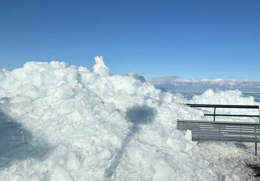
I head there for a 3-4 day trip every mid to late feb. This year we had a good cold, white winter here in southern MI, but once deep winters back gets broken in southern MI, northern MI hits peak. Their deepest snow is usually mid Feb to mid Mar. Its incredible. I seriously thought about heading up for the storm but its extra cash I shouldn't spend and I risk getting stuck in the UP for an unknown amt of time with Mackinac Bridge closures. For reference. The area thats expecting 12-36" of snow over a 48 hour period....thats on top of a massive snowpack. This pic was from Feb 18.
-
DTW gusted to 71 mph today.
-

Winter 2025-26 Medium/Long Range Discussion
michsnowfreak replied to michsnowfreak's topic in Lakes/Ohio Valley
It seems like November is the better winter month than March lately. -
I told a local weather friend last month that we are due for some quick melting snows late winter/spring to beef our total up. I said its only fair because we had such extensive snowcover during the winter but snowfall is near avg. Unfortunately mother nature may take that literally, as we have 2 chances of snow (fri morning and sun morning) that would melt as soon as they are done falling. At least as the models portray it now.
-
Yup. I didnt go to the doctor, i did a telehealth for an antibiotic, but my mom went and said her dr wore a mask and usually doesn't. Its all over.
-
Totally random, but sooo many people (myself included) have sinus infections. My moms doctor actually said she thinks one of the factors is bacteria released in the air when the snow melted started a big wave of those infections. Speaking of snow, the fact that a near-winterlong snowblanket protected the ground from much frost damage will combine with the heavy rain this past week to help the grass greenup quickly. You can already see some green emerging.
-

2025-2026 ENSO
michsnowfreak replied to 40/70 Benchmark's topic in Weather Forecasting and Discussion
Good winter here in southeast MI. Couldve used a bigger storm, but solid cold and snowcover paired with frequent snowfall from late November thru mid Feb made it quite enjoyable for the winter enthusiast. Snow has always been a big part of the economy for northern MI and im sure northern New England too. What happened this winter out west sucks. My brother has heard it firsthand from friends in Denver. But its not like any of us control the weather. If i could wave a magic wand and bury the west i would. But im not going to feel guilty that it was a good winter in the lakes and northeast. Hopefully next year is better for you guys. -

2025-2026 ENSO
michsnowfreak replied to 40/70 Benchmark's topic in Weather Forecasting and Discussion
The warmth yesterday and today was very impressive here (70s) as will be the cold early next week. Beyond that, I expect pretty mundane spring weather here in the Lakes for a while. Not warm and not cold. -
Ill probably go B+ but I dont like grading before April. Im sitting at 39.8" of snow, so snowfall itself very average overall. A hot start but a shitty February and so far a non-existent March. However despite very mundane weather since mid-February, that does not take away the fact that the winter featured well below avg temps and well above avg snowcover. A huge majority of Decemer to mid-February featured a thick glittery blanket of snow, constant flakes, and crisp cold winter air. The "early exit" sucks, but doesnt take away the early arrival either. Cant recall a winter when deep winter set in so early. We had just two brief meltoffs between Thanksgiving & mid-Feb (Christmas & 2nd week of Jan), surprised you melted in early Dec.
-
Who uses "ever" when referencing weather stats? I know it absolutely drives you insane that so much of the region saw above avg snowfall in the 2000s-10s. Ohio was clearly an anamoly in the well above avg snow that dominated MI/WI for many winters (particularly 2005-2015) but the trend of up then down the past 20 years is the same at Cleveland and toledo as the rest. TOL- past 10 years, 24.2", previous 10 years- 42.9" CLE- past 10 years 38.0", previous 10 years- 65.6"
-
I was just at meijer. The snow piles in the parking lot are gone. They were massive when I was there like 10 days ago.
-

2026-2027 El Nino
michsnowfreak replied to Stormchaserchuck1's topic in Weather Forecasting and Discussion
We won't know the reality for months, but i would be SHOCKED if the 2026-27 el nino is strong. You just dont get strong events like that 3 years apart. -

2025-2026 ENSO
michsnowfreak replied to 40/70 Benchmark's topic in Weather Forecasting and Discussion
Once again. I have no doubt warmth will eventually spread further north and east. Especially as our snow is gone, ice is breaking up on the lakes and the ground is thawing. But none of the ensembles show massive warmth engulfing the lakes into new England right after March 20th. -

2026-2027 El Nino
michsnowfreak replied to Stormchaserchuck1's topic in Weather Forecasting and Discussion
Sorry. Back to '26-27 -

2026-2027 El Nino
michsnowfreak replied to Stormchaserchuck1's topic in Weather Forecasting and Discussion
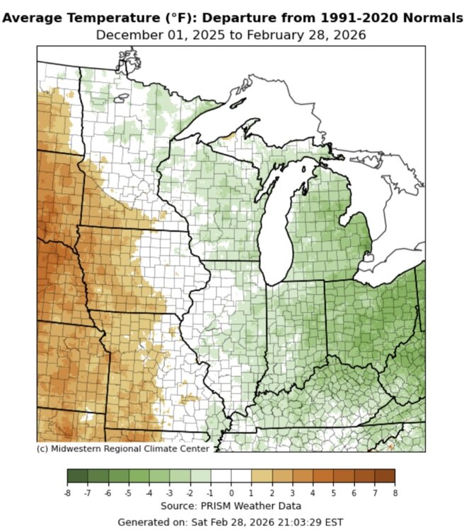
His point about cold winning out from the western warmth the further east you went is very apparent from the winter temp departure. -

2026-2027 El Nino
michsnowfreak replied to Stormchaserchuck1's topic in Weather Forecasting and Discussion
Yes its torching today. I wasnt referring to you, I was referencing the fact that as soon as winter got off to a cold start, some were "projecting" a warm jan, then a warm feb. Like you, I primarily care about the weather where I live (SE MI) so the frequent posts about record warmth in the West were an afterthought in our cold, white winter. This winter was unusually in that Detroit averaged quite a bit colder than Chicago, but it made sense in this pattern as Chicago was further west. It was still a colder than avg winter at ORD, but very front loaded. -
-

2026-2027 El Nino
michsnowfreak replied to Stormchaserchuck1's topic in Weather Forecasting and Discussion
Not sure. It does seem like the wishcasting warmth for the east this winter has been no different than previous years when some wish casted cold. Its usually short-lived or fails. Obviously theres a warmer signal after the cold (which does not seem confined to just Mar 16-19) but ill remain very skeptical of a torch here until it is imminent. Haven't finished above avg at Detroit since Oct. Nov: -0.4° Dec: -3.6° Jan: -5.2° Feb: -0.2° -

Winter 2025-26 Medium/Long Range Discussion
michsnowfreak replied to michsnowfreak's topic in Lakes/Ohio Valley
AI Euro has done decent this winter. But get ready for plenty of model waffling this week. -

2026-2027 El Nino
michsnowfreak replied to Stormchaserchuck1's topic in Weather Forecasting and Discussion
The warmth has been crazy all winter out West. Glad its not here though. Detroit hasn't had a warmer than avg month since October.


