

michsnowfreak
-
Posts
15,700 -
Joined
-
Last visited
Content Type
Profiles
Blogs
Forums
American Weather
Media Demo
Store
Gallery
Posts posted by michsnowfreak
-
-
3 hours ago, Snowstorms said:
How much snow did Detroit receive in Dec 1877? Dec 1877 is the least snowiest ever on record here with only 0.3". Dec 1877 is the 7th warmest on record here. 2015 and 2023 take the cake for top 2 though.
1889-90 was the warmest of the 4 winters you mentioned with a mean DJF temperature of 30.3F in Toronto. I haven't looked at the warmest/coldest winters in Toronto yet. I only have for YYZ (going back to 1938). The 30.3F would make 1889-90 the 4th warmest on record, behind 01-02, 11-12, and 15-16, respectively, since 1938.
However, temperature records, especially over the last 30-40 years would definitely be impacted by UHI and urbanization, especially overnight lows. I don't know how applicable this principle would be for Detroit, but most major weather stations are either in the city or at the airport which can cause a "heat island" effect. Not trying to discredit climate change here though.
But seeing how warm some of those 1800 winters were that you mentioned, in a time where there was no "industrial revolution" or "UHI" is pretty impressive.
Dec 1877 had 1.9" snow but 1.6" of it fell on Dec 1st. The other 0.3" fell on the 6th. Funny thing about 1877...it had two unusually snowless winter months. In Feb 1877, only 0.04" precip (driest Feb on record) and 0.2" snow fell. Unlike the mild winter of 1877-78, however, the winter of 1876-77 was very cold in Dec/Jan then a crazy swing to torch in Feb.
Its no surprise that acknowledging warm winters that occurred in the old days does NOT sit well with TCC, and he has posted 1800s coop data to discount the official data, where often times a coop was usually a farmer that would record temps 2 or 3 times a day, as most didnt have a max/min thermometer. Coop data is full of errors today, I can only imagine its accuracy 140 years ago
 . I guess the golden rule is use all cold/snowy data from the old days but discount the warm/snowless
  . No one here denies a gradual climate warming overtime, but the stretches he takes to discount any old warm winters/hot summers, or downplay any current cold snaps, cold/snowy stretches is really over the top.
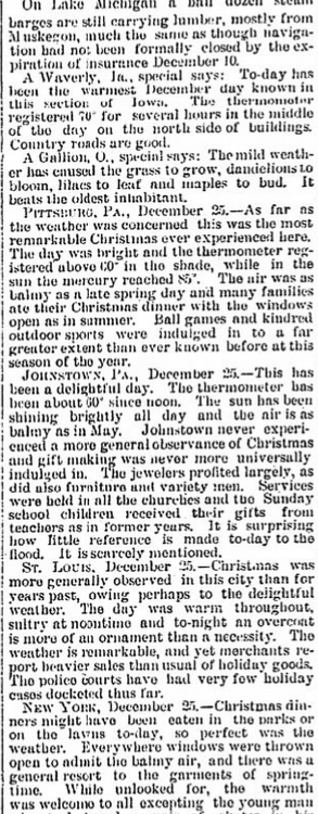
There is PLENTY of documentation about the warm winters of 1877-78, 1879-80, 1881-82, 1889-90. And locally, 1881-82 & 1889-90 were extraordinarily free of snow. I have attached an article from the December 26, 1889 Detroit Free Press discussing the weather, but also take a look at the rankings of those 4 winters. They all rank very high on everyones list.
Rankings of those winters in terms of warmest:
DETROIT (since 1870)
1.) 1881-82
3.) 1889-90
11.) 1879-80
15.) 1877-78
TOLEDO (since 1873)
1.) 1889-90
2.) 1879-80
4.) 1881-82
7.) 1877-78
CLEVELAND (since 1870)2.) 1889-90
6.) 1879-80
14.) 1877-78
17.) 1881-82
CHICAGO (since 1872)
1.) 1877-78
3.) 1879-80
4.) 1881-82
5.) 1889-90
LANSING (since 1863)
1.) 1889-90
7.) 1879-80
12.) 1881-82
15.) 1877-78
INDIANAPOLIS (since 1871)
1.) 1889-90
3.) 1879-80
4.) 1877-78
6.) 1881-82

-
 1
1
-
 1
1
-
-
13 minutes ago, Lightning said:
Yeah that SB storm was only heavy in the hills of Oakland but most place 2-5" I lived near Alpine Valley and parts of Oakland had a bit over 6". After an incredible Dec start to winter that SB storm ended up being my biggest storm of that winter.
Oh I remember that 2015 storm being near a foot+ all over. I was happy knowing you finally got your big one. That February was awesome!!
Its actually incredible to think that we had two Februaries in a row (2014 & 2015) with wall to wall double digit inch snow depth here.
-
1
-
-
41 minutes ago, Lightning said:
It was SB day. Got several up this way with the SB2006 but most places only got a couple/few inches.
Super Bowl 2006 dropped 3.6 inches here, but just 2 inches at DTW. Several days in advance much heavier snow is forecast.
2015 on the other hand, as posted above, was awesome. It was probably the most widespread storm to drop more than a foot of snow over all of Southeast Michigan in decades (jackpot was this area).
-
1 hour ago, Stevo6899 said:
For some odd reason I don't recall this storm here in metro detroit. Maybe it was ghd2? I do remember a snowstorm forecasted 3-5 days before detroit hosted the superbowl in 2006. I don't think anything even ended up accumulating.
If you truly don't recall GHDII, Feb 1-2, 2015, SMH lol. It was a fantastic storm and the 16.7" of snow at DTW made it the largest storm since 1974. It's my favorite storm.
It's easy to get lost in the shadow of the 2013-14 winter, but the 2015 storm was incredible.


-
2
-
-
Definite zzzs to start the month. Snow has melted but the ground undoubtedly use some drying out. Pattern change towards Valentines, 2nd half of the month gonna be rockin'
-
As said, it was the wettest January on record for Detroit, pretty much unheard of for a strong Nino.
01.) 5.25” – 2024
02.) 5.02” – 1932
03.) 4.96” – 1874
04.) 4.38” – 1950
05.) 4.31” – 1916The 17.0" of snowfall didnt make the top 20 (this ranks as 27th snowiest), but definitely a win considering the nationwide pattern.
Skycover averaged 9.1/10, a powerball-special cloudy month. This is reflected in temps as well. The mean temp of 27.5F is +1.7F, but the breakdown was high 32.2F (-0.1F) and low 22.8F (+3.6F). The spread of max/min was 44F/-3F.
PRELIMINARY LOCAL CLIMATOLOGICAL DATA (WS FORM: F-6) STATION: DETROIT MI MONTH: JANUARY YEAR: 2024 LATITUDE: 42 13 N LONGITUDE: 83 20 W TEMPERATURE IN F: :PCPN: SNOW: WIND :SUNSHINE: SKY :PK WND ================================================================================ 1 2 3 4 5 6A 6B 7 8 9 10 11 12 13 14 15 16 17 18 12Z AVG MX 2MIN DY MAX MIN AVG DEP HDD CDD WTR SNW DPTH SPD SPD DIR MIN PSBL S-S WX SPD DR ================================================================================ 1 36 31 34 6 31 0 T T 0 9.2 18 20 M M 10 1 27 20 2 33 30 32 5 33 0 0.00 0.0 0 14.0 22 260 M M 10 28 260 3 35 32 34 7 31 0 0.04 0.2 0 8.9 17 360 M M 10 16 24 350 4 32 19 26 -1 39 0 T T T 8.0 18 360 M M 7 25 350 5 32 19 26 -1 39 0 0.00 0.0 0 6.1 14 210 M M 9 17 200 6 37 28 33 6 32 0 0.03 0.2 0 6.9 13 70 M M 10 1 19 70 7 36 30 33 7 32 0 0.06 0.6 T 5.6 13 290 M M 10 1 18 290 8 36 32 34 8 31 0 0.00 0.0 0 7.3 13 160 M M 10 18 18 170 9 44 33 39 13 26 0 0.86 T 0 12.1 33 230 M M 10 1 43 230 10 40 33 37 11 28 0 0.01 T T 16.1 31 240 M M 10 1 41 240 11 37 31 34 8 31 0 0.09 1.5 1 10.3 21 230 M M 10 18 26 240 12 38 30 34 8 31 0 1.04 4.6 0 11.2 29 220 M M 10 128 37 240 13 37 17 27 1 38 0 0.04 0.9 3 24.3 38 230 M M 10 19 52 230 14 17 -2 8 -18 57 0 0.02 0.6 4 20.8 30 240 M M 7 89 39 240 15 9 -3 3 -23 62 0 0.00 0.0 4 12.4 17 230 M M 6 22 230 16 12 3 8 -17 57 0 0.03 0.6 4 14.7 22 240 M M 7 1 28 230 17 18 2 10 -15 55 0 T T 4 17.0 28 230 M M 7 35 230 18 25 18 22 -3 43 0 0.12 2.5 5 8.2 15 220 M M 10 1 20 230 19 23 8 16 -9 49 0 0.11 2.0 6 8.8 21 10 M M 8 19 28 10 20 19 2 11 -14 54 0 T T 7 8.7 22 320 M M 5 29 330 21 25 7 16 -9 49 0 0.01 0.1 6 9.1 22 220 M M 6 27 230 22 33 9 21 -4 44 0 0.05 T 6 11.6 21 220 M M 9 146 26 230 23 34 32 33 8 32 0 0.45 T 5 3.9 9 150 M M 10 126 14 120 24 39 33 36 11 29 0 0.35 0.0 4 1.8 9 40 M M 10 12 11 40 25 40 36 38 13 27 0 0.17 0.0 2 5.8 14 50 M M 10 12 21 40 26 41 32 37 12 28 0 1.07 0.0 T 4.9 16 30 M M 10 12 25 30 27 41 35 38 13 27 0 0.01 0.0 T 4.6 13 40 M M 10 18 18 50 28 39 33 36 11 29 0 0.41 0.8 0 12.4 22 20 M M 10 1 32 20 29 37 32 35 10 30 0 T T 0 8.6 20 200 M M 10 23 200 30 34 31 33 8 32 0 0.28 2.4 0 7.3 17 200 M M 10 12 24 220 31 39 33 36 11 29 0 0.00 0.0 2 8.4 23 230 M M 10 1 30 240 ================================================================================ SM 998 706 1155 0 5.25 17.0 309.0 M 281 ================================================================================ AV 32.2 22.8 10.0 FASTST M M 9 MAX(MPH) MISC ----> 38 230 52 230 ================================================================================ NOTES: # LAST OF SEVERAL OCCURRENCES COLUMN 17 PEAK WIND IN M.P.H. PRELIMINARY LOCAL CLIMATOLOGICAL DATA (WS FORM: F-6) , PAGE 2 STATION: DETROIT MI MONTH: JANUARY YEAR: 2024 LATITUDE: 42 13 N LONGITUDE: 83 20 W [TEMPERATURE DATA] [PRECIPITATION DATA] SYMBOLS USED IN COLUMN 16 AVERAGE MONTHLY: 27.5 TOTAL FOR MONTH: 5.25 1 = FOG OR MIST DPTR FM NORMAL: 1.7 DPTR FM NORMAL: 3.02 2 = FOG REDUCING VISIBILITY HIGHEST: 44 ON 9 GRTST 24HR 1.24 ON 25-26 TO 1/4 MILE OR LESS LOWEST: -3 ON 15 3 = THUNDER SNOW, ICE PELLETS, HAIL 4 = ICE PELLETS TOTAL MONTH: 17.0 INCHES 5 = HAIL GRTST 24HR 4.6 ON 12-12 6 = FREEZING RAIN OR DRIZZLE GRTST DEPTH: 7 ON 20 7 = DUSTSTORM OR SANDSTORM: -
13 minutes ago, RogueWaves said:
I guess now that I left Canton, it decided to snow there again. Ofc
When did you move? Was a solid snow month in DTW all things considered.
-
1
-
-
6 minutes ago, TheClimateChanger said:
Interesting. At least in January & February 1878, it looks like it was a pretty solid winter for Detroit. Nearly 15" of snow on today's date in 1878.
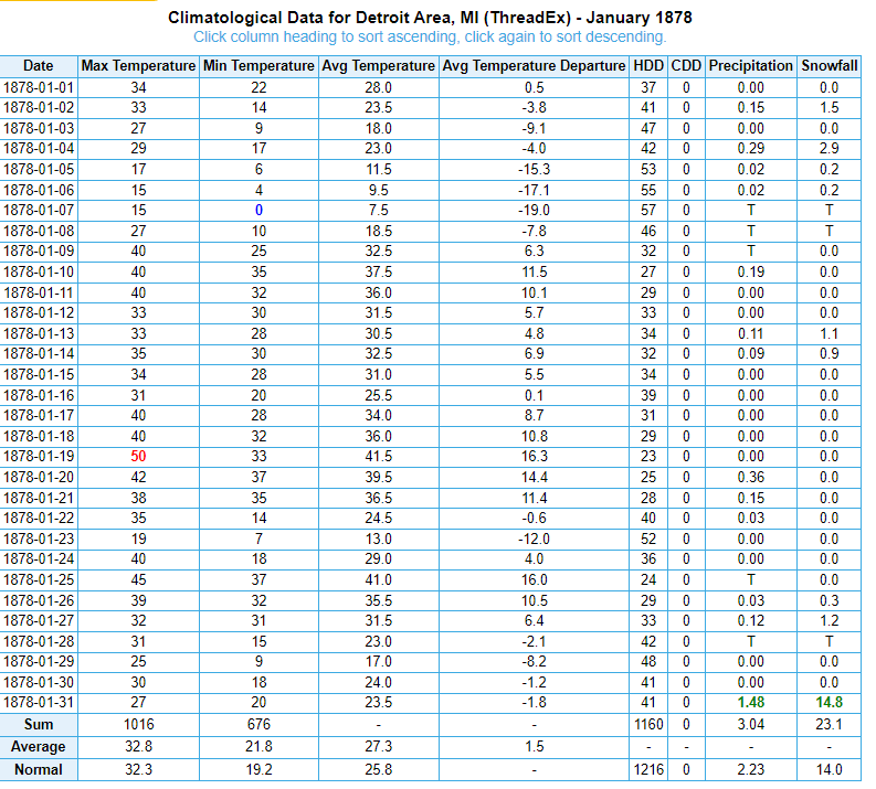
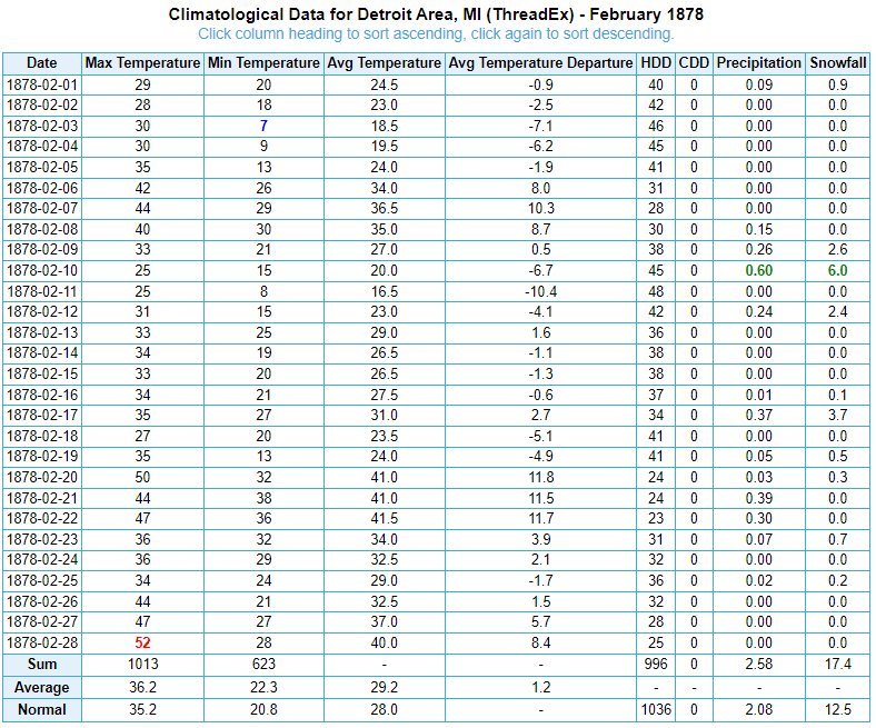
Yes. I always get frustrated that there's a little bit of missing data in the 1870s, because due to that, DTX does not start official snowfall data until 1880. I understand the need for consistency, but there were several good snow storms in the 1870s and also a few snowy AND snow futility records that I feel should be added to the mix.
-
1 hour ago, TheClimateChanger said:
Detroit has been a snow magnet this winter. Somehow you guys have only had 2" less than Erie (which averages 104.3" annually) on the season-to-date, on the downwind side of Lake Erie.
It's been very active. I'm in a chat with some local weather guys, and January snowfall has ranged from 15.3" in Monroe to 24.4" in Lake Orion (elevation helped in a few slop events). Most of the immediate metro has had 15-20". While there were several powder events during the cold snap, there have also been several snowfalls with very low ratio snow. In the end, I'd estimate about half of the 5.25" has fallen as actual snow.
-
42 minutes ago, TheClimateChanger said:
Still a far cry from needing to mow the lawn. I see dandelions after every warm spell in recent winters in Ohio and Pennsylvania. Here’s one from December:

I'm not saying you're wrong. I just posted what was in the newspaper at the time.
-
1 hour ago, Snowstorms said:
Damn. Seems like the warmth has been centered around Minnesota and further NW this month. Our warmest high this month was 43. Last time we hit 50 was Dec 15. Nonetheless were going to finish January 7 degrees above average lol.
Im wondering if this is similar to 1877-78, where the core of the warmth was centered in MN/the Plains? While it was certainly a mild winter here in 1877-78, it wasnt nearly the magnitude of out there. To date, 1877-78 stands as Detroits 16th warmest winter on record. Other winters of that era of up-and-down winters that rank higher on Detroits warmest list are 1881-82, 1879-80, and 1889-90. The warmth and lack of snow in 1881-82 & 1889-90 is FAR more impressive here than the mild winter of 1877-78 which actually saw slightly above avg snowfall. While December 1877 is Detroits 5th warmest on record, January and February 1878 dont even make the top 20. Meanwhile, there is tons of documentation and stories about how wild Minnesota's Year Without a Winter was in 1877-78, and it appeared even worse in Duluth than Minneapolis. (Duluth was warmer than Detroit in Feb 1878!)
And same here. The warmest temp this January at DTW is 44F. Only 29 years of the 151 years on record saw a lower max temp in January.
-
1 hour ago, TheClimateChanger said:
Nonsense, probably already high grass. This December was 3.4F warmer than January 1932 in Detroit - were you mowing the lawn on Christmas?
While that very well may be the case (high grass), there was documentation of dandelions in bloom throughout lower MI in January. This years warm December was following an average November which ended with a cold snap, and was followed by a big cold snap in January. At the time of that picture (mid-Jan 1932), there had been almost no cold to speak of that winter. To this day, Nov 1931 stands as the warmest on record, Dec 1931 the 9th warmest, and Jan 1932 the warmest. There was also a lot of rain the entire time.
-
It has turned into another London night with fog and slowly melting snow here.
-
1
-
-
26 minutes ago, Stevo6899 said:
Crazy how detroit broke the precip record for january after today. Who would've thought half of it was probably liquid.
1 minute ago, Stebo said:1932 January had .9" so it was almost all rain. Imagine having that happen
You beat me to it. lol.
1932 was also the warmest January on record. This, combined with constant rain, had dandelions in bloom throughout Jan in MI.
Looking at the top 10 wettest Januarys, wet doesnt always mean snowy.
01.) 5.25” – 2024 (snow 17.0”)
02.) 5.02” – 1932 (snow 0.9”)
03.) 4.96” – 1874 (snow 17.9”)
04.) 4.38” – 1950 (snow 9.5”)
05.) 4.31” – 1916 (snow 1.1”)
06.) 4.27” – 1929 (snow 22.1”)
07.) 4.12” – 2020 (snow 9.7”)
08.) 3.95” – 1913 (snow 8.0”)
09.) 3.92” – 1993 (snow 11.0”)
10.) 3.87” – 1907 (snow 12.7”)
This picture was published in the January 16, 1932 Detroit Free Press. A woman posed with grass clippings after mowing her grass.

-
2
-
-
2 minutes ago, mississaugasnow said:
we've had 6 days but tons of days just a trace
I'll post the f6 after tmrw. Definitely trace days here too, comes with the climo
-
1
-
-
7 minutes ago, mississaugasnow said:
wow, you guys have been cashing in down there. Toronto will finish with around 11" which is pretty much normal for January.
Its been nonstop. We have had a grand total of 4 days in January with 0 precip.
-
DTW reported 2.4" snowfall on 0.28" liquid today.
It's officially Detroit's wettest January on record at 5.25", breaking the previous 1932 record of 5.02".
Snowfall for the month, while not a record, was also above average. At 17.0" this ranks is the 27th snowiest January on record. The snowiest January was set 10 years ago (39.4") during the unforgettable 2013-14 winter. Season to date snowfall at DTW is 19.5".
I saw 1.8" today, bringing my monthly total to 16.0" and the season to 18.1".
-
2
-
-
2 hours ago, AWMT30 said:
Well closing with 5.3" of snow here in Canton, Michigan. VERY VERY VERY PLEASED
congrats.
2 hours ago, Stevo6899 said:I'd imagine areas along 59 were the jackpot. Funny possibly the biggest event of the winter might be one where 1-2 were forecasted. Did the band just stall out. What did the models miss?
Seems like extreme northern Wayne/Washtenaw into much of Oakland/Livingston/Macomb was the jackpot with 4-5.5". But obviously the biggest storm of the season so far was Jan 12th.
We missed the band early on which got those areas off the ground running, so we finished with 1.8" imby, more inline with the actual forecast lol. Since mild weather is coming, im not nearly as mad as I would be if it was going to be cold.
-
Snowing beautifully out. Missed the heavy band that creamed areas north and west of me though. Crazy to think some will end up with 4 or 5" out of this. Stings a bit less knowing mild weather is immediately on its heals.
In any event, with moderate snow falling at the 11am obs, DTW has officially seen the wettest January on record. Stats later.
Friend who does salting/plowing (not sure if he posts here sometimes?) said he has had 29 billables this season (dont know what that means lol) and 25 have been in January.
Been a very, very active month in southeast MI, both good and bad.
-
9 hours ago, Great Snow 1717 said:
This winter has been a lot like the Lions were yesterday...it just fails to produce when it matters.Instead of a lion it has been

Detroit's low temperature this winter has been -3° so far, but the lions showed Detroit a whole different type of cold yesterday after halftime

-
 1
1
-
-
23 hours ago, cyclone77 said:
Looking forward to seeing sunshine tomorrow after a full week of dark gloom.
Full week? Amateur!
signed, Michigan.
-
1
-
 2
2
-
-
1 hour ago, OrdIowPitMsp said:
Warmest winter on record is gonna be locked up by mid month for mby. Might as well make it the least snowy as well and hit the futility daily double.
That's crazy. Minneapolis' infamous 1877-78 may move to 2nd place.
-
2 hours ago, Build Back Better Winters said:
Wasn’t that way this summer either, DTW was consistently cooler than DET this summer, I do think @TheClimateChangerhas a point.
With that being said, it looks directly on point with nearby unofficial temps right now. Certainly doesn’t stand out like this:

DET is not a first order station so it's not monitored/calibrated, plus it is quite a ways from DTW. Depending on the airmass and flow, sometimes DET will be warmer and sometimes not. Regardless the whole assertion that DTW runs cold is utterly ridiculous. It's either tcc trolling or more grasping for warm straws that aren't there, simply because I asked a legitimate question about Milwaukee. DTW is still among the warmer temperatures every day on the DTX RTP round up.
-
Fantastic analysis as always @OHweather.
I never DONT want snow in winter, but since reality has been for a while that the first half of Feb will mostly suck, Im actually not mad about getting some zzz's. After tomorrows burst of snow it looks to dry out for a while after what will be our wettest January on record (snowfall above avg too, but not top 20 territory).
By about Feb 10th, I hope to be feasting on some model eye candy and would love to do a repeat of what we saw from Jan 11-24 or so.
-
3
-


January 2024 General Discussion
in Lakes/Ohio Valley
Posted
LOL. 1889-90 is probably the warmest winter this region as a whole has seen, but lets discount it. BTW, KYIP ran warmer than DTW when there was a temp sensor issue, which has been fixed.