

michsnowfreak
-
Posts
17,088 -
Joined
-
Last visited
Content Type
Profiles
Blogs
Forums
American Weather
Media Demo
Store
Gallery
Posts posted by michsnowfreak
-
-
12 hours ago, OrdIowPitMsp said:
Average to date here is 41.3” so still -15.7” on the season but this made a huge dent and the long range holds promise.
DTW's 26.7" is -12.3" to date. More promise in MSP than here, although knowing our Mar/Apr history and the forecast SSW, I definitely can see some more snow following next weeks warmup. Every year in late winter/spring I mention how annoying the phrase "stat padder" snow is, but this year itll be even more annoying
 . After we stretched this seasons snowfall pretty far with snowcover days, it absolutely wouldnt hurt to bump up the total with some "stat padder" snow.
-
Icy roads this morning with flash freeze and a dusting of snow. Temps fell to 27F with wind chills in the teens following yesterdays 56F and damp. Sounds like lots of accidents this morning with the icy roads. The temp fall was forecast, so not sure why they didnt salt good. Lord knows they had no problem dumping heaps of salt from late Nov thru Feb lol. Storm total imby 0.79" precip, 0.2" snow. DTW 0.86" precip, 0.2" snow. Season snow is at 27.7" imby and 26.7" DTW.
-
10 minutes ago, Powerball said:
I would imagine Buffalo and its southern suburbs sees true blizzard conditions fairly often, albeit that's due to the convective nature of the snow with the long fetch and friction from the lake enhancing the wind.
Yes, in narrow bands. And probably the open Plains. I mean, I always take the word "blizzard" with a grain of salt because so many of our great storms feel and look like a blizzard in every sense of the word but are technically not. It's why unlike many I couldn't care less whether it's a winter storm warning or blizzard warning. I don't make or agree with the official NWS definition of a blizzard, but it is what it is.
-
5 hours ago, FPizz said:
Wow, the 30s-60s stunk. That's a long time. I bet people thought that was the new norm.
Yes it did. Although I'm sure every generations old timers always said winters of their youth were harder. It would just be particularly funny from the 1930s-50s. I give the 1960s a pass because they were cold winters, just often with a very suppressed storm track.
The 1930s and 1950s winters were mild, with several of them very high up on the warmest list. A few good snowstorms popped in from time to time, but it was a lot of bare ground and thaws. Januarys in the first half of the 1930s were horrendous. The 1940s weren't necessarily as warm, but they were terrible for snow. There a few 1940s warm snowless winters, and then several colder but dry ones, and also a few colder ones with poorly times storms (rain/ice).
Pretty much every area in the region had plenty of shit winters in those decades, and I can name several from each of those decades that had a futility/weakness the likes of which I've never experienced. I can't even imagine what would be said if they happened today.
You'll notice how frequently winters are compared to a baseline of 1970 or so...those mid-20th century winters need to be swept under the rug by many who try to assert "winters ain't what they used to be".
-
 1
1
-
-
2 hours ago, nwohweather said:
I can confirm the Keweenaw is getting a true blizzard
Wouldn't surprise me in some of those lakeshore areas, though I don't see any official obs that it was a blizzard. Definitely blizzard conditions though.
-
3 hours ago, Cary67 said:
Snow drought ended
Skyrocketed MSP up to 25.6", so they are still well below normal. However additional potential likely lies ahead in March. I thought Rochester MN would do better. They only got around 3" and sit at 15.8" on season.
-
 1
1
-
-
1 hour ago, Stevo6899 said:
I'm well aware why we had no headlines. One of the strongest storms this winter and zzzz here.
Actually we have a wind advisory now
-
 1
1
-
 1
1
-
-
2 hours ago, Snowstorms said:
The Great Lakes have NOT had historic snows in the last 7-10 years. There is a huge misconception here. Most of us in the Great Lakes have had near average snows and mostly due to nickel and dime events.
Just because you see storms tracking into the Great Lakes doesn't equate to historic snows. Most of the storms have been rain thanks to the upper air pattern pumping warmth further north. In fact, most of us have seen historic warmth the last 5-7 years. Since 2018-19, only 2021-22 and this winter have finished either near average or below average temperature wise.
And a 7 year sample in the grand scheme of things is nothing. Whether it's a trend or an anomaly we won't know until 10 years from now. To give you some context, 4 out of our top 6 least snowiest winters occurred between 2006-2016 in Toronto which includes 2006-07, 2009-10, 2011-12, and 2015-16. Of those, only 2009-10 was related to the storm track thanks to the strong -NAO block that suppressed every storm for us. But the others were a result of the upper air pattern flooding the area with warmth and the storm track being a byproduct where even nickel and dime events were rain.
So am I going to single out that 10 year period and consider it a new normal? The 10 year period from 1996-2006 or the 10 year period from 2016-2025 were both near average snow for us. But I can skew the data for that particular 2006-2016 snowless period and consider that a trend/norm. And even in that 10 year period, we saw 3 historically snowy winters (2007-08, 2008-09, and 2013-14).
In my part of the Great Lakes Id consider the last 10 winters, if I had to sum it up in a nutshell without getting into the details of each winter, I would say it was above average temps with near average snowfall. Of course....the sum of the 10 years prior to that would be near to slightly below average temperatures and well above average snowfall.
Now, we DID have historic winters in the 2007-15 timeframe, and while we really came down post-2015, theres been nothing close to snow futility. Detroits snow climo is pretty consistent overall, and the most glaring thing in the snow-record is the low snowfall which spanned the entire middle third of the 20th century. It was a timeframe characterized by mild winters with low snow and cold, dry winters with low snow. Really bad times for the snow lover. It sticks out like a sore thumb (and ive done ample research to verify the validity of the data, its legit). It went on for 3-4 DECADES. Nowadays panic buttons for various issues are pressed after less than 3-4 YEARS.
Where do I sit midway thru the 2020s? Well, the last complete decade (2010s) was our snowiest on record, and the decade before that (2000s) was above avg too. Halfway thru the 2020s we are running a bit below the longterm avg, but nothing close to earth shattering. Looks more normal up and down to me. If I had to make a guess (and its just a GUESS) at what the future decades hold for our region, Id say snowfall averages will largely remain steady in the 38-45" range. The increase in winter temp (which is centered heavily around December) has increased precip, which helps increase snow. Lake effect influence also has increased here as well (tho obviously nothing close to the belts). I saw less snow this winter, a winter which finished a degree colder than normal, than I have recently seen in winters that finished 4-5F warmer than normal. Just goes to show that each winter truly is unique, but in a region surrounded by Great Lakes and multiple ways to get snow, I would not be worried in the least about snowfall.
Detroit avg decadal snow
1870s- 46.0” (only 1874-79)
1880s- 44.4”
1890s- 42.7”
1900s- 46.3”
1910s- 39.7”
1920s- 46.1”
1930s- 32.9”
1940s- 27.8”
1950s- 37.8”
1960s- 31.8”
1970s- 45.6”
1980s- 45.2”
1990s- 37.9”
2000s- 45.3”
2010s- 49.9”
2020s- 37.9” (only 2020-24)1874-2024- 41.0"
-
1
-
-
46 minutes ago, dmc76 said:
That 1996 storm was the only true blizzard I w ever seen locally. 1999 wasn’t even a blizzard lol. Still don’t understand to this day why we were under a blizzard warning. Yes. That March storm 2002 there wasn’t a dusting until south of 8 mile. 8-9” at belle isle. 0” at 75 and 8mile cool storm to chase. I had fun
Ive learned over the years that there are very few TRUE blizzards. Quite a few strong storms have blizzard or near blizzard conditions, but very few true blizzards. I see time and time again these NWS offices issue blizzard warnings and when you check the conditions, it does not end up being a blizzard. Many times its not even really close. Locally, the storms of 1999, 2005, and 2015 and Im sure multiple others had the criteria met for snow reducing visibility to 1/4 or less for 3+ consecutive hours, but sustained winds were not 35mph+.
-
2
-
-
54 minutes ago, dmc76 said:
Reminds me of a storm we had in March 1996. 10-14” along and north of 59. Lansing. 0”
Looks like Lansing had 1.4". I had 7.0". Easily best storm of 1995-96. The cutoff March 20, 1996 was not nearly as extreme as March 25/26, 2002 when 8-12" fell downriver to Monroe, 4-5" DTW, 0 Ann Arbor/Pontiac.,
-
1
-
-
10 hours ago, Stevo6899 said:
Got to love the donut hole of no advisories in Michigan. Prob the safest/most boring place to live weather/natural disaster wise.
MI has had many advisories this year lol, and some warnings too. The hole of no advisories is due to the L pressure tracking through the mitten, wrapping the advisory+ level wind around us.
-
21 minutes ago, Powerball said:
That NW cutoff is brutal though.
bullseye right over MSP/SE MN.
-
10 hours ago, Powerball said:
Much of our sub is on the list. We have a very low risk of catastrophic earthquakes, hurricanes, tornadoes. 4 seasons and minimal catastrophe risk? Ill take it!
Michigan - #1
Minnesota - #2
Illinois - #3
Vermont - #4
Ohio - #5
Colorado - #6
Maryland - #7
Maine - #8
New Hampshire - #9
Montana - #10 -
Last thing Ill say about NYC snowfall (not saying anything about temps). I dont live there, nor will I ever, so I have NO stake whatsoever in the climate there. I just feel theres way too much twisting of data in looking for what the future holds for their snowfall. What I DO know is that no one will have the answer for several more decades of actual data that hasnt yet happened.
NYC literally just had a stretch of 8 of 13 years seeing 40"+ snowfall. Funny how winters of yore arent so yore when you look up the snow data. The last 9 winters to feature 40"+ snowfall go back 23 years. Prior to that, it took 79 years.
40”+ NYC winters
1923-24 thru 1956-57: 2 of 34
1957-58 thru 1966-67: 4 of 10
1967-68 thru 2001-02: 3 of 35
2002-03 thru 2014-15: 8 of 13
2015-16 thru 2024-25: 1 of 101923-24 thru 2001-02: 9 of 79 years
2002-03 thru 2024-25: 9 of 23 years
-
3
-
 1
1
-
-
6 hours ago, WestMichigan said:
The UP is having a huge snow year and Weatherbo has been completely silent. Anyone have any idea what happened to him?
Shows he has not been active since September. While Im sure he has had plenty of snow, his region of the UP is actually in a pocket of below avg snowfall, with the much heavier totals being to their west (Keewenaw) and east (Sault Ste Marie).
-
44 minutes ago, Stebo said:
Yep, we will ride the roller coaster for a bit.
Once we break sustained winter, I always hope the March/April roller coaster is a fun one. Lets get a good dynamic snowstorm and some t-storms too.
-
4 hours ago, bluewave said:
First of all, Boston didn’t have a historically cold winter this year. 31.6° was as close to the 1981-2010 average of 31.8° that you can get. The only reason you finished with a small cold departure was due to the 1991-2020 normals being warmer at 32.5°. This wasn't as cold as the 03-04 winter that you cited that you cited was.
The reason for the below average snowfall for your area was a continuation of the warmer storm tracks which have been the pattern since 18-19. The faster Northern Stream of the Pacific Jet has lead to storms cutting to the Great Lakes, others hugging the coast or tracking just inland leading to mixed precipitation events, and tracks getting suppressed too far south due to kicker troughs entering the West as lows are exiting the East Coast. So benchmark storm tracks have been few and far between since 18-19.
My analysis isn’t based on theory since I have 60 years of snowfall data around NYC Metro to back it up. When NYC had a more stable and colder climate from the early 60s to early 90s, there were many median snowfall seasons in the 19” to 30” range. These middle of the road closer to average seasons have become few and far between over the last 30 years. They were replaced by most seasons coming much lower or much higher. So a shift to all or nothing type seasons. The last 7 seasons perfectly conformed to this 30 year snowfall distribution pattern. So did the 09-10 to 17-18 pattern.
As the winters and or storm tracks continue to warm, this will favor more of the below range type winters. But where we still have to wait for data is to know we will see more of a shift to benchmark storm tracks in the coming winters. This could bring the recent average back closer to 20” around NYC Metro or maybe above for a short interval before dropping back down under 20” with further winter warming. So it’s more of a timing issue rather than a directional one.
I will go on record saying that I don’t see a 09-10 to 17-18 historic benchmark snowstorm pattern returning in this much warmer climate. So I stand by may call that the 09-10 to 17-18 was the highest or peak snowfall over a 9 year range that we see around NYC Metro. My guess based on the data is that when we get into the 2030s, it will be clear that 18-19 was the beginning of the snowfall decline.
The recent 7 year snowfall average in NYC is 14.9” which is the lowest 7 year mean on record. All previous 7 year slumps were followed by big seasons of 50”+ and winter average temperatures near 32.0° or lower. This has not happened in over a decade with how warm the winters and storm tracks have become. So it will be a challenge meeting those conditions over the next several winters with the warming trend which has become more pronounced over the last decade.
This year was a very unique winter. Storm tracks cutting to the Great Lakes is a bit misleading, because there werent really any big winter storms. Just lots of small and a few moderate ones. I know NYC is a completely different climate than the Great Lakes (or New England), but I just dont see how you can make any assertion of what the future holds for winter snowfall in your area. Ive always thought that its ridiculous to be SO closely removed from our widespread period of record snow (roughly 2007-18, depending on area), that some assert that while we JUST got over the snowiest period in the climate record, a handful of low-snow winters are the "new norm" and itll only get worse. Absolutely no science behind that.
Snowfall and temps DO NOT always go hand in hand. There is less and less of a correlation between the two the further north you go obviously. But theres also a bit too much obsession over temp departures IMO. If you go back to last Fall, SO many were certain that a warm, if not torch, winter was on the way, that the fact that it ended up as a colder than normal winter is throwing some onto the defensive, once again bringing up colder periods in the climate record. That is all a moot point. It was PLENTY cold for more snow than fell virtually everywhere, sometimes storm tracks just dont cooperate. In fact, from a longterm perspective, I kinda like how we saw the cold this winter, despite the underwhelming snowfall, because it throws another wrench in all these assumptions for the future of snowfall in certain areas. And Im talking more for your area, as I already well KNEW that my area's snowfall is far less dependent on whether we have a cold or mild winter. I can take the coldest average period of NYC's climate record and its still a top 10 warm winter for Detroit, yet NYC has had about 30 winters in their climate record with 40"+ snow (Detroits avg is 45").
-
1
-
-
3 hours ago, 40/70 Benchmark said:
This is actually the first below average temperature season that also featured below average snowfall since 2003-2004 for my area. Snowfall is more correlated to seasonal precipitation than temperature where I live and its like that for the northern half of SNE. That said, obviously I don't want exceptionally warm temperature anomalies like last year, either. As far as storm track...just a cycle, but like I said, I will reevaluate if we are still doing this in about 7 years.
Same here. First below avg temp, below avg snow season (barring a huge late season storm) since 2003-04. Certainly a combo not seen in a long time.
Everyone likes what they like, but IMO the whole "only snow matters, not temps" mantra I see seems contradictory. Almost like an excuse for an unexpectedly cold, dry winter. If temps don't count, then all this discussion about mild winters since 2015-16 is really worthless. You and I can easily see good snowfall in mild winters, just doesn't have the same "feel" as a more sustained winter.
While I'm a huge weather geek, I also love all things winter. There was plenty of winter to enjoy this season, but there was little weather geek excitement.
-
1
-
-
15° at DTW with some flurries overnight. Despite the recent mushy surface from snowmelt, the ground remains frozen.
-
3 hours ago, cyclone77 said:
Almost identical actually( MLI & DVN), both are 22 miles away as the crow flies. Temp wise this area is more similar to MLI as both here and at MLI are in the Rock River valley.
Thanks for clarifying! I'm about 7 miles due east of DTW.
-
Fun thread to follow since last summer/fall, but If I was a forecaster (locally, let alone nationally) I would've failed miserably this winter. Im at 27.5" of snow on the season to date, the largest snowstorm was a 2-day event of 4.8", and without hesitation I can say that the cold and days with snowcover exceeded my expectations while the snowfall and storminess fell short.
January and February were pretty enjoyable for the winter lover in me (lots of scenic winter days, frequent snow, hikes/walks, sledding with nephews, etc) but there was little in the way of big excitement. It behaved unlike any nina in memory. I'll definitely be following the thread for next winter, but will have little confidence in what will happen, regardless of what the consensus is.
-
3
-
-
18 hours ago, cyclone77 said:
Likely overdoing everything per usual. Cut the excitement by about 30-50% and there's the final solution if seasonal trends persist.
Early guess for here is a nice soaker followed by a few wet flakes.
I always forget, which of the DVN sites are you closest to? Or are you kind of in no man's land for first order stations?
-
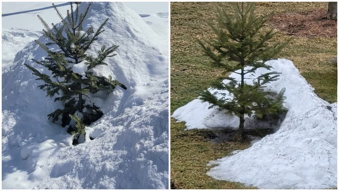
I have a small balsam that came from deep in the Northwoods 3 years ago. Always feed it plenty of snow so it grows in its natural habitat
. It had quite a drink this week.

-
5
-
-
A cold, white February finishes mild & bare.
Definitely a very unique Jan-Feb here with the ground having at least some white nearly all the time, but only 1 good week (mid Feb) of deep snow.
Only 3 of the 55 days from Jan 3 - Feb 26 had 0 snow depth at DTW. The DTX NWS office, located in the higher/colder elevations of northern Oakland county, has had continuous 1"+ snowdepth the entire time (and still reports 2" today).
Daily Snow Depth Data for Detroit, MI
2025-01-03	T
2025-01-04	T
2025-01-05	T
2025-01-06	T
2025-01-07	T
2025-01-08	T
2025-01-09	T
2025-01-10	T
2025-01-11	4
2025-01-12	3
2025-01-13	3
2025-01-14	3
2025-01-15	4
2025-01-16	4
2025-01-17	4
2025-01-18	2
2025-01-19	2
2025-01-20	2
2025-01-21	2
2025-01-22	2
2025-01-23	2
2025-01-24	3
2025-01-25	3
2025-01-26	2
2025-01-27	2
2025-01-28	1
2025-01-29	1
2025-01-30	T
2025-01-31	0
2025-02-01	T
2025-02-02	T
2025-02-03	1
2025-02-04	0
2025-02-05	0
2025-02-06	T
2025-02-07	T
2025-02-08	T
2025-02-09	1
2025-02-10	1
2025-02-11	1
2025-02-12	T
2025-02-13	4
2025-02-14	4
2025-02-15	3
2025-02-16	6
2025-02-17	7
2025-02-18	7
2025-02-19	6
2025-02-20	6
2025-02-21	6
2025-02-22	5
2025-02-23	5
2025-02-24	4
2025-02-25	2
2025-02-26	T
2024-2025 La Nina
in Weather Forecasting and Discussion
Posted
Just goes to show the different patterns in different regions. La Ninas arent necessarily a bad thing here tho, and those early 1930s winters were very mild. On one of my snow sheets I jotted down some highlights of this crappy time in our snow climo. Some of the highlights (or should I say lowlights):
1931-32: still stands as 2nd warmest winter on record
1932-33: After Jan ’32 saw just 0.9” snow, Jan ’33 sets the all time low with 0.4”
1936-37: still stands as least snowy winter (12.9”) on record
1937-38: largest storm just 2.4”; the 5th consecutive winter without a 5”+ storm
1941-42: mild winter; max snow depth 3”; only 1 winter of last 6 has exceeded 4” depth!
1943-44: mild winter nonexistent til Feb, but Feb sees the decades ONLY 6”+ storm!
1945-46: 2nd “Morch” in a row; no measurable snow after Feb 27, earliest on record
1948-49: 13.7” total snow, only 17 days with snow on ground, max depth 4”
1952-53: 16.6” total snow; Max depth of entire winter 2”, lowest on record
1957-58: 18.0” total snow, biggest storm just 2.1”, the smallest “biggest of season” on record
1960-61: cold but only 18.0” of snow; everything hit the east coast
1965-66: warm wet start then cold & very dry; only 15.4” snow
1968-69: 17.1” snow, the 7th sub-20” winter in 33 years! The last time Detroit didn’t hit 20”+
Snowiest winter of 1930s: 66.5” in 1929-30
Least snowy winter of 1930s: 12.9” in 1936-37
Warmest winter of 1930s: 1931-32 (stands as 2nd warmest)
Coldest winter of 1930s: 1935-36 (stands as 9th coldest)
Snowiest winter of 1940s: 44.4” in 1942-43 (snowiest winter of decade is our current avg)
Least snowy winter of 1940s: 13.7” in 1948-49
Warmest winter of 1940s: 1948-49 (stands as 17th warmest)
Coldest winter of 1940s: 1944-45 (stands as 21st coldest)
Snowiest winter of 1950s: 58.6” in 1951-52
Least snowy winter of 1950s: 16.6” in 1952-53
Warmest winter of 1950s: 1952-53 (stands as 15th warmest)
Coldest winter of 1950s: 1958-59 (stands as 18th coldest)
Snowiest winter of 1960s: 50.6” in 1966-67
Least snowy winter of 1960s: 15.4” in 1965-66
Warmest winter of 1960s: 1965-66 (stands as 45th warmest)
Coldest winter of 1960s: 1962-63 (stands as 5th coldest)