

michsnowfreak
-
Posts
17,085 -
Joined
-
Last visited
Content Type
Profiles
Blogs
Forums
American Weather
Media Demo
Store
Gallery
Posts posted by michsnowfreak
-
-
2 hours ago, Powerball said:
I started to posted exactly that in response, but yeah. You're spot on, lol...
EDIT: Funny thing is, after 3 top 20 hottest Summers in a row before 2025, this Summer's looking to be more on the normal (if not cooler) side with no real heatwaves on the horizon for us. We still have yet to see our first 100*F+ day and should close out June without one.
My aunts sister has lived in Texas since the late 1970s and HATES the summers down there. She always says that no one goes out during the day.
Obviously you can adapt to an extent to long winters or summers, but people will always have preferences.
-
 1
1
-
-
Final heatwave numbers for Detroit:
6/21- 92 / 68
6/22- 94 / 78
6/23 - 95 / 75
6/24 - 95 / 76A solid heatwave, but one as roardog and I noted before it began, that would be more impressive for lows than highs. The only record high, a tie, was on 6/23, and that was low hanging fruit to begin with. But 3 consecutive days set record warm lows (6/22-24).
To put this into perspective, in Detroits climate record: The hottest this heatwave was 95F and there have been 197 days with a high or 96F+ on record. The warmest low was 78F, and there have only been 9 days with a higher min (*there have been 10 other days matching the low of 78F).
IMO this will likely end up the worst heat of the year.
-
I shared a post that a meteorologist posted and tcc loses his shit. Yet he freely posts things all the time from other sources without checking. Its nice to know that from here on tcc will only be concerned about daily temp departures. No more notes about 1am temps or what not!
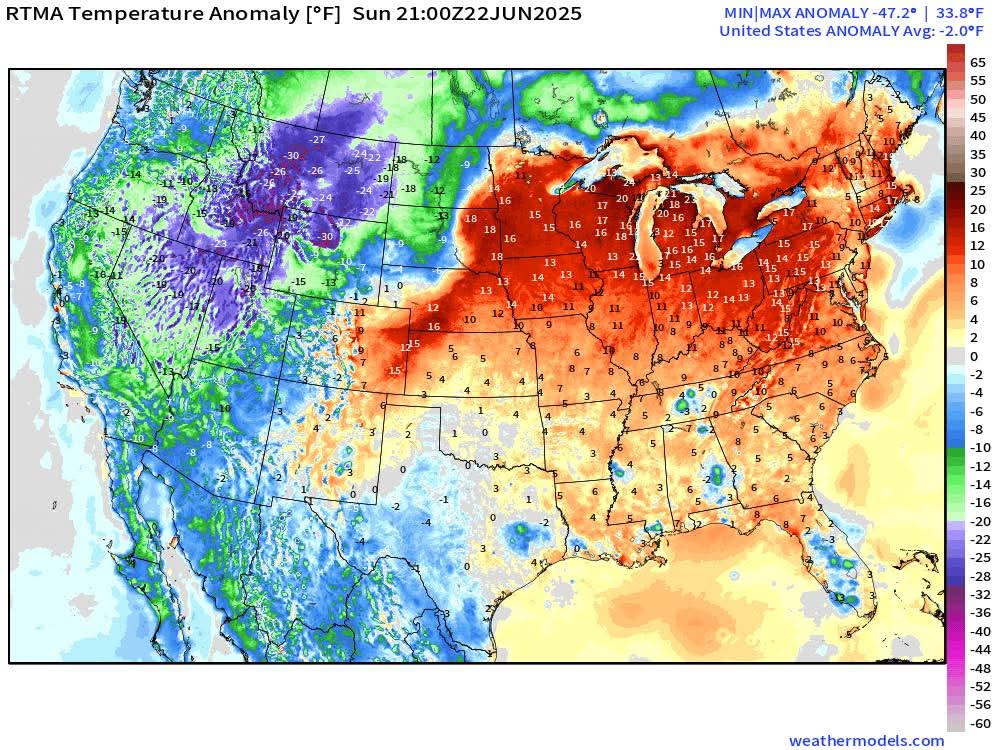
Ok so per that map, 21Z temps were -2.0° below avg in the U.S.
-
 3
3
-
1
-
-
Interestingly the U.S. was 2° below normal yesterday
-
2
-
 2
2
-
-
35 minutes ago, Harry Perry said:
Until Saturday. Looks like we’re headed back to the hills with high heat indices for the weekend into the beginning of next week.
More heat and humidity coming....but not like what we just saw
-
1
-
-
1 hour ago, Stevo6899 said:
They say the same when they have those rare days in the 40s. Thats us for atleast 5 months. All depends on individuals tolerance. I think most people would take warmth over arctic air.
Actually I disagree if we are talking extreme heat vs extreme cold. I think majority of people would rather have neither but would take extreme cold over extreme heat.
And lol we get way lower than 40s for months. They could never even have a michigan Fall day let alone winter day. But these past few days are right on par with many Florida summer days. Thank goodness it was only 3-4 days.
-
2
-
1
-
-
1 hour ago, nwohweather said:
I feel like I’m back in South Carolina with this heat wave. Pretty impressive to see these level of dew points
Whenever we get weather like this I always think how AWFUL it would be to live in the south. We have to deal for 3 or 4 days. This is their entire summer.
-
2
-
1
-
 1
1
-
-
Detroit hit 95° today, which tied the record from 1923 & 1911. Today's record was fairly low hanging fruit compared to all surrounding dates.
As expected, this heatwave will be much more noteworthy for its lows than its highs. The highest for Detroit should be today's 95°. By comparison, since 1874 there have been 197 days when the high was 96° or hotter.
-
2 hours ago, roardog said:
The impressive part of this heat wave is just the atmosphere staying well mixed during the night causing such high minimums. The fact that we're so close to the most daylight of the year probably helps too. The high temps haven't been anything special at all around here.
I agree. The nights have been very warm and muggy. The high temps have underachieved each day, although you and I discussed that as a likely scenario before the heatwave even started.
Yesterday was surprisingly more oppressive than today. I expected today to be the worst.
-
2 hours ago, TheClimateChanger said:
Wow! I didn't even realize it was that hot in Michigan.
The low of 80F at Saginaw breaks the all-time record high minimum temperature there by 2F. The old record of 78F was set on July 1, 1931 & August 1, 2006. The old monthly record of 77F was last set on June 30, 2018.
The low of 79F at Flint breaks the monthly record high set on June 20, 1953 by 1F, and ties the all-time record high minimum of 79F, set on July 18, 1942.
Lansing Area, with records dating to 1863, also set a new monthly record high minimum and tied the all-time record minimum of 78F. The prior June record of 77F was last set on June 30, 2018. The all-time record of 78F was set previously on July 18, 1942 & August 1, 2006.
The low of 80F at Holland, ties the June monthly high last set on June 15, 2022.
The low of 77F at Houghton Lake set a new monthly record high. The old record was 75, set on June 30, 2018.
The low of 78F at Detroit was one shy of the monthly record in the threaded history. It was 79F on June 25, 1952, when observations were taken at City Airport. Incidentally, it matched that reading at City Airport this morning. The all-time record is 80F, set 4 times in July and once in August, with the most recent occurrence being August 1, 2006.
There have been 5 official occurrences with a low of 80° at Detroit:
July 5, 1921
July 1, 1927
July 1, 1931
July 18, 1942
August 1, 2006
There have been 4 occurrences with a low of 79° and 11 times with a low of 78°.
The warmest recorded low at Detroit city airport was 82° on Aug 24, 1968. There were also 7 occurrences with a low of 81° and 8 with a low of 80°.
-
The low of 78 at Detroit breaks the daily record and is the warmest low since July 5, 2018. The all-time warmest min for Detroit, set 5 times, is 80.
-
 1
1
-
-
On 6/20/2025 at 4:51 PM, michsnowfreak said:
Tomorrow will be the first 90 of the year for DTW. The avg first is June 10th.
DTW did hit 92 but Detroit City and Mt Clemens only hit 89. I suspect I only hit 88-89 on the east side by the water. A bit underwhelming for day 1 but the main heat should be tomorrow thru Tuesday.
-
16 hours ago, 40/70 Benchmark said:
I also think we may see a pretty fast start this December...will get into why later in the season, but it originates from the QBO/solar stuff.
We are due for a snowy December.
-
13 minutes ago, TheClimateChanger said:
Lol, I remember you mentioning that earlier this winter I believe. The highway probably is probably situated in a low-lying area below the airport. I mean airports tend to be on somewhat higher ground for obvious reasons. I actually remember you mentioning that earlier. In the original post, you noted your car thermometer generally runs higher - which, of course, makes sense as, in most cases, heat would be radiating from the pavement/asphalt. But you know when there wouldn't be much heat flux? Hmm, probably near sunrise in midwinter.
In fact, under optimal radiational cooling, the roadway surface would actually drop below the air temperature. You are comparing a thermistor, which certainly isn't as accurate as a platinum resistance thermometer, to begin with, that's housed about 1 foot off the ground to a 2M surface temperature. It doesn't surprise me under those conditions; it would read several degrees lower. It's sampling air way below the proper height and in a local "frost hollow" south of the airport. You do realize that, under optimal radiational cooling, there can be a substantial temperature inversion in the lowest several feet of the atmosphere above the ground, right? That's why it can be in the mid/upper 30s at 2M, but with frost laying on the ground.
I would never take a car thermometer reading at face value (in the old days we used to have the old bank clock joke with @A-L-E-K). I was just pointing out that the varying temperatures in that area are obvious.
-
2
-
-
1 minute ago, TheClimateChanger said:
Not at Detroit, it isn't. The long-term mean is June 18th. Three years saw 0 90+ days (1882, 1907 & 1915), and therefore aren't included in the analysis.

I was using the 30 year avg. Which is June 10th. The POR avg is June 18th.
-
Tomorrow will be the first 90 of the year for DTW. The avg first is June 10th.
-
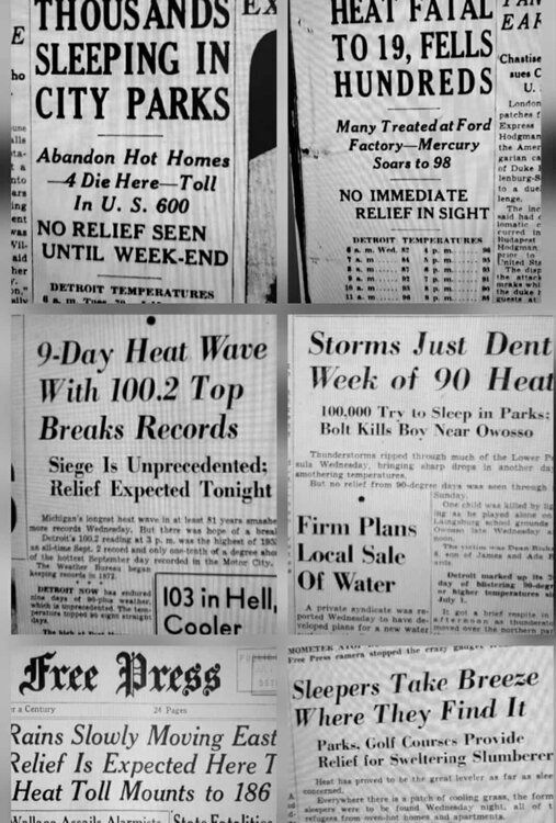
Heatwaves were just brutal in the 1930s-50s...with no AC
-
3
-
-
23 hours ago, TheClimateChanger said:
I'm not cherrypicking anything. Just looking to learn more about the DTW urban heat island. Those temperature variances strike me as primarily a function of elevation and latitude. Urban heat island may add a small component. White Lake is several hundred feet higher in elevation and, as you said, 40 miles northwest. FNT and MBS are way to the north, and FNT is also a few hundred feet higher in elevation. Even Ann Arbor gains elevation, although it might be small if along Allen Creek. Of course, if the station is near the creek, it would likely be in a particularly cool microclimate for radiational cooling conditions.

DTW is located in Romulus, MI. Areas near the airport range from suburban to even semi-rural. Though I currently work from home, from 2015-2021 I had a job where my commute involved passing the airport daily. I became WELL versed in how the temps work (I would pass just south of the airport and then get on the freeway which would drive right past then north of the airport). Temps just south of the airport are an Ann Arbor like bowl of extreme radiational cooling. Talking a quarter mile south of where the airport ends (intersection of Eureka & Middlebelt Rd). I saw this on a daily basis, often passing by at 730am, and the most extreme example I saw was on Feb 20, 2015 when my car read -22F at this spot but the official DTW low was -13F. For whatever reason, the temp always reads lower on the south side of the airport than the north side (where ASOS is). The temps at DTW would consistently come up on the high end of what was reported nearby, but certainly within range.
UHI is certainly a factor in big cities, but I feel its more of an "airport heat island effect" at many of the big airports. DTW has grown into a huge airport with numerous runway additions and expansions, the most recent being 2019-20. Even though the ASOS is in a well protected area, theres almost certainly a slight impact from all the nearby concrete runways, especially since the more rural and wooded areas less than a mile outside the airport property run slightly cooler 24/7. I dont feel its a major issue as long as the NWS keeps the thermometer properly calibrated, nor do I feel they should be taking temps in the microclimate of cold readings just south of the airport (as thats not representative). I simply want temps to be representative of what the nearby area is, and with most major sites being at airports its just how it goes. Snow is measured just off site at a park area...would be interesting if there was a thermometer there to compare.
Once we get away from DTW to the north and west, there are big elevation difference and some more alternating of bustling areas mixed with rural mixing bowls of raditaional cooling. And then to the northeast is a marine influence. So there are so many variables at play. As long as readings are accurate, thats all I ask for.
For instance, with this heat coming, id rather set a record high of 100F with dews in the 60s rather than have it be 93 with a dew of 75. But mother nature makes the call.
-
1
-
-
2 hours ago, LibertyBell said:
Chris would you have said this before 2013-14 and 2014-15 too?
One thing about climate change, it means more extremes, more droughts more rain and snow, and more extreme temperatures (maybe more likely in winter than summer.)
Exactly. Im sure he would've said this before 2013. All this talk about a warming base state and yet the very first winter after this "2023-24 warming base state" was colder than average.
Seeing the magnitude of some of the cold blasts we have had since 2016, despite overall domination of milder than avg winters, really makes me disagree with his assertion. As has been said many times, you dont talk about the future in absolutes.
-
2
-
-
1 hour ago, TheClimateChanger said:
You should be very pleased with my Michigan round-up then! You are the one who has thrown out comparisons to White Lake, Flint, Saginaw, and Ann Arbor in the past - all of which were warmer than DTW in my summary, some by several degrees.
This is exactly what I and others mean about cherry picking. You are picking one random day where temps were 1-2F warmer at those locations than Detroit. I can assure you it wasnt close to 90F here the other day. Everyone in THIS immediate area maxed at 85 or 86. Detroits annual temp runs about 0.5-1F warmer than Ann Arbor, 2-2.5F warmer than Flint/Saginaw, and 3.5-4F warmer than White Lake. It does not mean there wont be days where DTW is cooler than the others.
But my point stands. If DTW (or any site really) temps are in line with all other locations in the immediate area, I have no issue. My issue is when one random site runs 2-4F warmer than anyone else nearby with no clear reason it should (ie marine influence would be an example of an exception). Thats why the NWS ensures first order sites are properly maintained and calibrated. Its no secret that you WANT sites to run falsely warm, so when they dont, you resort to posts like this.
-
1
-
-
37 minutes ago, LibertyBell said:
How was 1983-84 for you? We had a very hot summer that culminated with 7 days of 90+ in September including a sizzling 99 on 9/11 (our latest 99 ever) and a 95 on 9/23 lol. 1983-84 was a very cold la nina here with a couple of moderate sized snowfalls,. 4-5 inches that stayed on the ground a long time and we even went below zero (which we did in a few years during the 80s, Christmas 1980, January 1982, December 1983, January 1985.)
It was our hottest summer on record before 2010.
1983-84 was a good winter! Cold and snowy. No memorable storms but 51.8" of snow overall and temps well below avg (28th coldest on record). We saw the coldest temp on the 21st century with -21F on Jan 21 (not to be confused w/ the coldest day, Jan 19, 1994, high -4, low -20).
-
2
-
-
63, cloudy and a NW breeze at 1pm. Hard to believe whats lurking.
-
49 minutes ago, PhiEaglesfan712 said:
No, 1877-78 was the super el nino. 1881 came off a weak el nino, and began a 3-year ENSO neutral period.
Just goes to show enso isn't always the culprit. After a hot September, the winter of 1881-82 was awful. Warm and snowless. Stands to this day as Detroits warmest (and 2nd least snowy) winter on record. Coming after the severe winter of 1880-81 it must've been a nightmare
-
15 hours ago, roardog said:
Yeah. If dewpoints really are in the mid 70s, I wouldn’t be surprised if we see a lot of low 90s for highs. Nights on the other hand are going to be awful.
Dewpoints in the mid-70s would be choking. Obviously big heat is coming, but models have constantly overdone heat for us the past several years. I dont think we see highs in the mid to upper 90s with lows in the mid to upper 70s. I feel it goes one of two ways. Either we DO see highs in the mid to upper 90s but cool off to at least the low 70s at night, OR we stay in the mid to upper 70s at night but only warm to the low 90s due to the humidity. I can see maybe one day of, say, 96/76, but not 3.
-
1
-
1
-
2
-

Late June 2025 Heat Wave
in Lakes/Ohio Valley
Posted
Well now yes she's older. As I said she's lived there since the late 1970s. Im just going by what she says. I have never been to Texas and have no desire to go. Ive been to Florida several times with no desire to return.
Like I said its all personal preference. It had been a very pleasant start to summer but all it took was a 4 day heatwave for me to say I've had enough lol. Give me arctic air anyday.