

michsnowfreak
-
Posts
15,699 -
Joined
-
Last visited
Content Type
Profiles
Blogs
Forums
American Weather
Media Demo
Store
Gallery
Posts posted by michsnowfreak
-
-
1 hour ago, mississaugasnow said:
@Snowstormsthis has potential to be biggest storm after March 15th in a generation
Wow. Just curious? What kind of numbers are you talking for it to be biggest in a generation.
-
Had a dusting of snow yesterday morning, just 0.1" here and at DTW but north of Detroit had anywhere from a half inch to as much as 1.5" near Flint. Was a cold and blustery day with windchills in the teens, classic strong nino wintry start to spring.
-
7 hours ago, Lightning said:
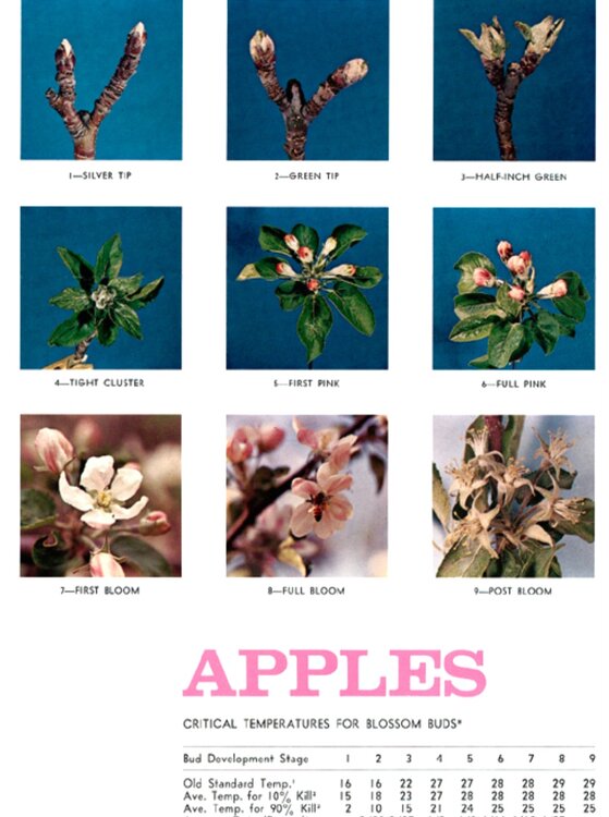
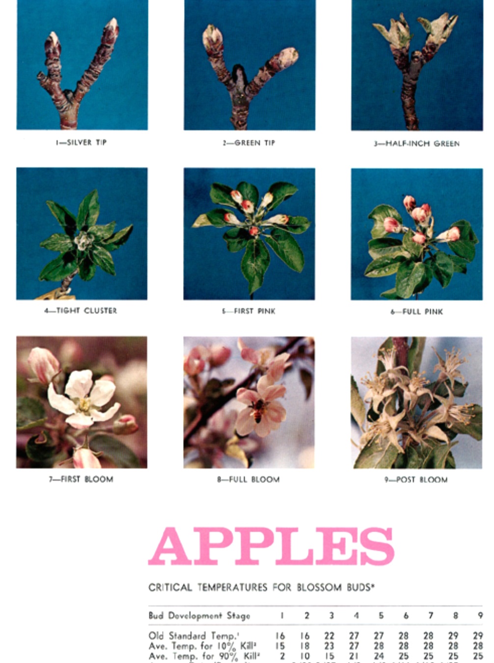
Around this area some apple buds are silver tip but most are not even that far yet. Further south and west of here in MI I bet there are more silver tips but I don't think much past that stage in at least most of MI.
I have 2 apple trees planted in fall. They are at stage 2 on the chart.
-
 2
2
-
-
2 hours ago, Lightning said:
Looking at the current condition of the buds, I don't believe there is any concern yet around here. From my experience with apple, cherry and peach trees is that the damage occurs once the blossom is out (or just popping out) and you get a good freeze or strong frost. When I was travelling this past weekend I didn't seem many blossoms until I got around and south of Springfield IL. St. Louis all the way to Oklahoma City area there were several trees in full blossom. A major freeze in those areas would be bad for them.
What made Morch 2012 so bad is the flowers came out but the bees were not out. While the later freeze did cause some damage, most blossoms never got properly pollenated.
Here's a guide for Apple trees
-
2
-
-
1 hour ago, GaWx said:
Anyone want to bet that Joe Bastardi won’t go 3+ F warmer than normal for the bulk of the Ohio Valley, Mid-Atlantic, and New England for his FINAL winter forecast for 2024-5? I’m not talking about any preliminary forecasts. I actually hope I’m wrong because I’d like to see him do it for a change for his final. I can’t tell you how long it has been since he did just that. One at the very least has to go back to 2013-4 for the final one to be that warm.
His preliminary winter forecast for 2020-1 was ~+3 to +4 for the bulk of the Mid-Atlantic and much of the Ohio Valley (New England was +2 to +3):
But then he cooled it way down for the final to mainly +0.5 to +1: that’s why I say wait until the final is released

Assuming that's a typo on the bottom graph (meaning it should be 2020-21) I'd have to say his forecast was dead on here. The "normal" line runs through Detroit and DTW finished the winter +0.1°.
Also, am I reading correctly? Did he actually forecast 2013-14 to be a warm winter

-
1
-
-
On 3/16/2024 at 12:24 AM, George001 said:
One of the things I like about La Nina’s is you know what you are going to get with the winter by mid-late December. The good Niña winters you get buried early. If it’s a Niña and Dec torches, there’s no “oh maybe it will turn around”, it means the winter is cooked. Where as with this winter, many of us spent 2 months chasing ghosts before it became clear we were starting down a ratter. With a Niña, that false hope doesn’t exist. On the other hand if we do get snow in December, it’s a lot more fun to track storms because you know more is coming at some point.
Interesting. I would not say "you know what youre getting" about Ninas here. I wonder if @40/70 Benchmark would agree for your area? Many Ninas here are front loaded, some backloaded, but usually theres a notably harsh portion of the winter and a notably meh portion (not always - see 2007-08 or 2010-11, wall to wall fun). I specifically remember that the 2000-01 winter was all midwest Nov/Dec then all northeast Jan-Mar, though I cant recall if that was an exception or the rule. Im really anxious to see if we can get one of those good, snowy Decembers because thats what we are due most for (and its also one of the snowiest months in Nina winters here).
-
On 3/15/2024 at 7:30 PM, LibertyBell said:
la ninas after el ninos are some of our snowiest seasons on record.
It happened in both 95-96 and 10-11
I know some have been mediocre, but I like this combo.
I would take my chance with ANY Nina here, but particularly 1st year Ninas. Whats funny is that 1995-96 was a really crappy winter here in that it was very cold and dry. We missed snow to the N, S, E, & W. A 6" snowstorm on the 1st day of spring 1996 "rescued" the season, DTW finishing at 27.6". Its rare that NYC beats DTW in seasonal snow, and that year they annihalted us with 75.6". It was a great year for lake ice and what not, but one of the shittier Nina snow seasons. But 2010-11? Now you are talking (69.1" at DTW, 61.9" NYC).
As long as you give us a storm track, mild and even warm winters can do fine with snowfall (but of course the warmer it is, the worse snowcover is), so I guess in hindsight, 1995-96 was the MUCH rarer opposite problem- plenty of cold, missing all the storms (except clippers), no help from the frozen lakes.
-
1
-
-
Flurries have filled the air almost nonstop yesterday and today but just a trace here. Missed some of the heavier squalls that coated the ground elsewhere.
-
1
-
-
8 hours ago, IWXwx said:
Hi
% of avg
2015-'16 21.9” 65%
2016-'17 14.8" 44%
2017-'18 27.9" 83%
2018-'19 28.9" 86%
2019-'20 27.5 81%
2020-'21 35.9" 106%
2021-'22 24.4" 73%
2022-'23 19.5" 58%
2023-'24 10.9 35%
You are definitely due! Hopefully next winter.
-
5 hours ago, OrdIowPitMsp said:
Any disappointment I had from missing out on futility was replaced by watching the joy on my kids face. If it ends up being rain or snow, I don’t care at this point. I’m just glad there’s something of interest to track again and hopefully knock back the drought concerns.
Cute! Oh trust me, under no circumstances would I ever root for futility lol. I went sledding in Jan...always a kid in winter!
-
1
-
-
4 hours ago, Powerball said:
Would be crazy if it did happen though.
The comeback of the century...
While I'm sure they won't get that much, there's definitely a significant signal for snow in the northern part of the country the last half of March. This is why I always say to those talking futility in January or even earlier that the snow season has so long to go, you really have to have EVERYTHING go wrong to get that. I can't think of a more deserving season than this one for the Northwoods, but mother nature may have other plans. Duluth still in the running, but Minneapolis screwed that up by being in the jackpot of that February snowfall. Here in Detroit, I cannot remember a more benign winter outside of one month, but since that 1 month produced 17 inches of snow, again, top 10 futility off the table. Toledo is surprisingly still in the running for their 2nd least snowy winter.
-
2
-
-
8 minutes ago, LibertyBell said:
weak la ninas can be great and sometimes even moderate ones are good-- we just need to get out of this rut of warm Decembers.
No better time to start than a 1st year Nina. I know each ENSO strength has different effects between the Great Lakes & east coast, but the number of good Nina Decembers here is intriguing to me. Everything snaps at some point. We were having a historic run of snowy Februarys, then bam, 2 crap ones in a row. Likewise, a run of shitty Decembers can turn around at any point.
-
1
-
-
4 minutes ago, andyhb said:
The fatalities in Winchester were redacted later. I think someone got "casualties" lost in translation or something of the sort.
So 6 confirmed dead in total? All at the OH trailer park?
Those videos were scary.
-
1 hour ago, roardog said:
The ‘22-‘23 winter was probably about the worst Nina pattern we can get for this area. The western trough/eastern ridge is expected in a Nina but it was amplified to the extreme. If it would have been even a little less amplified, it would have been much more interesting here. It was great for Minnesota though.
Exactly. Although it was also a 3rd year Nina. Not sure how you did up there, but a snowy March definitely brought the season total into respectability range in the metro area. This winter of 2023-24 was in a league of its own that fortunately we rarely see.
-
1
-
-
On 3/13/2024 at 1:07 PM, Terpeast said:
Still a warm signal. Even if only +2 based on older analogs (pre 2016 super nino), one would need to adjust to today’s climate. Like +4 or something like that.
Adjusting +2 to +4 for "todays climate"? I would not consider the fact that 5 of the past 9 winters have been very mild up here enough to double a departure on a set of 4 analogs which include the cold winter of 2008-09, and the mild winter of 1998-98, especially since winters of the mid-late 1990s were far milder here than winters of the 2000s to mid-2010s. Yes, we have certainly made a turnaround with that strong Nino in 2015-16, but each winter has their own character. Historically the roller coaster pattern of a La Nina, while frustrating to us snowcover lovers, is what can aid in a banner snow season in MI (see 1998-98, 2007-08).
-
On 3/13/2024 at 9:38 AM, roardog said:
If we could end up with a +2 next winter, it would feel like living in the Arctic compared to these past two winters.
The more important takeaway for our region is in Ninas, the good snow seasons outnumber the bad handily.
-
1
-
-
Memories have frequently been popping up on Facebook of stories on the record snow, cold and ice 10 years ago. What about insane difference (2013-14 vs 2023-24).
-
8 hours ago, roardog said:
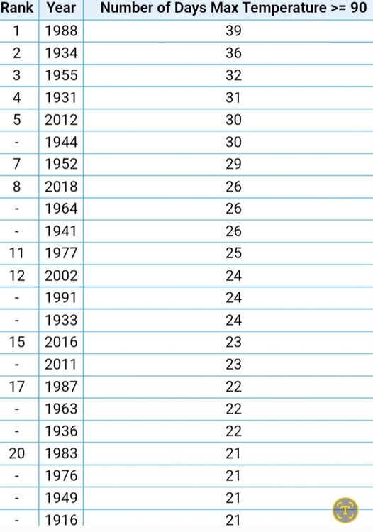
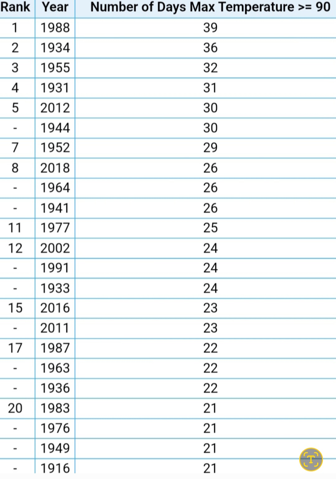
As has been discussed a gazillion times on here, the 1930s heat was different than what we’ve experienced in recent years. Recent years warmth is due to higher dewpoints causing warm lows. The 1930s heat is low dewpoint record highs. The only years of my life that might be comparable are 1988 and 2012.
For a visual aid, see above. It's like talking to a brick wall. Mean temperature vs max temps are two different things. It would be like comparing six 2" snowfalls to one 12" snowstorm.
Last summer the hottest temperature at DTW was 90°. To be honest I would prefer a hotter dry summer over a warm humid one.
Considering last year was overall a very pleasant summer in an era of hot summers, and we have an El Nino transitioning to La Nina, I definitely am expecting a hot summer this year. But it would be interesting if we could actually get heat waves and some cool shots instead of just steady warm and humid.
-
2 hours ago, roardog said:
As has been discussed a gazillion times on here, the 1930s heat was different than what we’ve experienced in recent years. Recent years warmth is due to higher dewpoints causing warm lows. The 1930s heat is low dewpoint record highs. The only years of my life that might be comparable are 1988 and 2012.
A gazillion times is an understatement. Those who have a one-track agenda when it comes to weather will always simply use whatever works best for them at that specific moment (mean temp, most/least hot maxes, most/least cold mins, station/instrument placement, snow depth vs snowfall, snowfall was less at a station 100 miles away, "since 1970...", etc etc...or if ALL else fails, "I dont trust that data for X reason"). Consistency is never a strong suit
 . The same passion that is used to reiterate that a snowy season in a milder winter was STILL a milder winter is completely MIA when it comes to acknowledging a deadly heatwave during a dustbowl year that wasnt the hottest summer on record.
Heatwaves of the 1930s-50s have yet to be matched locally. Very interesting era in weather (puny, mild, low snow winters and scorching heatwaves, also a lot of tornadoes). Those summers, while still high on the list of hottness, often had a few good cool downs and more importantly cool nights. Very interesting that we have no problem getting a roller coaster in temps during Winter, Fall, & Spring but summers anymore are full of stagnant days, humid nights, and warm humid days lacking extreme heat. As summer is also the season where mean temp is increasing the most, I plan to do some closer looking into those warm summer nights this year.
AVERAGE ANNUAL 90F+ DAYS PER DECADE AT DETROIT
1880s- 5
1890s- 9
1900s- 6
1910s- 11
1920s- 9
1930s- 17
1940s- 16
1950s- 15
1960s- 11
1970s- 12
1980s- 13
1990s- 12
2000s- 10
2010s- 16
2020s- 12 (only 2020-23)Heres an interesting stat - Average annual max temp by decade
1880s- 93
1890s- 95
1900s- 93
1910s- 96
1920s- 95
1930s- 99
1940s- 98
1950s- 97
1960s- 95
1970s- 96
1980s- 95
1990s- 96
2000s- 94
2010s- 96
2020s- 93 (only 2020-23) -
7 hours ago, rainsucks said:
ALL long-range modeling has been severely cold biased for quite some time now and cannot be trusted. bluewave has made some very informative posts on why this is the case and what can be done to improve the accuracy of long-range forecasting going forward.
The cold bias was worse this winter than normal. And last summer the extended had a heat bias. And we all know about the precip "clown maps". Always good to repeatedly remind yourself the LR is a guide, NOT a forecast.
-
1 hour ago, raindancewx said:
The El Nino finished at ~28.4C in Nino 3.4 for Dec-Feb. The years most similar to that were 1957-58, 1972-73, 1982-83, 1991-92, 1997-98, 2009-10. The roll forward is very much a Modoki La Nina look if you throw out 1958 and 1992 which are not La Ninas.
1973-74, 1983-84, and 2010-11 are actually pretty interesting winters with pretty severe cold shots at times in places you wouldn't expect given the overall patterns. I believe 1983-84 and 2010-11 had TX power grid destroying cold shots / Blue Northers.
I would take any of those 3 in a heartbeat (73-74, 83-84, 10-11).
-
4 hours ago, Chambana said:
Lawns are abnormally green for March 12th lol, I don’t remember this even during morch.
I don't remember March 12 in 2012, But I do remember the insane exploding of foliage by March 17-20, which almost certainly will remain king over this year, and any other year. Other very early green ups in my memory are 1998 and 2010. Looking at historically early documented greenups, 1945 and 1946 had extremely early greenups and 1945s fruit crop was essentially ruined. One early greenup that flies under the radar often is 1977. After a cold early Fall and brutally cold winter, spring sprung early with warmth and stuff leafed out much earlier than normal.
Im curious what happened during the spring of 1932. There was a lot of documentation of extraordinary winter blooming and blossoming of trees and flowers, which was then followed by a cold spring.
-
2
-
-
14 minutes ago, roardog said:
Nothing about the pattern on any of the ensembles look “warm” after this week. It’s all relative and doesn’t mean there can’t be a warm day or days in there but the overall look certainly isn’t warm. I mean we are talking late March so a high in the upper 30s would be well below normal across much of this sub by the end of March. Nobody is talking about days and days of mid winter cold.
Agree 100%. We all know the cold has failed this winter, and as you get to late March average has warmed significantly, so no one is talking mid winter cold for days. But its head-scratching to see how anyone can say the extended "looks mild/warm".
-
On 3/11/2024 at 9:34 AM, Build Back Better Winters said:
With red being 50-75% of normal, it’s not as bad as the colors look. For many, that’s only a couple inches less than normal because they get 5-7” or less on average.
On 3/11/2024 at 10:19 AM, nwohweather said:To be fair, there were some seriously snowy Winters in the 70s and 80s that skew this a bit. Heck the 1970's were so chilly there was some debate of global warming vs global cooling, even though the WMO was team global warming (which ended up being true)
On 3/11/2024 at 3:28 PM, Brian D said:LOL. Let's just pick 1974 as a start date. So funny LOL
Like there isn't data going back another 30-50 years at least.
Using 1970s winters as a baseline has been popular for years and will continue to be. When you use what is for most the harshest decade of winters on record as a baseline for "average", make increases in temps and (for some) decreases in snow more eye popping. The ever-popular "since 1970" will still be popular, but now that we have hit a nice round number of 50 years since 1974-75, that too should increase in popularity (especially we can add the last 2 very mild winters, and lop off the milder, lower snow seasons of '71-73). Lets face it, including the many mild and terrible snow seasons of the 1930s-50s would be a real buzzkill, so just start in the 1970s!
I verified the data for Detroit. Whats interesting is Mar snowfall did decrease from 7.4" to 5.5" (a ~25% decrease) but Feb snow INCREASED from 6.7" to 16.2" (a ~140% increase
). December saw a sharp decrease. Whats funny though is the annual snowfall remained the same to the tenth of an inch (44.9" to 44.9"). The previous 50 years (1924-1973) saw annual snowfall DECREASE by 6.6" & avg winter temps rise 1.4F.
Its all about how you make the graph work for you.
~If I look at the change in the last 50 years of Detroit winters, they have warmed 4.9F and annual snowfall has remained exactly the same (heavier mid-winter and lighter at the beginning and ends of the season).
~However, if I look at the change the last 100 years, the winters have warmed just 1.2F and annual snowfall has increased a whopping 13.3". It goes without saying that those puny mid-20th century winters hurt.
~If I look at the entire period of record, 150 years, Detroit winters have warmed 2.0F & annual snowfall has increased 0.6".
-
2
-

2024-2025 La Nina
in Weather Forecasting and Discussion
Posted
I would think 1973-74 is the best early analog in that case.