

michsnowfreak
-
Posts
15,699 -
Joined
-
Last visited
Content Type
Profiles
Blogs
Forums
American Weather
Media Demo
Store
Gallery
Posts posted by michsnowfreak
-
-
15 hours ago, Snowstorms said:
Pretty telling and concerning 7 of the top 10 warmest winters are in the last 27 years and 5 in the last 13 alone. Although a few others did not make the top 10 for Detroit, there's several other warm winters or winters with an abnormally warm month in that 27 year span including 1998-99, 1999-00, 2005-06, 2012-13, 2019-20, and 2020-21.
Warmth is one statistic and snow is another. I'm more concerned about the warmth and its severity and longevity during the winter season than whether we end up with above average snow. Because if we continue on this trend, we won't see many snow cover days or may struggle with precip issues with every storm. The period between 2007-2015 was the only real cold period filled with snow/cold that we honestly had since the 90's. And many of the 90's winters were shit too.
Obviously 5 of the last 9 winters have been very mild, ever since the strong 2015-16 nino, and they have made their way into the top 10. After 11th warmest, the next 10 warm winters are all old (1870s-1950s plus 1 in 1980s). With the always cyclical nature of weather patterns, enso, cc, there are so many factors at play.
I too agree that temps & snow are two different things. But with the type of winter climate we have, I don't think we will ever have to worry about struggling with precip type during "every storm". Even during the warmest winters you get cold storms. IMO the number of snowcover days would be the far bigger metric to watch to look for any notable decline.
At Detroit, the "barest" decade was the 1990s, then the 1930s, when looking at annual avg of 1"+ snowcover days.
1910s- 58 days1920s- 52 days1930s- 42 days1940s- 49 days1950s- 47 days1960s- 56 days1970s- 57 days1980s- 47 days1990s- 37 days2000s- 52 days2010s- 53 daysWe have 5 to 6 more winters to go before the 2020s are complete. That will be a good assessment time, because it really averages out all the ups and downs of the decade. This wild notion that some have that the weather used to be consistent always blows me away because the weather has never been consistent here. I find that a slight bit of Winter warming is more of a help than a hindrance here snow wise. What I want to avoid is many winters like this disaster we just went through. -
Everyone better hope for widespread clear skies on April 8th.
-
 1
1
-
-
Ended up with 0.71" here. A long drawn out light rain.
-
4 hours ago, Geoboy645 said:
According to Xmacis, looks like April 6th, 1912 is the latest Minneapolis crossed the 1" mark for the year. Interestingly enough, that was also a Nino albeit it only got 1.4 instead of 1.8 departure. The difference however is that 1911-1912, especially January 1912, was one of the coldest winters ever for the Midwest. Like Minneapolis averaged a *checks notes* -18.9 departure for the month in January (!). Quite the opposite of this winter to say the least.
Minneapolis has only had two years on record where less than an inch of precip had fallen thru March. 1958 (strong El Nino) and 1912 (weak el nino). 2024 (strong el nino) could be the 3rd.
-
5 hours ago, Baum said:
who wants it? But inevitable. Hopefully, short and moderate at worst.
Im fine with anything other than a torch. No shame in liking the cold when theres others who root for early warmth that just destroys fruit crops. The one thing about weather that IS constant though, is it does what it wants, not what we want lol.
-
 1
1
-
-
51 minutes ago, WinterWolf said:
This year here is better than both of those….it all depends where you are. Still a Rat, but just not the The King Rat.
I've looked into it because Boston and Detroit share all time ratter- 1936-37.
In 1936-37, Boston saw only 9.0", but of that 4.4" fell in November. Most of it was a 3.8" snowfall on Nov 24 which was down to a T on the ground that day. After that Nov 24 snowfall, Boston only had 3 days the entire rest of the season with 1" snow depth (and that was rounded from snowfalls under an inch but greater than a half inch). So officially 4 days had 1+ snowcover (4, 1, 1, 1).
At Detroit, both the season total of 12.9" & total of 10 days with 1"+ snowdepth also hold the all time futility spot.
While other places didn't fare quite as bad as Detroit or Boston, it appeared to be a terrible snow season pretty much everywhere in the eastern half of the US.
-
1 hour ago, Build Back Better Winters said:
Meh, doesn’t look very cold though, slightly below average at best.
I mean it's too early to tell. But the 850s on all ensemble means are impressive, and that will make its way to the surface to at least an extent. By no means am I implying this is midwinter deep cold, but unseasonably cold weather on the lap of spring after a mild winter is a classic strong nino signature in this region, so the fact that the models are showing this is no surprise. Before the cold hits however, another warm spell looks to hit next week after a brief weekend cool down here.
-
Looks like one of those classic strong nino cold spells to welcome the spring equinox

-
 2
2
-
-
37 minutes ago, ma blizzard said:
wow we lost another one to the snow blow gang? sad news hate to see it
I have to chime in on this. I love big snow piles too, but I gave in to a snowblower 3 years ago. Just too much physical work. I still shovel smaller events, or the wet snows the blower gets stuck with, but definitely love having a snowblower. I used to be a "snowbank sculptor" and the banks were insane back in 2014, higher than my 6'5" self. But just too much now.
Back in January, I was driving somewhere with my mom and happened upon the rare sight, in a residential neighborhood, of 4 houses in a row that clearly shoveled everything. The snowpack was about 7", but was the product of several layers of snow/settled snow. The visual difference of those homes versus the rest of the neighborhood with its perfectly crafted snowblower lines, and only a bit of piling at the corners, was as if it was almost a double snowpack. Then it hit me. Snowblowers are THE reason why "old timers" claim it snowed more when they were a kid when it did not.
-
 1
1
-
1
-
-
3 minutes ago, 40/70 Benchmark said:
Like 63".
My low point is 19.9" in 1979-1980.
Oh wow, yes with a high avg like that, not good.
Id probably give winter here a D-. As horrible as it was, cannot go F with some incredible thundersnow & a 2 week stretch of deep winter in January. Plus of course, a strong Nino is the worst winters we get, so expectations were low to begin with.
If no more snow fell at Detroit, the 22.6" would rank as 13th least snowy winter (since 1880), but i have a feeling we will see some snow with the upcoming trough. While I totally get things like "if it werent for that 2 week stretch in Jan" for me, or "if it werent for that Jan 7th snowstorm" for you, they still DID happen. So it actually CAN be worse
Not to go OT but 1979-80 was a sort of fascinating winter in that snowfall was shitty across the board from the midwest/lakes right on into new england and the east coast, but the winter itself was not that mild outside December. Perhaps mother nature just ran dry after the 1976-79 stretch lol.
-
2 hours ago, 40/70 Benchmark said:
Think about this....I have 30" on the season and 19" of it fell on January 7. The rest of the winter I have 11".....which would be far and away my futility record.
My next largest event is 3.5" on January 17th.
What is your seasonal avg? 19" sounds like a hell of a storm but yikes on the rest of winter.
In my 29 years measuring snow imby, the low mark is 25.5" in 2011-12. This season I'm at 20.6" (avg is ~45") so far.
While not as crazy as 19" of 30" falling in 1 day, 16.0" of my 20.6" fell in January (17.0" of Detroits 22.6" fell in January).
-
1
-
-
39 minutes ago, WestMichigan said:
Mlive ran an interesting article recently. GRR had 15 days below normal for the entirety of met winter, MKG only had 12.
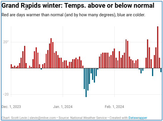
A crazy warm winter with one intense cold shot. The winter finshed +6.4F at DTW, and that one brutal cold week (Jan 14-20) had a departure of -10.0F
At DTW, the below avg days in DJF:
Dec 13: -2F
Jan 4: -1F
Jan 5: -1F
Jan 14: -18F
Jan 15: -23F
Jan 16: -17F
Jan 17: -15F
Jan 18: -3F
Jan 19: -9F
Jan 20: -14F
Jan 21: -9F
Jan 22: -4F
Feb 17: -5F
Feb 18: -1F
Feb 24: -2F
Feb 29: -2FDJF had:
Exactly avg: 4 days
Below avg: 16 days
Above avg: 71 days
-
 1
1
-
-
6 hours ago, PhiEaglesfan712 said:
List of strong and moderate la ninas since 1950 (based on Ensemble and NOAA):
Strong: 1955-56 (5 - considered Strong by Ensemble, Moderate by NOAA), 1973-74 (6), 1975-76 (5 - considered Strong by NOAA, Moderate by Ensemble), 1988-89 (6), 1998-99 (5 - considered Strong by NOAA, Moderate by Ensemble), 1999-2000 (6), 2007-08 (6), 2010-11 (6)
Moderate: 1949-50 (4), 1970-71 (4), 1984-85 (3 - considered Moderate by Ensemble, Weak by NOAA), 1995-96 (3 - considered Moderate by NOAA, Weak by Ensemble), 2011-12 (4), 2020-21 (4), 2021-22 (4), 2022-23 (3 - considered Moderate by Ensemble, Weak by NOAA)
Thanks for the list! What is the difference between Ensemble & NOAA?
-
7 hours ago, 40/70 Benchmark said:
1998-99 is one of the few milder winters I would NEVER say no to a repeat of lol.
-
19 hours ago, so_whats_happening said:
This year while in many areas wasn't great at all, there was one spot that managed to do well. PA was the hot spot for average to above average snowfall this year and at that a rather localized area from about Scranton to Allentown and back to about Harrisburg/ State College area. We managed about 18-19" on the winter which is below average on our 26" yearly snowfall. This was not a bad winter for our neck of the woods but last winter was horrific (0.9" for the entire winter). 2020/21 was our last above average winter (~34") and that came with a nice storm in February and a nice event from the huge storm that pummeled BGM back in December 2020.
At this point im rooting for a neutral event, while one year I would love to have a revisit of 09-10 pop up im on the lets get to average train at this point.
I have been noticing though when we do get these marginal events things are just a bit too warm for us anymore when we used to be able to manage to stay slightly on the cooler side of things. I do wonder if the warm Atlantic is causing this issue. That hurts us immensely on those quick pickups of 2-4" that would help get to near average.
Yeah, I noticed a couple decent events in PA. I have a friend in Hollidaysburg, PA (not sure which CWA that is) & he has posted a few good snowstorms. Last year we only finished slightly below avg snowfall in SE MI but Im one of those that figures cold & snowcover into the mix for how good, or not good, a winter is lol. The current avg at Detroit is 45", the longterm avg 41". Last winter saw 37.1" and this winter so far 22.6" at DTW. During these warmer winters, we get a few real good bouts of blinding snow, thundersnow, and extreme low ratio snow (case in point- Jan 12th saw 4.6" of snow on 1.04" liquid, nearly all snow) but its short on the deep winter feels.
Weve not really suffered too badly at all in the snowfall dept outside of this winter, but snowcover has taken a hit. The past 9 winters (im including this winter, so could always add a bit), ever since the infamous strong Nino of 2015-16 shook everything up, the avg snowfall is 40.1" & avg days w/ 1"+ snowcover is 40. The previous 8 winters the avg snowfall was 58.3" & 1"+ snowcover days 61. The longterm avg would be about 41" snowfall, 50 snowcover days. So not bad on paper at all, but a sharp reduction from a super snowy stretch, with 5 of the 9 winters being very mild to boot.
Im all for neutral too. It could shake things up for everyone. No matter how "good" or "bad" the pattern is, youll have winners and losers, but it seems neutral is a more favorable pattern for more widespread winter conditions.
-
My sister is 5 miles away from there and could see glow in the sky.
-
After recording 5.14" precip & 16.0" snow in January....I have seen a grand total of 0.17" precip & 2.5" snow since Jan 31st.
-
15 minutes ago, 40/70 Benchmark said:
As warm as the lakes have remained, not even enough cold could be mustered to avail of that via LES....the cold was all in Eurasia.
Yup. The arctic blast in Jan definitely got the Lakes moving, but theres only so much you can get in a 10-12 day period. Friend of mine who does plowing/salting had a 100-hour week in mid-late Jan and the rest of the season just isolated saltings and maybe 2 other plows.
I follow this group on facebook "view from my window" where people all around the world post pics of the view out their window, and seeing lots of people in Eurasia posting and "complaining" about too much snow. Lots of them saying things like "I like snow, but this is too much". Needless to say, snow lovers from the northern US from Minnesota to Maine did not appreciate the bragging
-
1 hour ago, 40/70 Benchmark said:
These are my thoughts on the next few years.....not too optimistic, but there is an end to this east coast horror show in sight, AFAIC.
Regardless, Id have to imagine this year is rock bottom for the east.
We havent been doing as widespread poorly in the midwest/Lakes for the most part, but this winter has to be rock bottom for the upper midwest especially. Even though they have had good snow years recently (just last year in fact), this winter is so unlike anything Ive ever seen for those places. To unseat the historic warm winter of 1877-78 (also a strong Nino) as many did is crazy. And I have NEVER seen a winter with near bare ground in northern MI in Feb.
-
When it comes to weather analysis, especially locally, I would give myself 10/10 in past climatology and probably 4/10 in all the other factors that make it happen (ENSO, NAO, PDO, etc etc). I understand what atmospheric factors are good/bad for a good/bad winter, but I am really novice when it comes to how they work together and definitely at how to forecast them (I dont ever forecast though lol).
I always look at ENSO as one piece of the puzzle. It may be the biggest piece, but there are lots of other pieces that will have somewhat of an effect. The mean of a strong El Nino here is a guaranteed mild winter, and snowfall/precip will very likely finish below normal. But what else happens and how extreme will be dictated by other factors, as sometimes late winter can get cold, and nearly unanimously December will be mild.
If i chop this winter into 3rd, by calendar month at Detroit, this is what I get:
DECEMBER 2023- 3rd warmest on record (40.1F), and tho precip was near normal, it was the 2nd least snowy on record (0.1"). Literally as bad as it gets (we did have snow on the ground last 4 days of November tho), but a warm December in a strong El Nino here is basically a 100% surefire bet. Just didnt expect it this warm.
JANUARY 2024- Temps only slightly above avg (27.5F) and this was due to excessive cloudiness causing higher mins. The avg high was actually -0.2F. It was the wettest Jan on record (5.25") and snowfall was above avg at 17.0". It was a good month overall, and the parade of nonstop snow, rain, and ice was quite a surprise for what is supposed to be a dry winter.
FEBRUARY 2024- 3rd warmest on record (37.1F) and 4th driest (0.24"). What a crazy switch from Januarys storminess, as El Ninos "dry" showed up in full force. Despite the warmth, nearly all of the minimal precip we did have was snow (3.1").
DJF 2023-24- 4th warmest on record (34.8F). Precip finished a little above avg (thanks to Jan), which goes against typical Strong Nino climo, although it was nowhere near the top 20 wettest. Snowfall finished below avg, but thanks to Jan, it too was nowhere near the top 20 least snowy DJF's.
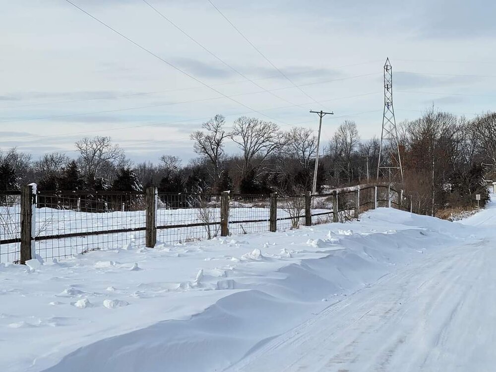
This is why looking at seasonal averages doesnt always tell the tale. We are all guilty of analyzing final numbers, but if you would have showed me a crystal ball and said these are the final numbers of this strong Nino, I would sigh and probably say "Typical strong Nino. Im not surprised". But I didnt dream the winter would be as wacky as it ended up being. Basically a nightmare of warmth that was masked by a 2 week siege of deep winter in January. We had wind chill warnings and advisories for like 3-4 days straight, and we can EASILY go a good, enjoyable winter without seeing any. Had it been even a more modest stretch of cold, this couldve been the warmest winter on record. The pic below was taken Jan 15th with a temp of 5F and wind chill near -30F. Definitely not my most scenic pic, but its one where you can "feel" the cold. I should change it to B&W and caption "taken during one of the warmest winters on record".
-
2
-
-
A memory popped up, reminding me that on this date last year we had that crazy snowstorm that came in like a wall of white, complete with thunder and lightning.
Got me thinking that in these horrible mild winters, we really can get a few good bouts of blinding snow. Its one of the FEW consolations of two shitty winters in a row.
Heavy snow with visib 1/4 mile or less:
Jan 22, 2023
Jan 25, 2023
Mar 3, 2023 TSSN
Mar 10, 2023
Nov 27, 2023
Jan 12, 2024 TSSN
Feb 15, 2024
-
1
-
-
1 hour ago, George001 said:
Yeah Im not asking for an incredible winter at this point. Give me normal temps + normal snow and I’ll be happy.
Me too! We are only on our 2nd subpar winter here, and that's MORE than enough for me. Last year wasn't too bad snowfall wise, but way too mild. This year absolutely sucked. This is my 29th winter of measuring snow in my backyard. My lowest snow season was 25.5" (2011-12) & highest 96.2" (2013-14). I have only received 20.6" to date this season.
-
11 hours ago, TheClimateChanger said:
Both of those were at lakeside observatories on a rooftop. C'mon man, you would have loved this. These are the glory days for Detroit.
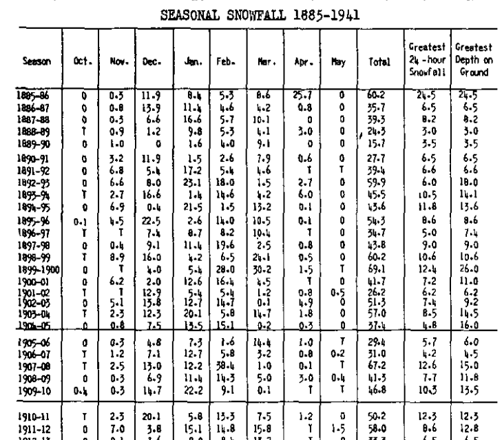
In the modern threaded record, there are only 15 years that had a peak snow depth of 12" or more at Detroit [out of 77 years]. The maximum is 24" from the winter of 1998-1999.
From 1885-1886 to 1911-12 (rounding to the nearest inch), the following peak depths were noted:
(1) 26" in 1899-1900
(2) 25" in 1885-1886 [in April, no less!]
(3) 18" in 1892-1893
(4) 16" in 1904-1905
(5) 15" in 1907-1908
(6) 15" in 1903-1904
(7) 14" in 1893-1894
(8) 14" in 1894-1895
(9) 14" in 1909-1910
(10) 13" in 1911-1912
(11) 12" in 1910-1911
(12) 12" in 1908-1909
(13) 11" in 1900-1901
(14) 11" in 1898-1899
That's 12 years with 12"+ more peak depth, and 14 with 11" or more, in just 27 winters, compared to 15 & 18 in 77 winters with daily snow depth data - including two years with peak depths higher than any observed in the most recent 77 winters. Look at the 24 hour snowfalls - at least 8 double digit snowfalls [possible additional ones, since I didn't check], including 4 years with 12"+ [and a fifth at 11.8"] with one having observed more than 24" in a 24 hour period.
This is clearly a higher frequency of big storms and deep snow depth than recent decades.
Once again, you are not telling me anything I don't know. I have Detroits peak snow depth every winter. I have discussed many times over the years the rise, fall, & rise again of snow in the area. It does not matter what station you use (Detroit, Toledo, Chicago, etc) a well defined tanking of snow was seen from the 1930s-50s. The frequency of low snowfall at all stations was pitiful. And yes I would love a repeat of 1890s-1900s winters (with a few exceptions of course). It was an excellent era for cold and snowcover following the rollercoaster of cold/snowy and warm/snowless 1870s-80s winters.
Snow depth is always an interesting stat because it helps corroborate the snowfall numbers, and usually matches well with the snowier and less snowy decades. The average yearly peak depth was highest in the 1900s & 2010s, and lowest in the 1940s:
Avg Yearly Peak Snow Depth Per Decade:
1890s- 10”
1900s- 12”
1910s- 10”
1920s- 8”
1930s- 7”
1940s- 6”
1950s- 7”
1960s- 7”
1970s- 10”
1980s- 9”
1990s- 9”
2000s- 9”
2010s- 12”
2020s- 8”
Frequency of 12+ depths
12 of 27 years 1885-86 thru 1911-12
8 of 86 years 1912-13 thru 1997-98
9 of 26 years 1998-99 thru 2023-24
Winters with peak depth of 12"+
1885-86: 25"
1892-93: 18"
1893-94: 14"
1894-95: 14"
1899-00: 26"
1903-04: 15"
1904-05: 16"
1907-08: 15"
1908-09: 12"
1909-10: 14"
1910-11: 12"
1911-12: 13"
1926-27: 12"
1929-30: 14"
1951-52: 16"
1974-75: 19"
1977-78: 15"
1981-82: 18"
1984-85: 12"
1991-92: 12"
1998-99: 24"
2000-01: 12"
2004-05: 12"
2008-09: 14"
2010-11: 16"
2013-14: 20"
2014-15: 18"
2017-18: 14"
2020-21: 14"
-
1 hour ago, katabatic said:
Greetings again from Donner! The entire front of the four-story condo has now disappeared. We have been taking turns on a side entrance keeping that clear (well, kinda) so that at least we can get outside. I do a lot of lake effect chasing so I have seen some incredibly intense snowfall but we had a thunderstorm earlier today that easily dropped 4 or 5 inches in a 30 minute time span. Pretty epic storm.
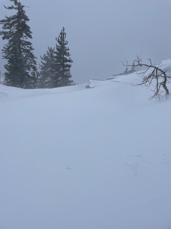
Insane. And California mountains were begging for snow much of the 2010s. The ebbs and flows of west/east.
-
1
-

March 2024 General Discussion
in Lakes/Ohio Valley
Posted
Dusting of snow this morning. 0.1" here and 0.3" DTW, but areas between Flint and the thumb got up to 2".
On this date last year, a scenic 5.2" snow fell, just 1 week after the 6.2" thundersnow storm.