

michsnowfreak
-
Posts
15,699 -
Joined
-
Last visited
Content Type
Profiles
Blogs
Forums
American Weather
Media Demo
Store
Gallery
Posts posted by michsnowfreak
-
-
5 hours ago, Lightning said:
Just using this list...
Worst in my life was => 11.) 20.0" - 1982-83. This winter was pure evil. To go for the record low and have it swiped out in the end.
Next would be => 20.) 25.1" - 1988-89. It was huge LES year. MTU neared the record; unfortunately it was one year to early for me.
Then comes => 18.) 23.7" - 1999-00. In general that winter just sucked. Interestingly it was sandwiched between to incredible periods events. January 99 & Nov./Dec. 2000
16.) 23.4" - 1997-98 => This winter was so overly forecasted to be warm that it didn't really bother me.
19.) 24.1" - 2003-04 => Detroit bad winter; not the norther burbs!!
Ones not on this list.
95-96 ... only saving grace was March!!
11-12 ... meh; very boring winter overall. Morch made for an interesting finish (but very bad for local fruit industry).
1999-00 & 2003-04 get a pass due to decent snowcover stretches
-
 1
1
-
 1
1
-
-
1 hour ago, TheClimateChanger said:
Same story in Toledo, less than an hour drive from DTW airport.
Of course, @michsnowfreaklikes to point out a 6.0" observation from the winter of 1889-1890, but I'm guessing that lacks daily resolution as it is not part of the threaded record, which begins in 1890-1891.
Toledo snowfall records began in 1885. They were always included until nws Cleveland randomly revamped their website and it now starts in 1890. There was no missing data, so the 6.0" figure is absolutely believable.
And actually, Toledo Express airport is a little bit over an hour drive from Detroit Metro airport, although I have absolutely no idea what Detroit has to do with Toledo. Especially as I have said many times the state-line snow cutoff the last 2 winters has been insane.
Not sure why we are using DTW as a drive time base, but Detroit Metro Airport (23.5") is a 65 minute drive to Toledo Express (9.6") airport but only a 25 minute drive to U of M Ann Arbor, where 36.9" has fallen this year.
-
1 hour ago, mississaugasnow said:
Coastal cities with 0-2” worst season can’t really talk about it until April haha
New York City saw just 0.5" in 1997-98 until a freak, unexpected snowstorm dropped 5.0" on March 22nd. It was gone in less than a day. But instead of ranking as least snowy winter, due to that unexpected spring storm, it "only" ranks as 8th least snowy.
-
1
-
-
1 hour ago, mississaugasnow said:
Yep, and to be fair you guys out west seem to have crazy low lowest snowfall. For example Ottawa is at 45” and it’s one of their least snowy winters ever
so if Ottawa is at 15” come mid January to early February it makes sense for them to start talking about futility
You guys out west I think you mentioned are 12”. So I see why talking about it early is pointless.
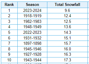
We have not had a sub-20" winter since 1969, but they did happen. Not frequently, but Detroits full top 20 lowest snowfall
01.) 12.9" - 1936-37
02.) 13.2" - 1881-82
03.) 13.7" - 1948-49
04.) 15.2" - 1918-19
05.) 15.4" - 1965-66
06.) 15.8" - 1889-90
07.) 16.6" - 1952-53
08.) 17.1" - 1968-69
09.) 18.0" - 1957-58
09.) 18.0" - 1960-61
11.) 20.0" - 1982-83
12.) 22.0" - 1945-46
13.) 22.6" - 1937-38
14.) 22.8" - 1943-44
15.) 23.2" - 1888-89
16.) 23.4" - 1941-42
16.) 23.4" - 1997-98
18.) 23.7" - 1999-00
19.) 24.1" - 2003-04
20.) 25.1" - 1988-89
Some late season facts about the above...they were terrible enough, but look where they could have been without....
#4) 1918-19: A heavy, wet snowstorm of 5.8" on Mar 9th, largest of the season, melted in 2 days, gave a big boost to the total
#6) 1889-90: A 5.0" heavy, wet snowstorm on March 29th was by far largest of the season
#9) 1960-61: Winters fiercest storm was its last - 3.0" fell at Detroit on April 16/17, but 4-5" fell in some suburbs and blizzard conditions clogged highways in west MI
#11) 1982-83: Disaster winter sees a late rally with a 7.3" snowstorm March 20/21 then another 3.4" snowfall April 17th
#13) 1937-38: 3 April snowfalls (4th, 6th, 8th) dropped a total of 3.9" at Detroit. The 4th dropped up to 4" well north of Detroit and the 6th dropped 6-7" near the Ohio border
#14) 1943-44: 15.7" of the seasons 22.8" fell after Feb 9th & 3.8" fell before November 16th,. So from Nov 17-Feb 9, a total of 3.3" fell.
#16) 1941-42: A 4.2" wet snowfall on April 9/10 would be the seasons largest
-
1
-
-
On 3/24/2024 at 1:25 PM, GaWx said:Per the link below that pertains to long term impact from the 2022 Tonga volcano, we may very well go right back to El Nino in 2025-6 and quite possibly a multi-year version. Note how the DJF temperature anomaly pattern over the US in figure 7a (which covers the progged peak period of effects 2025-2029 or the interval of 3-7 yrs after eruption) comes rather close to a typical El Niño, including the cool SE and mild NW. Also, note especially figure 11d, which shows an El Ninolike Pacific SSTa pattern:"The MiMA simulations confirm the robustness ofthe SWV-induced wave structure in the Pacific (Fig. 11ef),and they produce tropical surface temperature anomaliesconsistent with an El Ni˜no-like pattern (Fig. 11a-d). Thisheating is produced by the zonally asymmetric distributionof SWV in the tropics, and consistent with the increasedsurface downward longwave flux over the tropical Pacificin WACCM (Fig. 9a). Thus, it is possible that the SWVforcing from the eruption would favor a positive phase ofENSO on a multi-year timescale, but further work is re-quired to confirm this, in particular with a model includingfully interactive ocean and cloud feedbacks."So, @George001may very well be doing several years in a row of “how strong will El Niño get” starting with 2025-6 if this publication were to have a good clue.
Interesting in that those simulations seem to show much cooler summers than we have seen recently.
-
2 hours ago, mississaugasnow said:
Didnt come true in the eastern lakes for number 1 lol. Most of us on this side are going to be top 10 least snowy winter. Could a surprise April snowstorm happen and push some of us out of top 10 100%.
I believe heavily in stats so way below average by mid winter means starting to need a miracle to make a comeback. I guess in a sports analogy kind of way you might be the fan that never gives up until the end of the game haha. If my teams down 27-7 starting the 4th Im typically tossing the towel because chances of winning are down to 10% or less. Teams do come back and win 30-27 but it's pretty rare.
I totally respect everyone having their own opinion/twist on. Its just me personally, Ive seen so many times you get a bad stretch in Dec up to mid-Jan and the word "futility" (which I loosely think of as top 5) starts popping up, then we end up with average to above average snowfall.
And thats also why I say numbers are just one aspect of the story of a winter. Detroit is at 23.5", which is 18th least snowy winter, and just 0.7" would knock us down to #20 and 1.7" knock us out of the top 20, and thats easily doable. Doesnt mean it was an enjoyable winter at all, just means that quite a few winters saw less snow fall.
A look at this funky snow season at DTW - since 1880
October - 11th snowiest out of 144
November - 64th snowiest out of 144
December - 2nd least snowy out of 144
January - 27th snowiest out of 144
February - 20th least snowy out of 144
March - 12th least snowy out of 144
-
2
-
-
7 hours ago, OrdIowPitMsp said:
Quite a late season rally for Minneapolis. We’ve moved to 18th least snowy season all time and should be outside the top 20 after the deformation snows tomorrow.
25.6” season to date.
This is an excellent example of two of my weather beliefs:
1) Its WAY too early to even discuss the likelihood of season futility being achieved in the midwest/Lakes in Dec, Jan, or Feb, no matter how bad it has been.
2) Season total snowfall is just 1 metric of a winter for a true winter weenie. Doesnt always tell the entire story.
-
3
-
-
5 hours ago, Stebo said:
It did snow, and it wasn't in the teens for amounts. And that 2 week period was pretty good, plus it was mostly active we were just on the bad side of things too much.
Fair enough. The January stretch was excellent, so I'd probably lean closer to D than D-.
-
1 hour ago, mississaugasnow said:
Toronto is at 26” which is right now the 7th least snow season. Assuming we get about 2” more it would keep it right about top 10
The east end and a bit further north GTA is probably around 30” but no official airport measurements
Hamilton and west end GTA got wrecked this year. Top 5 worst snow season and sitting at 16” at Hamilton airport
The last few years the snow-rain line has been about 25 miles further south so GTA has been getting good winters but Rochester and them screwed. This year the rain snow line moved a bit further north so the city is now separated as the eastern suburbs doubled the western suburbs
Detroits northern suburbs hve a bit of a micro climate for heavier snowfall due to elevation. Particularly with LES & borderline events. Some years it's more influential than other years when you get a lot of borderline events. A great example would be this January 12th. The heart of the metro area got about 4-5 inches of 5:1 ratio snow, but the elevated northern suburbs got 8-9 inches with the same amount of liquid equivalent.
It would be great to have snow measurements from Detroit city Airport, but essentially that is nothing more than an unmanned asos, so the only actual reports to come out of Detroit proper since the late 1960s are spotter/coop reports. Since it juts east into the Lake/River, the city proper and northeast into SE macomb County is one of the worst spots in the area for snow overall, so DTW in the suburbs gets a little bit more (even though they are South and West of the city) and would be more representative of the area (probably why they became the official site in 1966). However, when you get a few events throughout a season where the city gets noticeably more (and Mar 22 is an extreme example), I would imagine DTW only averages a few inches more annually.
The last 2 winters have been very North to South oriented in the region. DTW has more than doubled Toledo's snowfall each of the last 2 winters, and detroit's northern suburbs have handily had more than DTW. Law of averages says big Ohio Winter probably coming within a few years.
-
3
-
-
52 minutes ago, Stebo said:
C- winter
Surprised that "generous" lol.
-
59 minutes ago, Stebo said:
Just some, I don't have the time here so I call in usually with big events. I do know we get shafted a lot tho comparatively.
My sister has lived in Saint Clair Shores for 10 years now and the number of times we get more snow than her far outnumbers times we get less (don't think I don't ask for updates in our group text every single snowfall
 ). But yesterday they got nailed. Seemed quite high ratio too. When I was out with my nephews, the snow in the shaded areas remained fluffy while in the sun it was great packing and rapidly melting.
-
8 minutes ago, LibertyBell said:
wow 2013-14 really stands out is this the snowiest winter on record there or was there any winter when Detroit hit 100"?
It's said NYC hit 100" just before records started being kept in the 1860s.
2013-14 is the snowiest on record! A local climatologist said when you combine everything together, it was easily the most severe winter on record for the area. The official tally was #1 snowiest and #8 coldest,m (plus the 4th coldest Nov-Mar on record) but when you factor in the wind and the high snow depths (snow depths were in the double digits for nearly the entire time early january through mid march) it is king.
Winters before the official record started always fascinate me because we have tidbits of information that we can piece together, but not enough to make us say for certain what happened. I have a couple books where people kept journals of the weather, so I'm trying to piece together ideas of how the Winters were. Needless to say, while it was a colder era overall, there were multiple mild "open" winters as well (Mild winters that were unusually bare of snow were always referred to as open winters back in the day). Your area in general is a bit more feast/famine than we are here in the lakes, so I'd think 100 inches would certainly seem possible If you could get a parade of noreasters & enough cold air.
-
1
-
-
18 minutes ago, LibertyBell said:
March 2012 for you guys was a lot like December 2015 for us.
Of note is that we got much colder after that and had a 30"+ snowstorm in January 2016 and even went below zero on Valentine's Day in February 2016.
And the winter before that we had a -10 anomaly for the entire month of February 2015 and a lot of snow from January thru March.
So many snowy winters starting from 2009-10 with 2011-12 being the rare exception dud winter.
Yes. December 2015 was very mild here too, however, when you add in the fact that your area is warmer to begin with, plus the higher departures, 2015 was absolutely more impressive on the East Coast. Meanwhile, March 2012 was bonkers here. And I don't care to ever repeat it. All it's doing is asking for imminent disaster to the fruit crops in the Great Lakes. Just 3 years later, we would see an equally impressive negative departure in february 2015.
Speaking of 2011-12, yes, it was a terrible snow season, but it was totally allowed considering the stretch it resided within.
The current 30 year average snowfall at Detroit is 45", but that is thanks in part to a number of very snowy winters in the 2000s/10s, as the long term average is closer to 41".
2007-08: 71.7"
2008-09: 65.7"
2009-10: 43.7"
2010-11: 69.1"
2011-12: 26.0"
2012-13: 47.7"
2013-14: 94.9"
2014-15: 47.5"
-
1
-
-
21 hours ago, cyclone77 said:
More than likely the seasonal snowfall total of 27.0" here will be the final total, as I don't see much chance going forward for additional snowfall.
68% of the season's snowfall fell within a 5-day period with 18.4" during that mid-January stretch.
Even though the total snowfall will end up being several inches below average the snowstorm on Jan 12th (13") made the winter. The extreme cold that immediately followed was icing on the cake. The rest of the winter was pretty benign from a winter storm tracking perspective, but at least we cashed in during the Jan stretch.
I guess I'd give this winter a B.
I would go D/D-. My lowest seasonal snowfall (21.3") in 29 years of records. A horrendous December and a bad Feb and March too. A terrible winter for snowcover. No 6"+ storms either, but we were kind of due for a winter without one as we have been racking them up, so might as well be during the train wreck of 2023-24.
All that said. I couldn't go F as many here seem to have hinted they would, for:
-Halloween snow. It was neat to see a dusting during trick or treat. My first measurable Oct snow since 2006.
-Nov 27 whiteout squall. It was legit near zero visibility for a few moments. I was on the road and could not a see a traffic light that was feet away.
-Jan 12 thundersnow was incredible. The 4.2" snowfall would be my largest event of the season, but would have been much greater if not for the 5-1 ratios.
-Jan 11-24: the 2 weeks that featured deep winter, the one true saving grace of the season. Snow fell nearly daily, multiple events, wind chills to -30, a brutal cold MLK day (hi/lo 9/-3), and a week of 5-7" snowpack was perfect for all outdoor winter fun.
-Feb 15- in and out like a summer storm, a deluge of snow came down for an hour and dropped 2".
-
1
-
1
-
-
7 hours ago, Stebo said:
Yeah we had 4" here in Eastpointe.
Do you keep track of daily snow in Eastpointe or just some events?
-
17 hours ago, mississaugasnow said:
@michsnowfreak. @SnowstormsTheres going to be some wild difference in snow totals across GTA
Pearson will end up middle ground. Looks like 6-10” east end. 4-6” Airport and 1-3” for my place and west end.
Hamilton and my place is now pretty much locked into seeing one of the worst winters snow wise ever.
Still up in the air with Pearson
If you're going to get screwed on a storm/cutoff, no better time than Spring. The snow just gets obliterated in the sun. Built an Easter snow bunny with my nephews at my sister's house, and despite the cold and dry air, sun is just killing the snow. Needless to say my half inch is gone. What's YYZ season? Are they the only station in Toronto that does snow?
DTW is at 23.5". If no more measurable snow falls, this would rank as the 18th least snowy winter. A terrible season regardless, but January January'd so that gave the middle finger to those wishing for true futility. Detroit city probably got about 5" to DTWs 0.5" yesterday, but the season would be a wash I'm sure, as DTW frequently gets more than the city, and I can confirm this in January. Detroit city has not had snow measurements in over 50 years.
In my 29 years of measuring snow in my backyard, this is only my 4th season in the 20s, and my lowest of the entire lot at 21.2". The previous low was 25.5" in 2011-12 & high 96.2" in 2013-14. Hoping year #30 is a good season next year!

-
2
-
-
19 hours ago, RogueWaves said:
Deedler's article stated that in his opinion, the depth likely peaked at 28" sometime in the early hours on the 5th or 6th, but then the SLP curved sharply north running up over KLAN (which didn't exist yet ofc), turning the snowstorm into a +RN event in Detroit dropping the depth by the time they took their official measurements at 7 am.
We will never know. But sounds like a good bet. I know in at least the 1930s-70s, the monthly logs would have the peak snow depth, not just the peak depth at obs time (if it happened to be deeper). But now it just goes by 7am, and probably the same back in 1900.
-
1
-
-
18 hours ago, mississaugasnow said:
Looks like you guys are starting to be due as well. That’s 15 years since you’ve seen one.
Yeah. Over the course of history, there have been a handful of really potent storms after mid March, but we really haven't had one in a while. But on the other hand, the number of 3-5" type snows past mid March, especially in April, has really been impressive in recent years.
-
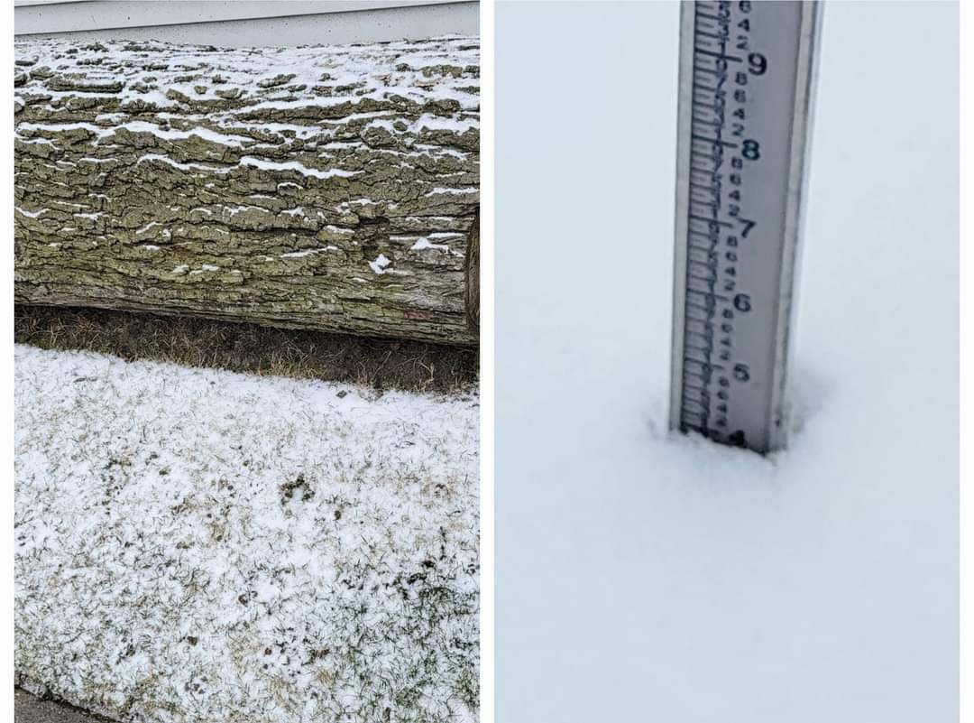
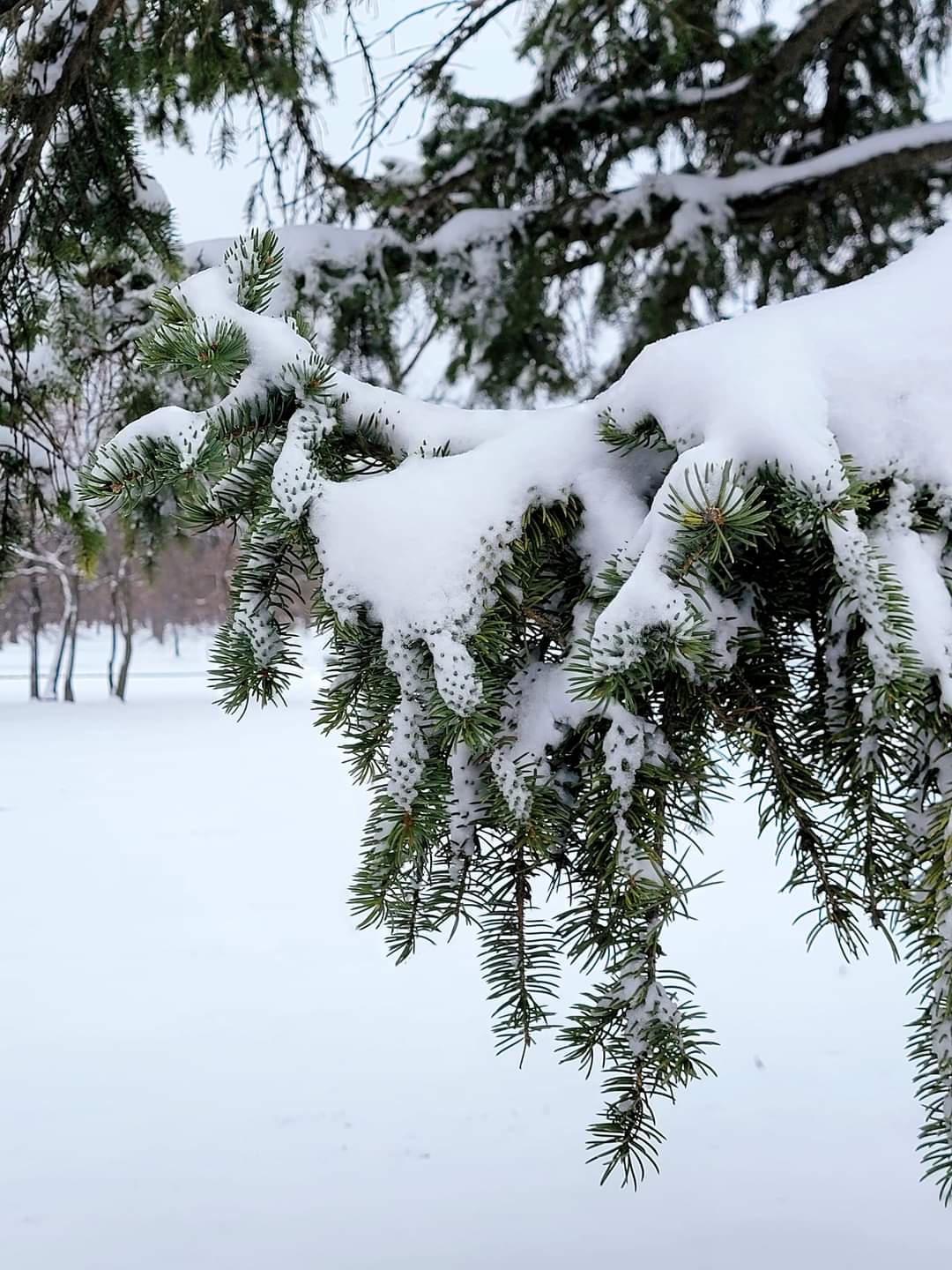
Razor sharp cutoff in wayne/washtenaw County. I received 0.4" (season to date 21.2") and DTW also received 0.4" (season to date 23.4"). Meanwhile northern parts of the County had a solid 4-5".
Drove 25-30 minutes to Belle Isle in Detroit and it was a mid-winter wonderland after just a dusting at home. Naturally I was pissed, but it would have been a thousand times worse if it was during winter. A lot easier to take in spring.
My sister lives on the lakeshore in southern macomb county (alek-esque), usually one of the worst spots for snow in SE MI but she was one of the jackpot areas with around 5". The irony is, her snow depth peaked in January at just 4" (when most of the metro was 6-8") so technically today was her deepest of the season.

My backyard (L) and Belle Isle (R), a mere 30 minute drive away.
-
5
-
-
16 minutes ago, Malacka11 said:
Isn't it largely due to melting/compaction?
I honestly have no clue.
-
1
-
-
1 hour ago, mississaugasnow said:
Thanks! Do you have some dates by chance. I enjoy looking to see what could have happened. Most are just bad luck. Buffalo and Detroit get 6.5” Toronto 4.9”
To the general public that’s not that big of a difference but to us it is haha
So not as many as I recalled. Quite a few in the 3-5" range but only 2 officially 6+ post Mar 15th since 2000.
7.2"- Apr 5/6, 2009
7.3"- Mar 21/22, 2008
I had an 8" storm Mar 25/26, 2002 where DTW only had 4.7" (huge cutoff).
-
1
-
-
1 hour ago, OrdIowPitMsp said:
P&C was bumped up to 4.1” imby for tonight’s event. NWS must think the heavier band will setup over the twin cities. We shall see.
P&C is at 17” for the Sunday/Monday storm. Shocked it’s that high tbh. Models have been trending more frozen precip today but given the complexity of the setup I think it’ll be a nowcast type of storm.
I've heard NWS mets frequently say not to add up the point and click, which I never understood lol
-
1 hour ago, mississaugasnow said:
If it can get to 6” or more it hasn’t happened in 20+ years this late in the season
currently looking at about 3-6” on most models
4” or more starts to become a once every 5 years or so after March 15th
So this storm if it can deliver is pretty rare for GTA
Certainly El Niño style end of winter
Wow weve has several in the last 20+ years. Good luck!
-
1
-
-
On 3/20/2024 at 2:45 PM, Brian D said:
As for Winter 2023/24, it's currently 3rd by the slimmest of margins behind 1931/32. 1931/32 (4.479) & 2023/24 (4.459*). Once all Feb data comes in, we'll see how that goes.
5 & 10 year trend charts shown respectively.
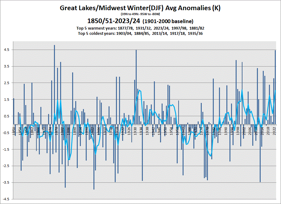
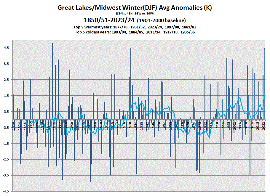
1931-32 was definitely warmer for the southern lakes and Midwest, but I think for the upper Midwest 2023-24 was a bit warmer.

March 2024 General Discussion
in Lakes/Ohio Valley
Posted
The reason I noted the airport is because I have a friend who lives in Toledo and each of the last 2 winters theyve had more than the airport to their south/west. Much less than DTW, but more than TOL, so Id estimate Toledo the city has probably had 12-15" this season. Monroe, MI is at 17". The last 2 years have been very latitude based in the region. I see Mansfield, OH is at just 8.4". Good Riddance El Nino.
And I know its xmacis. Xmacis doesnt always have all the data, it has to be input by someone lol. There is no reason that data that had been counted for 100+ years suddenly is not if there is no M data or anything. Im sure if it was a record that was to your liking youd 100% agree, seeing as though you frequently reference old data")