

michsnowfreak
-
Posts
17,110 -
Joined
-
Last visited
Content Type
Profiles
Blogs
Forums
American Weather
Media Demo
Store
Gallery
Posts posted by michsnowfreak
-
-
8 minutes ago, 40/70 Benchmark said:
This is what I am getting at with the inconsistency.....then why did NWS toss my total? The OCM reportd that it was tossed for using "the old school way" of measuring.
Its so inconsistent.
Wow thats definitely weird. I think just like in any other field, all NWS mets/employees are different and maybe the one you had had a soapbox or something. I assumed when you said they tossed it you just meant they didnt use it, but to actually note that "old school" thing is wild.
But inconsistency is the key word here. Regardless of what they do with coop/spotter reports, the official sites all clear every 6 hours. The OPL at DTX is awesome and friendly, Im going to ask her some time about the spotter stuff and see what her take or understanding on it is.
-
 1
1
-
-
21 minutes ago, LibertyBell said:
a snow bow or a moon bow are pretty rare! Do you have to be near the lake to see them?
Im not sure but probably has to have some sort of lake influence, because again, it has to do with just getting that sifting arctic powder falling in below zero air, which isnt really a synoptic feature, and the sky is otherwise mostly or partly clear. Picture when a powder snow is sitting on tree branches and the wind blows it off and it comes off in fine mists of powder/flakes. Its like that. Thats sort of what im trying to describe, and the sun hits it and makes a "snowbow" of colors. Ive seen it a few times but it isnt common.
-
1
-
-
56 minutes ago, 40/70 Benchmark said:
I have no doubt the 1888 blizzard was absolutely exceptional, but I defintely have some shred of doubt regarding a measurement of 44", ON THE LEVEL, at the end of the storm on the CT shore. That implies total snowfall of somewhere around 50"....tough to swallow.
I always thought when they said "on the level" it was implying that was the measurement, then they would notate the higher drifts. I definitely doubt some of the totals back then, but I always look at it as having some information is better than others.
I use 1900 as about the baseline for when I can really trust observations. The 1870s-1890s data is imo not perfect BUT is a great tool for us to piece together what each individual winter was like. Looking at the data here in Detroit for 1880-81 and 1881-82 is almost unbelievable in that 1880-81 was the most severe winter on record (until 2013-14 came along :)) and 1881-82 the warmest (still to this day). But the Laura Ingalls Wilder books (granted, this was in Dakota Territory I believe) detail this, one book being called "The Long Winter" which discusses the blizzard parade from Oct to Apr 1880-81, and the next book, while not concentrating on the weather as much references how warm and without snow 1881-82 was.
-
2
-
-
1 hour ago, 40/70 Benchmark said:
Yea, I'm not sure why, but I know that the NWS is now discouraging spotters from doing the swipe and clear method. I have all of the respect in the world for Chris and I'm not trying to be rude, but I deal with the NWS regularly and they defer to the lower depth measurements in larger events when theere is a noticeable contrast. It doesn't matter in 95% of the storms, but obviously it does in upper tier events.
Even the airports that do the 6 hour method are often not meticulous enough...they frequently underreport in mixed events because they measure after some has melted...its very common.
Thats another thing (bolded). The old days of weather observing showed extremely meticulous observations. Again, I have seen some of the old weather log books myself and they are incredible. Many days have a narrative that you will never see when just looking at the raw data (A narrative on Dec 25, 1901: Night of the 24 - 25 cloudy; moist snow continued, heaviest between hours of 1:30 and 4:30 am, ended at 6 am. amount of precipitation .62 inches. The street cars ran all night to keep the tracks open. The snow adhered to trees etc, and made a very beautiful scene. Depth of snow on ground at 8 am, 5.5 inches).
Fast forward to today, and you are talking everything is automated with exception of snow, and while most NWS offices work diligently to ensure they have good/well trained snow observers, they are subject to error like anyone else, and often are not actual NWS mets. So this acting like we have perfect measurements today and discounting old stuff is not silly.
And once again, Im not sure where this 1950-1980 stuff is coming from. Nearly ALL first order sites have followed the 6-hour rule since 1950 (spotters are another story).
-
2
-
-
2 hours ago, bluewave said:
Nothing compared to the under-measurement during the blizzard of 1888.
https://www.wunderground.com/cat6/US-Snowfall-1900-2019-Decade-Decade-Look
Another example: The great Blizzard of March 1888 brought Central Park 2.10” of melted precipitation, resulting in the official 21.0” snowfall reported. Since temperatures during the height of the blizzard were in the low teens, it is likely that the ratio was much greater than 10 to 1, and thus the actual snowfall considerably more than the 21.0” officially reported.
How does everyone know they didnt just measure snow and apply a 10-1 ratio, rather than the other way around? Ive seen old weather logs and they are incredibly detailed, but there is no reference to how or if they melted the snow. You are assuming that they melted it and applied a 10-1 ratio, yet they frequently would say there was "21" on the level with higher drifts" or something like that.
Though its been long since discounted, the original "rule of thumb" was 10" of snow holds 1" of water, so in the 1800s, it would be a hell of a lot easier to measure the snow with a ruler/yardstick and assume the 10-1 ratio, rather than not do the simple task of measuring it with a ruler but waiting around for hours if not a day for the snow to melt in a can indoors.
-
2
-
-
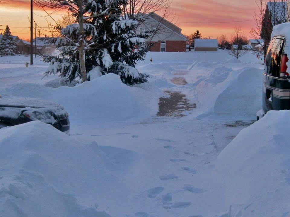
14 hours ago, LibertyBell said:
Wow, I love this sunset image. Have you ever seen pink snow? I have on two occasions-- January 2004 (sunrise) and February 2009 (sunset).
Heavy falling snow turns pink through a sunrise or sunset.
Sounds beautiful! I dont recall seeing that, though I have seen a snowbow and as said above, those brutal cold mornings it can be sifting glitter from a mostly blue sky, that is a sight to see and it glitters unlike any camera can capture, tho ive tried.
-
 1
1
-
-
13 hours ago, LibertyBell said:
You live in a great radiational cooling area, I'm envious. We only get cold air here via CAA.
Our temps closely match JFK.
I always wish i lived in a good radiational cooling area. I live blocks away from the Detroit River so the water kind of buffers my lows and makes them similar to DTW. But some of the radiational cooling spots in SE MI can really tank. The DTX NWS is a great example of this. It is a radiational cooling magnet in a rural area of Detroits far NW suburbs. They have data since 2000, so looking at the past 25 years of data, the average between there and DTW (Detroit Metro Apt) officially is very different.
Annual days at or below 0F: DTW- 3, DTX- 10
Annual days at or below 32F: DTW- 117, DTX- 150
First freeze avg: DTW- Oct 27th, DTX- Oct 8th
Last freeze avg: DTW- Apr 24th, DTX- May 12th
Radiational cooling is apparent all year long too. Even in the heat of summer, DTX NWS will fall into the 40s several times in July & August, whereas DTW typically does not see 40s in July or August.
-
1
-
-
Another cold morning. 25F at DTW, the frost this morning was very glittery. 5 of the first 9 days of April have had lows in the 20s at Detroit:
1st- 26
5th- 29
7th- 26
8th- 23
9th- 25
Last night some isolated but potent lake effect snow showers gave a coating to an inch around Port Huron.
-
53 minutes ago, nwohweather said:
Rough day to be at the Tigers game for sure
Game time temp was 34F. But Skubal pitched a masterpiece and Tigers won 5-0!
-
 1
1
-
-
2 hours ago, LibertyBell said:
That's very interesting, we used to have a lot of below zero temperatures right up to the 80s. Since then it's only been in 1994 and 2016 that it happened and that's it. We used to average a below zero temperature every other year, now it's like once a decade lol.
Some of the intense arctic shots have been concentrating more in the Plains/Midwest than the east coast. These arctic blasts typically are much colder to our west. The Great Lakes buffer the cold a bit, so in some of the biggest arctic blast we will see a "modification" of the air that often entails brisk winds and lake clouds and flakes, sometimes you get this fine arctic powder than just comes down and coats everything in glitter, despite nothing on radar, with temps being anywhere from 0F to -10F or so, whereas areas west of the lakes will be crystal clear and like -20 to -25F or something.
One thing that I notice is that the arctic airmasses are windier. I mean, you still get radiational cooling on clear, calm nights (esp with snowcover) but the temps dont tank as much in the metro area as they will in the rural areas. But these arctic blasts are almost always giving us below zero temps with gusty winds, creating brutal wind chills, and we usually get a quick one or two even in the milder winters. Since the much advertised "winter pattern shift" beginning in 2016, we have still seen -30F or colder wind chills in Jan 2019, Dec 2022, Jan 2024, & Jan 2025.
The coldest Ive felt was on Jan 6, 2014. It was about -14F with wind chills near -50F, and I took my gloves off to take this sunset pic and in the seconds I had my hands exposed they burned when I went inside. Not in my wildest dreams did I imagine that winter was only just beginning.
-
3
-
-
42 minutes ago, 40/70 Benchmark said:
Same here....and I don't know, but they are. measuring settled depth is an entirely different concept...its not "snowfall". Why I now do in large events is report both.....snowfall and settled depth, and the NWS can do with it as they wish.
Its a shame there isnt more consistence. I think the reason they probably dont have spotters do it is because most cant/wont. Some will, but others wont.
Again, here in a climate of more frequent but less dramatic snowfalls, Ive learned by far that the bigger the snowstorm the bigger the settling. I check the daily areas coop reports so I already know locally who is good and who is not. You can literally tell who actually measures properly and who measures whats on the board at their obs time. I have seen snowfalls that melted the day before actually go in as a trace, and thats ridiculous.
I know some of the DTX mets and Ive heard from others on this board who know some of their local NWS mets. Seems to me that the consensus is, the first order stations are called/call in for every obs (00z, 06z, 12z, 18z). Detroit and Flint have good observers, Saginaw is a bit more flighty. The NWS office is located in a very rural area far NW of Detroit. I wish they kept the NWS offices at the main first order site! If there is something fishy with a first order sites report, the met will usually question the observer (Ive heard this happens with CLE NWS for the Toledo observer).
I think/assume the general consensus with NWS offices is make sure your first order/main climate sites are coming in with proper/realistic measurments and as for your coops/spotters, just continue to post the "how to measure snow" guidelines on social media and hope for the best

-
1 minute ago, Stormchaserchuck1 said:
I mean the Earth is warming, but it was -32F in Valentine Nebraska a month ago, and it snowed 10" in Florida this year.. I don't think the "cold air is shrinking" is a valid theory besides general earth warming lol.
Agree. We have to separate the earth is warming from the winter cold availability. We go below zero and have had more impressive cold shots than we did locally in the 1930s-50s. Three different winters between 2014-19 saw temps get to -13F or colder at Detroit. That low (-13) was not attained once from 1935 til 1963.
-
1
-
-
35 minutes ago, 40/70 Benchmark said:
Absolutely agree with the underlined portion.
As for the last portion, you keep acting like this is standardized and it is not. The fact of the matter is that the predominate type of snowfall measurtement has moved away from the 6 hour swipe method with the exception of the major airports. The majority of spotters are not clearing and are discouraged from doing so. In March 2018, I had a 31.5" snowfall total discounted by the NWS because it was obtained but the 6 hour clear method...they accepted another report from that same town of 25", which was uncoincidentally was my final depth.
I always use the 6 hour method. However, im curious....why would spotters be discouraged from doing this? I didnt think most of them did it anyway. The 6-hour method is standard at all first order climate sites, but as for spotters, I always looked at them as volunteer weather observers who are volunteering their hobbyist observations; I take most spotter reports with a grain of salt whether its from 1910, 1960, or 2025 lol.
But again, this primarly affects the bigger storms.
-
4 minutes ago, LibertyBell said:
Thanks! I've also noticed they have problems with drier snow that happens in windy conditions so a lot of our big blizzards get undermeasured. We have several examples of this both more recently and in the distant past.
February 2003
January 1996
February 1978
February 1969
February 1961
March 1888
This is just an off the top of my head list, I'm sure there are many more.
Oh yes! Dry snow = bad for ASOS. Dry snow AND wind = nightmare for ASOS.
Its less of an issue with a standard rain gauge but still not fool proof.
-
 1
1
-
-
3 minutes ago, LibertyBell said:
The Mets game that was supposed to be tonight has been rescheduled for 1 PM today.
I've advocated for this for a long time now too. Like, in the spring and summer, if you know it's going to rain, why not schedule a game earlier? One of the most frustrating things about baseball is when you have an off day and the weather is nice and sunny and the next day it's going to rain and everyone knows it, and then you have two days off instead of just one. The game should be rescheduled earlier, to the off day the day before (if the other team also has that day off of course), instead of sitting around doing nothing for two days.
Its very frustrating for fans who had tickets tho. Its one of those things that will never make everyone happy. Its VERY tricky to schedule baseball based on a forecast tho. I have seen summer games where they delay the start due to a forecasted thunderstorm that never really hits the stadium area lol.
-
1
-
-
3 minutes ago, LibertyBell said:
This is something I've always advocated for, use precipitation totals to account for snowfall measuring errors. I would use a sliding scale snowfall to liquid ratio based on temperatures. 8:1 for heavier wet snow, 10:1 for normal snow and 15:1 for dry and fluffy snow.
I use a standard NWS rain gauge. So I do it the "old-fashioned" and fool proof way. Melt each snowfall. By doing this you will find that all snowfalls are different, although your sliding scale is an excellent base. Many ASOS have problems with drier snow, so you will see some slightly underdone totals which just baffles me that we have to deal with this in 2025, but it is what it is.
-
1
-
-
12 minutes ago, LibertyBell said:
Yes, I love fall baseball.... looks like the Tigers and Yankees will both be good enough to play deep into Fall.
We had some snow here on parts of Long Island before the sun came out, it really feels like winter here today with temperatures going below freezing tonight. It's the latest it's happened since 2014, when we had accumulating snow on April 16, 2014. We had snow on May 9, 2020 but the low was 34 on that date. Ironically our last freeze that season was in early March lol.
Spring of 2020. Oh boy lol. A 1.3" snowfall on Apr 15th was followed by 3.4" on Apr 17th. Then an unprecedented 5 days in a row of snow in May (May 8-12) which peaked as a half inch of wet snow on the 10th (Mothers Day).
-
1
-
-
38 minutes ago, bluewave said:
You can see what has been happening over the Pacific by looking at where the SSTs have been warming the fastest. The reason that we have been seeing more frequent La Ninas is due to the WPAC warming at a faster rate than the EPAC. So it causes stronger trade winds near the Dateline. This works against El Niño development. So when we finally tip the system back to El Niño it has to be very strong in order to develop against the very strong La Ninas background state. We saw the El Niño struggle to develop in 12-13 and 14-15 only to finally push through with the super El Niño in 15-16. Then again in 23-24.
But something shifted in the spring of 2023 with the record warming in the EPAC. This warming off the South American Coast is continuing into April 2025. So the La Niña this winter was among the weakest we have seen since 1950 coming off such a strong El Niño. The rapid increase in global warming last 2 years may suggest that we have experienced a new type of Pacific shift. One in which the system is tilted more to El Niño development. If the EPAC warming persists into the summer, then it may inhibit the typical 2nd year La Ninas which has been the norm recently. So if any type of El Niño can push through from 25-26 to 26-27, then we me be in uncharted territory. But we will need more data going forward to confirm this new hypothesis.
Ultimately, we will need to see a shift in the record Northern Stream of the Pacific Jet since 18-19 with the lowest cumulative 7 year snowfall on record from Philly to Boston for any snowfall improvement. This is very uncertain since the competing marine heatwaves in the North Pacific blur the distinctions between what we expect from a -PDO and +PDO. The next 5-7 years will probably be make or break as to whether this snowfall regime since 18-19 is a new climate feature or something that can shift a bit going forward.
Long term we expect snowfall to decrease as the climate and the storm tracks warm. So using a linear understanding of the climate we could say that we get years of ups and others with more downs as the general trend line on snowfall is down. But if we see more of a non linear shift with the snow, then the decline could occur faster than then a general decrease along a linear path. Since snowfall measurement methodology shifted since the 1980s. From late 1800s into mid 1900s snowfall was under measured by today’s standards. So when the snowfall record is corrected higher from 1880 to 1980 or so, most areas will show a steady decline away from the Great Lakes snow belts with more frequent measurements these days than in the old days inflating the present totals.
30 minutes ago, LibertyBell said:So late 1800s into mid 1900s snowfall was under measured by today’s standards.
This is absolutely amazing because we were already averaging around 35" of snow per decade from the 1860s through the 1910s..... so this may actually have been over 40" And the decades before the 1860s were even snowier!
This "snow being undermeasured" in the old days is widely skeptical IMO. Its just another excuse for some to try and find an excuse for the weaker winters of the old days, and assume the snowier winters were even snowier. Whether its 1880 or 2025, snow is measured by a human and subject to human error.
For starters, nearly all first order stations have used the same 6-hour snow measurement practices since 1950 or so, not 1980.
As for pre-1950 data, a key I look for is precip total, snowfall, and snow depth. This is where you would notice any inflations or undermeasurments. One thing working in their favor in the pre-1950 years vs today is that the weather obs were highly cared for and someone was monitoring around the clock. With most first order sites now away from the actual NWS (weather bureau in the old days), you rely on the observers to be on top of things if anything like melting, mixing, etc occurred between the 6 hour intervals. In the old days they were on top of all that, documenting every detail (ie: snow began at 7:38pm, or snow ended at 3:42pm). If one truly measured only at the end of a storm or whatever, you would find that it is mostly the larger storms that are more inflated using 6 hours.
The main data I question locally is the 1870s-1890s data. Far too often they always used the 10-1 ratio. If I had to guess, what I THINK they did was measure the snow depth "on the level" and apply a 10-1 ratio. Once we get to 1900 or so is when the data becomes more clear (ie, its not always 10-1 ratio, the snow depth is more in line with compacting/settling, etc).
In my spare time Im working on piecing together weather data from the 1830s-1860s. I have several journals/books that detail it, so Im trying to piece together the good and not so good years. As I understand it, the 1860s were generally harsh winters, the 1850s a mixed bag, and the 1830s-1840s were quite mild and "open" winters with a few exceptions. So dont just assume any linear up or down at any level.
Last but certainly not least, in terms of future snow...dont assume warmer means less snow for all. While it may be the case for NYC and south, for places farther north it could be a completely different story. Milder winters often lead to more dynamic/powerful snowstorms in further north climes.
-
1
-
1
-
1
-
-
16 hours ago, LibertyBell said:
Early April is too early for baseball let alone late March which is when baseball begins now.
This years Tigers home opener had a game time temp of 50F, which was the warmest home opener in 10 years. Games 2 and 3 were mid-40s then yesterdays game time temp was 38F. Todays will be in the 30s somewhere (it was 23F this morning!).
Sitting in the cold during April games is quite uncomfortable, even for a winter lover. When the chill of Fall hits for Sept and especially Oct baseball, its a complete different story. There nothing like the crisp, chilly autumn air swirling around the smells of the ballpark during playoff baseball! Of course its not quite as cold as April, but the difference is the April cold comes after a long winter when youre body is used to cold, whereas Fall baseball comes after a hot summer. Yet it hits so differently.
-
1
-
-
DTW got down to 23F this morning with wind chills near 10F. A few more flurries overnight. Definitely feels like winter.
-
1 minute ago, LibertyBell said:
I noticed the change in timing! Are the other two games going to have snow too (or was that forecast to happen at night?)
They changed due to cold, not snow. Lows tonight and tomorrow night in the low 20s with wind chills tonight in the teens. The decision to move up was because it's "warmer" in the day. Tomorrow should have sun but high only 37, maybe some lake snow showers. Wed will be warmer but rain and snow possible at night.
Just sucks for whoever had tickets to night games.
-
1
-
-
13 minutes ago, LibertyBell said:
anyone who wants to see snow just needs to watch the Yankees at Tigers game!!
Big cold front came thru. Its windy and the flakes are flying off and on. Wind chills in the teens later. They changed all 3 games to day games this series because of the cold.

-
1
-
-
If I had to pick between a nino and nina, its nina all day everyday here so Im fine with them being more frequent. That said, ENSO episodes have proven multiple times the past few decades that they dont always behave according to expectation.
It does seem that ninos and ninas are kind of suffocating "neutral" years and making them few and far between.
-
Snowing at the Tigers game
-
3
-
2025-2026 ENSO
in Weather Forecasting and Discussion
Posted
This is just another example of how all observers are different and you cant make blanket assumptions about past or present.