

CentralNC
-
Posts
770 -
Joined
-
Last visited
Content Type
Profiles
Blogs
Forums
American Weather
Media Demo
Store
Gallery
Everything posted by CentralNC
-
Buhleedat!
-
Raleigh definitely buying the warm nose. Hard to deny it happening. .LONG TERM /SATURDAY THROUGH THURSDAY/... As of 330 PM Thursday... ...Potentially Hazardous Wintry Precipitation Remains on Track for the End of the Weekend... Surface high pressure will build from the just north of the Great Lakes Region on Saturday towards New England Saturday night. This cold high will create cloudy and cold conditions across the region as a CAD sets up, with highs only in the mid-30s north to mid 40s south. The upper-level low currently moving across the PAC NW will dig southeast towards the Deep South by Sunday morning, and lift northeast across the Appalachians through early Monday. Additionally, surface low pressure will strengthen across the Deep South on Saturday, then move northeast across the Blue Ridge Sunday, while strengthening another low that develops near the eastern half of NC in a "Miller B" scenario. A few showers may develop across the western Piedmont Saturday evening, then widespread precipitation will spread across the region Saturday night through early Sunday night. Models are coming into better agreement with the details, and confidence is increasing that this will be less of a snow event and more of a freezing rain/rain event. All areas will be below zero when precipitation begins to fall Saturday night, and most areas north of the Sandhills and southern Piedmont will likely see snow where it develops, while southern areas have a rain/snow mix. Then by early Sunday morning, a warm nose develops as the the possibility of freezing rain/sleet spreads north to just south of the Triangle by noon. By late Sunday afternoon, areas away from the Triad will likely have rain, while freezing rain becomes the dominant precipitation type across the northwest. This warm nose will lower snowfall amounts across most areas, even the Triad. Accumulating ice will become the greater hazard in the afternoon, and with wind gusts around 25 mph, could easily break weak icy tree branches. A dry slot will likely cut off moisture and end precipitation quickly late Sunday evening into early Sunday night. A Winter Storm Watch may be issued for portions of central NC either tonight or Friday morning. Highs Sunday will range from near 30 far NW to near 50 far SE. Surface high pressure then builds across the SE for early to mid next week, with highs rising to the mid 40s to mid 50s by Wednesday. The next chance of precipitation will be late Wednesday into Thursday as a surface cold front pushes across the region and an upper-level shortwave moves in from the east.
-
GSP going with WSW for entire CWA
-
NAM for the win?
-
Hunch says Triad, but they can't both get clobbered. See 1/22/1987 storm
-
Welcome back. Note: most are still addicted to colorful snow maps.
-
But also want to add that **someone** will end up with severe ZR out of this it does appear. Won't know until Sat. at the earliest.
-
Thanks for adding that. Most of the "devestating" ice storm maps end up being mostly sleet. Even 2002 had front end thump snow and then totally IP in my neck of the woods.
-
I would normally agree with you but I have a pretty good feeling about this one.
-
Still early in the game.
-
Snowing in Lewisville. 39 degrees
-
Can I help you pack?
-
Don't do this to yourself.
-
I think it's on to next winter. It just ain't happenin this year. Hopefully we have all learned a lesson about these models this year.
-
I LIKE that!
-
Yes but don't put MAJOR in the title!
-
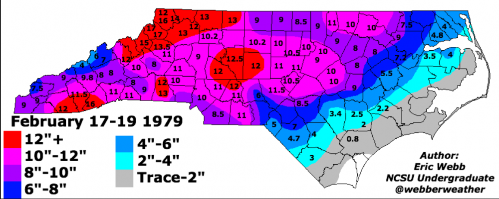
On this date in 1979, one of my favorite storms. You want cold air? Snow started right before dawn and temps fell from the low 20's to the low teens by early afternoon. Some blowing and drifting. Of course this is known as PD1 and it was spectacular. Watched from my dorm room in Salisbury in complete awe.
-
Don't feel bad. Most on this forum were..
-
Oh no, we suck again
-

February 18-19 MAJOR Ice Storm Threat
CentralNC replied to NorthHillsWx's topic in Southeastern States
32 still with ZR/IP mix. Definitely more than last weekend thus far. Trees droopy but not too bad -
February 18-19 MAJOR Ice Storm Threat
CentralNC replied to NorthHillsWx's topic in Southeastern States
32 with ZR. At this point we have about as much glaze as we ended with last weekend. Looks like a couple more hours of it (perhaps). Not going to be devastating here by any stretch. -
February 18-19 MAJOR Ice Storm Threat
CentralNC replied to NorthHillsWx's topic in Southeastern States
Bustogenesis in process. -
February 18-19 MAJOR Ice Storm Threat
CentralNC replied to NorthHillsWx's topic in Southeastern States
Yep, pretty clear to me that heaviest ice totals will be in VA border counties unless I am missing something. -
February 18-19 MAJOR Ice Storm Threat
CentralNC replied to NorthHillsWx's topic in Southeastern States
The way most of these work out is there is a fairly narrow strip where the WORST of the icing is. Widespread .50 ice and up is hard to achieve. That strip is to be determined but based on precip trends, I would say NW piedmont and northern foothills of NC if I was a bettin man. -
February 18-19 MAJOR Ice Storm Threat
CentralNC replied to NorthHillsWx's topic in Southeastern States
Thanks Matt. Going to be a rough situation for a bunch of north carolinians.


