

CentralNC
-
Posts
770 -
Joined
-
Last visited
Content Type
Profiles
Blogs
Forums
American Weather
Media Demo
Store
Gallery
Everything posted by CentralNC
-
Let's hope so. I have no measurable rain at my house this month.
-
Hope so. Really bad at my location. It has rained some within 5 miles of the house, but ZERO rain here for all of June. NADA. Nobody mowing grass around me at all.
-
Yeah, I know. Super jealous.
-
No doubt. I was a little hopeful, but am slowly learning to basically ignore any rain threats coming from the NW. They simply don't make it past the Yadkin river.
-
Meanwhile, in Forsyth county, nada last evening/night.
-
Models, as usual, overdoing the precip totals. Same was in winter..
-
Not even enough here to get it wet under the trees.
-
We had measurable snow feb 4-5 in the Triad but know what you're saying
-

Anyone having trouble paying the subscription?
CentralNC replied to MN Transplant's topic in Forum Information & Help
Yes, I have tried every card I have and sent a message in the support link but nobody ever answered me. I have tried multiple browsers as well. -
My son works in Winston and told me pretty solid light snow there on Stratford road. Tons of wrecks in Forsyth County
-
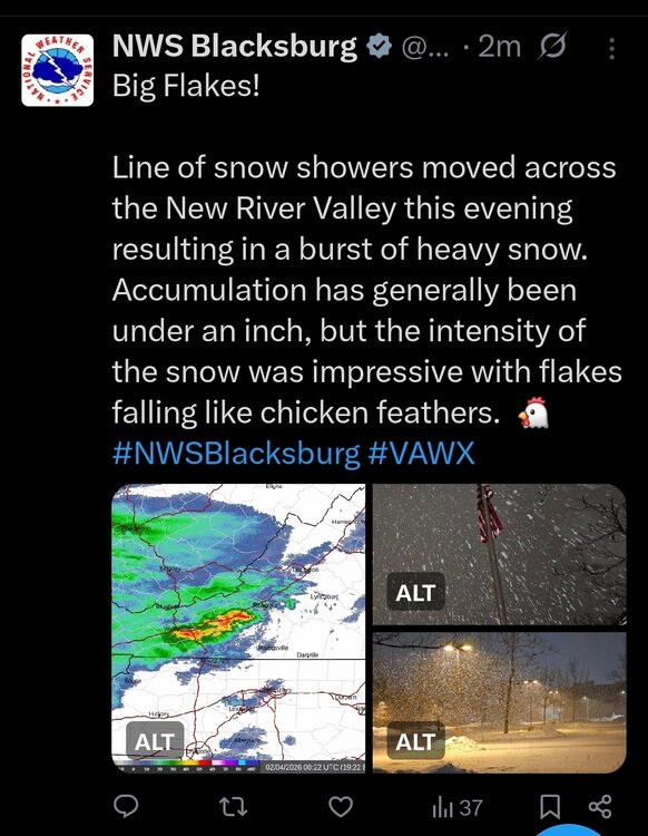
Chicken feathers...had not heard that one
-
Oh I know what you were saying. But the complaining around Lewisville on FB and otherwise is entertaining (sometimes depressing). Do they not teach that ice does not melt until it reaches 32 degrees anymore? People don't seem to trust that science or understand it.
-
Dang you sounds like my Lewisville peeps! Never heard so much bitchin
-
Euro always latches onto the big ones
-
I don't know why the term "bomb cyclone" bothers me so much....but it just does.
-
January 30th- Feb 1st ULL and coastal storm obs
CentralNC replied to JoshM's topic in Southeastern States
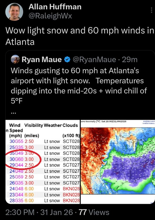
ATL wind gusts to 63 at 5pm!! CITY SKY/WX TMP DP RH WIND PRES REMARKS ATLANTA PTSUNNY 24 6 46 NW33G63 30.06R WCI 6 TC -4 -
January 30th- Feb 1st ULL and coastal storm obs
CentralNC replied to JoshM's topic in Southeastern States
-
January 30th- Feb 1st ULL and coastal storm obs
CentralNC replied to JoshM's topic in Southeastern States
Solid 5 inches in Lewisville/Clemmons area at 2:15. Still moderate snow and 19 degrees -
January 30th- Feb 1st ULL and coastal storm obs
CentralNC replied to JoshM's topic in Southeastern States
Looks like Greensboro to Asheboro corridor getting absolutely smoked right now -
January 30th- Feb 1st ULL and coastal storm obs
CentralNC replied to JoshM's topic in Southeastern States
0Z GFS has an unbelievable blizzard here at that time. 6Z backed off. Fantasy land but you can see this pattern can produce extremes. Our threats are not over by a long shot. -
January 30th- Feb 1st ULL and coastal storm obs
CentralNC replied to JoshM's topic in Southeastern States
I mean it is snowing but those returns don't match ground truth. Very light snow here. Weird because at 4am it was pretty heavy and Radar showed very little. Odd -
January 30th- Feb 1st ULL and coastal storm obs
CentralNC replied to JoshM's topic in Southeastern States
Not in Lewisville. Barely a flurry currently at 9:20 -
The “I bring the mojo” Jan 30-Feb 1 potential winter storm
CentralNC replied to lilj4425's topic in Southeastern States
Yeah I think Raleigh folks have to hope the coastal throws them some bones. Not looking too good there. -
January 30th- Feb 1st ULL and coastal storm obs
CentralNC replied to JoshM's topic in Southeastern States
23 and light snow in Lewisville/Clemmons. Really picked up in the last 10 minutes. Approaching 1/2 inch. -
January 30th- Feb 1st ULL and coastal storm obs
CentralNC replied to JoshM's topic in Southeastern States
Light snow and 24 degrees in Lewisville/Clemmons


