CentralNC
-
Posts
770 -
Joined
-
Last visited
Content Type
Profiles
Blogs
Forums
American Weather
Media Demo
Store
Gallery
Everything posted by CentralNC
-
Managed to make it to 20 this morning
-

1/10-11 super awesome winter SE OBS thread
CentralNC replied to strongwxnc's topic in Southeastern States
Final tally in Lewisville was 2 inches. 25 degrees and starry skies. -
1/10-11 super awesome winter SE OBS thread
CentralNC replied to strongwxnc's topic in Southeastern States
Very intrigued by that final band back in the foothills racing NE... -
1/10-11 super awesome winter SE OBS thread
CentralNC replied to strongwxnc's topic in Southeastern States
Moderate snow in Lewisville - even though radar looks like trash. -
Moderate snow in Lewisville now after an hour of sleet.
-
1/10-11 super awesome winter SE OBS thread
CentralNC replied to strongwxnc's topic in Southeastern States
Somebody mentioned "gold dust" earlier? We've got it now! Sleet seems to be over -
1/10-11 super awesome winter SE OBS thread
CentralNC replied to strongwxnc's topic in Southeastern States
Sleet in Lewisville. Impossible to have big snowstorms in the Piedmont with S or SW surface winds -
1/10-11 super awesome winter SE OBS thread
CentralNC replied to strongwxnc's topic in Southeastern States
Snow picking up in Lewisville. 28 degrees and we have about an inch -
1/10-11 super awesome winter SE OBS thread
CentralNC replied to strongwxnc's topic in Southeastern States
We used to have a lot of Hickory posters. Anyone know the ground truth there? -
It's just kind of a weak one and going pretty much straight out into the Atlantic, so no big deepener that climbs the coast.
-
1/10-11 super awesome winter SE OBS thread
CentralNC replied to strongwxnc's topic in Southeastern States
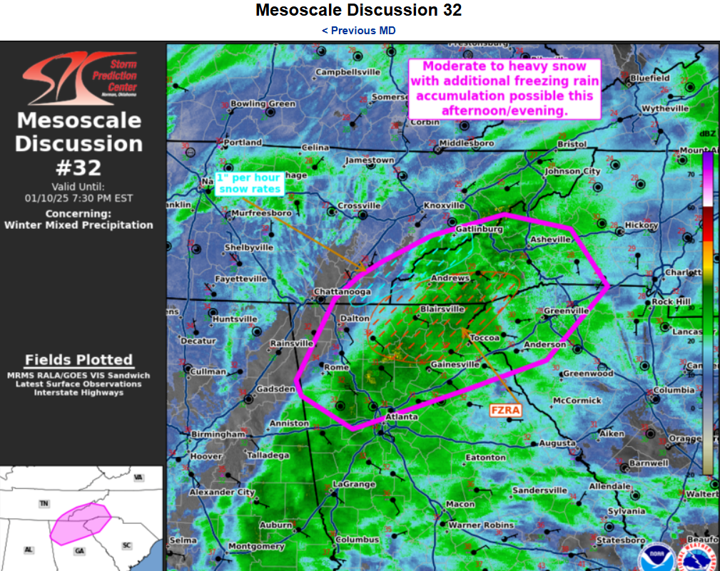
Mesoscale Discussion 0032 NWS Storm Prediction Center Norman OK 0330 PM CST Fri Jan 10 2025 Areas affected...northern Georgia...eastern Tennessee...far western South Carolina...western North Carolina Concerning...Winter mixed precipitation Valid 102130Z - 110030Z SUMMARY...Areas of moderate to heavy snowfall along the high terrain and mixed precipitation likely in the afternoon/evening across portions of east TN/north GA and western SC/NC. DISCUSSION...A broad region of heavy precipitation continues to shift northward across northern Alabama into eastern Tennessee/northern Georgia beneath enhanced mid-level flow and forcing from an upper-level trough. This precipitation shield will continue to lift north and eastward this evening, bringing an increase in the precipitation rates across the region, extending into western North Carolina through time. Moderate to heavy snowfall will be possible (with occasional 1" hr rates) across the southern Appalachian Mountains in eastern Tennessee. Further south across northern Georgia into the western Carolinas, profiles will continue to support additional accumulations of freezing rain. NAM/RAP sounding analysis across northern Georgia into South Carolina show a warm nose at 850 mb with surface observations indicating temperatures remain in the upper 20s to 30s. Occasionally, mixed precipitation/sleet will be possible.
-
1/10-11 super awesome winter SE OBS thread
CentralNC replied to strongwxnc's topic in Southeastern States
The Calvary hits Hickory and dies...
-
We had a great first burst, but now in the same hole as Hickory. Sometimes the calvary never arrives.
-
Same here
-
1/10-11 super awesome winter SE OBS thread
CentralNC replied to strongwxnc's topic in Southeastern States
Noticed the same thing. I don't think the lull will last to long. -
1/10-11 super awesome winter SE OBS thread
CentralNC replied to strongwxnc's topic in Southeastern States
Moderate snow and 28 degrees. Dropped 3 degrees in 45 minutes once it started. -
1/10-11 super awesome winter SE OBS thread
CentralNC replied to strongwxnc's topic in Southeastern States
Light snow in Lewisville. 31 degrees -
One look at this makes us understand while Raleigh folks are always nervous.
-
Most definitely.
-
1/10-11 super awesome winter SE OBS thread
CentralNC replied to strongwxnc's topic in Southeastern States
24 and cloudy. -
They all look to be true on this one as well.
-
Thanks for the update!
-
Do we need an OBs thread just for this storm or just report Obs in the regular thread for January?
-
Should be a good call
-
Good write up by WPC on Heavy Snow discussion https://www.wpc.ncep.noaa.gov/discussions/hpcdiscussions.php?disc=qpfhsd