

nrgjeff
-
Posts
4,197 -
Joined
-
Last visited
Content Type
Profiles
Blogs
Forums
American Weather
Media Demo
Store
Gallery
Everything posted by nrgjeff
-

Central/Western Medium-Long Range Discussion
nrgjeff replied to andyhb's topic in Central/Western States
Sunday and Monday looks like plenty of CAPE. What about turning with height? What makes the composite parameter soar? Is it CAPE without good turning? Is it turning on a warm front with cloudy stable stratoform rain? Obviously the former is much more likely than the latter this case (CAPE chart previous page); however, the latter happens often early season. For legit severe we need both juxtaposed. Is turning with height forecast? Let's take a look at the Central Plains both Sunday and Monday on the ECMWF. At 250 mb winds are seasonable (modest but not dead) from the WSW. At 500 mb a short-wave passes Sunday but winds weaken Monday. Both days 500 mb is WNW. Despite AN heights, 700 mb is not too hot. 700 mb wind is also from the WNW. Sunday and Monday 850 mb is straight south (good) but modest. Surface and 925 mb are from the southeast. So, we have great turning with height from surface to 700 mb. Winds are not too strong however. Pretty sure not tornado outbreak. Actually this is what late season chasers seek. Keep it subtle. Avoid crowds. Maybe find an isolated gem. Veer back is forecast from 500 mb to 250 mb; however, that high up is not a deal killer. It's especially OK late-season vs early. I've already taken my chase trip and found what we sought last week. I think the weather pattern looks good for those out there late-season and/or still looking for their tornado; but, it is not good enough to justify another trip after seeing a two-cycle tornado event last week. Who knows? Maybe a CO/WY gem could happen in upslope flow. Best to check all constant pressure level forecast charts in the extended. Forecast soundings are worthless past 36 hours, esp if convection contaminates. Constant pressure level forecasts are OK a few days out to discern forecast turning with height (or not). At the very least, check both CAPE and Helicity forecasts separately for juxtaposition. The latter forecasts turning with height, but even it can mislead if speed overwhelms no turning. Composite parameters are not that useful. So, drilling down (or up) the constant pressure charts is best. -
Central/Western Medium-Long Range Discussion
nrgjeff replied to andyhb's topic in Central/Western States
Chasers rejoice; the GL trough is even weaker and less important now! Friday it now appears ample moisture will be up on the dry line. Low level winds are backed a bit. Uppers are SSW to SW, and probably enough turning with height. Saturday remains TBD based on mesoscale factors. Upper winds get a little meridional in the Plains. However if an outflow gets down to Texas, winds show more turning upstairs on the ECMWF. I'm not sure whether to hope for that though. Texas tends to be messy. Sunday could be a break. Might need a rest and or reposition day. Monday through Wednesday I figure two more chase days. I doubt all 3, but who knows. Looks like another trough comes out Monday; placement is TBD between Iowa and Kansas. Tuesday or Wednesday looks like another. Models still sorting out which, and there is a slight chance all 3 days go. -
Central/Western Medium-Long Range Discussion
nrgjeff replied to andyhb's topic in Central/Western States
Indeed SPC started with Friday (Sunday Day 4-8). Looks like they left Saturday for post-MCS meso-scale details. Friday could be more active up on the WF. I'm afraid dews are not high enough on the DL; but, anything can happen on the High Plains. More importantly, it appears we have reeled in the weeklies and ensembles into the Day 5-7 forecast. That's an accomplishment compared to the last few years. Remember the epic flip last year? A perfect pattern out weeks 3-4 turned into trash by week 2. Not this year! Complex signals add confidence to model forecasts. Pacific jet extension will set the table. Then a +AAO and -NAO combo this time of year actually helps keep a west trough and systems going through the Plains. NAO is not the same animal as back in April. +AAO helps avoid that awful GL trough no longer progged. Boundary layer moisture has improved the last few runs, not a surprise really. This weekend should be just the start of an active 7-10 day period, perhaps as long as two weeks. It's on! -
Slight goes up the Mississippi Alabama line almost to Tenn. 2% strong! Just kidding. The Plains beckons in a week. Locally we do have outflow lifting through MS/AL. Thunderstorms are in progress from west Mississippi. Looks sloppy without any new development. However they are on or close to that boundary.
-
TN valley heavy rain/flooding week of whenever
nrgjeff replied to janetjanet998's topic in Tennessee Valley
ECMWF comes out after the Day 2 from SPC. Evidence now supports a slight risk Saturday from North Alabama into North Georgia. NAM and Euro both have a lot of CAPE along and south of a lifting boundary. I thought the 12Z NAM was nuts showing a right mover there; other CAMs do not. Now.. Euro introduces a mesolow on the said boundary. Low level winds are veered off, and the upper levels are not robust. However it's May which is CAPE season. While the Day 2 update is still Marginal, I figure on waking up to Slight. No I'm not staying up, lol! Something to watch Saturday though. -
Central/Western Medium-Long Range Discussion
nrgjeff replied to andyhb's topic in Central/Western States
The period from May 17/18-ish for 7-10 days looks very active in the Plains. This 500 mb chart forecast is accompanied by strengthening upper level jet stream from the WSW and LLJ response most days from the straight south. Tee. It. Up!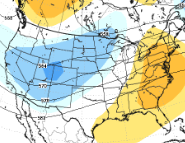
-
Thursday morning: Slight kink in surface wind trajectories is noted on the TN/KY border. Boundary occasionally shows on visible satellite. However both sides are pretty veered off. MCV is approaching so I expect the Slight verifies for mainly wind. Deep layer shear is meh. However low level shear is OK, esp on the boundary and straight east of the MCV. Probably not a big deal, but it's something to talk about in our Region. Otherwise I think the seasonal progression toward the Plains is on-track. They had quite a week!
-
Let's forget about snow this winter, and just have Dixie Alley going for 6 months straight.
-
Central/Western Medium-Long Range Discussion
nrgjeff replied to andyhb's topic in Central/Western States
ECMWF verbatim May 4 will be Bennington 4.0 but it's Day 10. EPS and GFS keep the train rolling in the 11-15 day. Weekly models (no skill after week 3) have more action the rest of May. MJO and AAM trends are forecast to be friendly. We'll see. One example of nice real data is Japan's Himawari satellite loop. West Pac convection is starting to lose influence as the Indian Ocean flares up. Buffet line of mid-latitude systems is noted from East Asia across the Pacific Ocean. -
Central/Western Medium-Long Range Discussion
nrgjeff replied to andyhb's topic in Central/Western States
Next 7-10 days will struggle. GOM trajectories point to the Caribbean, not the Mainland. That's a problem! Could perk up a bit 11-15 day period. More troughing is forecast out West. Going into May moisture will be more predicable too. MJO is trying to improve. Indian Ocean is waking up. Still junk in the West Pac though. Some models rush the latter through and reset toward week 3. Others let the IO start to influence sooner. Either way I can't argue with climo. Should pick up by mid-May. -
I'm far less optimistic than the Twitterverse. While the IO is flaring up as expected, the West Pac remains active too. Signal conflict. Expect mixed outcome in the USA. I'm pretty bearish next 15-20 days. Perhaps it switches around for late may peak of climo. I ain't holding my breath. It'd be Plains anyway. ECMWF weeklies flipped from good to poor about next week a year ago. I'm expecting a repeat. Sorry I am so jaded. Too much early season VBV garbage.
-
Another year without snow in CHA. Farther west the Plains and Mid South cash in.
-
TNI is backwards. Cancel rest of severe season. Today is a great example of crap setups.
-
Glad nobody started a thread. Today does not deserve one. My first day back since Sunday.. HRRR seems odd with heavy stratoform precip. NAM tries to fire off the back side of line later this evening. LOL at that solution with LLJ cut off and stable atmo. Line may spit out some straight wind later this afternoon; then, weakens. South Bama could keep going. Spann may have a long night. Up here I'm not too concerned. Looking fwd to watching more NBA playoffs.
-
Saturday it now appears supercells will make it east to the Delta (flat no trees) of east Louisiana and southeast Arkansas during daylight hours. Euro/NAM have a slow bias and even they put it in range. GFS and ARW (research version of WRF) has always rocked the Delta. SPC seems to agree. Detailed discussion is in a Central/West thread.
-
Event thread for April 13-14 weekend severe wx outbreak is in Central/West. Thread subtitle includes Mississippi, my likely chase target Saturday. My thoughts are in that thread. Basically with less morning rain in Mississippi, the warm front should lift north more. I expect discrete cells along the WF and/or outflow boundaries.
-
SPC 30% looks good for MS/AL Saturday. Winds turn with height gradually which creates rather classic forecast hodographs. Low level turning is notable. Instability will rapidly increase as the warm front lifts north. Storm mode will be sloppy along the pre-frontal trough. However discrete supercells could/should develop along the WF in LA/MS/AL. Overnight Saturday night looks ugly on the ECMWF. Holds supercells, almost a line of pearls, overnight. Much as I like storms and chasing, I'm rooting against that overnight crap.
-
Palm Sunday is the elephant in the room, so I'll address it. It's Day 7. Done. OK seriously, the GFS verbatim only shows ENH due to unidirectional winds, lots of rain, and likely coastal MCS. ECMWF verbatim is MDT no sugar coating it. However neither are high, thanks to moisture concerns, and possibly energy ejecting too far north. Still Day 7 so lots can change. Might end up Marginal, lol. Ways to get there include heavy rain on unidirectional winds or some sort of Gulf MCS. Little closer in I figure Thursday will have moisture issues. Upper dynamics displaced too far north. Maybe low-top Illinois Indiana but that's another subforum region. And today? I think those Gulf thunderstorms don't qualify as enough for an MCS bust. SPC leans toward it weakening (MD 287) which would keep North Alabama in business later. CAMs are weak with low level shear; but, pattern recognition shows outflow boundary east of surface low. Dixie gonna Dixie? UPDATE: Central Alabama BHM south, which is out of our regional subforum. NCAA Final is my evening plan.
-
Come Monday it'll be alright. Come Monday I'll be holding shear tight. -Jimmy Buffet with some Jeff at the end. Sunday still looks like a mess. Storms in Middle Tenn are trying to create their own LLJ but warming 700 mb will end the party. Just hope the non-severe junk holds off for my Sunday outdoor plans in Chatty. Monday looks intriguing in northwest Georgia, but that terrain! Low level shear should be good east of the surface low and triple point. Upper shear is suspect. Reminds me of June around here. IDK if it's worth a chase. Maybe hang out on the view deck of Ft Mountain State Park and hope to see something.. without getting struck by lightning! Might be better to watch the NCAA National Championship on Monday. Go Texas Tech!
-
Late April we hope that awful convection in the West Pac dies. Some models forecast the IO to refire, which puts the North Pac ridge in the correct place for a West USA trough. Unfortunately those week 4-6 forecasts have practically zero correlation to actuals. We hope though! Plus May climo is trough West. As for this weekend: NCAA games and Chattanooga Football Club.
-
HRRR tries to get supercells going on the warm front in Mississippi on Saturday. No other CAM (I've seen) agrees. Warm mid-levels. Erratic upper level winds (bad hodograph). Bulk shear is good and so is instability. However I'm real skeptical of anything but a messy blob. Good news for folks who don't like intense severe. Though some wind/hail is likely.
-
Sunday the ECMWF shows another Gulf MCS keeping Dixie Alley quiet. ECMWF continues a Texas MCS which might not exactly dive to the coast. ECMWF upper levels are suspect, but match the surface scenario. The following is based on the GFS/NAM. 'Murica yeah! The 200/300 mb level winds are little weak and erratic; however, 500 mb is robust and more west than south. Otherwise surface to 700 mb shows pretty good turning. Hodograph is a mess above 500 mb; but, it looks great from 700 mb down. Instability is forecast across Mississippi and Alabama into Georgia. I'm not sure about Tenn. Pattern recognition and some models have a boundary lifting through Alabama. It's left over from the Thursday/Friday system. Front never makes to the Coast. It should lift back as a warm front with quality moisture. Sunday is being monitored for a possible chase. If the ECMWF is right I'll instead be relaxing with family in Chattanooga, lol!
-
Thursday looks like a mess with JIT moisture and a monster MCS cutting off everything anyway. Weekend (Sunday?) looks better. Moisture will already be in place as the Friday front never clears the Gulf. Upper winds may have VBV issues; but, at least it'll be more unstable.
-
Thursday severe weather is possible in southern Mississippi. Models forecast adequate speed and directional shear. Appears moisture will be there in time, especially I-20 south. I would focus on the lifting boundary showed by both conceptual models and numerical models. Morning rain is forecast in northern Mississippi. Should keep a lifting warm-front like feature defined. Pre-frontal trough comes in from the west ahead of the cold front, key for robust severe. Right on the cold front is usually trash. Prefrontal trough can be better. Intersection of those boundaries is currently forecast in central Mississippi. More rain would push it toward I-20. Less rain would put northern Mississippi in play.
-
Probably climate change as we lose the ocean sinks. Oops wrong sub-forum! We are still behind the ENSO spring predictability barrier. Who really knows what will happen next winter? In the mid-term the MJO is a disaster right now for severe. Japan's Himawari satellite loop shows nothing good either. Hopefully it does change by mid-April.


