nrgjeff
-
Posts
4,251 -
Joined
-
Last visited
Content Type
Profiles
Blogs
Forums
American Weather
Media Demo
Store
Gallery
Everything posted by nrgjeff
-
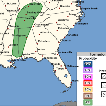
Saturday 2% seems about right. Modest flow is forecast in the upper levels. It's not really backed, but a cooking outflow boundary can take care of the low levels. See how much sun comes out between rounds. Otherwise, summer clusters with some organization and straight wind seems reasonable.
-
Summer of '57 is a bit before my time but I know KCMO had terrible flooding. Mercifully that's not the case this year. That said, parts of the Midwest have experienced flooding this summer. Summer of '97 was meh heat in the Plains. Y'all have to refresh my memory here. Let's see what the next 2-3 weeks brings out there.
-

Fall/Winter Banter - Football, Basketball, Snowball?
nrgjeff replied to John1122's topic in Tennessee Valley
I'll take the other side of that. Kalshi and Poly both have weather I believe. Even saw it on Draft Kings predictions, which could be dangerous lol! -
These dewpoints are simply unacceptable at these temps. Qatar World Cup weather is not what we need for ours! The only acceptable place for such temps/dews is chasing Bangladesh and with a proper hodograph. Otherwise it ain't right anywhere! I figure with more thunderstorms the humidity will hold in. Now looks like at least low 90s highs drags into next week. Heat index will stay 100 to 105. Guess after about a week of 110 that'll start to feel normal though. Until then enjoy the long weekend. Happy 250 America!
- 370 replies
-
- 1
-

-
- severe
- mountain snow
- (and 1 more)
-
Not bad for a mid-summer easterly flow MCS. Usually 15% is it for wind. We'll see.
-
Models are always bad in mesoscale season, as you know. At least this website is back to normal speed. Saturday had Crossville special written all over it. I gave up mid-afternoon after cells near Pikeville looked like crap. Then at sunset while I'm back home enjoying the World Cup, tornado warning Cumberland Co. What a hobby!
-
NBM which does really well on temps is mid-90s with some 97 and 98s. I was skeptical its first year or two. A mid-range high-res ensemble? Well the NBM has performed very well both winter and summer high demand weather. Guess it'll bust occasionally like anything, but I'm optimistic we can avoid widespread 100s. That said, somebody will get there. Also humidity will be atrocious. Also regardless of anything heat index 100-110 will be hazardous. We are not acclimated yet after the modest start to summer.
- 370 replies
-
- 4
-

-
- severe
- mountain snow
- (and 1 more)
-
East based super Nino should be warm and stormy. Agree the secondary pattern probably will be a couple weeks of Arctic dump. Loss of baroclinicty at the hemispheric level allows the jet stream to weaken, buckle, and deliver cold. Primary pattern I'm looking for mild mainly due to no cold air to deliver (outside the very meridional patterns) from the Midwest or even south-central Canada. East based is less conducive for other cold patterns. Maybe we can get southwest flow all winter. If it's not going to snow, give me severe! Might be my last post for a while. Why is the board so slow?
-
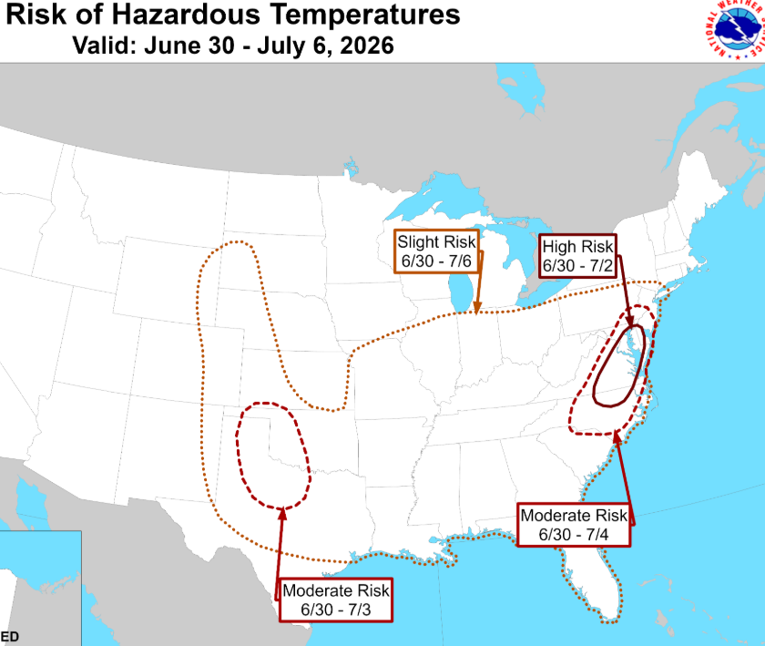
Starting this weekend through the Fourth looks like some summer temps are coming. Numerical models and humans looking at Nino and teleconnections promise it's brief. Talking the week in question; then, back to where we are now. Hopefully those signals for just one week hold!
- 370 replies
-
- 3
-
-
- severe
- mountain snow
- (and 1 more)
-
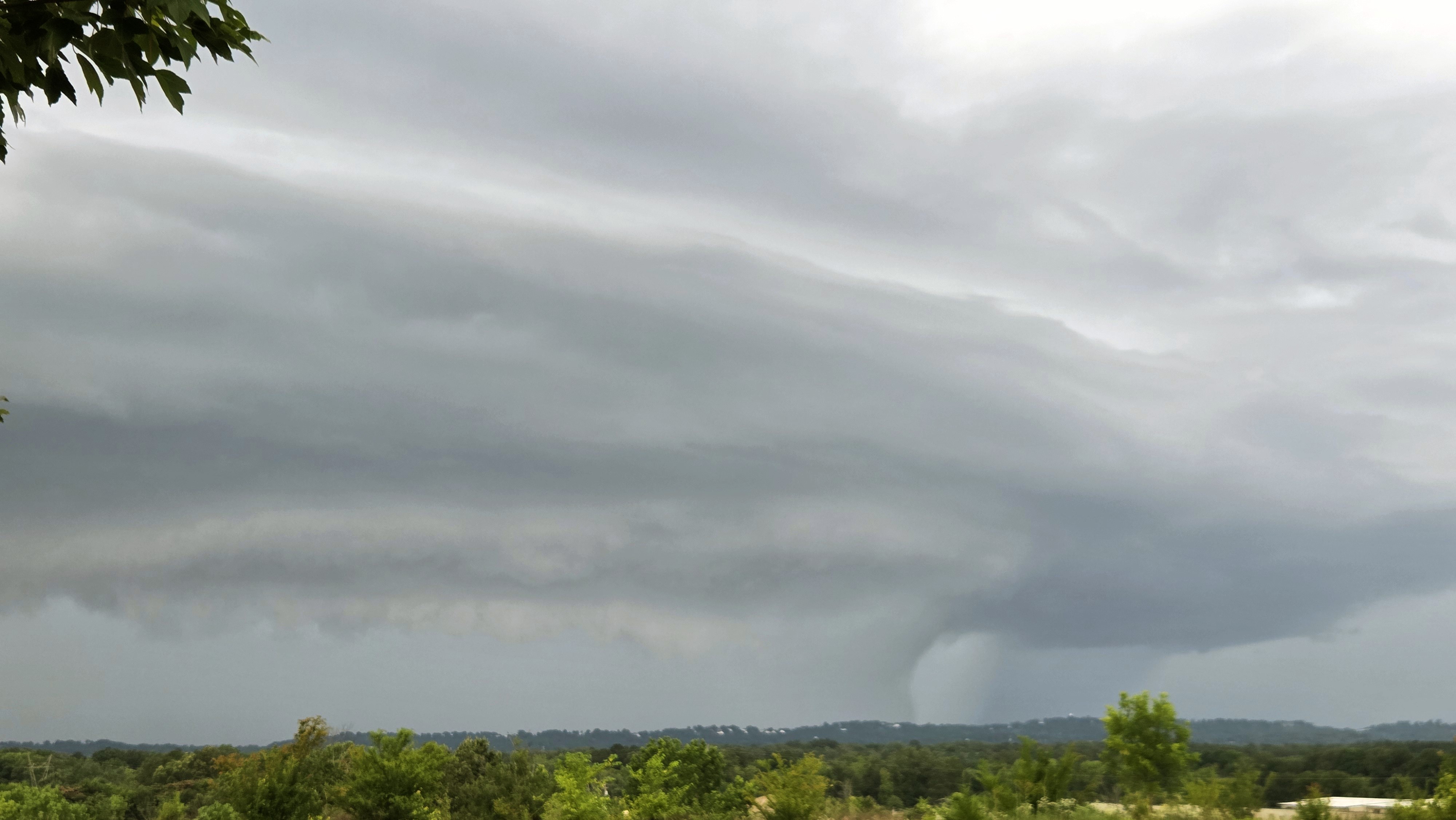
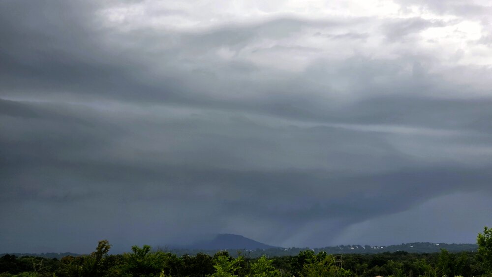
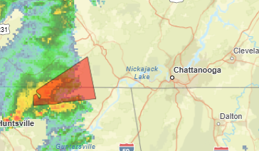
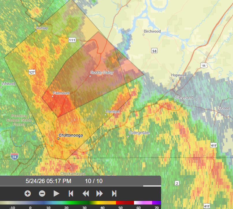
Here is what I saw about 6:30 Eastern from the North Georgia Costco. Lookout Mountain became envoloped. I infer a rain curtain punching out front, but could not discern any rotation. The 80 mph tag was probably justified. I'm shocked Chattanooga doesn't have more damage. As for the Georgia side, I saw a mini-cut (not pictured) but it wasn't enough to spin up a tornado. Warning was justified though; it was trying to rotate.

-
1:30 pm Central. I need that tornado warning back. Come on!
-
Local outflow boundary in June. Thats an easy decision to chase after work. 2% strong!
-
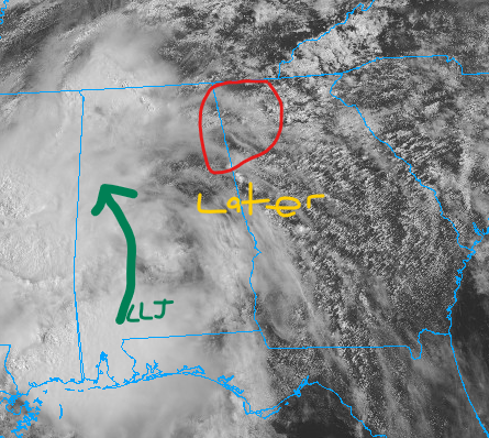
Considering a North Georgia chase late this afternoon. Target is the LLJ ahead of Aurthur remnants. Chase decision is pending proper destabilization. Satellite and radar trends match CAM forecasts at this point. Scattered t-storms are developing in Geogia in the morning sunshine. LLJ remains way back in southern MS/AL so I ignore morning to midday t-storms. New line of thunderstorms is expected to develop along the AL/GA line toward 22Z. LLJ should be roaring into that line. Current forecast calls for modest instability, more of a LLJ forced line, and I would not chase it. Now, if the North Georgia atmosphere can recharge in the wake of midday t-storms, we're in business! The said line would have greater instability and perhaps break up a bit. Even then, picking a cell is challenging. These tropical cells move quickly, and cycle quickly too. No obvious boundary to target either. Throw in that lovely (sarcastic) Georgia terrain, and ope! Then if the ATL Metro, hell no! Atlanta WFO AFD is similar thinking. They are probably right that the leading storms have the best chance of any severe. My interest is rotation though - and it's very conditional based on late afternoon instability. Probability of chase is only about 1/3 but it's not far (hard stop before ATL). Otherwise, World Cup matches start at Noon! 10:30 am Eastern, followed by Peachtree AFD highlights As the remnant system moves towards the CWA, models seem to finally be converging on a solution for exactly how the system moves across the area, for better or worse. CAMs have keyed in on the remnant circulation continuing to move to the NE across MS and AL, eventually coming into northern GA by the evening hours. During the afternoon, some day time heating even with cloud cover allows for multiple thunderstorms to form over all of north and central Georgia - these will likely contain most of the severe threat. A line of storms is expected to form across portions of Alabama later in the evening that extends into central Georgia during the late evening to early overnight hours. Simultaneously, the core of the remnant low moves into north Georgia, bringing some heavy rainfall and potential for strong winds that are mixed down from a developing 850 mb jet.
-
Yeah it'll split around us. Front should get into northwest Tenn. Risk farther east and south is that subsidence northwest of the decaying TC squashes things. Then the said TC remnants are sliding deep south. That'd be nice in winter. Somebody has to say it, lol!
- 370 replies
-
- 1
-
-
- severe
- mountain snow
- (and 1 more)
-
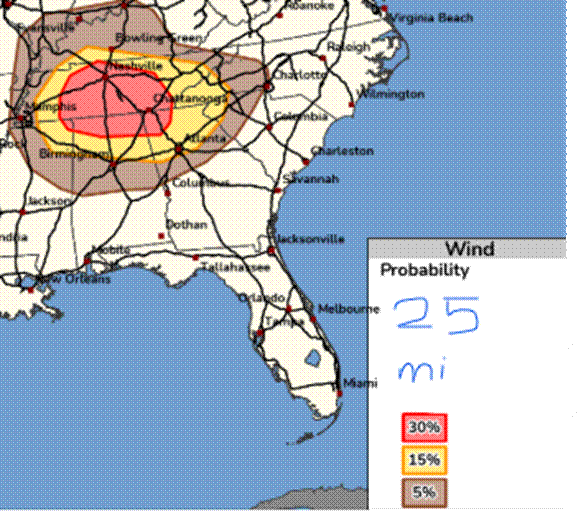
The Midwest is going to have a Deep South outbreak on Wednesday, with fast storm motion and low LCLs. At least their trees aren’t as bad. Oh but we love battling trees, lol! And we don’t have Midwest chaser convergence. Enter the Southeast on Thursday! Remnant of PTC 1 (perhaps Arthur) will scoot from Mississippi through Alabama into Georgia. Despite hideous terrain, it’s close. From SPC Day 3 Southeast... The remnants of Potential Tropical Cyclone 1 will continue to move through the northern Gulf into the Southeast on Thursday. With 70+ dewpoints likely to be ahead of this feature, even muted surface heating will promote moderate instability will develop. With locally enhanced shear near the remnant low, isolated strong wind gusts and perhaps a tornado or two will be possible. Should greater destabilization occur, higher probabilities could be warranted.
-
Looks like a classic Illinois day on Wednesday. Parameters are high, and that could all go into a windstorm, but I have to favor supercells initially. So far looks like morning rain will scoot out and leave a lovely outflow boundary with which to work. Factors that should get a big ol' bow echo going are WAA at 850 / 700 mb, 500 mb orientation / height falls, deepening sfc low, high instability, and an east-west boundary (outflow). That said, barring a quick mess, I'm thinking Illinois will book another tornado day. Models line up with the morning rain pattern recognition. In this case looks like it gets away in plenty of time to reheat. Outflow boundary OFB will locally enhance low-level shear. Some of the soundings are little skinny, but that may be a result of temperature forecast uncertainty. Should be skinny north of the OFB, probably fatter south of it. Both sides the LI is robust. Should get supercells along both the synoptic boundary and outflow. As usual we favor the boundary intersection. Also as usual, exact strategy will be a game time decision. Right on the intersection, or 1-2 cells east of it. Back on Thursday I believe the cyclical beast of the day was east of the main triple point, but on another differential heating boundary. Time will tell how Wednesday goes. From pattern recognition I infer initial tornadoes, perhaps 1-3 cyclical supercells. Then it will congeal into quite the bow echo.
-
Seems to be a wall at the Appalachian Mountains. Some SC peeps on X are gnashing their teeth. They'll get some storms and wind but it literally blows over. Slower moving rain and systems are here on our side. Thursday looks like more of the same. Big ol' slug of moisture will come up from the Gulf. Some hints of even a LLJ into the Tennessee Valley. After some good rain around here the system speeds up and fills over the Carolinas with lower QPF that way. We still have a long way to go on our own drought. I suppose we'll make more progress later this week. My lawn seems perfectly fine now.
-
Friday the whole thing got undercut by outflow. Then it regenerated east of the Apps. Speaking of the Mountains, got a Slight on Sunday. The mountains are always calling, but I'm not sure if that's for chasing, lol! I'm really interested in midweek. Verbatim it's a Midwest issue. We'll just see where outflow boundaries may lie. Winds aloft are forecast to be pretty strong for mid-June by mid-week, stronger than this current weekend.
-
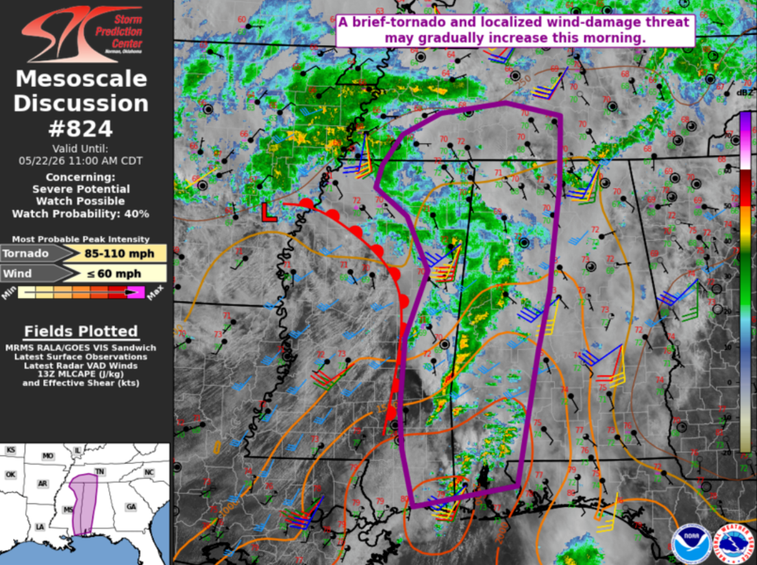
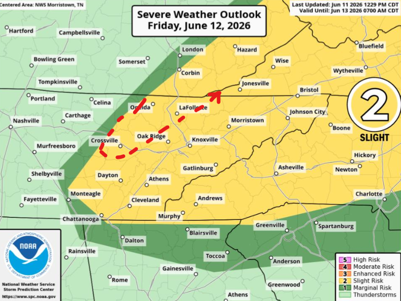
Friday is kind of Slight or nothing with that CAPE. Where it goes it'll go fast. Only reason for a marginal is placement of initiation; otherwise, should go from shower to severe quickly. Wind will be the main threat though. MRX has some concern about a boundary draped across the region. Winds will mostly be veered off which keeps the threat straight. However any boundary cooking in June can do things right where the SRH is locally higher. Then if the boundary is on the Upper Plateau, we know what can happen. While SPC omits 2% MRX leaves the door cracked. (AFD not map) Red line is mine. Keep it broad north of Tenn. I'm less familiar with the terrain.
-
yeah wake me up when football starts. North America pattern is really going to the dogs. Rex block will be replaces by an Omega block. Anything underneath is trash, no wind shear, plus too much rain. Plains is totally shut down east of the Rockies foothills. Should still get thunderstorms around here with systems passing through. Probably not much severe. Breaking the drought takes several rounds, so that's probably the good part of all this mess.
-
Oh wow I was mainly kidding about the obligatory Upper Plateau tornado, posts from Thursday and early Friday. Anybody still have the radar shots from the time? I doubt they missed an obvious signature. Maybe it was one of those difficult spin-ups. UPDATE for Sunday: So close yet so blob. No chase attempt is being made. We are safe in East Brainerd, not even in the severe polygon. Looks windy on US-27 where TN-153 comes in. Signal Mtn members check in when you can!
-
If northeast Alabama into northwest Georgia can push 80 degrees this may expand east. I still think Tennessee will be too messy. We'll see about Tenn. Crossville likes to Crossville these skinny CAPE low level shear days. Upper Plateau gets first crack at the LLJ. Otherwise, as of 10:30 Central Time, a west-east differential heating boundary is noted from Birmingham to Atlanta. Northward lift will depend on precip.

-
Oh my I'm going to have a nervous breakdown because they can't ever get clear of the trees! That is a truly crisp sculpted specimen though. Just a little more jet dynamics (upper and LLJ) would have produced. Which brings me to Friday. SPC language reads like a decaying tropical system. Meh lapse rates but low-level helicity. Be nice to get more structure like that at least. Drawback is that - just like tropical - anything will be brief. Advantage is it'll be mid-afternoon, no late drive back. We'll see. Marginal chance to save my season, which right now is going about like that of my KC Royals. Valid Friday May 22
-
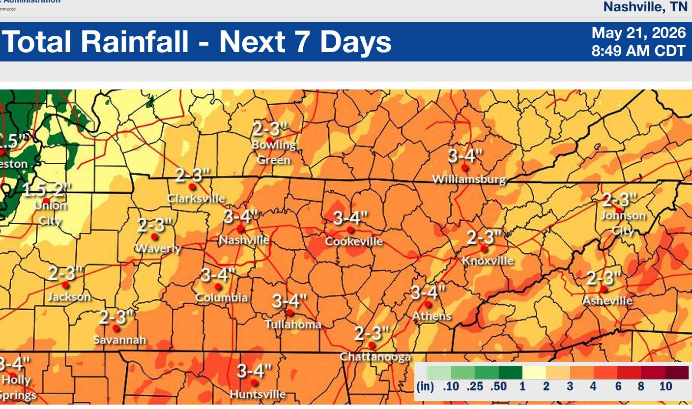
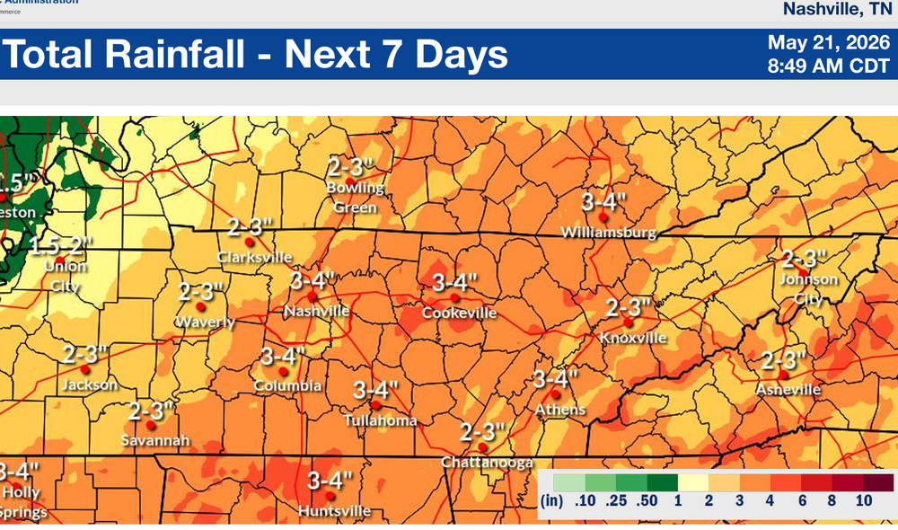
Shockingly Chattanooga got a true summer morning soaker. Also the CPC 6-10 day chart is AN rainfall. Given what's on the way Friday and Monday, scattered over the weekend, and whatever after that.. Barring an epic failure some drought relief is incoming.
- 370 replies
-
- 1
-

-
- severe
- mountain snow
- (and 1 more)
-
Thunderstorms are over the Appalachians and other terrain today. See PA, WV, and soon today our Mountains. So, is that how summer is gonna go? They guy who can't chase this weekend is venting. Thanks for reading. Augh!