IUsedToHateCold
-
Posts
838 -
Joined
-
Last visited
Content Type
Profiles
Blogs
Forums
American Weather
Media Demo
Store
Gallery
Everything posted by IUsedToHateCold
-
We are only beginning to learn how dreadful the flooding in western NC is- most of the affected area is cut off, but you can see already that this is a total disaster. Entire towns gone.
-

Tropical Storm Debby: Mid-Atlantic Impacts
IUsedToHateCold replied to WxWatcher007's topic in Mid Atlantic
This looks like a total whiff for me, outside of a small tornado threat. Rare, but I’ll take it.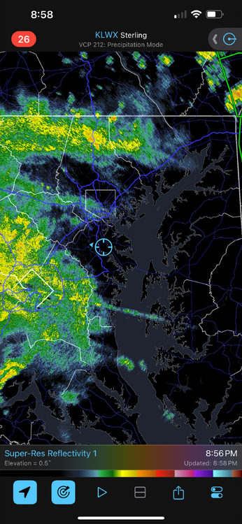
-
I am eyeballing 102 on my outdoor mercury thermometer. Pretty incredible
-
The Weekend Rule? Saturday 2/17 - The Icon Storm
IUsedToHateCold replied to DDweatherman's topic in Mid Atlantic
During the storm a few weeks ago the HRRR had no clue what was going on until the storm was on top of us. Just toss it. -
The Weekend Rule? Saturday 2/17 - The Icon Storm
IUsedToHateCold replied to DDweatherman's topic in Mid Atlantic
At this range I’m all in on the NAM. Bring it -
2024 Valentines Day Who the Hell Knows - Comeback Thread
IUsedToHateCold replied to DDweatherman's topic in Mid Atlantic
3 year old looked out the window and said it’s snowing. I didn’t believe her. I was wrong. 34 degrees -
All I’ve gathered from my years here is that you want the red orb on top of us and the blue orb to the right of us
- 2,509 replies
-
- 2
-

-

-
- weenie fest or weenie roast?
- weenies got roasted
- (and 2 more)
-
All you need is a passport, a car, and some cash
- 2,509 replies
-
- 1
-
-
- weenie fest or weenie roast?
- weenies got roasted
- (and 2 more)
-
The groundhog is lurking around in here somewhere. Good thing he's only been 30% correct in the past 10 years.
-
Not like this. This is special. It's even 60+ degrees near State College, PA (where my in-laws live). In January.
-
75 degrees on my old mercury thermometer. Unbelievable.
-
Didn’t clear to get accurate measurements but I’m somewhere around 4 inches
-
Jan/Early Feb Medium/Long Range Discussion Part 3
IUsedToHateCold replied to WinterWxLuvr's topic in Mid Atlantic
I don’t know much about LR forecasting but I know that we win on pattern changes and we have the high where we want it for next Friday. I’ll be watching closely for a chance at something, even if it’s a snow to rain event -
FTFY
-
Jan 18-19 Storm Threat: Bob Chill made me do it
IUsedToHateCold replied to stormtracker's topic in Mid Atlantic
NAM really isn’t in decent range yet. Let’s see what the GooFus has to say -
9 degrees.
-
Jan 18-19 Storm Threat: Bob Chill made me do it
IUsedToHateCold replied to stormtracker's topic in Mid Atlantic
No Tacos For You! -
Jan 15-16 Storm Thread 3: Obs and Disco
IUsedToHateCold replied to stormtracker's topic in Mid Atlantic
My final obs of the night - measured a hair under 4 inches here. Still some light flakes coming down, temperature 28. And my final thought of the night. When it snows, this place is like a giant party and we're all drunk. Except, without a drop of alcohol. We're all drunk on the fucking snow. Good night. I know I'll be seeing you all here tomorrow. -
Jan 15-16 Storm Thread 3: Obs and Disco
IUsedToHateCold replied to stormtracker's topic in Mid Atlantic
Yeah that one, lol -
Jan 15-16 Storm Thread 3: Obs and Disco
IUsedToHateCold replied to stormtracker's topic in Mid Atlantic
I've been following since AmWx (2006 or so?). I think if you're into this type of thing, you're into it for life. I don't think any of us are going anywhere... -
Jan 15-16 Storm Thread 3: Obs and Disco
IUsedToHateCold replied to stormtracker's topic in Mid Atlantic
Just in: Germantown upgraded to Excessive Heat Warning. Temperatures expected to reach 105 degrees overnight with liquid magmafall expected. All residents advised to stay indoors. -
Jan 15-16 Storm Thread 3: Obs and Disco
IUsedToHateCold replied to stormtracker's topic in Mid Atlantic
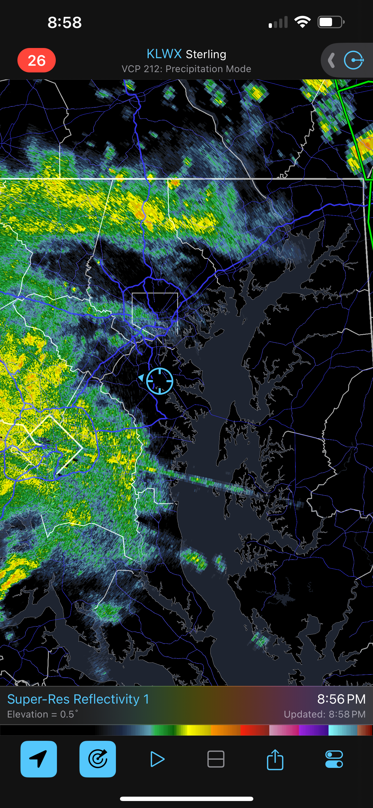
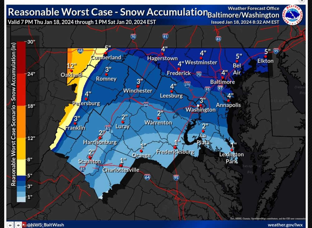
3.5 inches. Still got light snow despite that the dark greens are now north of 95, hanging on to some lighter green precip for now. Eager to see what the coastal does, but I have a good feeling someone in northern MD is going to walk away with 10+ inches from this event. -
Jan 15-16 Storm Thread 3: Obs and Disco
IUsedToHateCold replied to stormtracker's topic in Mid Atlantic
Picture from my walk. The perfect winter’s night.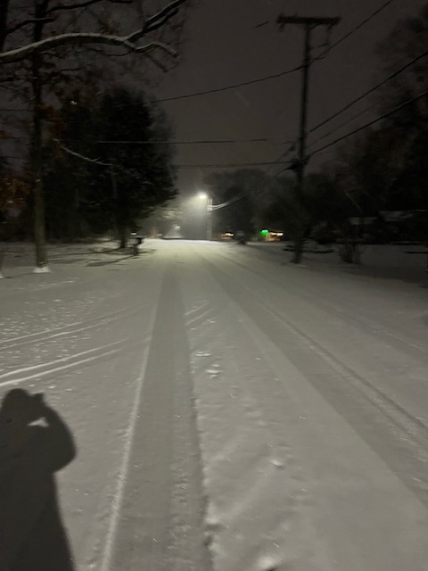
-
Jan 15-16 Storm Thread 3: Obs and Disco
IUsedToHateCold replied to stormtracker's topic in Mid Atlantic
Measured 2.25 inches. 28 degrees with SN. Coming down very nicely.