

IUsedToHateCold
-
Posts
629 -
Joined
-
Last visited
Content Type
Profiles
Blogs
Forums
American Weather
Media Demo
Store
Gallery
Posts posted by IUsedToHateCold
-
-
2 hours ago, 40/70 Benchmark said:
How do you figure?
Tendency for suppression during Ninas. There have been two major snowstorms in NC in December in the past 12 years: 2010 and 2018, 2010 was a Nina year.
-
34 minutes ago, MetalCapsFan said:
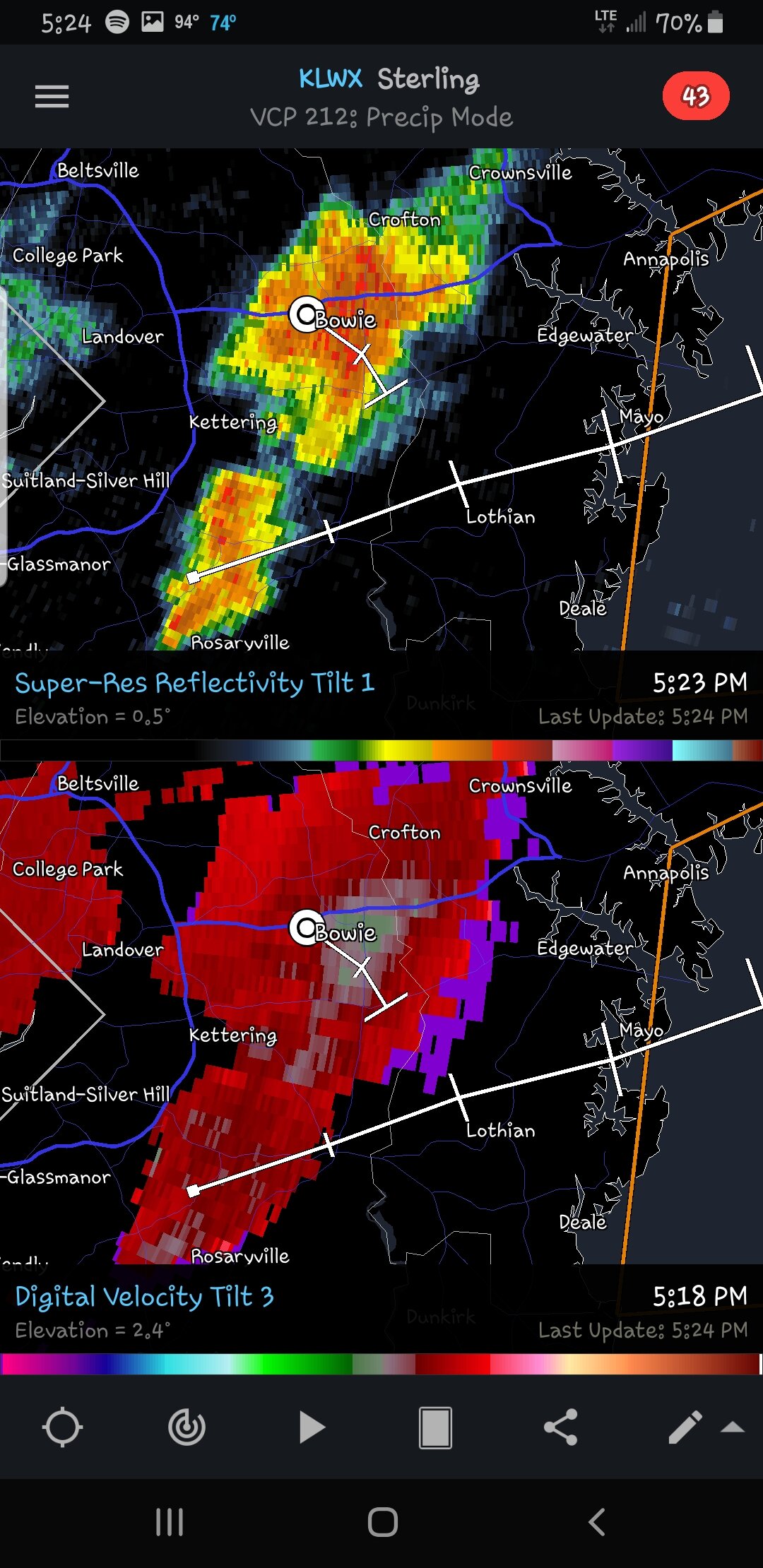
Hey, have relatives down in Bowie, anything to be concerned about here?
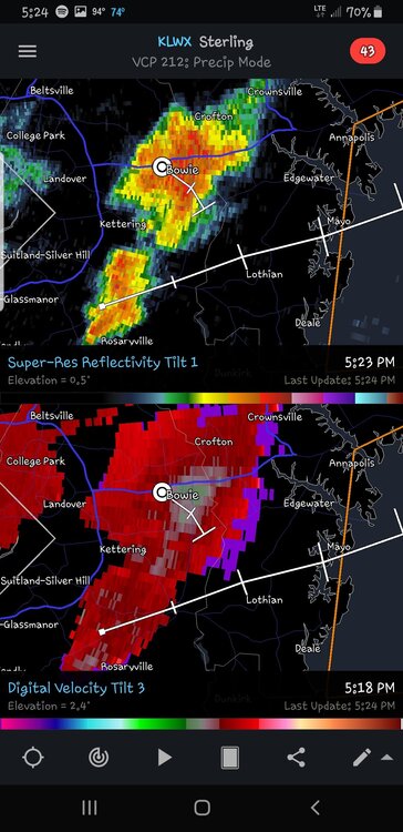
Nope. Just an ordinary T-storm.
-
 1
1
-
-
I’m not thrilled by the idea of a front loaded winter, especially if the Niña holds. I think we would see a couple of small events in December with the possibility of a massive storm for NC. Better chances for a bigger event would be in late Feb or March.
We could roll lucky though. We can always roll lucky.
-
22 hours ago, BlizzardNole said:
Another dry day in the central MD desert. Yard is hard as a rock and it's really gonna get crispy here with hot temps moving in this week
If rain is what you want then come down here east of the fall line. You will never need to worry about rain again

-
On 7/10/2022 at 11:20 PM, WEATHER53 said:
I think over last 20 years this has become more determinant for us and Enso less so. We gotta have the “right” cold air.
SSW and Mjo is still hard to find predictability in. Get the negative nap/ao that’s not misplaced too far south and see what happens with other factors.ENSO plays a role in the storm track. We’ve been flip flopping between cutters and suppression a lot during our La Niña winters. There have been a number of smaller or medium events some years that sometimes give us a decent winter, but a lack of epic storms directly hitting us (last was 2016)
If this is another Niña winter I’d expect the same.
-
Massive damage in my neighborhood too, lots of trees and power lines down. Haven’t seen anything like this since the derecho
-
40 minutes ago, WEATHER53 said:
0.65” in 20 minutes and 35 mph winds. Got a video from Bowie and those winds were intense, looked like 65 mph
It definitely delivered. At least 50mph gusts (maybe more) , pea sized hail, and no power.
-
Quote
PUBLIC INFORMATION STATEMENT
NATIONAL WEATHER SERVICE BALTIMORE MD/WASHINGTON DC
218 PM EDT WED JUL 6 2022

...NWS DAMAGE SURVEY FOR BOWIE MD TORNADO EVENT TUESDAY
JULY 5 2022...CORRECTED DAY

RATING: EF1
ESTIMATED PEAK WIND: 90 MPH
PATH LENGTH: 1.0 MILE
PATH WIDTH: 125 YARDS
FATALITIES: 0
INJURIES: 0

START DATE: JUL 5 2022
START TIME: 531 PM EDT
START LOCATION: 1 NW BOWIE MD
START LAT/LON: 38.9710/-76.7470

END DATE: JUN 5 2022
END TIME: 534 PM EDT
END LOCATION: 1 NE BOWIE MD
END LAT/LON: 38.9697/-76.7281

A SUPERCELL THUNDERSTORM SPAWNED A BRIEF EF1 TORNADO JUST NORTH OF
BOWIE, MD IN PRINCE GEORGES COUNTY LATE ON TUESDAY AFTERNOON JULY 5
2022 BETWEEN 5:31 AND 5:34 PM EDT. THIS SUPERCELL SPAWNED ALONG THE
HOWARD/MONTGOMERY COUNTY LINE AS A RESULT OF A REMNANT MESOSCALE
CONVECTIVE VORTEX MOVING THROUGH THE REGION WHICH HAD MOVED THROUGH
THE OHIO VALLEY EARLIER IN THE DAY. IT EVOLVED INTO A CLUSTER OF
CELLS INITIALLY BEFORE SPLITTING OFF INTO AN INDIVIDUAL SUPERCELL
THAT WOULD DEVELOP ROTATION AS IT MOVED OUT OF SOUTHEASTERN
MONTGOMERY COUNTY INTO NORTHWESTERN PRINCE GEORGES COUNTY.

THE TORNADO CAUSED EXTENSIVE TREE DAMAGE IN THE SOMERSET
SUBDIVISION JUST NORTH OF BOWIE, MD. THERE WAS ALSO ONCE INCIDENCE
WHERE A TREE HAD FALLEN ON TOP OF RESIDENCE ON STAFFORD LN. THE
MOST CONCENTRATED AREAS OF DAMAGE OCCURRED BETWEEN STAFFORD LN.
AND SABER LN. HOWEVER, THERE WERE SEVERAL OTHER TREES DOWN IN THE
AREA OUTSIDE OF THE MORE CONCENTRATED TORNADIC DAMAGE,
PARTICULARLY ALONG BUCKINGHAM DRIVE PERPENDICULAR TO WHITE MARSH
BRANCH. AT THIS LOCATION ALONG BUCKINGHAM DRIVE, TREES FELL UPON
POWER LINES, SNAPPING SEVERAL SUPPORTING UTILITY POLES.

THE TORNADO INITIALLY TOUCHED DOWN AROUND TARRAGON LN. AND TRACKED
EASTWARD OVER THE BOWIE HIGH SCHOOL ANNEX BEFORE TRACKING INTO THE
SOMERSET SUBDIVISION, WHERE THE MAJORITY OF THE DAMAGE WAS
OBSERVED. THE TORNADO WOULD THEN LIFT JUST BEFORE REACHING
SOUTHERN PORTIONS OF WHITEMARSH PARK.

KLWX WSR-88D DOPPLER RADAR IN STERLING VA DEPICTED A TIGHT
VELOCITY COUPLET THAT CORRESPONDED TO THE LOCATION OF THE DAMAGE
DESCRIBED ABOVE. RESIDENTS IN THE AREA NOTED THAT THEY RECEIVED
THE WIRELESS EMERGENCY ALERT DISSEMINATING THE TORNADO WARNING
ISSUED BY THE NATIONAL WEATHER SERVICE BALTIMORE/WASHINGTON
WEATHER FORECAST OFFICE PRIOR TO THE DAMAGE OCCURRING, AND TOOK
APPROPRIATE ACTION TO REDUCE THEIR RISK OF INJURY FROM THE
TORNADO.

THE BALTIMORE/WASHINGTON WEATHER FORECAST OFFICE IN STERLING,
THANKS THE CITY OF BOWIE AND THE PRINCE GEORGES COUNTY DEPARTMENT
OF EMERGENCY SERVICES FOR THEIR ASSISTANCE IN THIS SURVEY, ALONG
WITH THE RESIDENTS OF PRINCE GEORGES COUNTY THAT WERE WITNESS TO
THIS TORNADO EVENT.

EF SCALE: THE ENHANCED FUJITA SCALE CLASSIFIES TORNADOES INTO THE
FOLLOWING CATEGORIES:

EF0.........65 TO 85 MPH
EF1.........86 TO 110 MPH
EF2.........111 TO 135 MPH
EF3.........136 TO 165 MPH
EF4.........166 TO 200 MPH
EF5.........>200 MPH

$$

LEDBETTER/LEE
-
 2
2
-
-
I was literally 3 miles away and I didn't see it. :(. I just saw wall cloud and some wind.
-
I’ll make sure to keep the trophy on my wall
 . On to next winter
-
Woohoo! Never thought I'd ever have a chance of winning this thing.
")
-
2
-
-
All snow now, sticking to grass in Bowie. 33 degrees
-
And just like that, I’ve gone to a rain/sleet/snow mix here in Bowie. Fast changeover.
-
Rain here in Bowie. 36 degrees
-
I’m so glad some of you declared winter over 5 weeks ago

I’d be happy with an inch.
-
Yesterday was bad for my yard but good for me in this contest.
-
A decent light snow under the current darker green band. Still nothing more than a T. Temp 33
-
Light snow in the 95 band. Grass turning white. 32 degrees
-
50/31 in Bowie. Feels like an underperformer, but I won’t judge until it’s done.
-
1
-
-
24 minutes ago, IronTy said:
Nope, it's all mine. Well and the deer and bear and bobcats.
Now to be clear...my wife paid for it (hattip @stormtracker). But behind every private equity titan woman is a captive man. So yeah, it's mine.
You married well. Enjoy your future snow.
Also let’s toss the 18z Euro. Cause it’s not king
-
1
-
-
40/35, I doubt any snow is falling here. Since it will be rain, we will manage to eek every drop of QPF we can get though.
Seems like it could be a surprise snow storm for some to the N/W (which they are due)
-
1
-
-
10 minutes ago, Ji said:51 minutes ago, CAPE said:I quickly scanned through the members focusing on the 14-15th window- there are 3-4 members(out of 50) on the 0z EPS that have low pressure to our SE and tucked close to the coast- healthy storms that produce some significant snow for our region. The majority are offshore or all NS. Overall theme is progressive/offshore/late.
Ya man winter is being put in the coffin now
I know someone who can offer you a deal on a coffin @WxWatcher007
Seriously though, it's Feb 6th. I've seen 6 inches of snow as late as like March 20th. At least 42 days of winter remain.
-
 1
1
-
-
22 minutes ago, Maestrobjwa said:
TRGAS?
The royal GFS allows snow
-
5
-
1
-
-
Torching. 58 degrees
Winter 2022-23
in Mid Atlantic
Posted
To make a totally unscientific guess, the predominant Nina state over the past 22 years (11 out of 22 years) is a global feedback mechanism to cool the globe in response to climate change. I wouldn't be surprised at all if there is a 4th Nina after this one, or that the next 7 out of 10 winters are Nina winters.
If right, it will make winter forecasts easier in one way.