Terpeast
-
Posts
6,591 -
Joined
-
Last visited
Content Type
Profiles
Blogs
Forums
American Weather
Media Demo
Store
Gallery
Everything posted by Terpeast
-
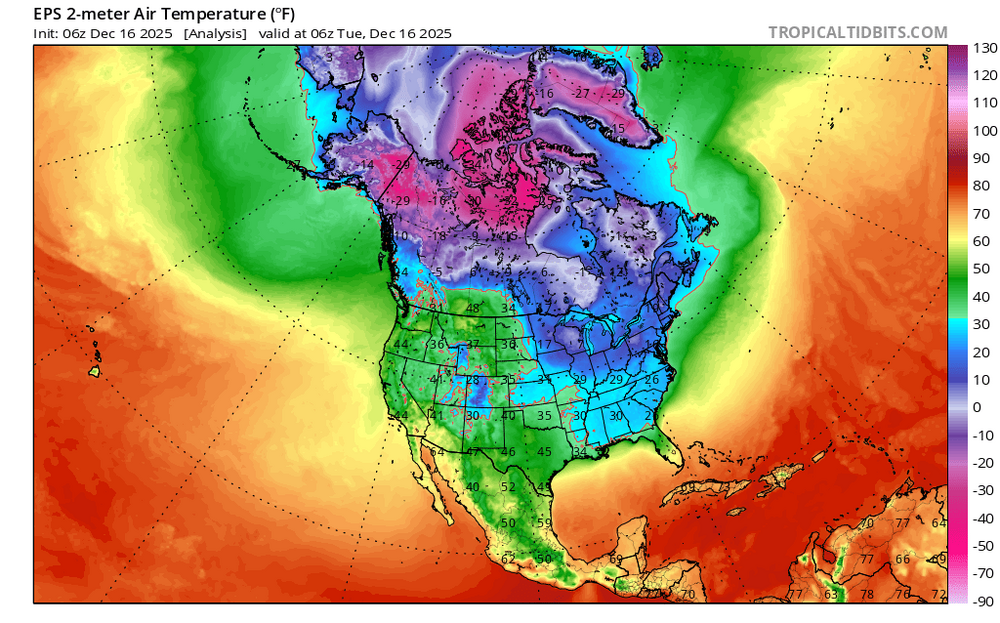
Clearly the goal posts are still very wide, and until the block establishes itself there will be a lot of uncertainty in our sensible weather outcomes. 6z takes us to the promised land while 12z shows us a poor case scenario. What’s most likely to happen is something in the middle, cool dreary CAD with maybe a mixed event with more snow to the north of this sub (and even this is low confidence).
-
Good trends on ensembles. We may have something trackable here, which is sooner than I thought. Hopefully it is that kind of winter this year.
-
Despite the yellows over us, this isn't exactly a warm look. Anticyclonic ridge out west where we want it, and broad cyclonic trough over midwest/east/NE. Trough NW of Hawaii with -EPO/-WPO and hint of GL blocking, with continued Scand ridging. Second half of Jan could be fun.
-
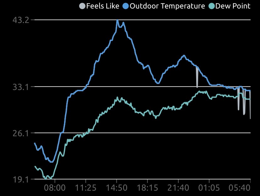
Fell short of the forecasted high of 51, only made it to 48.
-
Yep, h5 pattern seems to be trying for some light to moderate events for MA-NE. Maybe a 96-like big dog can happen, but extremely unlikely.
-
After a low of 13.5, temp is 41 which feels very comfortable compared to yesterday.
-
Torch moved to boxing day. That i am fine with. Just keep xmas eve and day cooler
-
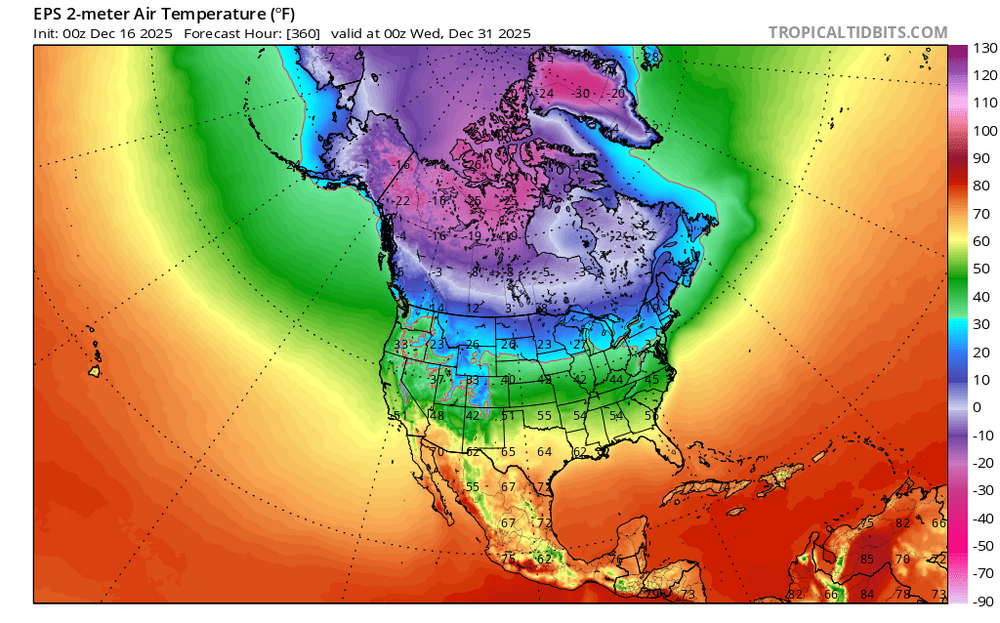
I don't think so. Today: 2 weeks from now: Still on our side of the globe and not too far from a widespread cold snap that could extend at least a couple of weeks down this way in January. Yes, it's one ensemble run, but the source/placement of cold air hasn't really changed all that much from run to run.
-
Yep I see WH forcing in the hovmoller's forecasts, of which GFS is performing well lately. It's trying to go into phases 1 and 2, with a bit of ensemble support.
-
Quick check on the ensembles today looks like a solid -pna pattern for at least the next two weeks with no credible snow threats for the MA. Perhaps some cold shots over the NE and MA. But we’re gonna have to wait this out a bit before the scand ridge retros into a GL block around new years.
-
26 for the high. Legit cold
-
I’m glad the models are fading the warmth around the holidays, but as long as the PNA is negative its an unfavorable setup for snow in the MA. Maybe we can sneak in a wintry mix event.
-
Low of 16.7
-
Similar thoughts. We’ll probably lose the first week of Jan, but second week may get more interesting with tracking threats.
-
This December hasn’t been too shabby in general, though some were unlucky for their back yards. I tend to agree that a ratter is an extremely unlikely scenario.
-
Seeing lots of CAD setups in this set. Maybe we can sneak in a wintry mix event before new years
-
22 F, feels like 13, little if any melting. Frozen inch everywhere
-
Objectively, this was a 4” storm for most of NYC. I don’t think that if cpk gets 3.9” then the winter is an auto fail by this standard. Just as 4.1” doesn’t necessarily mean we’re in for a 50” blockbuster.
-
The models have been biasing the PNA too low, so it may only end up being -2sd at the lowest this month. Also saw from GaWx that if Dec averages -pna, Jan tends to flip to +pna at least by the second half of the month. The bias corrected PNA forecasts trending to neutral by new years.
-
I’m starting to wonder if the mesos have a bias for more qpf in the 24 hours leading up to the event. We know the nam does this, but do other mesos have that same bias? I think the HRRR was onto something with the local minima over Loudoun.
-
I would have done better had I stuck to my initial forecast. It does look like my thoughts on the max strip from MoCo through SE PA verified warning criteria, but busted for the dmv. Some in the dmv were lucky enough to break an inch, and that would have verified on the low end. Still calling it a bust because precip came a bit early and temps took a while to catch up, and that hurt us from the start. Had it been an hour or so in our favor, we would have added another inch everywhere here. 4” would have been greedy, but a general 1-3” call would have been achieved if the precip band was an hour later. These things come down to luck and timing as always. Glad those to the NE got theirs, though!
-
12/5: 1.5” 12/14: 1.0” Total: 2.5”
-
Ended up with 1.0”
-
At least everything is white. Pretty with the xmas lights!
-
I was at 33 at 7 pm, then went up to 37 and once precip started back down to 33 and just now 32 as the back edge nears. The 4 degree rise can be attributed to the pooling of warmer air ahead of the front, kind of like the burst of temps before summer tstorms arrive. You should do much better over there, CAPE.