Terpeast
-
Posts
6,687 -
Joined
-
Last visited
Content Type
Profiles
Blogs
Forums
American Weather
Media Demo
Store
Gallery
Everything posted by Terpeast
-
Jan 24-26 Weekend Snow and Sleetfest Model Thread Part Tres
Terpeast replied to H2O's topic in Mid Atlantic
We’re close in location, euro gives us 8-10” before we flip -
We shall see, but one thing is for sure - we have another threat to track, and we will be doing a lot of tracking.
-
I also think that cold air will not be much of an issue because of all the snow/ice cover we will have across the country east of the Mississippi
-
I have a feeling that we’re gonna go another week without much sleep
-
Jan 24-26 Weekend Snow and Sleetfest Model Thread Part Tres
Terpeast replied to H2O's topic in Mid Atlantic
That big of a change in one run, outside of range? Toss until other models say otherwise. -
Jan 24-26 Weekend Snow and Sleetfest Model Thread Part Tres
Terpeast replied to H2O's topic in Mid Atlantic
Unless the synoptics changed drastically, I don't think the freezing rain in the PA turnpike is right. The arctic high is already stronger than had been modeled (1050) and the cold air both at surface and aloft isn't going to go that easily. I can see a flip up to the M/D line by early afternoon, but probably not much further north than that given recent trends. -
Jan 24-26 Weekend Snow and Sleetfest Model Thread Part Tres
Terpeast replied to H2O's topic in Mid Atlantic
By tonight/tomorrow 0z-12z we should see NAM start handling the thermals better. -
Jan 24-26 Weekend Snow and Sleetfest Model Thread Part Tres
Terpeast replied to H2O's topic in Mid Atlantic
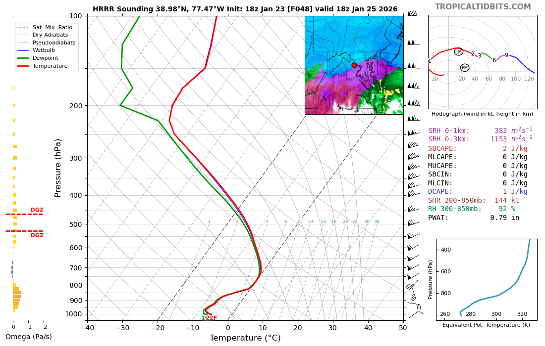
DGZ looks fantastic on the HRRR right before the flip, too. If this holds, oh my... -
Jan 24-26 Weekend Snow and Sleetfest Model Thread Part Tres
Terpeast replied to H2O's topic in Mid Atlantic
IAD is close to flipping at 48 (18z) on HRRR. This is probably the time it flips.
-
Jan 24-26 Weekend Snow and Sleetfest Model Thread Part Tres
Terpeast replied to H2O's topic in Mid Atlantic
Love the HRRR run. Probably out of its range, but see its trying to start a coastal. -
Jan 24-26 Weekend Snow and Sleetfest Model Thread Part Tres
Terpeast replied to H2O's topic in Mid Atlantic
Yes thats snow, but probably with some riming. Think this would give us an hour before fully flipping to sleet -
Jan 24-26 Weekend Snow and Sleetfest Model Thread Part Tres
Terpeast replied to H2O's topic in Mid Atlantic
That warm layer on your sounding is 5-10kft. Far above 3,000 but plenty of room to refreeze into sleet -
Jan 24-26 Weekend Snow and Sleetfest Model Thread Part Tres
Terpeast replied to H2O's topic in Mid Atlantic
If I had to guess where the true northern extent of the 800-750 warm nose, it would be along the darkest blue line instead of that 0 line on this 700 map. Maybe not even that far. -
I think the gfs and euro are meeting in the middle, with the cmc joining them. Starting tomorrow the synoptics should be in place, and we’ll start taking the thermals seriously. Hopefully the NAM is wrong today and shifts colder tomorrow. All we need is a 20-30 mile shift to the cooler side at 700-850, and double digits is in play along and west of the fall line.
-
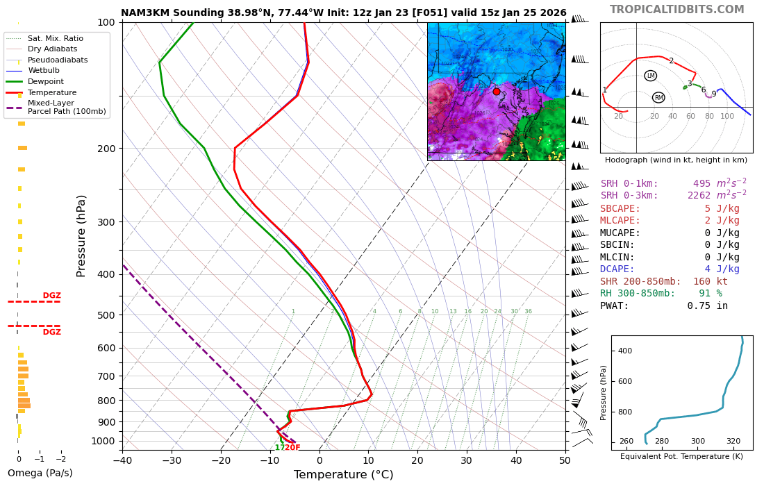
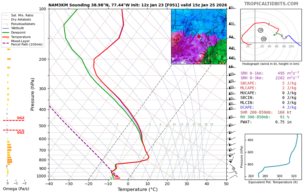
I don't know how reliable 3k is with thermal profiles at 51 hours out, but that warm nose really punches through at 750-800 mb. One hour prior to this, it was still left of the 0C line.
-
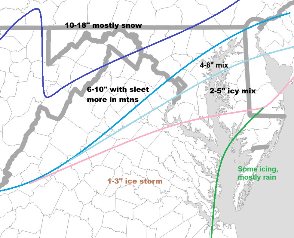
Low end map from LWX
-
Fwiw 3k has the sleet line a tick south at hr 34.
-
I usually don’t report sleet on top of snow. This time I will, but I’ll take separate measurements to get the snow accum right when it flips, and then get the sleet accum just to differentiate the two when reporting the total. Also given that sleet is counted, the bullish nws forecasts make a little more sense.
-
RGEM mixes us at the same time/hour as the Euro does. Gives us 10" areawide before mixing. I'll take it!
-
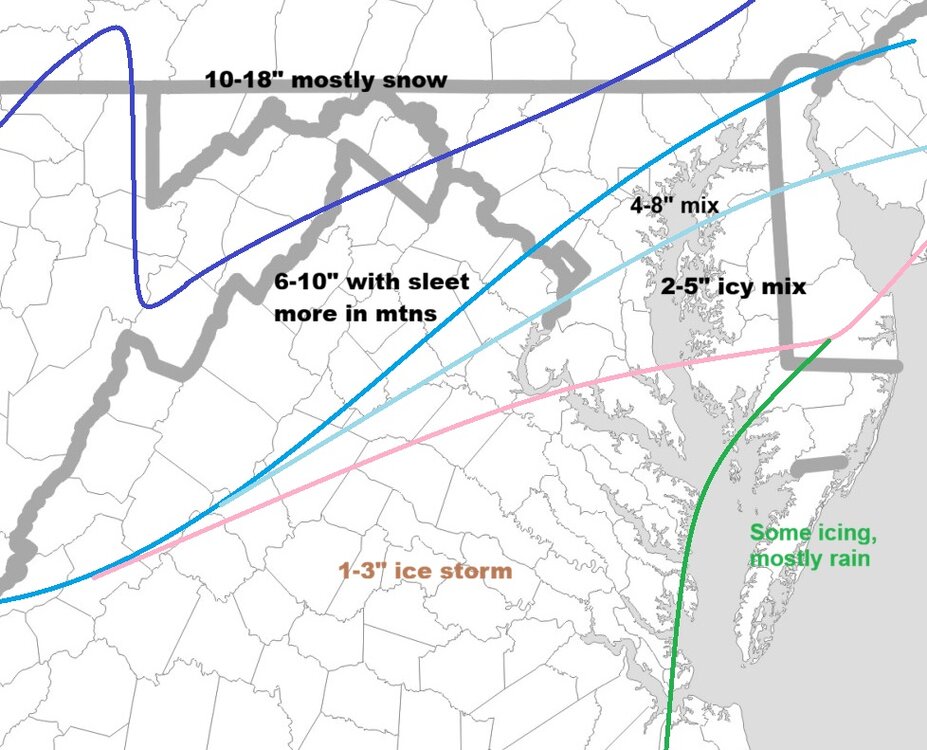
Here's my first call on what I think is going to happen in our forum. More confidence in a 30 mile corridor along DC/Balt and NW. Less confidence in the SW quadrant of this map (so please don't hammer me if you live somewhere like Roanoke or Cville.
-
Busy times ahead!
-
Yep. This is the kind of storm I've often seen when I was a kid. PA gets the most snow while we mix. I was jealous of State College then. But they've had a terrible, terrible run at snowfall in recent years. Like, worse than us.
-
Sorry, meant 25%. iow, use 75% of gfs values
-
Just catching up. So the gfs didn’t fully cave, but pretty much all guidance met in the middle. I’d cut gfs accums by 75% though to account for ip/zr. That gets us to 6-10 for dc/balt metros, with a foot being in play for NW suburbs (1-2 counties off from I-95 and north of 50)
-
Thanks for pointing that out. The 12k and 3k might as well be two different models. May sound like a weenie, but I’d lean more on the 3k within 48 hours of onset.