Terpeast
-
Posts
6,687 -
Joined
-
Last visited
Content Type
Profiles
Blogs
Forums
American Weather
Media Demo
Store
Gallery
Everything posted by Terpeast
-
Holding at 19/-6 in Ashburn
-
Jan 24-26 Weekend Snow and Sleetfest Model Thread Part Tres
Terpeast replied to H2O's topic in Mid Atlantic
That is very very good news… not from a “potentially snowier” weenie perspective, but in terms of perhaps less impacts/power outages/accidents. -
Jan 24-26 Weekend Snow and Sleetfest Model Thread Part Tres
Terpeast replied to H2O's topic in Mid Atlantic
Mix line on 18z nam most similar to 12z yesterday at the same hour (06z Sun). That run doesn’t flip DC until 14z -
Jan 24-26 Weekend Snow and Sleetfest Model Thread Part Tres
Terpeast replied to H2O's topic in Mid Atlantic
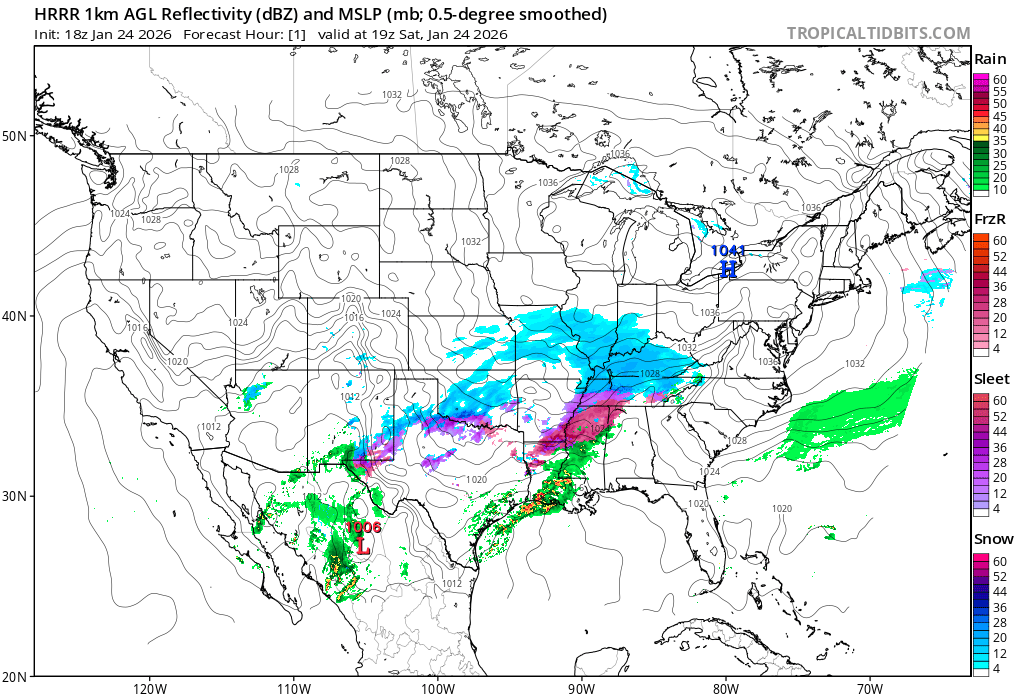
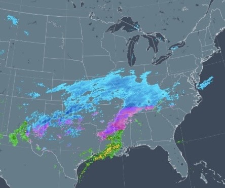
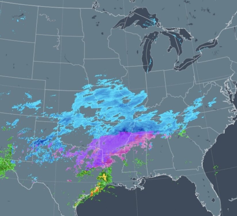
Nowcast comparison for 19z: Decent agreement, good initialization for HRRR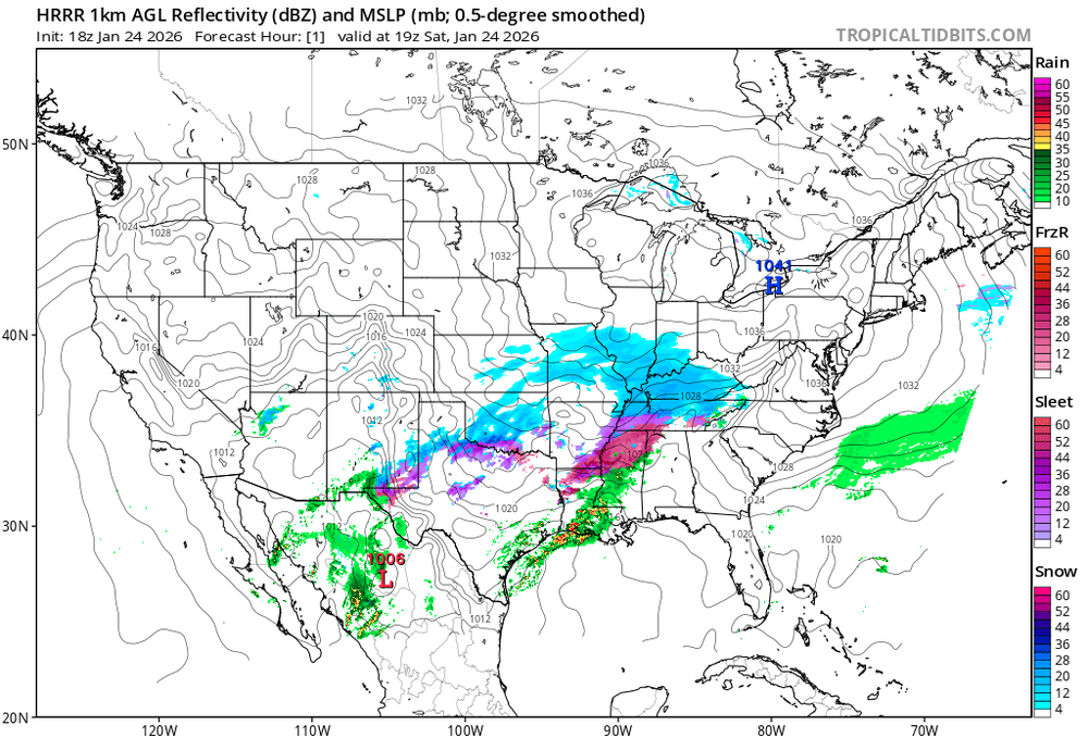
-
Jan 24-26 Weekend Snow and Sleetfest Model Thread Part Tres
Terpeast replied to H2O's topic in Mid Atlantic
Looks colder than 12z nam for the same times -
Jan 24-26 Weekend Snow and Sleetfest Model Thread Part Tres
Terpeast replied to H2O's topic in Mid Atlantic
Looks like 5-7” thump for dc metro -
16.9/-6
-
Jan 24-26 Weekend Snow and Sleetfest Model Thread Part Tres
Terpeast replied to H2O's topic in Mid Atlantic
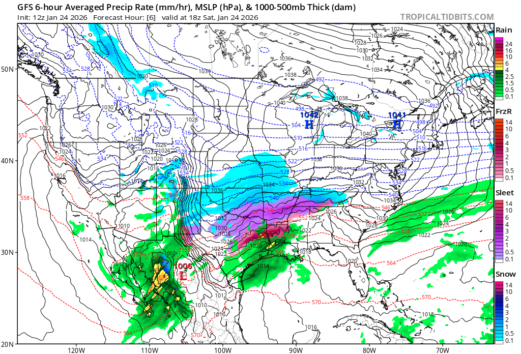
Comparing gfs forecast for 18z today with current radar Seems faster? Sleet line a bit south
-
There’s that GL low. AI is “learning” about those
-
Jan 24-26 Weekend Snow and Sleetfest Model Thread Part Tres
Terpeast replied to H2O's topic in Mid Atlantic
I think its a little bit of both. Models touched on the right idea over 10 days ago when they wanted to cut the storm west of us. Gfs had that, just too extreme with 80” snowfall in PA. That’s characteristic of ninas. But then they went way south with all that cold. We still have the cold, but models returned to their original idea. -
Jan 24-26 Weekend Snow and Sleetfest Model Thread Part Tres
Terpeast replied to H2O's topic in Mid Atlantic
It would have been a rainstorm if our temps were even in the climo range -
Jan 24-26 Weekend Snow and Sleetfest Model Thread Part Tres
Terpeast replied to H2O's topic in Mid Atlantic
Split the difference since you’re further north/NE. 5-9” perhaps -
Jan 24-26 Weekend Snow and Sleetfest Model Thread Part Tres
Terpeast replied to H2O's topic in Mid Atlantic
Sticking with the middle of the road forecast I made earlier, not panicking over the bad CAM runs. 4-8” mix/ice DC metro, 6-10” sleet fest with some zr NW -
Jan 24-26 Weekend Snow and Sleetfest Model Thread Part Tres
Terpeast replied to H2O's topic in Mid Atlantic
Yeah I thought a lot more zr, but no, just drier with precip max across PA. So far it’s an outlier -
Jan 24-26 Weekend Snow and Sleetfest Model Thread Part Tres
Terpeast replied to H2O's topic in Mid Atlantic
Nowcast precip shield more expansive than 3k nam forecast for 14-15z, with the ice line a tick further south than modeled. But just a little bit -
Jan 24-26 Weekend Snow and Sleetfest Model Thread Part Tres
Terpeast replied to H2O's topic in Mid Atlantic
Welcome to meteorology! -
Jan 24-26 Weekend Snow and Sleetfest Model Thread Part Tres
Terpeast replied to H2O's topic in Mid Atlantic
We’ve busted low recently because the temps had been too warm at the surface - is the main reason. But that’s not the case now. -
Jan 24-26 Weekend Snow and Sleetfest Model Thread Part Tres
Terpeast replied to H2O's topic in Mid Atlantic
8/-8 looks like euro/gfs are in agreement… and at odds with nam/rrfs -
Jan 24-26 Weekend Snow and Sleetfest Model Thread Part Tres
Terpeast replied to H2O's topic in Mid Atlantic
Idk, maybe something to do with gridding on its own data -
Jan 24-26 Weekend Snow and Sleetfest Model Thread Part Tres
Terpeast replied to H2O's topic in Mid Atlantic
Just fell under 20. Now 19.8 -
Jan 24-26 Weekend Snow and Sleetfest Model Thread Part Tres
Terpeast replied to H2O's topic in Mid Atlantic
Its complex, but the simple answer is that the storm is phasing much farther west than ideal for an all snow event with no temp issues. It’s still cold though. -
Jan 24-26 Weekend Snow and Sleetfest Model Thread Part Tres
Terpeast replied to H2O's topic in Mid Atlantic
Not me. I didn’t really believe the suppressed scenario and kept saying it would come north. And it did… more than I thought. -
Jan 24-26 Weekend Snow and Sleetfest Model Thread Part Tres
Terpeast replied to H2O's topic in Mid Atlantic
22 now. This cold means business -
Jan 24-26 Weekend Snow and Sleetfest Model Thread Part Tres
Terpeast replied to H2O's topic in Mid Atlantic
Thoughts about freezing rain? Probably too soon, but some CAM soundings are showing a warm nose down to 900mb at the bottom DC and SE. i’m hoping that doesn’t creep north because of the risk of power outages, and difficulty of crews getting to fix them due to the preceding snow/sleet accums. As for as mby, I’m on the dark blue line or just underneath. When I’m on the line I like to mentally split the difference, as in 6-10” max 12”. Which was what I had in mind as far as my own forecast goes. EDIT: Saw your reply to Snowen, that answers my question. -
Jan 24-26 Weekend Snow and Sleetfest Model Thread Part Tres
Terpeast replied to H2O's topic in Mid Atlantic
29 now. Was 39 an hour ago