

Terpeast
-
Posts
6,618 -
Joined
-
Last visited
Content Type
Profiles
Blogs
Forums
American Weather
Media Demo
Store
Gallery
Everything posted by Terpeast
-
Yeah, not a ton of good matches. Its too easy to go down the rabbit hole of trying to find matches on obscure indices, including old ones that haven’t been updated in years. So this time I’m picking only 3-4 of those, using one statistical methodology and sticking with it. I considered using sensible weather analogs too, but I don’t know how to do that. Too many ways to slice and dice 1-3 week periods and the number of permutations are infinite. So I won’t go there either.
-
Tracking pretty closely with 94-95, and about a month ahead of 19-20’s schedule. 94-95 is a decent analog match in some ways.
-
Great post @griteater. 66 and 73 are on my analog short list, too, as are 09-10 and a few others. Will refine with new numbers next week.
-
This. Too much hand wringing and nina-base-state-ism going on over there. We just saw the PDO rise from -3 to near neutral in a span of a few weeks. That rarely happens! One poster over there dismissed it as “noise”. Normally he is smart and insightful and I respect his content, but the “noise” comment is ridiculous. -3 to -0.3 is not noise, it’s a pattern change in process. Now I’m not saying we go super, or that we get a 09-10 redux, but this winter will give us tracking chances and the best shot at a KU since 2016.
- 921 replies
-
- 12
-

-
Wasn’t this early Sept? Before the big rise in PDO? Agree that there was a mismatch, but that’s no surprise after a triple nina and the nino was just getting started. It takes time for the extratropicals to “catch up” so to speak, and that’s still in progress. By “it takes time”, I mean several months, not days or weeks. It seems everyone is expecting things to turn on a dime within a week. Also, many here were operating under the assumption that we'd go super (and now wondering why this nino is "broken" or some hand wringing like that). I was never on board with super in the first place. I thought that would have been asking far too much after a triple nina and extreme negative PDO. However, I'll grant that the nino signal is being a bit muted by widespread warmth in all of the global oceans. It's warm everywhere. So it's like what would normally be the loudest guy in the room is now being drowned out by background noise.
-
Topped 78 before the clouds moved over
-
Mixed signals notwithstanding, I think this is the year to get a KU if we’re going to get one at all.
-
THIS is exactly why I retain some optimism for our area and not as doom-and-gloom as many posters are. If coastal areas can still get cold enough and foot+ blizzards, then we almost certainly can and will get these when the conditions are right - and this winter will be the best chance we have since 2016.
-
Yeah I really don’t agree with zip for the coast. But you know how TV mets are, they don’t really forecast for the fringes of their area.
-
That may be the case. But all the research I've been doing so far is leading me to a similar conclusion, but I'm waiting for the new runs early November and the new MEI value. I have a feeling that there'll be a new fly in the ointment, whether for better or worse.
-
Yeah, I have a feeling the next euro run will correct and hard. And likely in our favor for MA & SE
-
IAD and BWI have a chance at/near those dates.
-
Not to pile on, but...
-
Reasonable guess.
-
Yeah, a lot of mixed indicators as you and bluewave pointed out. That's why I'm leaning closer to normal temp wise here in the MA and SE. Further north will be above... and much above out towards Maine and the northern plains.
-
Ok those are interesting analogs. We know that 86 and 02 are el nino years. Not perfect matches by any means, but still interesting nonetheless. Fair enough. I've done a lot of research on the PDO in relation to the MA climo for winters, and found that we don't have to have a +PDO to have a productive winter. It can be neutral or even slightly negative. Maybe the PDO being closer to neutral allows some uncoupling for a couple of weeks at a time, a few times per winter.
-
Octorcher or Roctober 2023 Discussion Thread
Terpeast replied to Damage In Tolland's topic in New England
While I agree that access to guns should be greatly limited, especially when mental health is involved. I've seen people claiming that mental health is not the cause of the increase in mass shootings, but when I look the gun violence archive (or some similar dataset), I see a significant portion of mass shootings were committed by shooters with mental health issues. So I agree that addressing mental health is a large part of the equation. I mean... we don't want people with uncontrolled (or even controlled) mental health problems to have access to AR-15s, do we? So tragic for people of Maine. Stay safe for you folks up there. And this is having an effect on me, too. Every time I go to the grocery store, the first thing I do when I enter is look for all of the exits in the back. EDIT: My apologies @dendrite I didn't see your post to move things to banter when I typed this. Feel free to move my post there. -
We're getting there, slowly but surely. The recent PDO rise was legit, and I wouldn't dismiss it as noise. Last 15 days shows the trend we want to see. Keep in mind that I never said we're going +PDO. For the record, I don't think this is the year that we will flip. Just that we're getting closer to neutral.
.png.75bcf22b37880cd328eefaabc830b836.png)
-
This is probably a byproduct of the extreme and long duration negative pdo, and we also had to sacrifice with a -pna like pattern when the pdo rose. With october being oppositely correlated vs other months, and the MEI being much lower than nino3.4, it makes sense. But I don’t think this continues because the pdo is now near-neutral/slightly neg, and we have a new subsurface KW in the eq pac, and the MEI should rise a bit.
-
You’ve got conviction, I’ll grant you that. I see no way we’ll get to 2.1 ONI
-
1996 was my favorite. It seemed whenever someone farted, it would snow. And it would be a cold, dry, windblown snow. That winter - it was just too easy.
-
Meaning they bust too warm and it ends up colder, or they underestimate the warmth?
-
Sure. Its possible to be in the teens at the ground while its 32 aloft
-
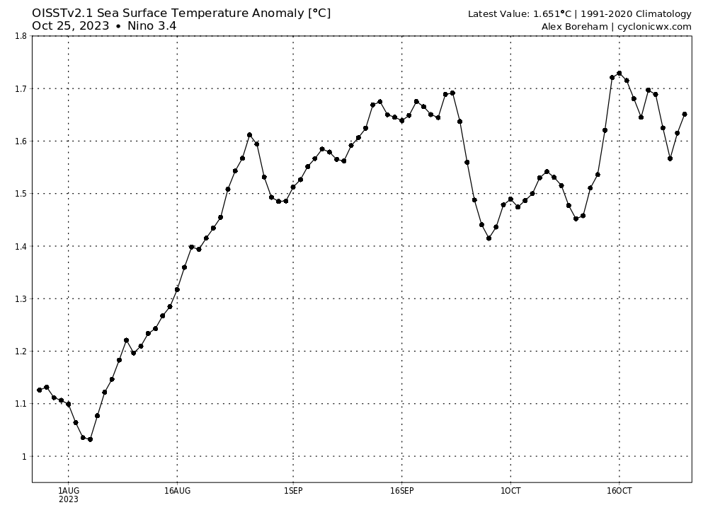
3.4 bouncing around the 1.5-1.7 range. Looks like the ONI for ASO will be around 1.4, and this nino may end up with a SON peak. It could strengthen a little, but I think we are close to peaking.
-
Are you using IOD or DMI?

