Terpeast
-
Posts
6,687 -
Joined
-
Last visited
Content Type
Profiles
Blogs
Forums
American Weather
Media Demo
Store
Gallery
Everything posted by Terpeast
-
Jan Medium/Long Range Disco: Winter is coming
Terpeast replied to stormtracker's topic in Mid Atlantic
Maybe it’s different during a nino, but last year the ensembles had tracks biased too far SE at 5-8 day leads. They eventually corrected to the op tracks. We saw the ens move NW with the mean track already. The op is too far NW for a pure snow event along I-95, but NW of the fall line still in the game. Let’s root for the 1/4 system to go ape off the coast for a stronger 50/50 -
Jan Medium/Long Range Disco: Winter is coming
Terpeast replied to stormtracker's topic in Mid Atlantic
LWX AFD on the 1/4 system - not buying into a phased scenario. Maybe this just helps set us up for the next system The aforementioned shortwave over the Great Lakes will continue to dig southeastward on Thursday. Model guidance varies quite a bit with respect to the amplitude of this feature, and how it interacts with a southern stream disturbance located over the southeastern US. Solutions vary from the northern stream staying lower amplitude/to our north and not having any interaction at all with the southern stream disturbance, to becoming higher amplitude in nature, and coming close to phasing with the southern stream system. Probabilities from ensemble guidance favor a non-phasing scenario, with a weaker northern stream disturbance progressing nearby or overhead. This would yield some low end chances for a few rain or snow showers on Thursday, with most of the area remaining dry. If the systems were to phase, there could be a stronger coastal storm, but most solutions that have that scenario playing out, have it occurring further offshore. In either scenario, the northern stream system will drive a cold front through the area, potentially leading to some upslope snow Thursday night, and colder temperatures on Friday. -
Jan Medium/Long Range Disco: Winter is coming
Terpeast replied to stormtracker's topic in Mid Atlantic
Yep, lets see if they converge on that. Probably wiggle waffle for a few days and then hone in at d4-5 -
Jan Medium/Long Range Disco: Winter is coming
Terpeast replied to stormtracker's topic in Mid Atlantic
Yeah, well I hope the gfs is right about having a cold high to the north -
Jan Medium/Long Range Disco: Winter is coming
Terpeast replied to stormtracker's topic in Mid Atlantic
How are the thermals? I don't see much of a HP up north on that panel, so that strong of a signal makes me nervous about it being to warm for us (outside of the mountains) -
Jan Medium/Long Range Disco: Winter is coming
Terpeast replied to stormtracker's topic in Mid Atlantic
Same page. I've been harping on having a vortex at the tip of the Aleutians instead of a ridge or a GOA low for months now. This is based on my MEI research, where the MEI stays below 1.2 we have a weaker Aleutian low further west compared to a strong GOA low with MEI above 1.2. This past December acted as if the MEI was above 1.2 with a GOA low with pac puke, and the horrible model runs yesterday "overcorrected" that with a nina-like aleutian ridge. Now it seems to be swinging back into the middle like a pendulum. We shall see if that "middle" is the true middle that we want, and if that does verify. -
Jan Medium/Long Range Disco: Winter is coming
Terpeast replied to stormtracker's topic in Mid Atlantic
Gefs says 1/4-5 is the stronger system, but suppressed. Trended colder on 1/7 though. Remember when both systems were depicted to be too warm to snow not too long ago though -
Wife and daughter just asked me when it’s gonna snow. I thought about the recent model runs, but I didn’t have the heart to tell them that I’m tracking something. I just said “when I see it snowing, I’ll tell you”
-
Jan Medium/Long Range Disco: Winter is coming
Terpeast replied to stormtracker's topic in Mid Atlantic
Yeah. And even if 1/4 doesn’t quite phase, it can still set us up for 1/7 as depicted by the gfs. Still way out though, I’ll start getting excited when we get it within 5 days -
Jan Medium/Long Range Disco: Winter is coming
Terpeast replied to stormtracker's topic in Mid Atlantic
Nice to see 2 runs in a row for 1/7. But I wonder how close 1/4 is to something. Gfs doesn’t quite phase the two steams yet. -
Jan Medium/Long Range Disco: Winter is coming
Terpeast replied to stormtracker's topic in Mid Atlantic
Wow... huge HUGE improvement in the Aleutian low strength and positioning. With a roll forward, we should see that produce western ridging. -
Jan Medium/Long Range Disco: Winter is coming
Terpeast replied to stormtracker's topic in Mid Atlantic
And with a SSWE / weak SPV, and we have the potential to get sustained blocking not unlike this one -
Jan Medium/Long Range Disco: Winter is coming
Terpeast replied to stormtracker's topic in Mid Atlantic
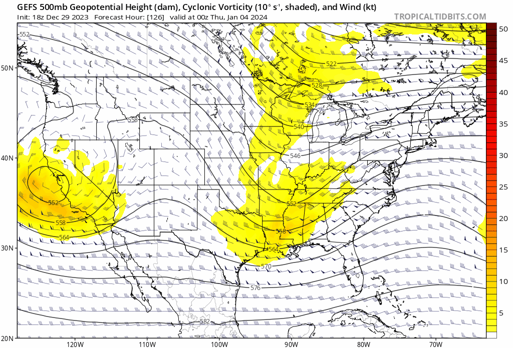
NS vort dug deeper for 1/4, but suppressed because the wave behind it is more weaker and thus more progressive, so less spacing. That adds to some uncertainty for the first event, which needs to be resolved to work out the details of the 1/7 event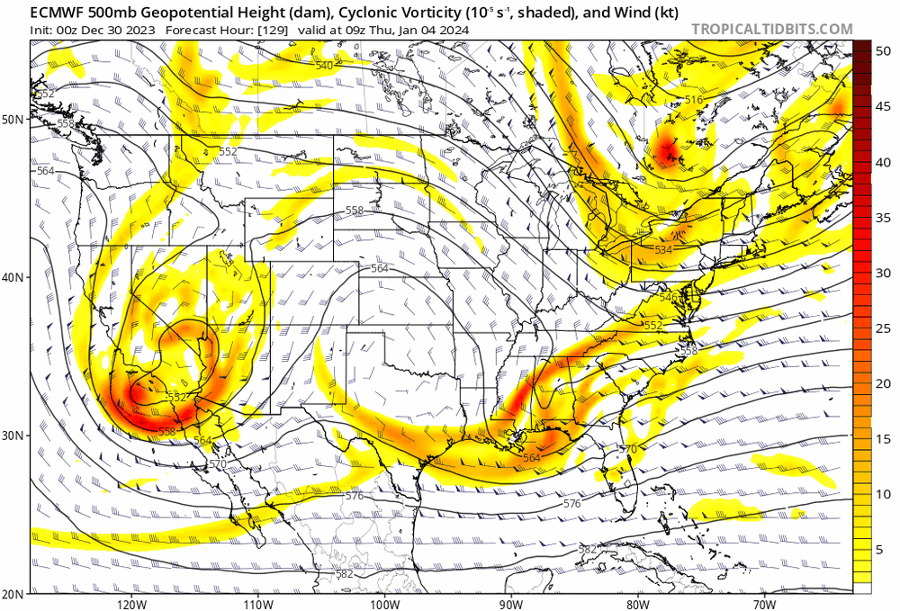
-
Jan Medium/Long Range Disco: Winter is coming
Terpeast replied to stormtracker's topic in Mid Atlantic
I’m interested in how the euro has trended in the last few runs. I’m only out to 99h on TT so I should see it soon -
Jan Medium/Long Range Disco: Winter is coming
Terpeast replied to stormtracker's topic in Mid Atlantic
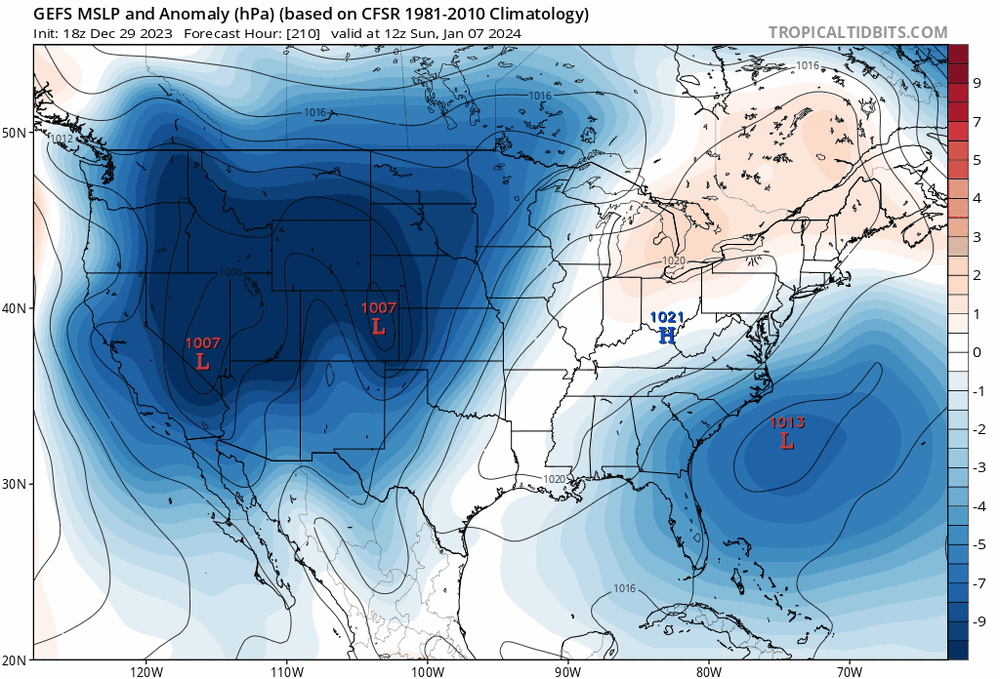
Some trends from the GEFS I'm seeing: Jan 4 - stronger high to the NW, but a bit more suppressed. This makes an amped all-rain solution less likely, but it can still miss us to the south.... ... Unless we see the NS and SS phase a bit more. Not sure I'm seeing a trend with the ensembles due to smoothing, but maybe it's very slight? Seeing that NS wave dig in a bit more? And for the Jan 7, noteworthy trend towards a stronger HP to the north with the SLP coming up a bit north.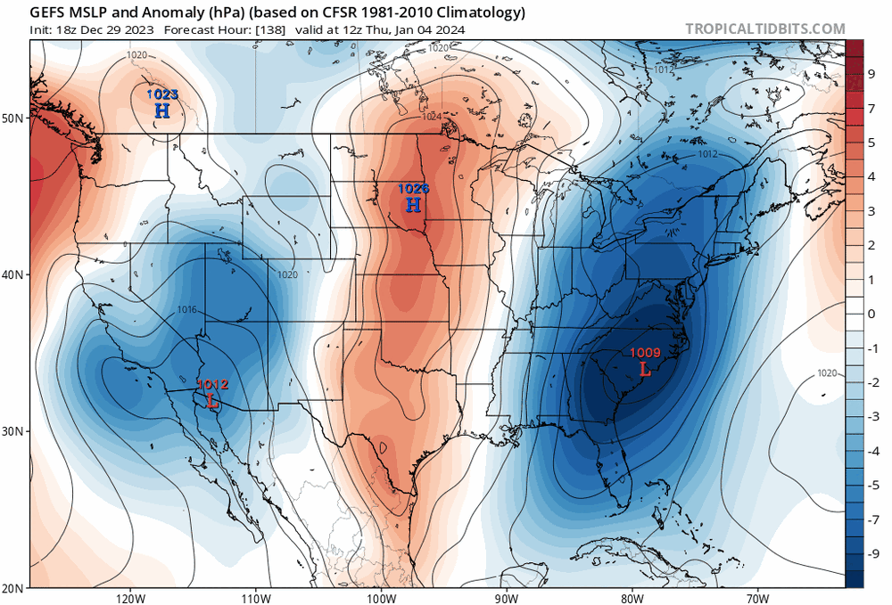

-
Jan Medium/Long Range Disco: Winter is coming
Terpeast replied to stormtracker's topic in Mid Atlantic
And it's worth noting that the 1/7 system has been way too warm at the surface for several runs the last few days. It's almost like we need the first system to go ape off the coast to bring colder air in. And that's what I noticed on the 12z gfs. Still needs ensemble support as well as the other op models. -
Jan Medium/Long Range Disco: Winter is coming
Terpeast replied to stormtracker's topic in Mid Atlantic
I wonder if the trend on 1/4 is setting us up for the 1/7 system. I’ll be watching this closely -
Jan Medium/Long Range Disco: Winter is coming
Terpeast replied to stormtracker's topic in Mid Atlantic
12z op gfs a step closer to a phase for jan 5. NS got way stronger and further S and W. End result is still suppressed, but continue this trend it may show a totally different solution
-
I have posted mine. It’s in the MA forum. It may yet go up in flames, and if that happens, I’ll learn something from it.
-
Oh, to some it does matter. The willingness to put oneself on the line at the risk of getting it wrong earns a lot more respect from me, than always being right about short term lead times. And I don’t think I’m alone in saying this.
-
Yes, bluewave’s accuracy in 1-2 week lead times has been deadly. But did he put himself on the line by issuing his own winter outlook? I haven’t seen one.
-
If you posted your own winter outlook, you’d be getting enormous credit if this played out like you’re saying. Maybe you did post your winter outlook and I must have missed it?
-
Jan Medium/Long Range Disco: Winter is coming
Terpeast replied to stormtracker's topic in Mid Atlantic
Besides we want the aleutian low at the tip of the aleutians instead of GOA, because that’s where it takes residence during more moderate/modoki ninos. Ridging pokes northward into Alaska that brings more cold air into an undercutting STJ. That’s the path to winning (in late Jan & feb) and we’re not that far off. Of course it could go sideways in the process, but now’s not the time to cancel winter. Lowered expectations? Probably. -
Jan Medium/Long Range Disco: Winter is coming
Terpeast replied to stormtracker's topic in Mid Atlantic
@psuhoffman 06z trended better in the long run. Aleutian ridge weaker, aleutian low looks like it wants to reload behind it. It’s just one run, so we’ll see.
-
Jan Medium/Long Range Disco: Winter is coming
Terpeast replied to stormtracker's topic in Mid Atlantic
Trying to pin me on what I did to you eh? This isn’t a weekly, and it’s less than 2 weeks out. Nice try @Ji