

Terpeast
-
Posts
6,596 -
Joined
-
Last visited
Content Type
Profiles
Blogs
Forums
American Weather
Media Demo
Store
Gallery
Everything posted by Terpeast
-
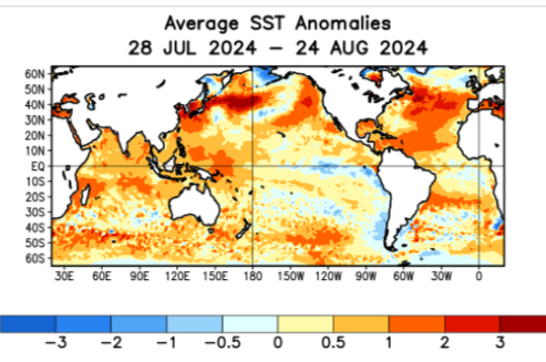
While I think we’ll see more of the same this winter, a potential wild card is that ssts off the west coast have been warming the last 4 weeks. Still have that marine hear wave off Japan and SW of the aleutians, so that’s supportive of a north pacific high on a seasonal scale. But I wonder if we’ll see a bit more -EPO blocking. Like last January, that’s our path to a serviceable albeit below climo winter. But if those waters cool back down in the fall while the Japan marine heat wave persists, I don’t see a way out of another warm and snowless winter unless a short-term fluke happens.
-
2.15" yesterday, 5.84" MTD
-
2.07” and still raining
-
Cell over me just wouldn’t quit. 1.55” and counting
-
95, HI 105
-
Most likely short term, but I think we will see a few deviations away from the nina base state going forward. Those cannot be predicted on a seasonal time scale, though
-
While the upcoming winter looks ugly on a seasonal time scale, I think it's interesting that we have had one significant BN period in the east this month and another one coming in early September. If this is a sign of things to come, 2 maybe 3 periods of significant cold should be in play in an otherwise warm winter. Kind of like last year.
-
The qbo and solar connection to our weather has always looked very weak to me. Until I dive into the data and run my own analyses, I’m open to the possibility of it being not as clear cut as you make it out to be.
-
This is really interesting… it seems for a solar max, we would prefer a westerly QBO based on that map. What was the source of this map, and what data did they use? I want to verify this myself. If you can’t get the source, no worries - I can try to use publicly available data from NOAA.
-
WeatherBell CFS maps are wrong. Apparently it has algorithm issues. @GaWx has been harping on this for months.
-
2009-10 was a neutral PDO on average after a long duration -PDO, fwiw
-
51 for the low again
-
Impressive, considering that it’s been 26 years since the last time this happened
-
51 so far
-
Forecast low for mby (between IAD and JYO) is 49. It will be interesting if that actually happens. Last time we got sub-50 in August was Aug 20, 1998 when IAD dropped to 47
-
Same. Low of 52.9
-
59.7 now imby
-
74 for the high, now 68. Loving it! Actually a bit chilly
-
Whiff
-
One might argue that the PDO went negative after the 1998 super nino, and stayed mostly negative except for a few years here and there. Or it could also be argued that it went negative after the 2016 super nino with a special flavor being the Japan marine heat wave. Depends on how you want to slice it…
-
All ensembles want to bring a wave of higher PWAT anomalies across the keys and northern Caribbean around Aug 23-24. Question is whether it organizes into a tropical low.
-
Almost got split, but got an efficient downpour that lasted 20 minutes. 0.41” the next town 3 miles north of me got absolutely hosed…
-
Right on my doorstep. Come on, push east
-
If it were November and the atmosphere/sst patterns look similar to today, I’d give it a 60% chance of a shutout and a 40% chance of eeking out an advisory/low-end warning event (of which we had 2 last January) during a brief -epo period. Beating climo? Fuggedaboutit. Too soon though. We’ll see how the tropical season pans out and how the MJO behaves in October. Either way, the upslope regions (Deep creek, snowshoe, etc) should have better winters than last year and even the year before.
-
Agreed. We were robbed there by something like the butterfly effect. I remember a few model runs showing foot-plus snows in the MA before we got rug pulled.

