psuhoffman
-
Posts
27,421 -
Joined
-
Last visited
Content Type
Profiles
Blogs
Forums
American Weather
Media Demo
Store
Gallery
Everything posted by psuhoffman
-
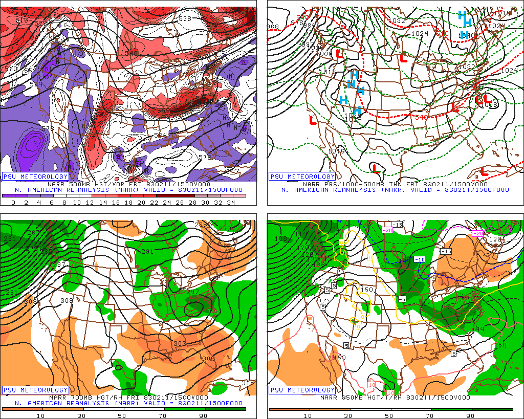
yea we were discussing that fact (the analogs) earlier. Also that 87 storm was brought up by me as an example of a snowfall distribution similar to what guidance indicates now...but it had a significantly further south H5 track and a more suppressive flow over the top. I've yet to find a big Richmond-Delmarva snowstorm with an H5 low tracking through Ohio and southern PA. Maybe we are about to witness a first!
-
Ok just something that stuck with me...the 84 hours NAM was the first indication we had that the March 2017 storm I've said has some h5 similarities was going way NW of what guidance had indicated. We tossed it of course...NAM and all...no way was our snowstorm turning into a sleet bomb...lol We have much deeper cold air this time...we want that same shift in the track this time.
-
It's the NAM so... it's the NAM but it was about to open a can on us
-
-
The H5 track was closer to that storm but still further SE than this, otherwise not a lot of similarities. Also while that hit Richmond good it also got significant 12" plus snows way up into central PA and so didn't fit the criteria of what I was looking for. In terms of the "suppression" its more similar to this, which is kind of my point. This has nothing to do with warming IMO, sometimes weird bleep just happens I got into it with him a couple years ago, now I just ignore him

-
Would love your thoughts on this... why the disconnect between the H5 track here and the models depiction of the heavy snow?
-
Thank you, that was a great explanation. Honest question: Why can't I find any examples with this H5 look and a big snowstorm for Richmond to Delmarva where all the guidance says it will be right now? They all feature a significantly further southeast H5 track.
-
That was one of the storms I included in my set earlier of close misses to our SE. But again...look at the H5 and the H7 along with the RH for that storm... Now compare it to the GFS for this storm. Look how much less suppressive the flow is for this storm in every way!
-
The WAA ahead of the whole wave is kind of baked in and you are far enough south it would be really hard to miss that. For places further north we need some amplification of the wave to gain latitude.
-
This... wanted to illustrate what I expect to see from this setup We see the duel wave structure here. The STJ wave down in the Gulf and the wave up in the TN valley which is along the arctic boundary ahead of the upper low. There should be more energy and amplitude with that TN valley wave. It doesn't have to be a lot...a few MBs makes all the difference here. We would see heavier precip also along this frontal boundary associated with that wave in the TN and lower OH valleys. Then... With that wave a little stronger, not a ton but enough to cause more southerly flow ahead of it and pull the coastal front that is the focus of the STJ wave a little further north...so the transfer of energy point is going to be further NW closer to the VA Capes. Then a stronger storm moves more NE v ENE from there. That is what that H5 is telling me the surface should look like. Hopefully this isn't just weenie wishcasting but I really am basing this off years of being used to what an h5 setup typically produces. But again...sometimes things don't do what they "should". But I'm still expecting to see this adjustment.
-
Because I decided not to finish my meteorology degree and go into education instead. I don't regret that choice. I loved my time in the classroom. Won a debate state championship. And I can do this on the side.
-
You would benefit from what I am talking about also. There are very few examples of DC getting crushed with a wave of this type and NYC missing out completely. The runs that were better for us were better for you also.
-
There will be, but it could be a combination of multiple subtle variables that act upon the outcome in a atypical way but are not easily identifiable. What we call chaos is not REALLY chaos, its just when an action is caused by something we don't have the ability to detect or comprehend.
-
Maybe...but that just looks like an artifact of a slightly higher pressure generating the H on the map but its really just an extension of the high back in the plains the axis of which is the same as the 0z run.
-
it is...except the storm IS blowing up, thats how its putting down so much snow just southeast of us. Like I said...I can buy a SE miss because the wave got flattened out and was just too weak. There are examples of that. There are several in that analog set a page back. But what you don't see in an analog set to this setup is some 10-20" snowstorm to our southeast because that means the wave did amplify, but didn't come north which makes no sense in that flow. Actually back to a point I made 2 days ago...what I see on that H5 map is that the whole focus of this storm should be the wave along the arctic boundary...the one that puts down 12" in Missouri. That is where that H5 says the wave should be and not having that die out in favor of a wave so disconnected with the upper low. A stronger wave in the TN valley would change the whole dynamic on the coast...further north transfer and closer track of the coastal. That H5 track argues a stronger primary into the KY area. And as @Terpeast said actually it argues we have to worry about too much primary and a track north of us just looking at that...I think in this case the 1055 high and cold helps mitigate that threat some. But south? SOUTH? Hope these retorts don't come off hostile, I'm enjoying the dialogue. And if this does fail I better at least learn something from it. But I think the models are missing something here.
-
the million dollar question My opinion, most likely answer is the models are wrong and this ends up further NW BUT...every once in a while things just don't behave normally and something really odd happens. This wouldn't be the first time. But 90% of the time when I identify a situation where the models don't align with what history suggests should happen, they adjust to history. The other 10% you just throw your hands up and surrender to the chaos.
-
hmmm, not dismissing this...but for the kicker to have that kind of impact...doesn't it need to impact the H5 which drives the flow? And in that case I should see other examples that looked like this and crushed just SE of us with snow but I don't. But the upper low still tracks to our NW and is plenty to the NW of the surface low not pressing it east...it's just weird to me. The weird part is to have a wave amplified enough to drop those kinds of snow totals down there...but not come north despite the flow being plenty relaxed enough and the confluence to be way up near Canada. That's why you don't see examples of this...for a wave to get "kicked" in that kind of flow it would have to be pretty weak, and a weak wave isn't dropping 1-2 feet of snow anywhere. A wave that is amplifying enough to put down that kind of snow wouldn't just turn east ahead of a cut off upper low back over Ohio and a SW to NE flow all the way to Maine with the 50/50 already to south of Greenland! Make it make sense.
-
Thanks for affirming I'm not crazy (at least not for THAT reason) or at least humoring me lol
-
I know I am beating a dead horse some here, I'm sorry, but do me a favor...humor me here... @Terpeast @Bob Chill @CAPE @WxUSAF @brooklynwx99 Just step back and look at this... (18z EPS) and tell me...is "oh no that might get suppressed" really what pops into your head? What am I missing?
-
I used to correspond with him quite a bit through email when I was a meteorology student at PSU. To be fair he was really nice, responsive, willing to help when I knew next to nothing, and was very informative. Which is maybe why I took it so hard when he went full tilt cray cray (or sellout if its all just an act) and become what he is now.
-
at least its a +PNA lol
-
@Ji I'm going to do something that makes me feel icky and dirty... quote (or in this case paraphrase for copyright reasons) JB. He just posted that in this pattern we should be more worried a storm comes straight up the coast not OTS. Also pointed out the confluence zone is up in Canada, and shout out to you, pointed out what you did about the 18z euro actually trending better at H5 but somehow east at the surface. The silly part...said the GFS and Euro are suffering from feedback...I swear he just says that anytime the models don't agree. I think they are in error but that's like a easy button cheat code thing to say. But I actually agree with the rest of it. UGH whats happening to me.
-
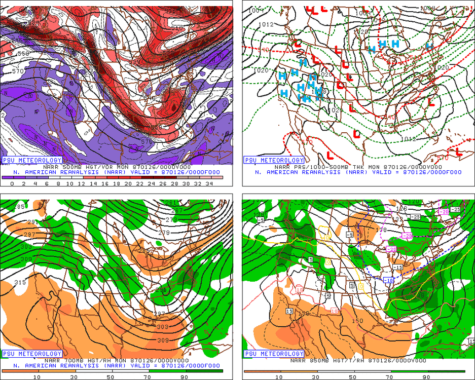
I was glad to see it on that list because it was one of the storms I identified with a somewhat similar progression when I gave examples earlier.
-
I was looking for storms where the jack zone was Richmond to Delmarva area (similar to what the miss solutions are showing right now) and all of the storms I used did deliver some snow to the whole area...Most still got 6" or so back to 95 and a lesser type storm the further NW with like 2-5" where I am. I was trying to see if this pattern fits the composite for a storm like the ensembles are hinting at...a 12" type storm for those places and a lesser storm 95 west. That just wasn't what I found. I looked at about a dozen storms and didn't see any like this. Doesn't mean there aren't any, I didn't look at every storm to ever hit that area of course. But this would not be a common H5 for a storm with a snow swath that far southeast. That typically featured a H5 path across southern VA or NC. Then when I went looking for analogs with a cutoff H5 over the upper midwest tracking through OH and MD or PA, most of the storms were actually NW of 95 jacks. That's just what I found. So "confused" describes my attitude towards the guidance.
-
Almost every scenario like that is a January 2000 type storm which isn't very applicable to this setup. It's really difficult for Richmond and DC to both jack from a SW to NE wave like this. Would have to be a crazy large snowfall distribution. That 1980 storm came really close...JUST south of DC got a lot, I posted that above. Again the H5 was tracking much further south than this setup.