psuhoffman
-
Posts
27,421 -
Joined
-
Last visited
Content Type
Profiles
Blogs
Forums
American Weather
Media Demo
Store
Gallery
Everything posted by psuhoffman
-
it would be bittersweet to call a big mid atlantic snowstorm a month out then have it crush Richmond and fringe me
-
That analog list kind of backs up my point. There are a few SE misses...but because they were really weak sauce waves not some 16" snowstorm. The March 2016 storm for example...yea it missed because the wave was a pathetic pos that didn't give anyone more than 2-4". Some of the Spring storms are hard to apply because they happened after the thermals had deteriorated such that there isn't much we can take from what would have happened in a colder regime. The rest were either DMV area Jacks or storms that Jacked just north of us.
-
I'm kinda glad you said it because I just unleashed a tirade and I didn't want it to come off as self serving or that I've lost my mind but I saw the same thing.
-
Yes but that's why I said most, not all, but most of the analogs I saw to this storm the bigger issue was a NW track not SE. The 50/50 low is really far east off the playing field here not a suppressive factor like in the examples I looked at of big snowstorms for Richmond to the Delmarva. I honestly went looking to see if this fit a close miss to our SE so I could "prepare" myself if that was how this is going to go down...and that isn't what I found. I found no examples of a storm that Jacked that area with this look.
-
Thought we had a +NAO, LOL nevermind I don't want that debate again. But... look where the height anomalies in the east are centered on the Richmond storms...down near Atlanta. They are coming across at our latitude this time. This fits the DC composite way more than the SE snowstorms one. If anything...its closer to the NYC composite of all the ones honestly!
-
Add this to my rant above... apparently the computers agree with me that this pattern doesn't align with a SE miss... again, open to evidence why I'm missing something here. Really I am
-
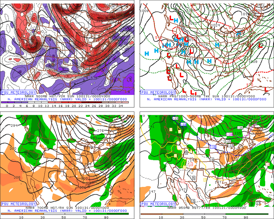
Also...look at the RH on this compared to those systems that Jacked SE VA and the Delmarva. Something just doesn't add up here. 18z GFS
-
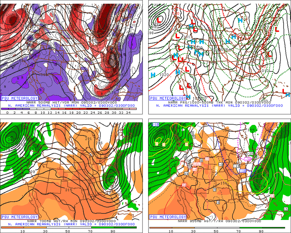
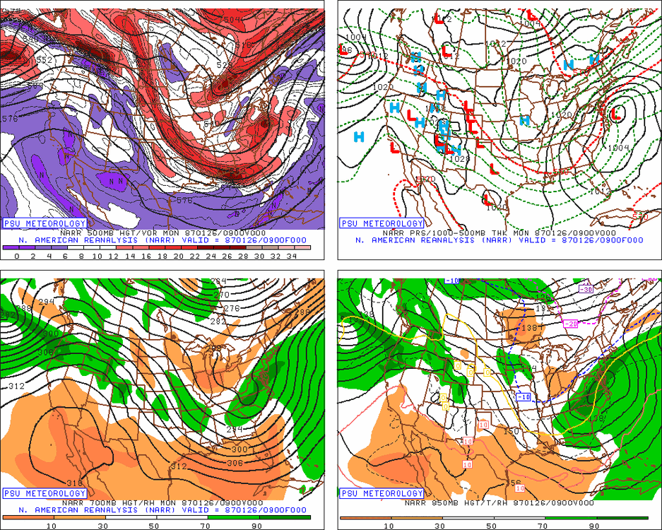
A lot of storms lately have had a relatively small significant snowfall region with unusual sharp cutoffs, which makes going from 12 to nothing more likely when the snow zone shifts 50 miles. This storm will likely have a much larger snowfall zone BUT if we are too close to the NW fringe of it, if this were to take the less amplified solutions...you know the risk. I got 4" from that, then after that and a storm in early March missed Ji said it ruined the winter lol The high is to the NW not N or NE of the system which is less suppressive. If you're referring to my comments about the analogs typically being a NW storm...I pointed out those setups didn't have the cold and high pressure to the extreme we have so it changes things. But those setups all ended up NW of progged at 100 hours. The true arctic boundary is through DC leading into the event. Yes there is cold well to our south but its not deep cold...the cold boundary down in the TN valley is shallower cold. We've got major snows well up into our area that started with a boundary there. But the key is for the wave associated with the arctic front to be the one that activates and amplifies NOT the one along the coastal front. That does not mean a cutter...the storm type I am thinking here with a somewhat similar h5 progression (DOES NOT MEAN THIS STORM GETS TO THE LEVEL OF THESE) is 1996, Feb 2006, March 2017. March 2017 is the best example of a TPV split where the storm rides up in between with a very similar H5 track of the upper low. What screwed us in that storm was the arctic boundary wave to our west amplified too much and held on way too long. I am NOT saying that should happen...but that the wave on that boundary should be the one with more focus not down over the SE so far disconnected from all the energy. Feb 2006 we had boudary issues but the 850 line was way down further south than it is here. That storm also had a wave on the arctic boundary that helped draw it up or it would have been way OTS had it focused on the coastal front. Same with 1996. If you amplify the wave a bit more along the arctic front that shallow cold south of the arctic boundary can be overcome really easy. Watch how fast that boundary can rocket NW if you amplify a wave along the boundary just a little. God knows we've seen that kill us 10000 times, why can't it help us once? When I look at the H5 track I don't see a suppressed look...usually the heaviest snow ends up close to the base of the H5 track northward and that is coming across out our latitude. It's rare to see a big snowstorm hit Richmond and Ocean City from a cut off H5 low that tracks through Ohio and PA. Find me a good example of that. If the H5 looked like this...March 1980... I would be really worried. Some other storms that Jacked SE of DC, and all of these at least got 6" into the DC Baltimore area but the Jack was SE of 95...but look at the H5 and how suppressive it is or how far south in some cases a cut off Now look at the H5 even on the GFS for our system and this is the most hostile h5 look of all the runs today...but one of these h5 does not look like all the others! Ive been looking at SE misses, you know how I obsess over every thing that can go wrong, and I don't see any that look like this at H5. That doesn't mean I think a NW miss is likely...I think the colder regime here offsets a H5 look that without a crazy 1050 high WOULD be an issue for a possible NW track. I could also see a SE miss if we had a really weak system. That isnt suppression its just a weak system not amplifying enough to gain latitude. I would be more worried about runs that don't show much snow anywhere and a 3-6" snow missing to our SE. That is very believable. But a storm amplified enough to cause a 12" snow somewhere with the H5 low that far to the NW and a flow that is not at all suppressive just sliding ENE and OTS, well its not the profile of our SE misses with 12" snows just to our SE. That said...I guess there is a first time for everything... or maybe the models end up right but for the wrong reason and the wave trends to a disconnected weak POS and there is no 10" plus snows anywhere! That would be a more typical way to miss in this h5 setup. But I don't see a scenario where MO gets 16" of snow and a wave is approaching us from the TN/OH valley with that h5 look and suddenly it gets suppressed to our south. That doesn't add up to me. I am not trying to be confrontational...I am always open to learning and I am wrong plenty so I am willing for anyone to show me where I am wrong here...I just don't see any comps to this. What I do see when I tried to find similar setups with a splitting TPV under a west based block where the western lobe splits and cuts off over the upper midwest are mostly storms that ended up if anything more amplified than we want, not less.
-
Most of the best h5 analogs I found the storm being too far northwest was a bigger issue than southeast. March 14 2017 was the best match imo at h5. But most didn’t have a 1055 high and this level of arctic air involved. But I don’t buy a weak OTS solution with this h5 setup. Feb 2010 ya. One of the 1987 storms was close to a foot in DC and nada or very little there. But the point it’s really rare is legit. Thing is there are typical interactions and a storm that’s amplified enough to get those kinds of totals up to DC rarely gets stoned immediately after. A cut off or STJ only system can slide under the NS without a full phase and blast NC and southern VA but without some NS help its unlikely to get those totals to DC. And if it does it’s not likely to be sliding due east and miss NYC.
-
Icon I’ve noticed tends to be stingy on qpf out there often. Makes sense. It’s stingier in general usually (except some odd times when it goes nuts kinda like the 3k NAM in that way) and that area is a precip shadow zone but given what their ratios are likely to be and how the valley tends to do in coastals so long as they get into the easterly low level fetch as the low passes SE of them, I’d expect them to do better. Strictly assuming this run was actually close to reality.
-
Icon gives me 12-15” of snow (assuming typical ratios here for this setup). If that happens I’ll be celebrating. And some are saying bad run lol.
-
Ya and the fact it’s usually one of the stingiest models with QPF and it just dropped .75-1.5 qpf of cold smoke across the whole area from the blue ridge to the eastern shore up into southern PA and some are making it sound like a disaster.
-
Omg @stormtracker needs to issue some red cards up in here. Some of yall make me look like an optimist or ya just trolling or drunk lol Icon: just had its best most amplified run other than the last one. That isn’t a trend it’s noise. We’re still 100 hours out. When I said guidance would start to converge on a solution pretty close to reality around 140 I didn’t mean to the F’ing mile. I meant they would do what they’ve done. We now know there’s going to be a significant storm off the mid Atlantic coast. We’re no longer looking at 200 mile shifts run to run or the storm not being there at all. Now we’re dealing with more subtle adjustments and trends that are still significant to us but a 20% change in amplitude run to run is still noise at this range! In other words the difference between this and the last run can honestly just be chance and both are equally likely
-
that looks like every big snow for us does when it’s entering the TN valley! I got 8.5” of snow and sleet from that.
-
Ironically the amplification of this window lead to a faster destruction of the high latitude regime. The TPV lobe dripping and amplifying pinwheels the block all the way into the US behind it linking with the PNA ridge and the newly developing TPV fills the void. We still have a favorable pacific with mjo in phase 8-1 so let’s see what happens. I’m not sold yet it ends so fast but some of the analogs in my set were a quicker hitting period so it’s not impossible. Take this FWIW but for days it was driving me nuts that this reminded me of something and I couldn’t place it. Then I saw a list of analogs yesterday and it hit me. March 2017. I went back through my phone and found the h5 plots I’d saved and it’s the same setup with a splitting TPV under a retrograding block and a storm coming up in between. Very similar progression. That was predicted south of reality from 100+ hours. We went from worrying about a weak storm to oh no it’s gonna change to sleet fast around 72 hours. This has a colder setup so not saying it goes that way and no two setups are exactly the same. But I don’t see how this is an overly suppressive look for is. It doesn’t match big snows that missed us south. Look at the track is the h5! They usually need it further southeast. His what? I don’t really read or watch his stuff anymore. I did check out a couple of his posts last night and saw he agrees with me on the arctic wave. Not sure if that’s good or bad!
-
Cool
-
@Terpeast also, I keep pouring over H5 analogs and they say if anything we should be worried about a miss to the NW not SE. The upper low is way to the west, the flow on top of this does not look like the suppressive shred factory we’ve seen in some recent misses to the south. I’m a little confused actually why this isn’t trending north more. Maybe it will. Still time. It’s right there. The flow ahead of the upper low isn’t bad. There is a huge weakness between the two TPVs. The Atlantic one is way east of where it’s over suppressive. And as the wave approaches the wall of confluence we typically see that kills us when a miss is coming is way up closer to the PA NY line not near us. Why is the slp swinging so far southeast before turning the corner. IMO the wave along the arctic front associated with the TPV lobe that starts to activate and produces the 12-18” snow in MO should continue to amplify east. That’s wheee the energy is. The flow isn’t squashing it. The models that miss is just suddenly amp the low way down in the gulf and kill that which is the key for us. I can count the number of big snows we’ve got that came from the south on one hand. We win with a SW to NE trajectory. We want the heavy snow coming at us from WV not Richmond. But looking at h5 I don’t see why the low is getting shoved all the way down there given the weakness in the flow and energy ahead of the upper low.
-
But what does that mean? I’m ok if I get 10” and Annapolis gets 18. But I’m gonna be a serious threat to furry creatures if I get another 3” fringe while the eastern shore gets 12+. There a huge difference between being in the “meat of the storm” but not the jack and getting fringed. The former is ok and only Ji goes nuts about. The latter has been happening a lot recently and is NOT ok.
-
It clearly increased the amplitude of the storm but didn’t help the track at all. We need the track to adjust more than the amplitude.
-
My expectations aren’t to get a 20” storm. But there is one issue, all guidance shows the jack gets plenty of snow. That’s not the issue. In my case I won’t cry if it ends up a 6-12” snow as long as I’m in it. The issue is ending up too far outside and getting 3” lol.
-
I’m a little confused how the positive changes at h5 on the uk ens made absolutely no difference on the actual surface track. The only panels I can see are mslp but dispute the much better h5 @mitchnick posted the storm track is no better at all. Not even slight west adjustment.
-
The physics based NWP don’t take history into account. They are a simulation based on initial conditions using physics to project the future. When they’re developed they do go through extensive trials and editing to make sure they match reality “as best as we are capable” lol The AI I’m much less familiar with the process of how they operate but they do take analogs into the equation but they don’t eliminate big storms I’ve seen it predict them already when there’s a chance. It showed a 20” Snow at range for us a while back for one run. It was at like 350 hours when we know not to take it seriously
-
How can it be less and not a total whiff when 6z was like 2” for us?
-
I find it odd those making the case there is a de-amplification trend on the EPS skipped the 6z run. That was actually the most amplified run there’s been! But sure if we ignore the more amplified runs it’s a trend lol. IMO we need another run or two to see if it’s a legit trend. I do find the disconnect going on between the op and ensembles across all guidance to be odd. If it was just one run I’d be even more worried we just had a fluke where all the ops spit out an unlikely outlier solution. But it’s been for several runs now across all guidance and the math on that makes it being a fluke astronomically unlikely. There is something in the physics between the ensembles and the operational causing this. All I’ll say is anecdotally I’ve noticed a disconnect like this a few times inside 120 hours. Outside that always go with the ensembles. But inside day 5 lately the operational have actually been better. At least in situations recently when the op spit out an undesirable run and we were clinging to a better ensemble, it never saved us. Oddly this was in reverse recently when the ops were less amplified and is northerners climbed to some ensemble runs with better snow lol. I would need someone more familiar with the physics behind why there might be the more less amplified divide between the ops and ens to give a more substantive analysis over which is more likely missing something. normally you take the ensemble because of the fact it’s weighting multiple members to account for a fluke outcome on the op. But at this range and given the phenomenon is across all guidance for multiple runs I don’t think it’s a fluke it’s a clear difference between the two and I don’t know what’s causing it but given the relative accuracy of the ops lately and their higher resolution I’d be inclined to side there. Unless there is a case to be made their higher resolution is tricking them into an erroneously over amped solution.
-
I do find it a little odd that across the board the op runs are more amplified compared to their ensembles. It’s been that way for a few runs now also.