

psuhoffman
-
Posts
27,421 -
Joined
-
Last visited
Content Type
Profiles
Blogs
Forums
American Weather
Media Demo
Store
Gallery
Everything posted by psuhoffman
-
No when things are bad I’m not a blow smoke up your ass rainbows and sunshine kinda person. When my team loses in the playoffs I don’t say “there’s always next year”. “Ya and the odds of us winning are no better, actually they’re worse we could suffer injuries and not even make the playoffs”. And I’m not that way with snow. You have no idea when the next opportunity with this good a setup comes along. We don’t know yet if the PDO is actually flipping. We might not get another shot like this for 5 years. Next year we could get another 2020 Or 2023 type winter! DCA only beats climo 1-2 times a decade. What if this was that good winter and we just got unlucky and missed our chance and now we have 6 more awful dreg years to suffer through before we get another! Im not who you come to for comfort if you need to see the bright side. Im a dose of reality good or bad. When it’s bad I dive into that lake of misery and swim in it. I cleanse myself in the fire through pain and suffering. And I come out the other side hardened and ready to go to battle again and take on whatever shit tomorrow has to throw at me.
-
Eagles won the Super Bowl
-
Funny I just looked and he didn’t reply to that thread lol.
-
Plot turn: as these things happen at or below our latitude less and less frequently it makes missing each opportunity even more catastrophic
-
Well now that’s starting to make more sense. I did find NC snowstorms they were decent analogs. Not VA or Delmarva ones.
-
I’m unleashing my @Ji Imma gonna need everyone to start posting as if the worst possible thing they can imagine is going to happen to them if we don’t get at least 6”, and by we I mean WE including myself and Mitchnick. I need every model run to be analyzed as if youur life depends on a warning criteria snow for the parts of this forum in a historic snow hole! I’m not in the mood for “good for Hampton roads let’s be happy for them”. Screw them they live somewhere that averages 5” if they cared about snow they wouldn’t live there.
-
I’ve made like 50 posts answering that over the last 24 hours.
-
What are we all having for our last meal tomorrow night?
-
I don’t know. Not going to pretend I understand what the error there (either before or now) is caused by. But as it continues to trend this way it’s making my arguments less relevant. They were based on an H5 look from 24 hours ago that’s becoming significantly different if that lobe doesn’t fully detach and close off its own circulation in time. Then its a suppressive instead of an amplifying force.
-
I thought the goal here was to get a NW trend not hold onto the already too far SE global solutsions lol
-
If this does get squashed...one of the biggest issues I see compared to 36 hours ago is that the TPV lobe in the upper midwest is not breaking away as clean or quickly. That is flattening the flow ahead of it and not allowing it to act as the pinwheel in the flow that we need, as a normal cut off ULL would do.
-
There are a lot of factors being tossed around about whats wrong...the biggest thing I see compared to 36 hours ago, is the TPV love is not separating as cleanly from the main TPV northeast of us as quickly or cleanly and its keeping heights down in front of it. Its flattening the flow instead of allowing that TPV lobe to act as a true pinwheel in the flow.
-
yea its early but changes are no bueno, we would need the H5 to amplify a bit more maybe to offset later
-
Or.... it could trend into an insignificant wave with no 8" plus snow anywhere...that also fits the analogs some where the TPV there squashed everything. But this in between stuff, I can't find any examples.
-
I didn't see a lot of KU examples with this H5 progression...what seemed more common was messy multiple wave or disjointed storms like you just described. The quote of mine above was in a back and forth with @Ji and not to be taken literally lol. But I was and am arguing for the possibility this should be further north. March 2017 was somewhat similar to this in terms of the H5 track but would have been way more amplified for the reasons you stated. But what I didn't find were any examples of a h5 setup like this with a closed ULL back over the upper midwest tracking through PA that resulted in a big snowstorm 8"+ for Richmond or the Delmarva like guidance has been showing. I couldn't find a single example. I found a lot of messier storms further north and a few examples of a NC snowstorm from a SS wave that had no interaction with the NS but in those cases it ended up SOUTH of where guidance is now...I saw nothing that looked like this. But I guess there can always be a first. But I do feel like if this remains as amplified as it is now, it makes more sense for the wave in the TN valley to be more amplified and the gulf wave less given the upper levels. This would translate to a further north but not as amplified system into the mid atlantic IMO. The other option would be for this to keep trending south and match the analogs I found with a true southeast snowstorm under a displaced TPV sitting over the upper midwest. Feb 1980 fits that but it was mostly NC up to VA beach with not a lot of snow north of there.
-
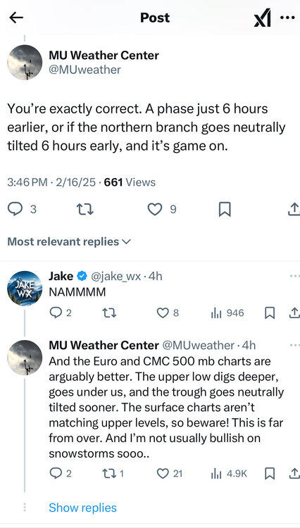
MU is seeing what I'm seeing, Courtesy of PA thread
-
I had not seen the MU stuff but now that I have I might post it in the Mid Atl, its getting grim down there. I've never, EVER, seen a closed H5 and H7 track through Ohio and MD/PA and produce a big snowstorm that misses us to the south. EVER. Can't find a single example of that with a big snow for Richmond or Delmarva. Oddly if it were to trend even further south I can find some examples of NC and VA beach snows that missed Richmond... which makes sense, either there is a strong enough wave and in that case its coming up in this setup...or its a weak wave that escapes without any NS interaction but then its gonna get sqashed even further than current guidance. So imo this storm is either going further south than models have it currently...or coming north.
-
We used to get positive busts back then also... I remember a storm in 88 where they were saying 1-3" then rain and it never changed over and we got 10". They got us to school in the snow expecting it to change to rain then took until well after dark to get us home even though they dismissed early.
-
HUGE snow...for us no. To our NW yea March 2017. There have been a few other storms, one of the ice storms in Feb 1994, One of the Feb snows in 2021 that crushed just to our north. Here is an interesting thing... the CIPS analogs focus too much on the surface when there is a major anomaly there...and that is why today's analogs are all southern snowstorms that don't look anything like this at H5, but I clicked on the upper plains the day before our event when the TPV is breaking off there...and guess what the number one analog is...Jan 6 1996! At H5 the similarity is there...the difference then was it dug all the way into the TN valley. But that was a TPV split with a lobe dropping into the US and phasing with a wave like this.
-
So you're holding firm
-
It's pretty close...but 2 things...I found a LOT of examples of a TPV being there causing nothing to happen, or very little as in a weak arse wave that didn't give anyone major snowfall. What I didn't find was a single example of a cutoff H5 low or TPV near there that gave just southeast of us a big snowstorm. Second...while its close...this marked X makes it make more sense...there is a pretty significant H5 vort rotating around that TPV through the south...we don't have that this time.
-
It's their fault, we should get them
-
I think maybe the reason I didn't see any 10" plus snows to hit the Delmarva or Richmond with this pattern...but then I pulled up Elizabeth City and VA Beach storms and the first one I picked in Feb 1980 was a decent match to this pattern... is perhaps if there is a southern wave that stays detached and doesn't phase with a TPV lobe in the upper midwest it will be suppressed but it will slide even further south then guidance was when it was showing us on the NW edge of heavy snow and crushing the Delmarva and southern NJ. Any storm that develops with a TPV there probalby has to have some interaction and come further north because if it phases at all its gonna pull it pretty far north in that flow....OR with no interaction its going to get squashed really far south because of the TPV sitting right there...there is no in between options typically. Because all guidance was showing a hit or a close miss SE when I started this I was not even considering "what if it ends up squashed all the way down to NC" lol
-
But again...look at the H5 on that storm...easy to see why that got suppressed and why it was a big SE of us snowstorm.
-
I was in NJ just southeast of Philly. Went to bed the night before expecting a foot of snow. Snowing by morning on every forecast. Woke up and could tell the sun was out from the light through my window shades and heard the wind howling out of the west and just know it was over. Crazy gradient, ACY got close to 20" and nothing for me 15 miles SE of Philly. We did get some flurries later that day on the fringe as it passed by.


