psuhoffman
-
Posts
27,421 -
Joined
-
Last visited
Content Type
Profiles
Blogs
Forums
American Weather
Media Demo
Store
Gallery
Everything posted by psuhoffman
-
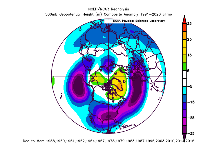
@Stormchaserchuck1 it’s not too surprising the mean anomaly you posted didn’t lead to snow most of the time. This look is decent but not really our snowy look this is the snowy season composite for BWI Note the negative in the TN valley. That’s the sweet spot. The pacific and high lat look is close but with the anomalies centered to our north it’s a cold dry look. We really want a negative anomaly centered to our SW on a winter mean to have a good chance of a snowy winter. Almost every decently big snowstorm has that. And it takes us multiple wasted good opportunities to score a hit most of the time. And we can’t get a snowy winter without hitting a couple times. So…it’s really hard to get a snowy winter without a negative on the seasonal means there. No mot impossible. It’s happened a few times. But betting on something that’s only happened a few times in 75 years isn’t a good bet. 90% of our snowy winters have a negative centered to our southwest for the season.
-
I’m not an expert but it looks typical poleward EPO ridge Nina pattern imo. There are two typical canonical Nina long wave patterns and neither is “snowy” but the more poleward pacific ridge pattern is preferable and does shift whatever cold there is into the east more. Problem is both them to be dryer and lack the gulf storms we need to have a snowy winter. But a good example of the difference is for Baltimore a poleward ridge Nina has a median snowfall of about 14” and a flat ridge Nina median is 7”. One is bad and the other is awful so we take the bad option. I excluded 1996 from these numbers because it skews everything given the small sample size and extreme results Some extra observations: I keep hearing don’t worry about the warm everywhere look but over the last 10 years we’ve had a lot of warm everywhere results so…. Also yes the LW flow looks decent but recently a decent LW pattern absent a good STJ gets us simply bad snow results vs the god awful snowless results of some winters recently. So purely based on this I’d say it’s not indicating a total non winter like 2020 and 2023 but most definitely not hinting this is the year we break out of our funk either. It implies likely a typical Nina with likely snowfall in the 7-16” range in the 95 corridor.
-
A certain someone in Baltimore keeps weenying any post that’s pessimistic about snowfall. Yet Baltimore has had 9 straight below normal and below 20” seasons and has averaged 9.7” of snow in the last 9 years. Btw the previous longest streak of below 20” winters in Baltimore was 7. But ya, it’s just cyclical and everything is fine. we are due for a big year and I’m fairly sure sometime soon we will get both a big storm and season, but we would need to get like 5 straight 30”+ seasons to even get back close to what used to be normal for the post 2016 period.
-
The PDO has a crossover effect on this. Unless we get a 1996 type fluke (very unlikely in the current PDO) a snowy winter is off the table. It’s going to be hostile. But how hostile matters. One of the biggest factors determining between a god awful or just meh winter will be the PDO. If it’s closer to -1 for the winter like last year we have a shot. If it’s hanging out around -2 to -3 we’re in trouble. But it didn’t really start to improve until around thanksgiving last year so we won’t know for a while. But it’s not just the models. Red is crushing blue in areal coverage at our latitude overall lately. And no it doesn’t mean we can’t get a snowy winter. But it does make them less likely.
-
I’ll be watching the PDO. Its spike to only mildly hostile territory last fall foreshadowed the colder winter. The dryness and lack of big coastals was a typical cold enso issue here that was common even in snowier eras. If the PDO stays in record territory though I think a non winter is possible if not likely.
-
We will know more definitely in a few years because we’ve had a few recorded snow droughts similar (if adjusted slightly snowier to account for warming). But if this carries on for more than another 1-2 years without us getting a truly snowy 30”+ winter it becomes completely unprecedented and it’s time to consider a more extreme paradigm shift has happened. I still think it’s a combo of the continued steady degradation of our snowfall combined with a cyclical minimum due to an extremely hostile PDO period. We also got unlucky that the 2 winters heading into the hostile PDO were low snowfall years which made the following PDO indices period feel worse and longer. I do think our snowfall is clearly decreasing as well regardless of the recent cycles but I doubt we’ve suddenly shifted to where Baltimore averages 10” snow. However, if we go 3 more years without a real snowy winter I will be ready to entertain that possibility
-
No but one of my 4 “snowy” winters during their 14 years was probably westherbell’s second warmest “least snowy” winter forecast. 2020-21. I was just south of the normal line for snow and temps which implied below normal and it was one of my snowiest winters of the last 20 years. But to be fair that’s super picky so to be fair I included it as one of their “near normal” predictions. They are bad enough without having to exaggerate. Their one truly warm low snow winter forecast did end up being warm and not snowy. But that’s been 80% of the winters so that’s not really a win. If they had predicted warm and low snow every year (as opposed to the opposite) they’re have a great track record.
-
To be fair WB has predicted I’d have near normal or above normal snowfall 13 of the 14 years they issued a forecast and I’ve actually had near or above normal snowfall 4 of those 14 years. ETA: I’m not disputing your specific point about his statement. But it’s hard to take anything those clowns say seriously given their track record.
-
This isn’t that complicated. It’s getting warmer. And no I don’t care if you can’t handle that fact emotionally. Either because you love snow so much or because you’ve tied your identity to rejecting facts that are inconvenient to your preferences. The thermometer DGAF about your feelings. Regression studies of snowfall are somewhat flawed imo because they apply increased temps to historical storms. Storms tracks depend on thermal boundaries so warmer temps mean the storms aren’t even in the same places anymore. But let’s simplify this. If it’s warmer in general meaning on the average storm tracks will shift north…well that means less snow for us because as you go south from here at similar elevations snowfall goes down. It’s that simple. The climate zones are shifting north with the temps. So what was once normal snow for somewhere in south or Central VA 30 years ago is now DC. Yes there will continue to be snowier and less snowy cycles and winters and there will be occasional big storms but the larger trend is really clear.
-
I agree with the general tone of your posts. but last winter was also typical of cold dry Nina’s prior to 2016. 2008-2009 was one of my top analogs and it ended up a really close match in reality. If the PDO relaxes as it did last year we might so marginally better than the typical 2017-2024 period of crap. But marginally because the background pattern drivers aren’t really good even in a pre 2017 era. We got low snow winters back then too lol. My gut says the last 8 years was a nadir and even in a lower new normal we will look back on it as a low point. But the next high snow tide isn’t likely to be as good as the last just like the last snowy period in the 2000s wasn’t as snowy as the late 1950s-1960s. The exception will be the random fluke anomaly events that will happen. And sure line up everything and another 2010 can even happen. But there will be longer stretches of snowless dreg in between those positive anomalies.
-
We can always hope for something like 1999-2000 when 90% of the winter was a hopeless garbage pattern but we got a 10 day window and scored multiple snowstorms. It takes epic good luck though. It’s always possible though.
-
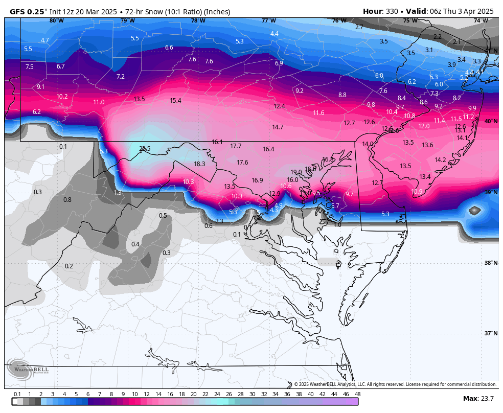
Looks perfect to me. I’ll head up to ski this for a few days then come home in time for this

-
We had 2 busts in February which were legitimate modelling errors. This though, doesn't seem to me to be a good example. If you know how to use the tool this is fine. That blizzard solution is NOT the majority solution across guidance. It's a fluke that it showed up for a couple runs on the Op GFS and one run of the Op Euro. But across the full spread of guidance, operationals and ensembles, it was a 10% minority solution at best! But 10% is not 0. It is a pretty extreme pattern. There is a non zero chance some fluke snow does happen. Its most definitely a long shot and not likely to happen...but given its not zero chance...that solution will show up on an odd run of the models here or there. And if all someone does is take that one run as if its a forecast yea thats BAD. But if you look at the guidance holistically every day, you see that is NOT the most likely outcome and was just a fluke run.
-
I do think the signal is there for an anomalous late season storm. But in the end the snow will most likely favor higher elevations and further north simply based on climo and time of year.
-
It does not mean it’s any more likely but it is odd to see two major operationals spit out similar crazy results at that range. Just something to log in the annals of the strange shit I’ve seen over the years.
-
Gfs smoked the same funky stuff
-
I’m not really in the mood but it’s likely going to be cold and miserable from March 15-April 1 so we might as well root for a fluke snow event. Even if it’s unlikely and probably just ends up some messy event that lets us down.
-
Im still keeping an eye on the period but we need a major amplification for it to work because the temps are meh and then we need it to happen pretty far south compared to where guidance is hinting. But it’s a non zero chance still something could pop up next weekend or early the week after. @WEATHER53 so….just getting caught up and did you decide to scrap the truce where we agreed to be civil and no personal attacks? We back to open season? Or was that a slip up the other day. Cause I ain’t said a thing about you since we agreed. I liked it more civil. Not sure why you felt the need to go into attack mode again when I wasn’t even here and the issue had nothing to do with you or models. So how do you want to proceed? I’m ok either way but if you decide you want open season that works both ways. Don’t complain and say it’s unfair when I respond.
-
It’s off topic. It’s not in the weather thread. And I found your jingoistic posts a few days ago to be political. But I didn’t try to stop you from expressing yourself I simply made my case why I disagreed. Then that ironically got shut down as “political”. But you haven’t had an issue making posts clearly articulating your ideological standpoint. Granted you do so in an ambiguous and subtle way but it’s picked up on. Don’t think I’ve not noticed. But then you complain when you have to be confronted by an opposing pov.
-
So I guess you decided to end the truce you asked for? Are we attacking each other personally again now? If so ok but then don’t you dare play some game where you complain I’m attacking you unprovoked or “stalking you” or some such nonsense. I’ve not said jack since you asked if we could be civil. If you want to go back to open season so be it but that works both ways. So what’s it gonna be?